effects of land use, slope gradient and soil and water
TRANSCRIPT
1
Effects of land use, slope gradient and soil and water conservation techniques, on
runoff and soil loss in a semi-arid Northern Ethiopia
Gebeyehu Tayea,b, Jean Poesenb, Bas Van Wesemaelc, Matthias Vanmaerckeb, Daniel
Tekaa,c, Jozef Deckersb, Tom Goosseb, Willem Maetensb, Jan Nyssene, Vincent Halletf,
Nigussie Haregeweynd
a Department of Land Resources Management and Environmental Protection, Mekelle University, Ethiopia b Department of Earth and Environmental Sciences, KU Leuven, Belgium c Department of Geography and Geology, UCLouvain, Belgium d Tottori University, Japan e Department of Geography, Ghent University, Belgium fDepartment of Geology, University of Namur, Belgium
Abstract
Land degradation and recurrent drought are the major threats to rain-fed agriculture in the semiarid Ethiopian highlands. To reduce the risk of crop failure induced by moisture stress and to bring food self sufficiency through irrigation, water harvesting has become a priority in the Tigray region since the last two decades. However, the success of water harvesting scheme is very limited due to siltation, seepage, and inflow reduction. Catchment level installation of Soil and Water Conservation Techniques (SWCT) are major causes for inflow reduction. The aim of this paper was to investigate the effect of typical land use types, slope gradient and different SWCT on runoff and soil loss at runoff plot scale. Six runoff measuring sites corresponding to gentle (5%), medium (12%) and steep(16%) slope gradients were established for cropland and rangeland at May Leiba catchment in central Tigray (Ethiopia). For each site on rangeland four runoff plots were installed in 2010 and treated with three SWCT, stone bunds, trenches and stone bunds with trenches, in addition to a control plot. Similarly, for each site on cropland three runoff plots were installed and treated with stone bunds, stone bunds with trenches plus a control plot. These 21 large runoff plots (length: 60 to 100 m; width: 10 m) were monitored for runoff production and soil loss during the main rainy season (July-September). The results showed that, seasonal runoff coefficient (RCs) and seasonal soil loss (SLs) were higher in rangeland compared to cropland. RCs for rangeland ranges from 0.4 to 0.5 while it ranges from 0.16 to 0.25 for cropland. SLs were 3 to 5 times larger on rangeland (30 to 50 ton ha-1) compared to cropland (6 to 19 ton ha-1). Introduction of SWCT strongly reduced runoff production and soil loss –on both land use types and slope gradients. Stone bunds with trenches were the most effective SWCT in reducing runoff and soil loss. With the same SWCT applied, RCs and SLs for both rangeland and cropland tend to decrease with increasing slope gradient mainly due to increased rock fragment cover. The effects of SWCT on runoff production and soil loss are very considerable, hence it is important to consider these effects for optimal design of water harvesting schemes in Ethiopian highlands.
Gebeyehu Taye, Poesen, J., Van Wesemael, B., Vanmaercke, M., Daniel Teka, Deckers, J., Goosse, T., Maetens, W.,
Nyssen, J., Hallet, V., Nigussie Haregeweyn, 2013. Effects of land use, slope gradient, and soil and water
conservation structures on runoff and soil loss in semi-arid northern Ethiopia. Physical Geography, 34(3), 236-259.
2
Keywords: Ethiopian highlands, Tigray, runoff, soil loss, cropland, rangeland, stone bunds, trenches
1. Introduction
The highlands of Ethiopia have suffered from severe land degradation processes (Bewket and
Sterk, 2003, Nyssen et al., 2004). Low input and traditional farming practices (Hailesilassie et
al., 2005), combined with a rapid population growth (Hurni et al., 2005) and encroachment and
cultivation of more marginal areas contributed to unprecedented rates of soil erosion by water
and nutrient depletion (Osman and Petra, 2001). As a result of severe soil erosion processes
and complete removal of top soils, large areas of the Ethiopian highlands have already lost
production potentials (Esser et al., 2002) with exposed subsoils and rock outcrops. In response
to this, the government of Ethiopia has started a large-scale soil and water conservation
campaign particularly in drought-prone areas of the highlands (Nyssen et al., 2007a) such as
the Tigray region. Low agricultural productivity in this semiarid region is not only due to land
degradation, but also caused by moisture stress that exists during 8 to 9 months of the year
(Gebreegziabher et al., 2009) which is also the result of seasonal and erratic rainfall
(Haregeweyn et al., 2008). More than 85% of the population in this area depends on
subsistence agriculture, which is rain fed, and is highly threatened by recurrent drought
(Welderufael et al., 2008). Due to a decrease of vegetation cover through deforestation,
overgrazing, as well as a low water retention capacity of the soils, runoff production from
Ethiopian highlands has increased (Osman and Petra, 2001) with considerable off-site and
trans-boundary consequences (Hurni et al., 2005; Bewket and Teferi, 2009).
An attempt has been made at different levels to reduce the effect of moisture stress on
agricultural productivity in the region through water conservation, water harvesting and irrigation
development. Hence, the regional government of Tigray established a Commission for
Sustainable Agriculture and Environmental Rehabilitation in Tigray (CoSART) in 1994 to
promote water harvesting at the scale of micro-dam catchment and irrigated agriculture
(Haregeweyn et al., 2008). The commission started with a plan to construct 500 dams and
irrigate 50,000 ha of land in Tigray in ten years time (Haregeweyn et al., 2006). However, only
54 dams were constructed from 1994 to 2003 due to design problems leading to some bad
experiences with dams not functioning according to expectations.
3
Haregeweyn et al. (2006) emphasized that the most important challenges related to water
harvesting schemes are siltation, and less water storage in the reservoirs compared to the
design capacity. Losses due to seepage, evaporation and to introduced soil and water
conservation (SWC) structures are not well documented. Haregeweyn et al. (2006) has
observed inflow differences into the reservoirs between the years before and those after
treatments of the catchment with SWC structures constructed to reduce sediment inflows. In the
first one to three years after dam construction the inflow was high in some reservoirs as
evidenced from old maximum flood marks observed on the dam body. However, with the
implementation of SWC structures within the catchments, the runoff volume delivered has
sharply decreased and maximum flood marks were not attended any more. This indicates that
the impact of physical SWC structures on the hydrological responses of the catchments has
been overlooked during the planning and the design phase of most water harvesting structures
in Tigray.
Moreover, recent studies focused on the economics and adoption of SWC in Ethiopia (e.g.
Shiferaw and Holden, 1999; and Bewket, 2007) and their effectiveness in reducing soil loss and
increasing crop yield (e.g. Gebremedhin et al., 1999; Herweg and Luid, 1999; Desta et al.,
2005; Vancampenhout et al., 2006; Nyssen et al., 2007a and Adgo et al., 2013). But no or little
attempt has been made to investigate and quantify the impact of the ongoing SWC structures
on rainfall runoff response and soil-water abstraction. Studies on the effectiveness of SWC
structures on soil loss reduction have also focused mainly on stone bunds (Desta et al., 2005
and Nyssen et al., 2007a) and therefore, the effectiveness of trenches and stone bunds with
trenches, which are also intensively used SWC techniques (SWCT) in the region are not
addressed. Hence, understanding the impact of SWC treatment on the hydrological response
and soil loss is crucial for a proper planning and design of water harvesting schemes. It is also
important to resolve conflicts of interest arising between soil and water conservation in the
catchment using different SWC measures and collecting runoff in the reservoir for irrigation.
Therefore, the overall objective of this study is to better understand the effects of typical land
use types, slope gradients and SWC structures on seasonal runoff and soil loss in Tigray. More
specific objectives are:1) to quantify the effect of typical land use type on seasonal runoff
production and soil loss; 2) to understand the effect of slope gradient and ground cover on
4
runoff production and soil loss; and 3) to quantify effects of SWCT on seasonal runoff
production and soil loss.
2. Materials and Methods
2.1. Study area
May Leiba catchment is located in the central administrative zone of Tigray, in the district of
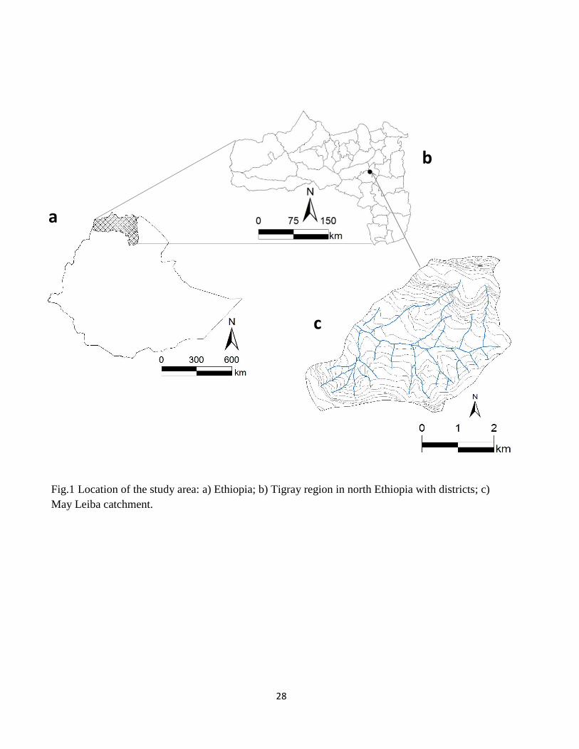
Dogua Tenbein north Ethiopia. It is geographically located at 13°41'N–39°15’E, (fig.1), at ca 40
km west of Mekelle, the capital of Tigray. The average altitude of the study area is 2450 m a.s.l.
The May Leiba dam is situated at the outlet of the study catchment at 2290 m.a.s.l. and the total
area of the catchment draining towards the dam is ca 18km2 (Van de Wauw et al., 2008). Tigray
is characterized by a cool tropical semi-arid climate with extreme rainfall variability. Annual
average rainfall varies between 500 to 800 mm (Virgo and Munro, 1978). Most rainfall (>85%)
occurs during July and August (Gebreegziabher et al., 2009; Gebreyohannes et al., 2012). Due
to a large intra and inter annual rainfall variability (20 to 40%), the region is exposed to severe
moisture deficiency during the growing season which is only 45 to 120 days (Gebreegriabher et
al., 2009). The rainfall is erratic with more than 75% of the rains falling at intensities larger than
25 mm/h inducing severe soil erosion (Virgo and Munro, 1978). Nyssen et al. (2005) showed
that even low intensity rainfalls have a bigger drop size resulting in high rain erosivity. Monthly
rainfall in this region is below monthly potential evapotranspiration except in August. The long-
term average (15 y) annual rainfall measured at Hagere Selam, 12 km South west of May Leiba
catchment, is 724 mm while average monthly temperature ranges from 12 to 19C°.
2.1.1. Geology and soils of the May Leiba catchment
The lithology of the May- Leiba catchment is described as part of the Mekelle outlier which is
composed of Mesozoic sedimentary rocks comprising Adigrat sandstone, Antalo limestone and
Amba Aradam sandstone, being buried under Tertiary flood basalts. The upper 8 m of the 50–
100m thick Amba Aradam formation is very resistant to erosion and impervious. Van de Wauw
et al. (2008) described the lithological composition of May Leiba catchment in detail indicating
that, the top of the table Mountains consists mainly of Amba Aradam sandstone of Cretaceous
age and two series of Tertiary basalt flows. Silicified lacustrine deposits can also be locally
found in between these basalt layers (Garland, 1980). Tectonic uplift in the order of 2500 m has
5
resulted in the formation of stepped and tabular land landforms (Nyssen et al., 2007a). Soil
variability is rather complex due to landsliding and intense erosion and deposition processes.
Basaltic material has been displaced from the plateau over the sandstone cliff and is spread on
limestone parent materials (Van de Wauw et al., 2008). Typical soils of the May Leiba
catchment include Luvisol– Regosol-Cambisol-Vertisol along a catena. Vertisols are only found
on footslopes and their thickness typically exceeds one meter. The area is also conducive for
the formation of smectitic clays due to alternating dry and wet cycles and continuous
enrichment of bases from basaltic parent material.
2.1.2. Land use and agricultural systems
Cropland and rangeland are the dominant land use types in May Leiba catchment. Rangelands
are mostly situated on steep slopes with very shallow and stony soils. They are collectively
owned and marginalized in terms of land management interventions such as SWC. Moreover,
these rangelands are overgrazed particularly during the cropping season when animals are only
kept on rangelands. More than 65% of the catchment area is used for annual crop production
(Nyssen et al., 2007a). The most common crop types are cereals such as Barley (Hordeum
vulgare), wheat (Triticum sp.), teff (Eragrostis tef), grass pea (Lathyrus sativus), chickpeas
(Cicer arietinum) and lentils (Lens culinaris). Soil tillage is carried out with traditional ard plough
‘maresha’ pulled by a pair of oxen and the frequency of tillage ranges from 3 to 6 per cropping
season depending on crop types and even 5 to 8 times for teff (Bewket and Sterk, 2003;
Tulema et al., 2008). Croplands are owned and managed by individual farmers. Fertilizer use
depends on the rainfall distribution, hand weeding and postharvest stubble grazing is also a
common practices. Use of organic fertilizer is very limited in the Ethiopian highlands in general
as crop residues are used to feed animals while animal manure is used to provide household
energy. There are still land use changes in the area, rangelands which are in a better condition
are continually converted to cropland whereas degraded rangeland is converted to exclosures
for vegetation restoration (Descheemeaker et al., 2006). Due to these land use changes the
current area under rangeland is decreasing while putting the remaining rangeland under
increasing grazing pressure (Girmay et al., 2009).
2.2.3. Soil and water management
6
SWCT are intensively installed at May Leiba catchment to control soil erosion and conserve
moisture. Farmers have a long tradition of conserving soil and water using stone bunds. There
are stone bunds of more than 20-30 years old in the area. Some farmers redistribute fertile
sediments which accumulated behind stone bunds over their field and others move stone bunds
and redistribute the sediments during tillage (Mitiku et al., 2006). Soil fertility management is
poor and the use of chemical fertilizers is low due to a low economic return and the risk
associated to crop failure during dry years. Organic materials such as household waste and
manure are rather being used for household energy than for fertility management. Water
harvesting and conservation are key to secure crop production. Stone mulching and structures
such as deep trenches, check dams, stone bunds, stone bunds with trenches and trenches are
used for in-situ moisture conservation. On the other hand micro-dam reservoirs and household
ponds were also installed for water harvesting and to provide water for supplementary irrigation
(Haregeweyn et al., 2006 and Berhane et al., 2013).
2.2. Study sites and methodology
May Leiba catchment was selected due to its representativeness of the catchments in the
Tigray highlands in terms of altitude, geomorphology, land use and density of SWC structures.
The catchment has been treated with different SWC structures such as stone bunds, trenches,
stone bund with trenches, check dams and exclosures. Stone bund density is the highest on
cropland compared to rangeland. May Leiba reservoir is situated at the outlet of the catchment.
It was constructed in 1998 to harvest runoff water for irrigation. However, despite a huge capital
and labour investment to install this reservoir, it has never been used for irrigation apart from
livestock watering. Loss of water from this reservoir due to seepage provides continuous base
flow supplying water to the communities in downstream. Most reservoirs (70%) in Tigray have
had siltation problem due to excessive hillslope erosion (Haregewyn et al., 2006; Tamene et al.,
2006) reducing their life expectancy by 50%.
A reconnaissance survey was conducted to identify plot measuring sites for major land use
types in January 2010. Six representative sites corresponding to gentle (5%), medium (12%)
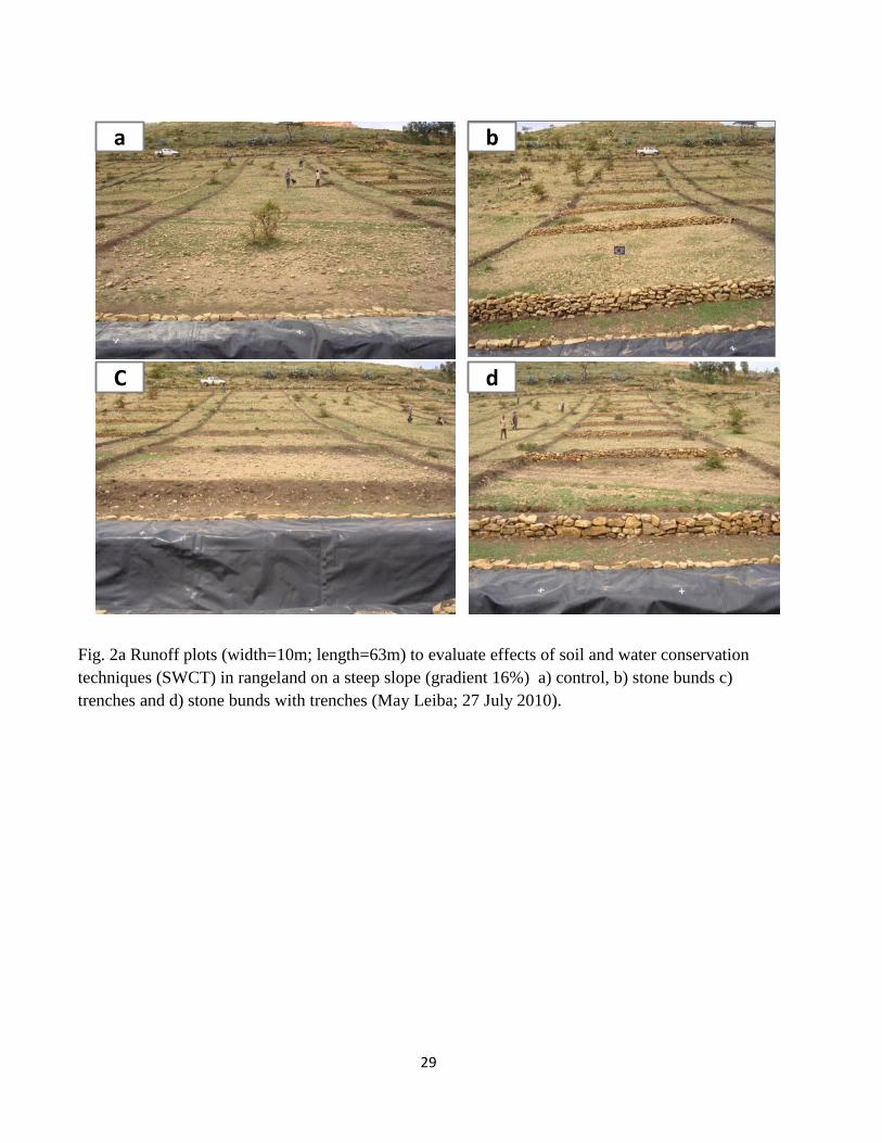
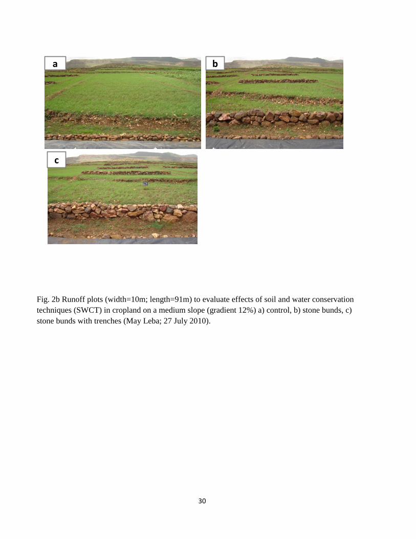
and steep (16%) slope gradients were identified for rangeland and cropland. For each site on
rangeland four runoff plots were installed (fig.3): one control plot and three plots treated with
different SWCT: i.e. stone bunds, trenches and stone bunds with trenches (See Table 1, fig.
7
2a). For each site on cropland three runoff plots were installed (fig.3): one control plot and two
plots treated with different SWCT: i.e. stone bunds and stone bunds with trenches (Table 1, fig
2b). Plot design is similar to that of Nyssen et al. (2001), Gebreegziabher et al. (2009) and
Araya et al. (2011). The spacing of SWCT which depends on slope gradient (Table 1) is based
on regional guidelines (BoNAR, 1997). Each plot was kept 3 m apart from an adjacent plot and
bounded with 45cm wide and 30cm high soil bunds. The soil bunds were compacted during
installation and maintenance and were supported with stone riprap so as to protect the bund
from degradation. During and after each storm, plot boundaries were checked for any damage
and repaired if necessary. At the lower end of each plot a collector trench was installed and
lined with a geomembrane (0.5 mm thick) to harvest all the runoff and sediment generated
within the plot. The collector trenches are 10 m long, 2 m wide at the surface, 1 m wide at the
bottom and 1.2m deep. The capacity of the collectors was determined based on a maximum
daily rainfall of 70 mm and a maximum runoff coefficient of (25%) observed in Hagere Selam
area (Nyssen et al., 2007b). Diversion ditches of sufficient capacity were also dug immediately
upslope of the plot sites to intercept and divert run-on from upslope areas.
2.2.1 Technical standards of SWC structures
There exists much discrepancy between recommended dimensions of SWC structures and
actual farmer’s practices in the Ethiopian highlands (Desta et al., 2005). Farmers compromise
for land occupied by SWCT, farm operation such as tillage, availability of construction materials
and soil types to determine the spacing of SWCT on their field. In this experiment however,
recommended technical standards were used to set the spacing of SWC structures (see Table
1).
A stone bund is an embankment of stone wall that is built along the contour perpendicular to the
slope. The wall is built of large stones (10 to 40 cm) while small rock fragments (5 to 10cm) are
used as a backfill material (Nyssen et al., 2007a). The purpose of stone bunds is to reduce
runoff velocity and to filter sediments and crop residues behind the stone bunds leading to
progressive terrace development. Stone bunds have been widely installed in Tigray since 1981
(Desta et al., 2005). These structures, being 80 cm wide and 70 cm high (front) were installed
at 15 cm foundation depth and their spacing depends on slope gradient (see Table 1). Since
8
removal of rock fragments affects soil surface conditions care has been taken during installation
of stone bunds not to remove surface rock fragments within the plots.
Trenches (Fanya Chini) are across slope barriers consisting of ditches and earthen
embankments. The ditches are typically 0.5 m wide, 0.5 m deep and 3 m long and successive
trenches along the contour are separated by 60 cm earth structures similar to tied ridges. The
embankment is made of excavated soil that is thrown downslope. The ditch traps all the runoff
and sediment coming from the upslope inter-trench area. When the ditch is filled, some of the
runoff water is still trapped by the embankment. Trenches are commonly installed on rangeland,
bushland and exclosures (Nyssen et al., 2008) for maximum infiltration and for medium to
gentle slope gradients where soil depth is not a limiting factor. Their staggered arrangement is
also important for increased interception of surface runoff. In this experiment this arrangement
of trenches was achieved by alternating three and four trenches along the slope. The spacing of
trenches along the slope also depends on slope gradient (see Table 1) for the spacing. On
cropland this structure is not compatible with farming operations and also filled in soon after
installation due to tillage erosion. Progressive sediment accumulation in the ditch will over time
decrease trench efficiency to trap sediment and water. The dimensions of the trench can vary
based on their purpose. Recently very large-sized (2 m by 10 m) and up to 1 m deep trenches
are implemented in Tigray region to increase infiltration to deep groundwater for downstream
irrigation and livestock watering. In this case they are commonly installed at the foot-slope of
the escarpment to intercept flash floods and to protect sediment deposition on cropland.
Stone bunds with trenches are a combination of stone bunds and trenches. After installation of
stone walls as in the case of stone bunds on the contour, trenches are dug upslope immediately
behind the stone wall and the excavated soil is used as a backfill material. This structure is a
modified version of stone bunds and was mainly implemented since 1999 to increase the
effectiveness of stone bunds in soil moisture conservation and have similar spacing with stone
bunds. They are introduced in response to farmers’ complain against complete removal of small
rock fragments from the soil surface during installation of stone bunds (Nyssen et al., 2001).
Therefore, instead of rock fragments, rock fragment rich soil can be excavated behind the stone
wall and used as backfill and topping material. In terms of length along the contour trenches
9
cover only 82 to 88% of the length of stone bunds. Under actual farmers practice the cover is
75% mainly due to spaces left between successive trenches (Nyssen et al., 2007a; , 2010).
2.3. Measurement procedure
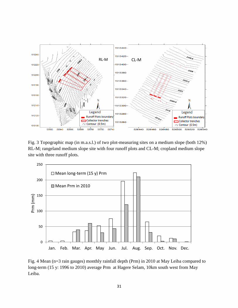
Three manual rain gauges were installed in 2010 for rainfall measurement within May Leiba
catchment. Daily rainfall depth at each runoff-measuring site is then obtained through
interpolation (isohyets) of the rainfalls measured at these three stations. Daily runoff depth is
measured in each collector trench at five fixed and marked points in the morning at 8:00 am.
The runoff is then thoroughly mixed using floor brush and depth-integrated runoff samples were
collected to determine sediment concentration after filtering and drying the residue. Each
collector was emptied manually every morning after runoff depth measurements and runoff
sampling and geomembranes were inspected for leakages after runoff removal. The fact that
most rains come in the afternoon makes data collection on a daily basis and without
overlapping rains possible. Nyssen et al. (2005) also reported that about 84% of the rains in the
area fall in afternoon and evening.
The line transect method (Jennings et al., 1999) was used to monitor the cover by vegetation
(VC %), rock fragments (Rfc %) and bare or crusted soil surface on a weekly basis. A tape
meter was stretched from bottom end to top end of the plots in two transects and 2 m away into
the plot from plot boundaries. At each 50 cm interval the type of ground cover was recorded
and cover percentage was calculated.
Slope gradient of each site was measured using a clinometer and soil types were described
using FAO guidelines for soil description (FAO, 2006) of soil profile in the collector trenches.
Based on the location of the sites, soil classification is deduced from the soil map of May Leiba
catchment (Van de Wauw et al., 2008). Gravimetric rock fragment content (Rfm, %) in the soil
profile was determined after drying, grinding and sieving composite sample. The soils found on
the gentle sloping sites of both land use types have well-expressed vertic properties. Clay and
clay loam texture is a common characteristic of soils at all sites (Table 1).
Measurement accuracy for daily runoff and soil loss were evaluated and the associated errors
at plot level were ( 0.32 mm for runoff depth and 1.3 g/l for sediment concentration. Rating
curves (water depth-volume relationships) were developed for each collector trench and used to
10
calculate runoff volume and runoff depth. The depth of rain falling directly on the collector
trenches and the outside frame of the plastic is subtracted from areal runoff depth. Seasonal
runoff coefficients (the ratio of seasonal runoff depth to seasonal rainfall depth) were calculated
for each plot. Top soil bulk density (0-10 cm soil depth) for each plot was determined using the
core method and corrected for rock fragment content following (Torri et al., 1994). Soil organic
carbon of each plot was determined using wet oxidation Walkley-Black method (Walkley and
Black, 1934) for composite soil samples collected randomly from different parts of a plot.
Particle-size distribution was determined using hydrometer methods (Gee and Bauder, 1997).
In this study we use large runoff plots (see Table 1 for plot dimensions and fig.2a, b).
Replicating such runoff plots is not practically possible in our case due to several reasons: i.e.
very rugged hillslopes with rock outcrops, soils and geology that vary over short distances, lack
of sufficient rangeland sites for all slope ranges, and the fact that a large runoff plot involves
different farmers with different choices of farm management and crop rotation. Despite this
limitation we believe that such large runoff plots yield representative measurements of seasonal
runoff and soil loss under existing land management practices. Moreover, the fact that these
plots are designed to test 3 to 7 SWC structures per plot depending on slope gradient (see
Table 1), will help to evaluate their effectiveness when installed on a specific land use type and
slope gradient.
3. Results
3.1. Rainfall
There is a large temporal and spatial rainfall variability in Tigray even at the catchment scale.
Most of the annual rain (ca >80%) falls during a short period, i.e. June to September. The long-
term average monthly rainfall (15 y: 1996 to 2010) recorded at Hagere Selam ca 2650 m.a.s.l.
(located at 12 km south-west of May Leiba catchment) is compared with mean monthly rainfall
(n=3 rain stations) recorded in 2010 at May Leiba catchment (ca 2350 m.a.s.l.; see fig.4). Long-
tem mean annual rainfall at Hagere Selam was 724 mm while mean annual rainfall recorded in
2010 at May Leiba was 551 mm. Although there is an altitudinal difference between May Leiba
and Hagere Selam, annual rainfall at May Leiba in 2010 was less than the long-term average
and therefore, the year 2010 is relatively a dry year. During almost all the months, long-term
average monthly rainfall at Hagere Selam (fig.4) is greater than monthly rainfall recorded in
11
2010 at May Leiba. The period from mid of June to mid of September is locally called kiremt or
main rainy season. During the period from October to May (8 months) rains are small, highly
variable and unreliable and therefore, the area is characterized by a unimodal rainfall pattern. In
2010 we sampled rainfall from 15 July until 09 September for this study, and our sample
covered 68% of the total annual rainfall.
3.2. Runoff production and soil loss
3.2.1. Effects of land use and slope gradient on seasonal runoff
The effects of land use and slope gradient on the seasonal runoff coefficient (RCs) are
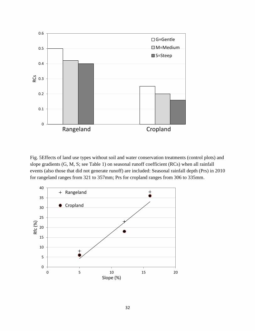
illustrated in (fig.5). RCs (0.4-0.5) were significantly higher for rangeland compared to cropland
(0.16 to 0.25). The lower RCs values for cropland relative to rangeland can be attributed to soil
tillage. At the beginning of the rainy season cropland is tilled before the major storms arrive
while rangeland plots had compacted soils which had almost no vegetation cover after a long (8
months) dry period. Though the purpose of soil tillage is to control weeds and seedbed
preparation we observed that tillage also creates furrows and ridges that can intercept and
store a considerable volume of surface runoff during the storms. Moreover, unlike the
rangelands which were intensively grazed during the rainy season, vegetation cover on
cropland increases linearly from almost no cover at the beginning of the rainy season to over
84% cover towards the end of the season. On rangeland vegetation cover changes more
frequently and non-linearly due to continuous grazing and trampling by livestock during the
season. On both land use types RCs decreases as slope gradient increases, which is attributed
to an increasing surface rock fragment cover favouring infiltration with increasing slope gradient
(fig.6).
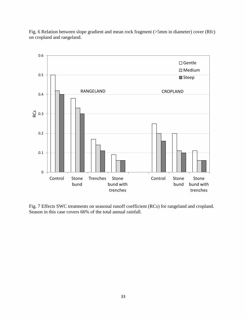
3.2.2. Effects of SWCT on seasonal runoff
SWCT strongly affect seasonal runoff coefficient (RCs) and this effect was much larger on
rangeland compared to cropland (fig.7). Stone bunds with trenches were the most effective in
reducing runoff on both land use types followed by trenches on rangeland and stone bund. With
the SWCT installed, RCs decreases with increasing slope gradient for both land use types
(fig.7). This is attributed to the effects of rock fragment cover (Rfc) favouring infiltration and
which also increases with slope gradient (fig 6). The soil texture at all sites was clay and clay
12
loam (see table 1), however rock fragment content (Rfm) within the soil profiles to 100 cm depth
also increases with slope gradient. In rangeland Rfm increases from 18% to 29% while on
cropland from 14% to 51% from gentle to steep slopes respectively. Thus a high content of rock
fragment in clayey soils might have facilitated infiltration and hence results in lower runoff
responses with increasing slope gradient. Soil saturation was also observed for the medium
and steep slope sites for both land use types during the measurement period.
3.2.3. Effects of land use and slope gradient on seasonal soil loss
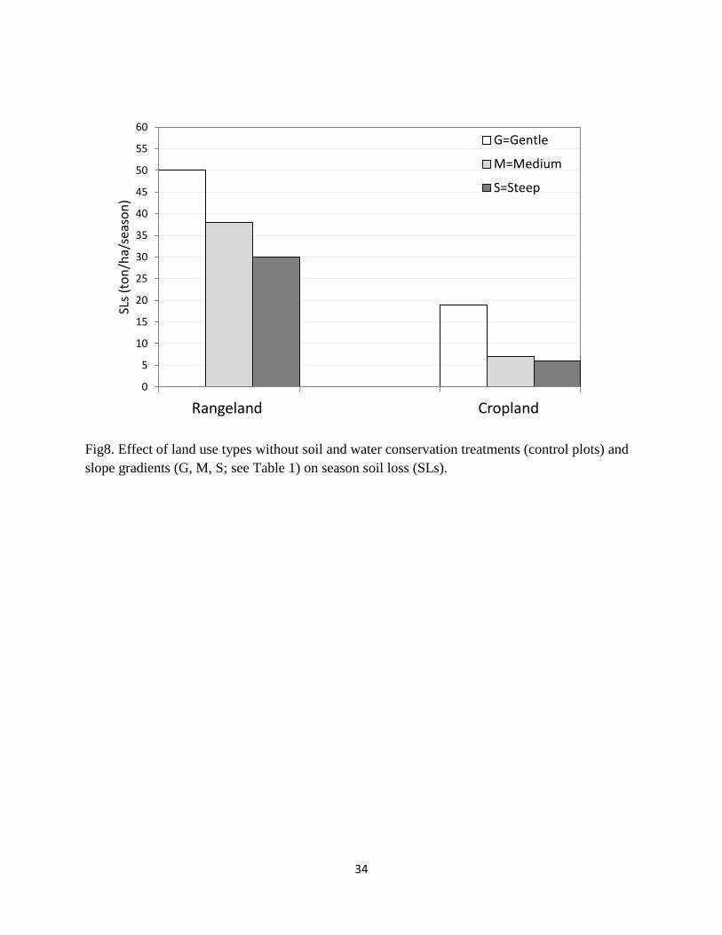
Seasonal soil loss (SLs) was 3 to 5 times higher in rangeland compared to cropland (fig.8).
During the onset of major storms that caused high runoff and soil loss from rangeland plots,
runoff and sediment concentration from cropland plots were low mainly due to tillage. Since the
growing period is very short, cropland plots are drilled after the first two or three storms. Then
the response of the crop to rainfall was rather rapid. Wheat was planted in July and cover
percentage increased from almost no cover to about 30% cover within 2 to 3 weeks time. In
contrast, vegetation recovery in rangeland plots was very slow and these plots were
continuously overgrazed and trampled heavily during the rainy season. Similar to the seasonal
runoff coefficient, seasonal soil loss also decreases with increasing slope gradient. Steep and
medium slope gradients have had less soil loss in both land use types compared to gentle
slope, which was attributed to increasing rock fragment cover with slope gradient (fig.6).
Moreover, soils on the gentle sites of both land use types have strongly expressed vertic
properties. These soils form deep cracks during the dry season and once these cracks are
closed due to swelling after a few storms, they commonly have very low infiltration rates leading
to high runoff response soil loss.
3.2.4. Effects of SWCT on seasonal soil loss
Fig.9 shows SLs values for rangeland and cropland when different SWCT are installed. Similar
to the RCS, SLs was also the lowest for stone bunds with trenches on both land use types.
Compared to SLs from the control plots, the soil loss reduction due to application SWC was
higher in rangeland than in cropland. Stone bunds building lead to soil loss reduction of 58 to
66% in rangeland while the reduction ranges from 43 to 50% in cropland. With SWCT applied,
SLs is decreasing with increasing slope gradient. This is attributed to increasing rock fragment
13
cover (fig.6) which protects the soil surface from direct raindrop impact and hence soil
detachment while favouring soil infiltration on both land uses.
4. Discussion
4.1. Effects of land use and slope gradient on seasonal runoff production
In this study we showed that seasonal runoff production was the highest on rangeland
compared to cropland. Management practices such as soil tillage at the early stages of the
rainy season contributed to increased infiltration rates on cropland leading to lower runoff
responses (fig.5). Rangelands were intensively grazed and compacted and had low vegetation
cover resulting in higher runoff responses. Descheemaeker et al. (2006) also reported higher
daily average RC values of 11.4% to 34.8% for degraded rangeland which was significantly
higher compared to exclosures in Tigray. A study in the central highlands of Ethiopia
(Mwendera and Mohamed, 1997) revealed high RC values of 39 to 72% on event bases at
runoff plot scale on rangeland and attributed this to grazing intensity. In contrast to our findings,
Girmay et al. (2009) indicated a higher RC value (RC=21%) for cropland compared to grazing
land (RC=17%) and Eucalyptus plantation areas (RC=8%) at May leiba catchment. The RC
(21%) is similar to our value of 20% for medium sloping cropland, however, in our study higher
values of RC in rangeland were attributed to very low vegetation cover. Despite the smaller
runoff plots (20m2), compared to our runoff plots (see Table 1), Girmay et al. (2009) found very
low RC values for rangeland. This is not surprising as the vegetation cover of his plots were
63% which is close to the vegetation cover threshold of 65% for runoff production in the study
area (Descheemaeker et al., 2006).
Soil tillage breaks the surface seals and increases the infiltration capacity of the soil (Roa et al.,
1998) although this effect lasts only for a few storms. Bewket and Sterk, (2003) also reported
that tillage creates rough soil surfaces and provides surface storage space and hence reduces
runoff and soil loss. We also observed that when the effects of tillage on infiltration and surface
storage becomes negligible due to rain drop impact, crust development and leveling of the
furrows, crops start growing and provide protection to soil surfaces through interception of
raindrops.
14
In this study we found a decreasing RC with increasing slope gradient (fig.5), which is attributed
to increasing rock fragment cover which also increases with increasing slope gradient (fig.6).
Poesen et al. (1998) also indicated that surface rock fragment cover increases with hillslope
gradient in semiarid Mediterranean environments. Positive effects of rock fragment cover on the
increase of infiltration and surface runoff reduction was also documented (e.g. Poesen et al.,
1990; de Figueiredo and Poesen, 1986; Cerda 2001; Nyssen et al., 2001 and Wang et al.,
2012). In contrast to our finding of the effects of rock fragment cover, Descheemaeker et al.
(2006), attributed differences in plot runoff responses mainly to vegetation cover which
explained 80% of the runoff variability among plots and found no effects of surface rock
fragment cover. Our experimental plots had comparable vegetation cover percentage and soil
moisture conditions both at the beginning and later during the rainy season within each land
use type and differed considerably in surface rock fragment cover. In line with our results
Girmay et al. (2009) and Descheemaeker et al. (2006) also observed a small but negative
correlation between RC and slope gradient in the study area.
4.2. SWCT effects on seasonal runoff production
In this study we observed a strong reduction of the seasonal runoff production when SWCT are
installed. The reduction in seasonal RC is irrespective of the land use types, slope gradients
and type of SWCT installed. All SWCT reduced runoff production though to different levels
compared to the control treatment. While the absolute effect of individual SWCT on RCs is
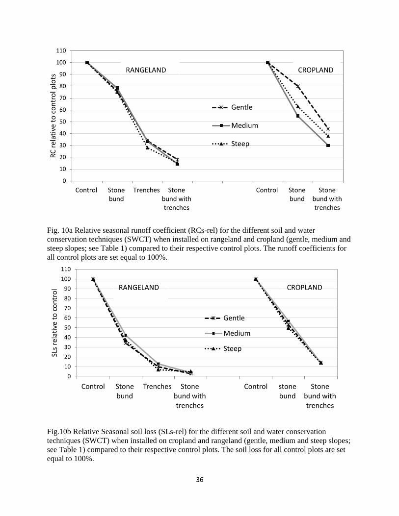
affected by slope gradient (fig.7), the relative effects of SWCT on RCs remain comparable in
rangeland plots (fig.10a). However, in cropland effects of individual SWCT relative to the control
plot on RCs is affected by slope gradient and ranges from 20 to 45% reduction for stone bunds
and 56 to 76% reduction for stone bunds with trenches. In line with our results Lacombe et al.
(2008) found a runoff reduction of 41-50% at catchment scale (993.7 km2) in semi-arid Tunisia
due to the installation of contour ridges and hillside reservoirs to reduce siltation of reservoirs.
Similarly, Hurni et al. (2005) showed a 50% reduction of RC at catchment scale (1.77 km2) after
the introduction of level stone terraces over 80% of a catchment in semi-arid Eretria for
comparable total annual rainfalls before and after the interventions. Dano and Siapno (1992)
found a runoff reduction by 61% relative to a control plot for stone bunds in humid areas of
Philippines. In contrast, small (10%) runoff reduction effects of graded SWC structures (graded
15
fanya juu and graded bunds) was documented for more humid highlands in Ethiopia at runoff
plot scale (Hurni et al., 2005, Herweg and Ludi, 1999).
SWC structures serve as a sink system when installed along the contour in a semi-arid
environment and trap t runoff and sediment which leads to both runoff and soil loss reduction. In
the highlands of Tigray Alemayehu et al. (2009) and Vancampenhout et al. (2006) found that,
due to the retention of surface runoff behind the stone bunds, the top soil on both sides of the
stone bunds has a higher soil moisture content compared to soil moisture content farther away
from the structures. This effect of SWC on soil moisture is even more important at greater soil
depth (1 to 1.5m) (Nyssen et al 2007a). Our field observations also reveal that, after storms
runoff was ponding behind SWC structures while all the runoff from the control plots ended up
in the collector trenches. Due to higher water infiltrating around SWC structures, vegetation
recovery is rather rapid at the onset of the rainy season forming patchy vegetation islands
around SWC structures. A catchment scale (2 km2) study on effects of SWCT (Nyssen et al.,
2010) showed a 81% reduction of RC after implementing SWCT compared to the condition
before catchment management. The same study showed that, due to runoff abstraction by
SWCT, ground water recharge has increased and base flow became perennial.
4.3. Land use and slope effects on soil loss
This study reveals considerable effects of land use type on seasonal soil loss (SLs). On
average SLs in rangeland ( i.e. 39 ton ha-1)) is higher compared to cropland (i.e. SLs 11 ton ha-
1). Higher SLs in rangeland is attributed to higher RC due to intensive grazing and soil
compaction during the rainy season, while soil tillage contributed to lower RC and soil loss in
cropland. In agreement to our results, Nyssen et al. (2009b) found higher soil loss values for
rangeland (17.4 ton ha-1 y-1) compared to that for cropland (9.7 ton ha-1 y-1) at runoff plot scale
in Tigray. During the onset of the rainy season in 2010, soil loss from rangeland plots was
highest, whereas soil loss from cropland plots was very low mainly due to soil tillage.
Depression storage was created by tillage, which retains runoff and reduces sediment
transportation, therefore, soil tillage in cropland reduces soil loss during a critical period i.e. the
period of low vegetation cover. Mwendera and Mohamed, (1997) also found high soil erosion
rates (4.9 mm y-1) from intensively grazed rangeland on 4 to 8% slope gradient at Debre Zeit in
Ethiopia, which results from the removal of vegetation cover and trampling by livestock.
16
Our results reveal that for both land use types, soil loss decreases linearly with increasing slope
gradient which is due to increased rock fragment cover. Surface rock fragment cover reduces
soil detachment and increases infiltration. The effects of slope gradient on soil loss were also
documented to be non-linear (Kapolka and Dollrhopf, 2001) who found soil loss increase with
increasing slope gradient at plot scale from 25 to 40% and a decrease when gradient increased
to 50% in cropland of Montana (USA). The effects of rock fragment cover on soil loss has
been documented (Poesen et al., 1994; Wang et al., 2012). In an area closer to our research
site Nyssen et al. (2001) found that complete removal of rock fragment cover from 20% to 0%
on arable land increases soil flux due to water erosion by threefold. The same study established
linear relationship (R2=0.74) between increasing soil loss as rock fragment cover decreases.
This indicates that rock fragment cover plays an important role in reducing soil erosion rates in
semi arid environment.
4.4. SWCT effects on seasonal soil loss
This study indicates that SWC techniques significantly influence soil loss from plots regardless
of land use types and slope gradients (fig.7). While the effect of individual SWC technique on
soil loss reduction was a function of slope position, the performance of a SWCT relative to their
respective control plots was not affected by slope gradient (fig.10b). Our results showed that
installation of stone bund reduces soil loss by 63% and 47% on average in rangeland and
cropland respectively. Our results are similar to those of Desta et al. (2005) who found a 68%
soil loss reduction due to stone bunds implementation on cropland at farmer’s field scale
(measurements of sediment deposition behind stone bunds in Tigray). On experimental plots
(Dano and Siapno, 1992) found mean soil loss reduction from 28.45 ton ha-1 y-1 on from control
plot to 5.31 ton ha-1 y-1 due to stone bunds. Sediment yield at catchment scale was also found
to be negatively correlated with the fraction of the catchment were SWCT were applied in the
Tigray region (Haregeweyn et al., 2008). This implies that SWC techniques greatly influence
sediment transport processes due to small sediment retention basins created behind SWC
structures (Nyssen et al., 2007a). Nyssen et al. (2009a) found that soil loss at catchment scale
(1.87km2) reduced from 14.3 ton ha-1yr-1 to 9 ton ha-1yr-1 after implementation of physical
SWCT.
17
The soil loss reduction effect of individual SWC treatment is a function of land use type and
slope gradient. Generally, seasonal soil loss is less on cropland compared to rangeland with
similar SWCT applied except for stone bunds with trenches which had a soil loss of 1.5 ton ha-1
for both land use types. Plots treated with stone bunds had a mean seasonal soil loss of 14.6
ton ha-1 in rangeland, while SL from cropland was only 6 ton ha-1. With increasing slope
gradient soil loss become less due to increased rock fragment cover at the soil surface. The
rock fragment cover intercepts direct rainfall which reduces surface sealing and crust
development and thereby soil erosion (Poesen et al., 1990). In addition to surface rock
fragment cover, the rock fragment within the soil profile also increases with slope gradient in the
study area which facilitates infiltration rates. Positive effects of rock fragment content in soil on
infiltration and percolation of water has also been documented in other studies (Zhongjie et al.,
2008), leading to less runoff and soil erosion (Girmay et al., 2009).
5. Conclusions
This study showed that land use type affects both runoff production and soil loss. RCs was 2 to
2.5 times larger in rangeland compared to cropland. Similarly, SLs was 3 to 5 times more in
rangeland compared to cropland. Higher runoff production and soil loss from rangeland is
attributed to intensive grazing and trampling by livestock during the rainy season. Soil tillage
before the main rainy season and increased vegetation cover during the season contributed to
lower seasonal runoff production and soil loss from cropland. On both land use types seasonal
runoff production and soil loss decreased as slope gradient increases (fig.5, 8), which is mainly
due to increasing rock fragment cover which reduces the detaching power of raindrop and
increases infiltration (fig.6). Rock fragment content in the soil profile also increases with
increasing slope gradient. The presence of rock fragments in dominantly clayey soils of the
study area (Table 1) probable facilitated infiltration and percolation of water leading to lower
runoff and soil loss on steeper slopes.
The installation of SWC techniques strongly reduce runoff production and soil loss.
Implementation of stone bunds, trenches and stone bunds with trenches in rangeland led to
RCs reductions by 23, 69 and 84% respectively relative to control plots. In cropland stone
bunds and stone bunds with trenches reduced RCs by 33, 63% respectively relative to control.
Average SLs of 39 ton ha-1 without SWCT was reduced to 14, 4 and 1.5 ton ha-1 after
18
installation of stone bunds, trenches and stone bunds with trenches in rangeland respectively.
Stone bunds and stone bunds with trenches reduced seasonal SL from 11 ton ha-1 without
SWCT to 6 and 1.5 ton ha-1 respectively in cropland. Stone bunds with trenches were the most
effective in reducing runoff production and soil loss for both land use types. Though the effect
individual SWCT on RCs in rangeland was a function of slope gradient (fig.7), the effects of
SWCT relative to their respective control plots remain the same (fig.10a) i.e.irrespective of
slope gradient. However, in cropland both absolute and relative effects of SWCT were different.
This was probably due to interaction effects of vegetation cover and soil management practices
such as tillage in cropland. For each SWCT and land use, RCs and SLs decreased with
increasing slope gradient due to increasing rock fragment cover.
Acknowledgments
We thank the CIUF-CUD project “Improving Water Resource Planning at the Scale of Micro-
dam Catchments in Tigray, Northern Ethiopia: Learning from Success and Failure (WAREP)”
for financial support of this study. We also thank Mekelle University, authorities of Dogu’a
Tenben District, REST (Relief Society of Tigray Dogu’a Temben Branch), Bureau of Water
Resources Development (BoWRD) and local farmers in the study area for their cooperation and
for facilitating fieldwork. Many thanks go to all persons who assisted us during intense storms at
May Leiba, especially Tesfay Tilahun and all guards of the sites for taking care of the plots. We
also appreciate the support of Ato Assefa W/mariam in providing field accommodation for
toTom Goosse
References
Adgo, E., Teshome, A., Mati, B., 2013. Impacts of long-term soil and water conservation on
agricultural productivity: The case of Anjenie watershed, Ethiopia. Agricultural Water
Management 117, 55–61.
Alemayehu, F., Taha, N., Nyssen, J., Girma, A., Amanuel, Z., Mintesinot, B., Deckers, J.,
Poesen, J., 2009. The impacts of watershed management on land use and land cover
19
dynamics in Eastern Tigray (Ethiopia). Resources, Conservation and Recycling 53, 192–
198.
Araya, T., Cornelis, M., Nyssen, J., Govaerts, B., Bauer, H., Gebreegziabher, T., Oicha, T.,
Raes, D., Sayre, D., Mitiku, H., Deckers, J., 2011. Effects of conservation agriculture on
runoff, soil loss and crop yield under rainfed conditions in Tigray, Northern Ethiopia. Soil
Use and Management. 27, 404–414.
Berhane, G., Martens, K., Farrah, N., Walraevens, K., 2013. Water leakage investigation of
micro-dam reservoirs in Mesozoic sedimentary sequences in Northern Ethiopia. Journal
of African Earth Sciences, 79, 98–110.
Bewket, W., 2007. Soil and water conservation intervention with conventional technologies in
northwestern highlands of Ethiopia: Acceptance and adoption by farmers. Land Use
Policy 24, 404–416.
Bewket, W., Sterk, G., 2003. Assessment of soil erosion in cultivated fields using a survey
methodology for rills in the Chemoga watershed, Ethiopia. Agriculture, Ecosystems and
Environment 97, 81–93.
Bewket, W., Teferi, E., 2009. Assessment of soil erosion hazard and prioritization for treatment
at the watershed level: case study in the Chemoga watershed, Blue Nile basin, Ethiopia.
Land Degrad. Develop. 20: 609–622.
BoANR, 2002. Soil and Water Conservation Annual Summary Report (in Tigrigna). Bureau of
Agriculture and Natural Resource Development, Mekelle, Ethiopia.
Cerda, A., 2001. Effects of rock fragment cover on soil infiltration, interrill runoff and erosion.
European Journal of Soil Science 52, 59-68
Dano, M., Siapno, E., 1992. The effectiveness of soil conservation structures in steep cultivated
mountain regions of the Philippines Erosion, Debris flows and Environment in Mountain
Regions (Proceedings of the Chengdu Symposium, July 1992). IAHS Publ. no. 209, 399-
405.

20
de Figueiredo and Poesen 1998. Effect of surface rock fragment characteristics on interrill
runoff and erosion of a silty loam soil. Soil & Tillage Research 46, 81-95.
Descheemaeker, K., Poesen, J., Borselli, L., Nyssen, J., Raes, D., Mitiku, H., Muys, B.,
Deckers, J., 2006. Runoff curve numbers for steep hillslopes with natural vegetation in
semi-arid tropical highlands, northern Ethiopia. Hydrol. Process. 22, 4097–4105.
Desta, G., Nyssen, J., Poesen, J., Deckers, J., Mitiku, H., Govers, G., Moeyersons, J., 2005.
Effectiveness of stone bunds in controlling soil erosion on cropland in the Tigray
Highlands, northern Ethiopia. Soil Use and Management. 21,287-297.
Esser, K., Vigen, T., Tilahun, Y., Mitiku, H., 2002. Soil Conservation in Tigray, Ethiopia:
Noragric Report No. 5. Noragric Aas Norway.
FAO, 2006. Guidline for soil description (4th ED). Rome Itlay.
Garland, C., 1980. Geology of the Adigrat Area. Ministry of Mines, Energy and Water
Resources, Geological survey of Ethiopia, Addis Ababa, 51 pp.
Gebreegziabher, T., Nyssen, J., Govaerts, B., Getnet, F., Behailu, M., Mitiku, H., Deckers, J.,
2009. Contour furrows for in situ soil and water conservation, Tigray, Northern Ethiopia.
Soil & Tillage Research 103, 257–264.
Gebremedhin, B., Swinton, S.M., Tilahun, Y., 1999. Effects of Stone Terraces on Crop yields
and Farm Profitability: Results of On-farm Research in Tigray, Northern Ethiopia. J. Soil
and Water Conservation 54, 568–573.
Gebreyohannes, G., Nyssen, J., Poesen, J., Bauer, H., Merckx, R., Mitiku, H., Deckers, J.,
2012. Land reclamation using reservoir sediments in Tigray, northern Ethiopia. Soil Use
and Management 28, 113–119.
Gee, W., Bauder, W., 1979. Particle Size Analysis by Hydrometer: A Simplified Method for
Routine Textural Analysis and a Sensitivity Test of Measurement Parameters. Soil Sci.
Soc. Am. J.43, 1004–1007.
21
Girmay, G., Singh, R., Nyssen, J., Borrosen, T., 2009. Runoff and sediment-associated nutrient
losses under different land uses in Tigray, Northern Ethiopia. Journal of Hydrology 376,
70–80.
Haileslassie, A., Priess, J., Veldkamp, E., Teketay, D., Lesschen, P., 2005. Assessment of soil
nutrient depletion and its spatial variability on smallholders’ mixed farming systems in
Ethiopia using partial versus full nutrient balances. Agriculture, Ecosystems and
Environment 108, 1–16.
Haregeweyn, N.; Poesen, J.; Nyssen, J.; De Wit, J.; Mitiku Haile; Govers, G.; and Deckers, S.
2006 Reservoirs in Tigray (Northern Ethiopia): Characteristics and Sediment Deposition
Problems. Land Degradation & Development 17: 211–230.
Haregeweyn, N., Poesen, J., Nyssen, J., Govers, G., Verstraeten, G., Vente, J., Deckers, J.,
Moeyersons, J., Mitiku, H., 2008. Sediment yield variability in Northern Ethiopia: A
quantitative analysis of its controlling factors. Catena 75, 65–76.
Herweg, K., Ludi, E., 1999. The performance of selected soil and water conservation
measures—case studies from Ethiopia and Eritrea. Catena 36, 99–114.
Hurni, H., Tato, K., Zeleke, G., 2005. The Implications of Changes in Population, Land Use, and
Land Management for Surface Runoff in the Upper Nile Basin Area of Ethiopia. Mountain
Research and Development Vol 25 No 2: 147–154.
Jennings, S., Brown, N., Sheil, D., 1999. Assessing forest canopies and understorey
illumination: canopy closure, canopy cover and other measures. Forestry 72, 59– 73.
Kapolka, N., Dollhopf, D., 2001. Effect of Slope Gradient and Plant Growth on Soil Loss on
Reconstructed Steep Slopes. International Journal of Surface Mining, Reclamation and
Environment. Vol.15, No. 2, pp.86-99
Lacombe, G., Cappelaere, B., Leduc, C., 2008 Hydrological impact of water and soil
conservation works in the Merguellil catchment of central Tunisia. Journal of Hydrology
359, 210– 224.
22
Mekuria, W., Veldkamp, E., Mitiku, H., Nyssen, J., Muys, B., Gebrehiwot, K. 2007.
Effectiveness of exclosures to restore degraded soils as a result of overgrazing in Tigray,
Ethiopia. Journal of Arid Environments 69, 270–284.
Mitiku.,H,. Herweg K,. Stillhardt, B., (2006): Sustainable Land Management –A New Approach
to Soil and Water Conservation in Ethiopia.-Mekelle University, Mekelle, Ethiopia; Univ.
Berne, Switzerland.
Mwendera, E., Mohamed, S., 1997. Hydrologic response to cattle grazing in the Ethiopian
highlands. Agriculture, Ecosystems and Environment 64, 33-41.
Nyssen, J., Mitiku, H., Poesen, J., Deckers, J., Moeyersons, J., 2001. Removal of rock
fragments and its effect on soil loss and crop yield, Tigray, Ethiopia. Soil Use and
Management 17, 179-187.
Nyssen, J., Poesen, J., Moeyersons, J., Deckers, J., Mitiku, H., Lang, A., 2004. Human impact
on the environment in the Ethiopian and Eritrean highlands—a state of the art. Earth-
Science Reviews, 64, 273–320.
Nyssen, J., Vandenreyken, H., Poesen, J., Moeyersons, J., Deckers, J., Mitiku, H., Salles, C.,
Govers, G., 2005. Rainfall erosivity and variability in the Northern Ethiopian Highlands.
Journal of Hydrology 311, 172-178.
Nyssen, J., Poesen, J., Desta, G., Vancampenhout, K., D’aes, M., Yihdego, G., Govers, G.,
Leirs, H., Moeyersons, J., Naudts, J., Haregeweyn, N., Mitiku, H., Deckers, J., 2007a.
Interdisciplinary on-site evaluation of stone bunds to control soil erosion on cropland in
Northern Ethiopia. Soil & Tillage Research 94, 151–163.
Nyssen, J., Descheemaeker, K., Haregeweyn, N., Mitiku, H., Deckers, J., Poesen, J. (eds.).
2007b. Lessons learnt from 10 years research on soil erosion and soil and water
conservation in Tigray. Tigray Livelihood Papers No. 7, Mekelle: Zala-Daget Project,
Mekelle University, K.U.Leuven, Relief Society of Tigray, Africamuseum and Tigray
Bureau of Agriculture and Rural Development, 53 p. ISBN 978-90-8826-027-8.

23
Nyssen, J., Poesen, J,. Descheemaeker, K,. Haregeweyn, N., Mitiku, H,. Moeyersons, J,.
Frankl, A., Govers, J., Munro, N., Deckers, J., 2008. Effects of region-wide soil and water
conservationin semi-arid areas: the case of northern Ethiopia. Z. Geomorph. N.
F.52:291-315.
Nyssen J., Clymans W., Poesen J., Vandecasteele, I., De Baets, S., Haregeweyn, N.,
Naudts, J., Hadera, A., Moeyersons, J., Mitiku, H., Deckers, J., 2009a. How Soil
Conservation Affects the Catchment Sediment Budget – a Comprehensive Study in the
North Ethiopian Highlands. Earth Surf. Process. Landforms 34, 1216–1233.
Nyssen, J., Poesen, J., Mitiku, H., Moeyersons, J., Deckers, J., and Hurni, H., 2009b. Effects
of land use and land cover on sheet and rill erosion rates in the Tigray highlands,
Ethiopia. Z. Geomorph. N. F.Vol. 53 (2), 171-197.
Nyssen, J., Clymans, W., Descheemaeker, K., Poesen, J., Vandecasteele, I., Vanmaercke, M.,
Amanuel, Z., Van Camp, M., Mitiku, H., Haregeweyn, N., Moeyersons, J., Martens, K.,
Gebreyohannes, T., Deckers, J., Walraevens, K., 2010. Impact of soil and water
conservation measures on catchment hydrological response—a case in north Ethiopia.
Hydrol. Process. 24, 1880–1895.
Osman, M., Petra, S., 2001. Soil and Water Conservation in Ethiopia: Experiences and
Lessons J Soils & Sediments 1 (2) 117 - 123.
Poesen, J., 1986. Surface sealing as influenced by slope angle and position of simulated
stones in the top layer of loose sediments. Earth Surface Processes and Landforms, Vol.
11, 1-10.
Poesen, J., Ingelmo-Sanchez, F. and Mücher, H. 1990. The hydrological response of soil
surfaces to rainfall as affected by cover and position of rock fragments in the toplayer.
Earth Surface Processes and Landforms, Vol. 15, 653-671.
Poesen, J., Torri, D. and Bunte, K. 1994. Effects of rock fragments on soil erosion by water at
different spatial scales: a review. Catena 23:141-166.
24
Poesen, J., Wesemael, B., Bunte, K., Benet, A., 1998. Variation of rock fragment cover and size
along semiarid hillslopes: a case-study from southeast Spain. Geomorphology 23, 323–
335.
Rao, P., Steenhuisb, S., Coglec, L., Srinivasana, T., Yulec, F., Smithc, D., (1998): Rainfall
infiltration and runoff from an Alfisol in semi-arid tropical India. II. Tilled systems1. Soil &
Tillage Research 48, 61-69.
Shiferaw, B., Holden, S., 1999. Soil Erosion and Smallholders' Conservation Decisions in the
Highlands of Ethiopia. World Development Vol. 27, No. 4, pp. 739-752.
Tamene, L., Park, J., Dikau, R., Vlek, L., 2006. Analysis of factors determining sediment yield
variability in the highlands of northern Ethiopia Geomorphology 76, 76– 91.
Tulema, B., Jens, A., Johnsen, F., Vanlauwe, B. 2008. The prospects of reduced tillage in tef
(Eragrostis tef Zucca) in Gare Arera, West Shawa Zone of Oromiya, Ethiopia. Soil &
Tillage Research 99, 58–65.
Torri, D., Poesen, J., Monaci, F., Busoni, E., 1994. Rock fragment content and fine soil bulk
density. Catena 23, 65-71.
Vancampenhout, K., Nyssen, J., Desta, G., Deckers, J., Poesen, J., Mitiku, H., Moeyersons, J.,
2006. Stone Bunds for Soil Conservation in the Northern Ethiopian Highlands: Impacts
on Soil Fertility and Crop Yield. Soil & Tillage Research 90, 1–15.
Van de Wauw J., Baert G., Moeyersons J., Nyssen J., De Geyndt K., Nurhussein Taha,
Amanuel Zenebe, Poesen J. and Deckers J. 2008. Soil–landscape Relationships in the
Basalt-dominated Highlands of Tigray, Ethiopia, Catena 75, 117–127.
Virgo, J., Munro, N., 1978. Soil and erosion features of the central plateaux of Tigray, Ethiopia.
Geoderma, 20, 131– 157.
Walkley, A., Black, C.A., 1934. Estimationof organic carbon by chromic acid titration method.
Soil Sci. 37, 29–38.

25
Wang, X., Li, Z., Cia, C., Shi, Z., Xu, Q., Fu, Z., Guo, Z., 2012. Effects of rock fragment cover
on hydrological response and soil loss from Regosols in a semi-humid environment in
South-West China. Geomorphology 151-152, 234–242.
Welderufael, A., Le Roux, A., Hensley, M., 2008. Quantifying rainfall–runoff relationships on the
Dera Calcic Fluvic Regosol ecotope in Ethiopia. Agricultural water management,.95
1223-1232.
Zhongjie, S., Yanhui, W., Pengtao, Y., Lihong, X., Wei, X., Hao, H., 2008. Effect of rock
fragments on the percolation and evaporation of forest soil in Liupan Mountains, China.
Acta Ecologica Sinica, 28(12), 6090-6098.
26
Tables and figures
Table 1. Plot treatments, spacing of soil and water conservation structures (SWC), SWC structures per plot, plot dimensions, slope gradient,
soil types, and mean values of surface and soil characteristics. NA: is not applicable, Bulk density of the 10cm thick top soil.
Land
use
Treatments Spacing of
SWC
structures(m)
Number of
SWC
structures
per plot
Plot
dimensions
(mxm)
Slope
gradient
(%)
Soil type Soil
texture
Rock fragment
cover Rfc (%)
Organic
carbon
(%)
Bulk
density
(g/cm3)
Control NA NA 60X10 5
5
5
5
Cambic vertisols Clay 8 1.7 1.3
Stone bund 20 3 60X10 Cambic vertisols Clay 6 1.8 1.4
Trench 20 3 60X10 Cambic vertisols Clay 7 2.2 1.5
Stone bund with trench 20 3 60X10 Cambic vertisols Clay 9 1.9 1.5
Control NA NA 60x10 12
12
12
12
Calcaric cambisols Clay loam 23 1.1 1.4
Stone bund 12 5 60X10 Calcaric cambisols Clay loam 33 0.7 1.5
Trench 12 5 60X10 Calcaric cambisols Clay loam 20 1.5 1.3
Stone bund with trench 12 5 60X10 Calcaric cambisols Clay loam 26 2.0 1.4
Control NA NA 63X10 16
16
16
16
Calcaric vertisols Clay 38 2.1 1.6
Stone bund 9 7 63X10 Calcaric vertisols Clay 37 2.1 1.6
Trench 9 7 63X10 Calcaric vertisols Clay 29 2.1 1.4
Stone bund with trench 9 7 63X10 Calcaric vertisols Clay 30 2.2 1.5
Ran
gela
nd
(R
L)
27
Control NA NA 100X10 5
5
5
Vertisols Clay 6 0.8 1.0
Stone bund 20 5 100X10 Vertisols Clay 5 0.9 1.2
Stone bund with trench 20 5 100X10 Vertisols Clay 4 0.8 1.1
Control NA NA 91X10 12
12
12
Vertic cambisols clay loam 19 0.4 1.1
Stone bund 13 7 91X10 Vertic cambisols Clay loam 20 0.5 1.0
Stone bund with trench 13 7 91X10 Vertic cambisols Clay loam 22 0.7 1.1
Control NA NA 77X10 16
16
16
Skeletic cambisols Clay loam 25 0.6 1.0
Stone bund 11 7 77X10 skeletic cambisols Clay loam 28 0.4 1.2
Stone bund with trench 11 7 77X10 Skeletic cambisols Clay loam 26 0.6 1.3
C
rop
lan
d
(CL)
28
Fig.1 Location of the study area: a) Ethiopia; b) Tigray region in north Ethiopia with districts; c)
May Leiba catchment.
a
b
c
29
a b
C d
Fig. 2a Runoff plots (width=10m; length=63m) to evaluate effects of soil and water conservation
techniques (SWCT) in rangeland on a steep slope (gradient 16%) a) control, b) stone bunds c)
trenches and d) stone bunds with trenches (May Leiba; 27 July 2010).
30
a b
c
Fig. 2b Runoff plots (width=10m; length=91m) to evaluate effects of soil and water conservation
techniques (SWCT) in cropland on a medium slope (gradient 12%) a) control, b) stone bunds, c)
stone bunds with trenches (May Leba; 27 July 2010).
31
Fig. 3 Topographic map (in m.a.s.l.) of two plot-measuring sites on a medium slope (both 12%)
RL-M; rangeland medium slope site with four runoff plots and CL-M; cropland medium slope
site with three runoff plots.
Fig. 4 Mean (n=3 rain gauges) monthly rainfall depth (Prm) in 2010 at May Leiba compared to
long-term (15 y: 1996 to 2010) average Prm at Hagere Selam, 10km south west from May
Leiba.
0
50
100
150
200
250
Jan. Feb. Mar. Apr. May Jun. Jul. Aug. Sep. Oct. Nov. Dec.
Prm
(m
m)
Mean long-term (15 y) Prm
Mean Prm in 2010
RL-M CL-M CL-M
32
Fig. 5Effects of land use types without soil and water conservation treatments (control plots) and
slope gradients (G, M, S; see Table 1) on seasonal runoff coefficient (RCs) when all rainfall
events (also those that did not generate runoff) are included: Seasonal rainfall depth (Prs) in 2010
for rangeland ranges from 321 to 357mm; Prs for cropland ranges from 306 to 335mm.
0
0.1
0.2
0.3
0.4
0.5
0.6 R
Cs
Rangeland Cropland
G=Gentle
M=Medium
S=Steep
0
5
10
15
20
25
30
35
40
0 5 10 15 20
Rfc
(%
)
Slope (%)
Rangeland
Cropland
33
Fig. 6 Relation between slope gradient and mean rock fragment (>5mm in diameter) cover (Rfc)
on cropland and rangeland.
Fig. 7 Effects SWC treatments on seasonal runoff coefficient (RCs) for rangeland and cropland.
Season in this case covers 66% of the total annual rainfall.
0
0.1
0.2
0.3
0.4
0.5
0.6
Control Stone bund
Trenches Stone bund with trenches
Control Stone bund
Stone bund with trenches
RC
s
Gentle
Medium
Steep
RANGELAND CROPLAND
34
Fig8. Effect of land use types without soil and water conservation treatments (control plots) and
slope gradients (G, M, S; see Table 1) on season soil loss (SLs).
0
5
10
15
20
25
30
35
40
45
50
55
60
Rangeland Cropland
SLs
(to
n/h
a/se
aso
n)
G=Gentle
M=Medium
S=Steep
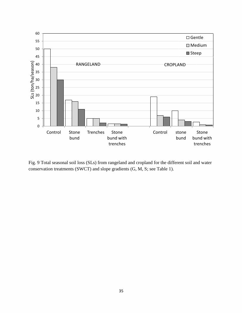
35
Fig. 9 Total seasonal soil loss (SLs) from rangeland and cropland for the different soil and water
conservation treatments (SWCT) and slope gradients (G, M, S; see Table 1).
0
5
10
15
20
25
30
35
40
45
50
55
60
Control Stone bund
Trenches Stone bund with trenches
Control stone bund
Stone bund with trenches
SLs
(to
n/h
a/se
aso
n)
Gentle
Medium
Steep
RANGELAND CROPLAND
36
Fig. 10a Relative seasonal runoff coefficient (RCs-rel) for the different soil and water
conservation techniques (SWCT) when installed on rangeland and cropland (gentle, medium and
steep slopes; see Table 1) compared to their respective control plots. The runoff coefficients for
all control plots are set equal to 100%.
Fig.10b Relative Seasonal soil loss (SLs-rel) for the different soil and water conservation
techniques (SWCT) when installed on cropland and rangeland (gentle, medium and steep slopes;
see Table 1) compared to their respective control plots. The soil loss for all control plots are set
equal to 100%.
0
10
20
30
40
50
60
70
80
90
100
110
Control Stone bund
Trenches Stone bund with trenches
Control Stone bund
Stone bund with trenches
RC
rel
ativ
e to
co
ntr
ol p
lots
Gentle
Medium
Steep
0
10
20
30
40
50
60
70
80
90
100
110
Control Stone bund
Trenches Stone bund with trenches
Control stone bund
Stone bund with trenches
SLs
rela
tive
to
co
ntr
ol
Gentle
Medium
Steep
RANGELAND CROPLAND
RANGELAND CROPLAND