residual total magnetic field composante … · composante rÉsiduelle du champ magnÉtique total...

1
552000 E 552000 E 554000 E 554000 E 556000 E 556000 E 558000 E 558000 E 560000 E 560000 E 562000 E 562000 E 564000 E 564000 E 566000 E 566000 E 568000 E 568000 E 570000 E 570000 E 572000 E 572000 E 574000 E 574000 E 576000 E 576000 E 578000 E 578000 E 5460000 N 5460000 N 5462000 N 5462000 N 5464000 N 5464000 N 5466000 N 5466000 N 5468000 N 5468000 N 5470000 N 5470000 N 5472000 N 5472000 N 5474000 N 5474000 N 5476000 N 5476000 N 5478000 N 5478000 N N 49°20 N 49°25 N 49°20 N 49°25 W 56°15 W 56°10 W 56°05 W 56°00 W 56°15 W 56°10 W 56°05 W 56°00 Moose Brook Wigwam Cove White Point Halls Bay Dock Point Moose Brook Rocky Pond Tommy's Arm River Loon Brook Loon Pond Loon Brook Beothuk Trail Tommy's Arm River Rocky Pond West Brook West Pond Hill Aspen Brook Aspen Brook West Pond Underground Brook Saunders Brook Johnson Lookout Barneys Brook Moose Pond Underground Brook Barneys Brook Riverhead Brook Upper Burnt Berry Pond South Brook Salmon Brook Trans-Canada Highway Wolf Head West Bottom Eaton Point South Pond Sugarloaf Hill South Brook Wolf Cove Beothuk Trail Spring Cove Green Point Burnt Berry Brook Long Steady Pond Hall Hill Rowsell Hill Burnt Berry Pond Barneys Hill Boot Harbour (Second) Pond Anthony Pond Gummy Brook Gummy Pond Boot Harbour Pond Sandy Pond Deer Pond Spot Pond Rocky Pond Island Pond Brook Wellmans Brook Fourth Pond South Brook Island Pond Black Brook Silver Brook Ghost Pond Ski Pond Fox Pond Gummy Brook South Brook North Twin Lake Topographic contour interval 50 feet Topographic contour interval 10 metres GEOPHYSICAL SERIES RESIDUAL TOTAL MAGNETIC FIELD SÉRIE GÉOPHYSIQUE COMPOSANTE RÉSIDUELLE DU CHAMP MAGNÉTIQUE TOTAL GEOLOGICAL SURVEY OF CANADA COMMISSION GÉOLOGIQUE DU CANADA LOCATION MAP - CARTE DE LOCALISATION Scale 1:25 000 - Échelle 1/25 000 1 0.5 0 0.5 Kilometres Kilomètres 2 1.5 Projection transverse universelle de Mercator Système de référence géodesique nord-americain, 1983 © Sa Majesté la Reine du chef du Canada 2007 Universal Transverse Mercator Projection North American Datum 1983 © Her Majesty the Queen in Right of Canada 2007 NAD 83 / UTM Zone 21N Digital Topographic Data provided by Geomatics Canada, Natural Resources Canada Données topographiques numériques de Géomatique Canada, Ressources naturelles Canada GULLBRIDGE AEROMAGNETIC SURVEY LEVÉ AÉROMAGNÉTIQUE DE GULLBRIDGE Open files are products that have not gone through the GSC formal publication process. Les dossiers publics sont des produits qui n’ont pas été soumis au processus officiel de publication de la CGC. OPEN FILE DOSSIER PUBLIC GEOLOGICAL SURVEY OF CANADA COMMISSION GÉOLOGIQUE DU CANADA 5651 2007 NATIONAL TOPOGRAPHICAL SYSTEM REFERENCE AND GEOPHYSICAL MAP INDEX SYSTÈME NATIONAL DE RÉFÉRENCE CARTOGRAPHIQUE ET INDEX DES CARTES GÉOPHYSIQUES Railway Drainage Topographic contour Planimetric Symbols Roads RESIDUAL TOTAL MAGNETIC FIELD COMPOSANTE RÉSIDUELLE DU CHAMP MAGNÉTIQUE TOTAL Symboles Planimétriques Chemin de fer Drainage Courbe de niveau Chemin Residual total magnetic field, Gullbridge Aeromagnetic Survey; Newfoundland and Labrador, Parts of NTS 12 H/8 and 2 E/5; Geological Survey of Canada, Open File 5651, Newfoundland and Labrador Department of Natural Resources, Geological Survey Open File NFLD/2953, Scale 1:25 000. Composante résiduelle du champ magnétique total, Levé aéromagnétique de Gullbridge, Terre-Neuve-et-Labrador, Parties des SNRC 12 H/8 et 2 E/5; Commission géologique du Canada, Dossier public 5651, Newfoundland and Labrador Department of Natural Resources, Geological Survey Open File NFLD/2953, échelle 1/25 000. 2E/5 12H/1 12H/8 12A/16 12A/15 12H/2 2E/4 12H/7 2E/12 12H/9 12H/10 2D/13 55°30'W 48°45'N 55°30'W 49°45'N 57°00'W 49°45'N 57°00'W 48°45'N 49°00'N 49°00'N 56°00'W 56°30'W 56°00'W 56°30'W 49°15N 49°30'N 49°15'N 49°30'N Springdale South Brook Grand Falls Windsor GSC OF 5651 Newfoundland and Labrador Department of Natural Resources, Geological Survey Open File NFLD/2953 PARTS OF NTS 12 H/8 and 2 E/5 / PARTIES DES SNRC 12 H/8 et 2 E/5 GSC OPEN FILE 5651 / DOSSIER PUBLIC 5651 DE LA CGC Newfoundland and Labrador / Terre-Neuve-et-Labrador NEWFOUNDLAND AND LABRADOR DEPARTMENT OF NATURAL RESOURCES, GEOLOGICAL SURVEY OPEN FILE NFLD/2953 NFLD/2953 GSC OF 5650 012H/1813 GSC OF 5649 NFLD/2952 GSC OF 5647 012A/1239 GSC OF 5648 NFLD/2951 This 3 airborne geophysical survey and the production of this map were funded by Natural Resources Canada Targeted Geoscience Initiative (TGI-3) TGI-3 and by the Geological Survey, Newfoundland and Labrador Department of Natural Resources. This map is a contribution to the Program of the Earth Sciences Sector. Ce de levé géophysique aéroporté et la production de cette carte ont été financés par le programme de l'Initiative géoscientifique ciblée (IGC-3) Ressources contribue naturelles Canada et par le Geological Survey, Newfoundland and Labrador Department of Natural Resources. Cette carte au programme IGC-3 du Secteur des sciences de la Terre. Authors: Dumont, R. and Potvin, J. Data acquisition, compilation and map production by Fugro Airborne Surveys, Toronto, Ontario. Contract and project management by the Geological Survey of Canada, Ottawa, Ontario. Auteurs: Dumont, R. et Potvin, J. L'acquisition, la compilation des données ainsi que la production des cartes furent effectuées par Fugro Airborne Surveys, Toronto, Ontario. La gestion et la supervision du projet furent effectuées par la Commission géologique du Canada, Ottawa, Ontario. This survey map of the residual total magnetic field was compiled from data acquired during a horizontal gradient aeromagnetic conducted data by Fugro Airborne Surveys using a MIDAS helicopter-borne system during the period March 1 to March 27, 2007. The were a recorded using two split-beam cesium vapour magnetometers (sensitivity = 0.005 nT) with a 13.4 m separation mounted on horizontal m boom assembly on an AS350BA helicopter(C-GJIX). The nominal traverse and control line spacings were, respectively, 100 and lines. 500 m, and the aircraft flew at a nominal terrain clearance of 40 m. Traverse lines were oriented N60°W orthogonal to control The of flight path was recovered following post-flight differential corrections to the raw Global Positioning System data and inspection ground and images recorded by a vertically-mounted video camera. The differences in magnetic values at the intersections of control traverse then lines were computer-analysed to obtain a mutually levelled set of flight-line magnetic data. The levelled values were interpolated Geomagnetic to a 20 m grid using a process that incorporated the measured horizontal gradient data. The International Reference the Field (IGRF) defined at an altitude of 215 m for the year 2007.25 was then removed. Removal of the IGRF, representing magnetic field of the Earth's core, produces a residual component related essentially to magnetizations within the Earth's crust. Residual Total Magnetic Field Digital (MIRAGE) versions of this map, can be downloaded, at no charge, from Natural Resources Canada's Geoscience Data Repository at Geological http://gdr.nrcan.gc.ca, from the Newfoundland and Labrador Resource Atlas (http://gis.geosurv.gov.nl.ca/), and from the Survey http://www.nr.gov.nl.ca/mines&en/geosurvey/publications/openfiles/. of Newfoundland and Labrador On-Line Open File page Corresponding the digital profile and gridded data as well as similar data for adjacent airborne geophysical surveys are available from Geoscience the Data Repository (Aeromagnetic Data) (http://gdr.nrcan.gc.ca). The same products are also available, for a fee, from Geophysical 995-5326, Data Centre, Geological Survey of Canada, 615 Booth Street, Ottawa, Ontario, K1A 0E9. Telephone: (613) email:[email protected]. Cette levé carte de la composante résiduelle du champ magnétique total a été compilée à partir de données acquises lors d'un héliporté MIDAS, mesurant le gradient magnétique horizontal exécuté par la société Fugro Airborne Surveys en utilisant leur système pendant à la période du 1er au 27 mars 2007. Les données ont été recueillies au moyen de deux magnétomètres à vapeur de césium faisceau un partagé (sensibilité de 0,005 nT) installés aux extrémités d'une poutrelle horizontale avec un séparation de 13.4 m sur hélicoptère m. AS350BA (C-GJIX). L'espacement nominal des lignes de vol était de 100 m et celui des lignes de contrôle, de 500 L'aéronef aux volait à une hauteur nominale au dessus du sol de 40 m. Les lignes de vol étaient orientées N 60°O, perpendiculairement lignes du de contrôle. La trajectoire de vol a été restituée par l'application après le vol de corrections différentielles aux données brutes système des GPS et par inspection d'images du sol enregistrées au moyen d'une caméra vidéo installée à la verticale. Les différences valeurs un du champ magnétique aux intersections des lignes de contrôle et des traverses ont été analysées par ordinateur afin d'obtenir jeu en de données nivelées sur le champ magnétique le long de la ligne de vol. Ces valeurs nivelées ont ensuite été interpolées incorporant Le les données du gradient horizontal mesuré dans le processus du calcul de la maille suivant un quadrillage de 20 m. champ La géomagnétique international de référence (IGRF) défini à une altitude de 215 m pour l'année 2007.25 a été soustrait. soustraction reliée du IGRF, qui représente le champ magnétique du noyau terrestre, fournit une composante résiduelle essentiellement à l'aimantation de la croûte terrestre. Composante résiduelle du champ magnétique total On données peut télécharger gratuitement, des versions numériques de cette carte, depuis la section sur MIRAGE de l'Entrepôt de géoscientifiques Labrador de Ressources naturelles Canada à l'adresse Web http://edg.rncan.gc.ca ainsi qu'au Newfoundland and Resource Labrador Atlas (http://gis.geosurv.gov.nl.ca/) et au site-web On-Line Open File du Geological Survey of Newfoundland and (http://www.nr.gov.nl.ca/mines&en/geosurvey/publications/openfiles/). et Les données numériques correspondantes en formats profil maille données ainsi que des données similaires issues des levés géophysiques aéroportés adjacents sont disponibles de l'Entrepôt de géoscientifiques se de Ressources naturelles Canada (Données aéromagnétiques) à l'adresse Web http://edg.rncan.gc.ca On peut procurer géologique les mêmes produits, moyennant des frais, en s'adressant au Centre de données géophysiques de la Commission du Canada, 615, rue Booth, Ottawa (Ontario) K1A 0E9, Tél : (613) 995-5326, courriel : [email protected]. GULLBRIDGE AEROMAGNETIC SURVEY LEVÉ AÉROMAGNÉTIQUE DE GULLBRIDGE Newfoundland and Labrador / Terre-Neuve-et-Labrador GSC OF 5650 012H/1813 Recommended citation: Dumont, R. and Potvin, J. 2007: Notation bibliographique conseillée : Dumont, R. et Potvin, J. 2007 : -550 -500 -480 -460 -440 -420 -410 -400 -390 -380 -370 -360 -350 -340 -330 -320 -310 -300 -290 -280 -270 -260 -250 -240 -230 -220 -210 -200 -190 -180 -170 -160 -150 -140 -130 -120 -110 -100 -90 -80 -70 -60 -50 -40 -30 -25 -20 -15 -10 -5 0 5 10 15 20 25 30 40 50 60 70 80 90 100 110 120 130 140 150 160 170 180 200 220 240 260 280 300 320 340 360 400 450 500 600 800 nT

Upload: dokhue

Post on 10-Sep-2018

217 views

Category:

Documents


0 download

TRANSCRIPT

552000 E

552000 E

554000 E

554000 E

556000 E

556000 E

558000 E

558000 E

560000 E

560000 E

562000 E

562000 E

564000 E

564000 E

566000 E

566000 E

568000 E

568000 E

570000 E

570000 E

572000 E

572000 E

574000 E

574000 E

576000 E

576000 E

578000 E

578000 E

54

60

00

0 N

54

60

00

0 N

54

62

00

0 N

54

62

00

0 N

54

64

00

0 N

54

64

00

0 N

54

66

00

0 N

54

66

00

0 N

54

68

00

0 N

54

68

00

0 N

54

70

00

0 N

54

70

00

0 N

54

72

00

0 N

54

72

00

0 N

54

74

00

0 N

54

74

00

0 N

54

76

00

0 N

54

76

00

0 N

54

78

00

0 N

54

78

00

0 N

N 4

9°2

0N

49

°25

N 4

9°2

0N

49

°25

W 56°15 W 56°10 W 56°05 W 56°00

W 56°15 W 56°10 W 56°05 W 56°00

Moose Brook

Wigwam Cove

White Point

Halls Bay

Dock Point

Moose Brook

Rocky Pond

Tommy's Arm River

Loon Brook

Loon Pond

Loon Brook

Beothuk Trail

Tommy's Arm River

Rocky Pond

West Brook West Pond Hill

Aspen Brook

Aspen Brook

West Pond

Underground BrookSaunders Brook

Johnson Lookout

Barneys Brook

Moose Pond

Underground Brook

Barneys Brook

Riverhead Brook

Upper Burnt Berry Pond

South Brook

Salmon Brook

Trans-Canada Highway

Wolf HeadWest Bottom

Eaton Point

South Pond

Sugarloaf Hill

South Brook

Wolf Cove

Beothuk Trail

Spring Cove

Green Point

Burnt Berry Brook

Long Steady Pond

Hall Hill

Rowsell Hill

Burnt Berry Pond

Barneys Hill

Boot Harbour (Second) Pond

Anthony Pond

Gummy Brook

Gummy Pond

Boot Harbour Pond

Sandy Pond

Deer Pond

Spot Pond

Rocky Pond

Island Pond Brook

Wellmans Brook

Fourth Pond

South Brook

Island Pond

Black Brook

Silver Brook

Ghost Pond

Ski Pond

Fox Pond

Gummy Brook

South Brook

North Twin Lake

Topographic contour interval 50 feetTopographic contour interval 10 metres

GEOPHYSICAL SERIESRESIDUAL TOTAL MAGNETIC FIELD

SÉRIE GÉOPHYSIQUECOMPOSANTE RÉSIDUELLE DU CHAMP MAGNÉTIQUE TOTAL

GEOLOGICAL SURVEY OF CANADA COMMISSION GÉOLOGIQUE DU CANADA

LOCATION MAP - CARTE DE LOCALISATION

Scale 1:25 000 - Échelle 1/25 00010.500.5Kilometres Kilomètres21.5

Projection transverse universelle de MercatorSystème de référence géodesique nord-americain, 1983

© Sa Majesté la Reine du chef du Canada 2007

Universal Transverse Mercator ProjectionNorth American Datum 1983

© Her Majesty the Queen in Right of Canada 2007

NAD 83 / UTM Zone 21NDigital Topographic Data provided by Geomatics Canada, Natural Resources Canada

Données topographiques numériques de Géomatique Canada, Ressources naturelles CanadaGULLBRIDGE AEROMAGNETIC SURVEYLEVÉ AÉROMAGNÉTIQUE DE GULLBRIDGE

Open files are productsthat have not gonethrough the GSC formalpublication process.

Les dossiers publics sont des produits qui n’ont pas été soumis au processus officiel de publication de la CGC.

OPEN FILEDOSSIER PUBLIC

GEOLOGICAL SURVEY OF CANADACOMMISSION GÉOLOGIQUE DU CANADA

5651

2007

NATIONAL TOPOGRAPHICAL SYSTEM REFERENCE AND GEOPHYSICAL MAP INDEX

SYSTÈME NATIONAL DE RÉFÉRENCE CARTOGRAPHIQUE ET INDEX DES CARTES GÉOPHYSIQUES

Railway

Drainage

Topographic contour

Planimetric Symbols

Roads

RESIDUAL TOTAL MAGNETIC FIELD

COMPOSANTE RÉSIDUELLE DU CHAMP MAGNÉTIQUE TOTAL

Symboles Planimétriques

Chemin de fer

Drainage

Courbe de niveau

Chemin

Residual total magnetic field,Gullbridge Aeromagnetic Survey; Newfoundland and Labrador,Parts of NTS 12 H/8 and 2 E/5;Geological Survey of Canada, Open File 5651,Newfoundland and Labrador Department of Natural Resources,Geological Survey Open File NFLD/2953,Scale 1:25 000.

Composante résiduelle du champ magnétique total,Levé aéromagnétique de Gullbridge, Terre-Neuve-et-Labrador,Parties des SNRC 12 H/8 et 2 E/5;Commission géologique du Canada, Dossier public 5651,Newfoundland and Labrador Department of Natural Resources,Geological Survey Open File NFLD/2953,échelle 1/25 000.

2E/5

12H/1

12H/8

12A/1612A/15

12H/2 2E/4

12H/7

2E/1212H/912H/10

2D/13

55°30'W48°45'N

55°30'W49°45'N

57°00'W49°45'N

57°00'W48°45'N

49°00'N49°00'N

56°00'W56°30'W

56°00'W56°30'W

49°15N

49°30'N

49°15'N

49°30'N

Springdale

South Brook

Grand Falls

Windsor

GSC OF 5651

Newfoundland and Labrador Department of NaturalResources, Geological Survey Open File NFLD/2953

PARTS OF NTS 12 H/8 and 2 E/5 / PARTIES DES SNRC 12 H/8 et 2 E/5

GSC OPEN FILE 5651 / DOSSIER PUBLIC 5651 DE LA CGC

Newfoundland and Labrador / Terre-Neuve-et-Labrador

NEWFOUNDLAND AND LABRADOR DEPARTMENT OF NATURAL RESOURCES, GEOLOGICAL SURVEY OPEN FILE NFLD/2953

NFLD/2953

GSC OF 5650

012H/1813

GSC OF 5649

NFLD/2952

GSC OF 5647

012A/1239

GSC OF 5648

NFLD/2951

This 3airborne geophysical survey and the production of this map were funded by Natural Resources Canada Targeted Geoscience Initiative (TGI-3) TGI-3and by the Geological Survey, Newfoundland and Labrador Department of Natural Resources. This map is a contribution to the Program of the Earth Sciences Sector.Ce delevé géophysique aéroporté et la production de cette carte ont été financés par le programme de l'Initiative géoscientifique ciblée (IGC-3) Ressources contribuenaturelles Canada et par le Geological Survey, Newfoundland and Labrador Department of Natural Resources. Cette carte au programme IGC-3 du Secteur des sciences de la Terre.

Authors: Dumont, R. and Potvin, J.

Data acquisition, compilation and map production by

Fugro Airborne Surveys, Toronto, Ontario.

Contract and project management

by the Geological Survey of Canada, Ottawa, Ontario.

Auteurs: Dumont, R. et Potvin, J.

L'acquisition, la compilation des données ainsi que la production des cartes furent

effectuées par Fugro Airborne Surveys, Toronto, Ontario.

La gestion et la supervision du projet furent effectuées

par la Commission géologique du Canada, Ottawa, Ontario.

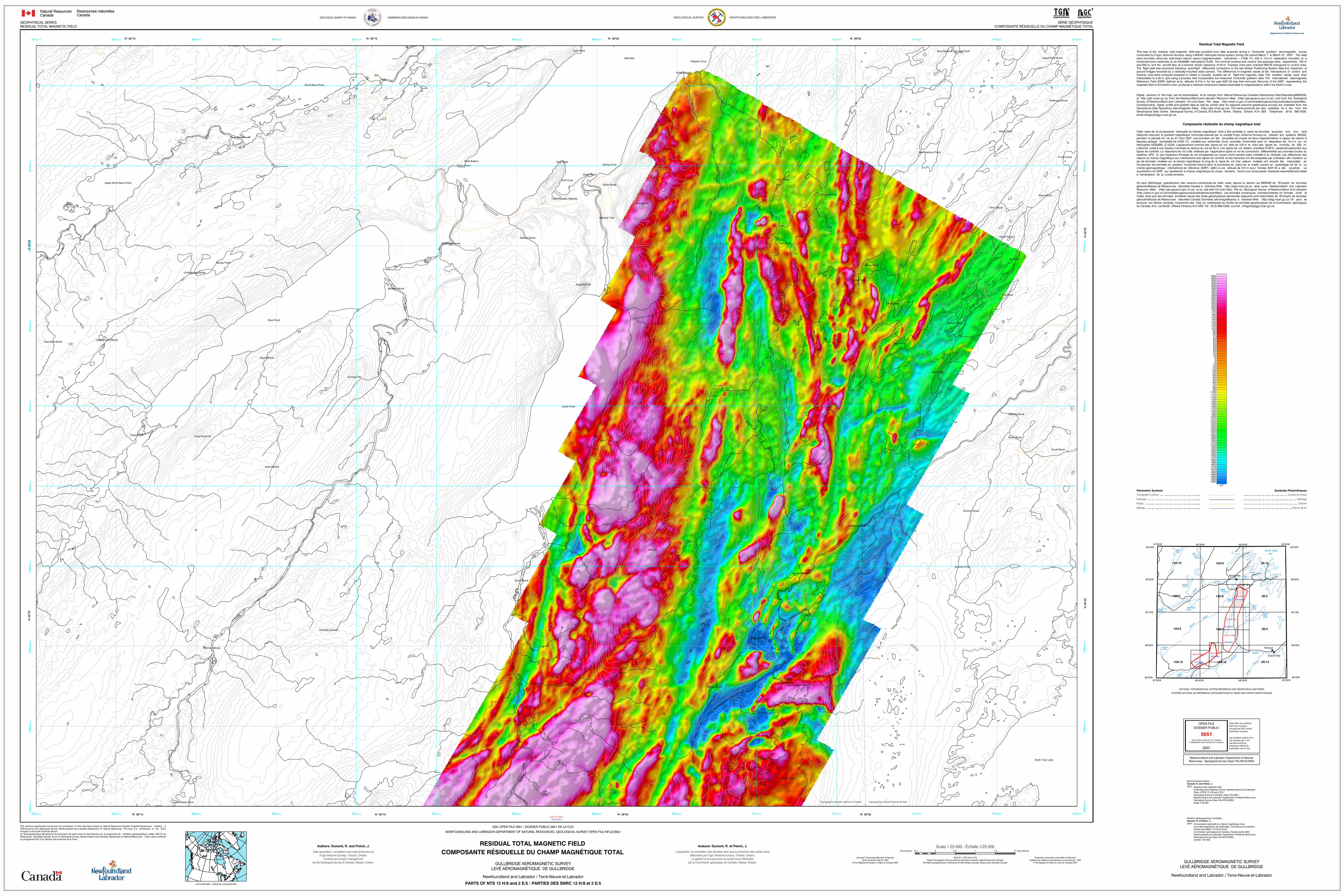
This surveymap of the residual total magnetic field was compiled from data acquired during a horizontal gradient aeromagnetic conducted databy Fugro Airborne Surveys using a MIDAS helicopter-borne system during the period March 1 to March 27, 2007. The were arecorded using two split-beam cesium vapour magnetometers (sensitivity = 0.005 nT) with a 13.4 m separation mounted on horizontal mboom assembly on an AS350BA helicopter(C-GJIX). The nominal traverse and control line spacings were, respectively, 100 and lines.500 m, and the aircraft flew at a nominal terrain clearance of 40 m. Traverse lines were oriented N60°W orthogonal to control The offlight path was recovered following post-flight differential corrections to the raw Global Positioning System data and inspection ground andimages recorded by a vertically-mounted video camera. The differences in magnetic values at the intersections of control traverse thenlines were computer-analysed to obtain a mutually levelled set of flight-line magnetic data. The levelled values were interpolated Geomagneticto a 20 m grid using a process that incorporated the measured horizontal gradient data. The International Reference theField (IGRF) defined at an altitude of 215 m for the year 2007.25 was then removed. Removal of the IGRF, representing magnetic field of the Earth's core, produces a residual component related essentially to magnetizations within the Earth's crust.

Residual Total Magnetic Field

Digital (MIRAGE)versions of this map, can be downloaded, at no charge, from Natural Resources Canada's Geoscience Data Repository at Geologicalhttp://gdr.nrcan.gc.ca, from the Newfoundland and Labrador Resource Atlas (http://gis.geosurv.gov.nl.ca/), and from the Survey http://www.nr.gov.nl.ca/mines&en/geosurvey/publications/openfiles/.of Newfoundland and Labrador On-Line Open File page Corresponding thedigital profile and gridded data as well as similar data for adjacent airborne geophysical surveys are available from Geoscience theData Repository (Aeromagnetic Data) (http://gdr.nrcan.gc.ca). The same products are also available, for a fee, from Geophysical 995-5326,Data Centre, Geological Survey of Canada, 615 Booth Street, Ottawa, Ontario, K1A 0E9. Telephone: (613) email:[email protected].

Cette levécarte de la composante résiduelle du champ magnétique total a été compilée à partir de données acquises lors d'un héliporté MIDAS,mesurant le gradient magnétique horizontal exécuté par la société Fugro Airborne Surveys en utilisant leur système pendant àla période du 1er au 27 mars 2007. Les données ont été recueillies au moyen de deux magnétomètres à vapeur de césium faisceau unpartagé (sensibilité de 0,005 nT) installés aux extrémités d'une poutrelle horizontale avec un séparation de 13.4 m sur hélicoptère m.AS350BA (C-GJIX). L'espacement nominal des lignes de vol était de 100 m et celui des lignes de contrôle, de 500 L'aéronef auxvolait à une hauteur nominale au dessus du sol de 40 m. Les lignes de vol étaient orientées N 60°O, perpendiculairement lignes dude contrôle. La trajectoire de vol a été restituée par l'application après le vol de corrections différentielles aux données brutes système desGPS et par inspection d'images du sol enregistrées au moyen d'une caméra vidéo installée à la verticale. Les différences valeurs undu champ magnétique aux intersections des lignes de contrôle et des traverses ont été analysées par ordinateur afin d'obtenir jeu ende données nivelées sur le champ magnétique le long de la ligne de vol. Ces valeurs nivelées ont ensuite été interpolées incorporant Leles données du gradient horizontal mesuré dans le processus du calcul de la maille suivant un quadrillage de 20 m. champ Lagéomagnétique international de référence (IGRF) défini à une altitude de 215 m pour l'année 2007.25 a été soustrait. soustraction reliéedu IGRF, qui représente le champ magnétique du noyau terrestre, fournit une composante résiduelle essentiellement à l'aimantation de la croûte terrestre.

Composante résiduelle du champ magnétique total

On donnéespeut télécharger gratuitement, des versions numériques de cette carte, depuis la section sur MIRAGE de l'Entrepôt de géoscientifiques Labradorde Ressources naturelles Canada à l'adresse Web http://edg.rncan.gc.ca ainsi qu'au Newfoundland and Resource LabradorAtlas (http://gis.geosurv.gov.nl.ca/) et au site-web On-Line Open File du Geological Survey of Newfoundland and (http://www.nr.gov.nl.ca/mines&en/geosurvey/publications/openfiles/). etLes données numériques correspondantes en formats profil maille donnéesainsi que des données similaires issues des levés géophysiques aéroportés adjacents sont disponibles de l'Entrepôt de géoscientifiques sede Ressources naturelles Canada (Données aéromagnétiques) à l'adresse Web http://edg.rncan.gc.ca On peut procurer géologiqueles mêmes produits, moyennant des frais, en s'adressant au Centre de données géophysiques de la Commission du Canada, 615, rue Booth, Ottawa (Ontario) K1A 0E9, Tél : (613) 995-5326, courriel : [email protected].

GULLBRIDGE AEROMAGNETIC SURVEYLEVÉ AÉROMAGNÉTIQUE DE GULLBRIDGE

Newfoundland and Labrador / Terre-Neuve-et-Labrador

GSC OF 5650012H/1813

Recommended citation:Dumont, R. and Potvin, J.2007:

Notation bibliographique conseillée :Dumont, R. et Potvin, J.2007 :

-550-500-480-460-440-420-410-400-390-380-370-360-350-340-330-320-310-300-290-280-270-260-250-240-230-220-210-200-190-180-170-160-150-140-130-120-110-100-90-80-70-60-50-40-30-25-20-15-10-505

1015202530405060708090

100110120130140150160170180200220240260280300320340360400450500600800

nT