i n t r o d u c t i o n - ibttm · i n t r o d u c t i o n 79 ii ... histoire des doctrines...
TRANSCRIPT

i n t r o d u c t i o n 79
IIR E C E P T I O N A N D A S S I M I L A T I O N
O F A R A B – I S L A M I C S C I E N C E I N T H E W E S T
[85] the first two—naturally quite modest—bibliographical studies devoted to books from the “Orient”, known in the West through transla-tions, appeared around the middle of the 19th cen-tury, at a time when Arab–Islamic science was looked upon with disdain rather than apprecia-tion, as the interests of historians were occupied increasingly by the development of natural sci-ences in the West. These two works are De auc-torum graecorum versionibus et commentariis syriacis arabicis armeniacis persicisque com-mentatio by Johann G. Wenrich (Leipzig 1842) and Die Übersetzungen der arabischen Werke in das Lateinische seit dem 11. Jahrhundert by Ferdinand Wüstenfeld (Göttingen 1877). For a long time, basically until today, interest in the question of the transfer of Arab–Islamic sci-ences—with the exception of certain subjects—was restricted to translators, works translated and extant manuscripts. Yet the issue of the impact of Arab–Islamic sciences as such in the West, be it through translations or through personal con-tacts, and the assessment of its significance rests mainly on the study of the scientific content of the Arabic (or Persian) writings and thus ulti-mately on the evaluation of the progress their authors made relative to their predecessors, in particular the Greeks. As shown above, Arabist research has meanwhile achieved remarkable results in the assessment of many surviving works so that a first evaluation in the context of the universal history of science was already fea-sible and even the question of the impact was addressed on a rudimentary level. The latter was largely limited to individual subjects or issues,
only in a few areas was the question of influence treated on a larger scale.
A rare phenomenon in the history of science is the French Arabist Ernest Renan (1823–1892), who dealt with the issue of the reception of the Arab–Islamic sciences in the West in the field of philosophy. Writing his ingenious and ad-mirable study Averroès et l’Averroïsme1 in 1853, Renan had at his disposal only a small number of sources and he could hardly count on the support of his contemporaries. Nevertheless his work has remained valid to some extent until today. Starting with the assumption that in 4th/10th century Spain, Arabic was the common lan-guage of Muslims, Christians and Jews, he real-ised the role of the latter in the dissemination of Arab–Islamic philosophy in [86] Europe.2 Renan maintained that secular Jewish literary culture in the Middle Ages was nothing but a mirror im-age of the Islamic culture,3 just as Jewish phi-losophy since Maimonides (Ibn Maim‚n) had, according to Renan, been nothing but a reflec-tion of Arabic philosophy.4 The entire school of Maimonides had remained true to the peripa-tetic tradition of Averroes (Ibn Rušd).5 In gen-eral, so Renan, Jewish philosophy bore the traits of Arabic philosophy, even after the Jews had
1 Third edition Paris 1867, reprint: Frankfurt, Institut für Geschichte der Arabisch–Islamischen Wissenschaften 1985.
2 E. Renan, Averroès et l’Averroïsme, op. cit., p. 174.3 ibid, p. 173.4 ibid, p. 175.5 ibid, p. 182.
s c i e n c e a n d t e c h n o l o g y i n i s l a m80
retreated to the Christian cities of Barcelona, Zaragoza, Narbonne, Montpellier, Lunel, Béziers, l’Argentière and Marseilles.6 In con-nection with the translation of Arabic works into Hebrew, Renan made the interesting observa-tion that Arabic words were retained or rendered by Hebrew words of the same root, even when these had a different meaning, hence the text was in a way emulated rather than translated.7
After his masterly description of the process of reception and assimilation of Arabic philosophy in western Europe through Jewish mediation as well as direct translation into Latin, including how this caused hatred amongst the Dominicans and the opposition of Raymundus Lullus, Renan traces the reception of Ibn Ru·d’s philosophy in Italy from the beginning of the 13th century. Here too Renan, well-read and witty, draws a lively picture of the scholarly circles who, af-ter three hundred years of studying the Arabic peripatetic teaching, had to endure the anti-Averroïsm reactions in the 16th century.
How deeply Arabic astronomy and astrol-ogy influenced the West was demonstrated best by the non-Arabist science-historian Pierre-Maurice-Marie Duhem8 (1861–1916) in vol-umes 2 to 4 of his monumental Le système du monde. Histoire des doctrines cosmologiques de Platon à Copernic.9 Although the great Arabist Carlo Alfonso Nallino in his Al-Batt®n¬ sive Albatenii opus astronomicum10 had already paved the way for future research with invalu-able hints, yet it is the results Duhem achieved through comparison of available Latin transla-tions of Arabic works of astronomical–astrolog-ical content with European works written under the influence of the former, which allow us to
6 E. Renan, Averroès et l’Averroïsme, op. cit., p. 184.7 ibid, p. 185.8 On him v. Donald G. Miller in: Dictionary of Scien-
tific Biography, vol. 4, New York 1971, pp. 225–233.9 Completed before 1916, published in 10 volumes,
Paris 1913–1959.10 Three volumes, Milan 1899–1907, reprint Hildesheim
1977.
comprehend how profound the impact of works translated from the Arabic was, not only on ar-eas of Duhem’s special interest, but far beyond, in the entire cultural history throughout Europe.
In the field of music and musical theory the question of the “Arabian influence” was ad-dressed, fortunately, quite early-on in compre-hensive studies. Not even a century had passed since the first surveys of “Arabian” music by R. G. Kiesewetter11 and J. G. L. Kosegarten,12 when the Spanish Arabist Julian Ribera y Tarragó in his La música de las Cantigas13 produced a pi-oneering work [87] on the question of Arabian influences. In the first of the three parts of his book he deals with the history of Arab music in the Islamic world up to the 6th/12th century and in the second part with its history in Spain. The third part is devoted to the author’s main interest, the question of the influence of Arab on Spanish music and on the European trouba-dours.14 It is understandable that Ribera’s ideas and results—particularly as regards the ques-tion of influences on Western polyphony in the Middle Ages—had their shortcomings, were in-apt in many points and could not be left without contradiction.
Three years after the publication of Ribera’s book, Henry George Farmer wrote his Clues for the Arabian Influence on European Musical
11 Die Musik der Araber, nach Originalquellen darg-estellt, with a foreword by J. v. Hammer-Purgstall, Leip-zig 1842, reprint Schaan (Liechtenstein) 1983.
12 Die moslemischen Schriftsteller über die Theorie der Musik, in: Zeitschrift für die Kunde des Morgenlandes (Bonn) 5/1844/137–163.
13 Published Madrid 1922, abridged English translation Music in ancient Arabia and Spain by Eleanor Hague and Marion Leffingwell, Stanford 1929, reprint New York 1970.
14 A useful summary of the contents is to be found in Otto Ursprung, Um die Frage nach dem arabischen bzw. maurischen Einfluß auf die abendländische Musik des Mittelalters, in: Zeitschrift für Musikwissenschaft (Leip-zig) 16/1934/129–141, 355–357, esp. 132–133.

i n t r o d u c t i o n 81
Theory15, which caused quite a stir.16 The work was promptly criticised by the music historian Kathleen Schlesinger in The Question of an Arabian Influence on Musical Theory.17 In 1929 Farmer’s comprehensive study of Arab musical history, A History of Arabian Music to the XIIIth Century, and in 1930 his Historical Facts for the Arabian Musical Influence appeared in London. In the latter he discusses at length, inter alia, K. Schlesinger’s criticism. Ignorant of those com-prehensive more recent treatments of the ques-tion by Farmer, Otto Ursprung published a sharp response to Farmer’s older works in 1934.18
Farmer’s main topics and hypotheses, refer-ring to Arabian influence and which encoun-tered harsh criticism, are matters of notation and early polyphony, solmisation, musical instru-ments, lute tablature and metric modes. The dis-cussion of many of these issues centred on the question of whether the new elements in music appearing from the 9th century in the West, go back to Græco-Byzantine or to Arab influences. Of course, Farmer did not deny the Greek basis of Arab musical theory, but he was convinced that the Arabs revised the inherited theories and developed them further. In 1976 two studies ap-peared on this subject in which Farmer’s conclu-sions are discussed and elaborated upon. These are Die Theorien zum arabischen Einfluß auf die europäische Musik des Mittelalters by Eva Ruth Perkuhn19 and Zur Rolle der Araber in der Musikgeschichte des europäischen Mittelalters
15 In: Journal of the Royal Asiatic Society 1925, pp. 61-80 (reprint in: The Science of Music in Islam, vol. 1, Frankfurt 1997, pp. 271-290).
16 Farmer’s approach was welcomed by Eugen Beichert in: Orientalistische Literaturzeitung (Leipzig) 29/1926/273–277.
17 In: The Musical Standard (London) n.s. 25/1925/148–150, 160–162.
18 Um die Frage nach dem arabischen bzw. maurischen Einfluß, op. cit.
19 Published in Walldorf (Hesse, Germany).
by Eckhard Neubauer.20 The author of the first study does not oppose the influence-theory in general, but she finds that “in the works on the problem of Arabian influence contributed by ethnomusicologists, methodological and theo-retical questions are dealt with in passing, if at all.”21 Ribera and Farmer, “the main proponents of the Arabian theory” were “known to be more Arabists than ethnomusicologists” and “hardly acquainted” either with the “practice of Arab music” or with the “problems of cultural anthro-pology and [88] ethnomusicology”.22 Their ap-proach met with harsh criticism23 “on the part of music historians who opposed the Arabian hy-pothesis on emotional rather than factual grounds” and “found a ready field for attacks in such eas-ily discernable theoretical flaws.” According to Ms. Perkuhn, both Ribera and Farmer gave “lit-tle consideration to the process of transmission.” Farmer however, “even went a step further nar-rowing himself down by excluding the ethnomu-sicological aspects, crucial for the research in ‘oral’ transmission and by limiting himself to musical instruments alone.”24 Hence she con-cludes that strictly speaking “the Arabian the-ory can only be established for the various as-pects of music making in the European Middle Ages after research in Arab music culture itself has been thoroughly revised and conventional or dictionary wisdom has been confronted with ethnomusicological and cultural–anthropologi-cal considerations.”25
The second26 of the two works mentioned above was penned by an Arabist and music his-torian and provides us not only with an adequate assessment of H. G. Farmer’s achievements but
20 In: Islam und Abendland. Geschichte und Gegen-wart, ed. by André Mercier, Bern and Frankfurt 1976, pp. 111–129.
21 E. R. Perkuhn, op. cit. p. 232.22 ibid, p. 232.23 ibid, p. 233.24 ibid, p. 233.25 ibid, p. 236.26 E. Neubauer, Zur Rolle der Araber, op. cit., p. 118 ff.

s c i e n c e a n d t e c h n o l o g y i n i s l a m82
beyond that also with results of more recent re-search: “In 1930 the musicologist Henry George Farmer summarised current theories on musi-cal influences of the Arabs, put them in focus and added many results of his own research. His Historical Facts for the Arabian Musical Influence have encountered fierce hostility but have so far not been refuted.” Issues discussed by Farmer taken up and elaborated upon here include “attempts to notate instrumental music, carried out both by the Arabs and in the European Middle Ages.27 They are based on the use of the letters of the alphabet for the designation of scale degrees, as known by the ancient Greeks, and the use of lines for pitch notation, which ap-pears to have originated in Middle Eastern late antiquity.28 The Arabs wrote down melodies in letter notation and with certain cue syllables or numerals for durations and rhythm; and they did this earlier and more frequently than the few ex-tant documents suggest. An alphabetic tabula-ture survives from the 10th century,29 and the Arabic Great Book of Songs [Kit®b al-A∫®n¬ al-kab¬r by Abu l-Fara™ al-I◊fah®n¬] preserves a report which is to be dated at the beginning of the 9th century about IsΩ®q al-Mau◊il¬… It says that IsΩ®q sent a new composition to one of his colleagues with written indications of all pitches, durations and phrasings. Thereupon the colleague sang the piece and he sang it correctly without ever hearing it.30 At the beginning of the 11th century Avicenna [Ibn S¬n®] demanded that a song must not be learnt without first writing it
27 H. G. Farmer, Historical Facts, p. 83 ff., 304 ff.; E. Neubauer, op. cit., pp. 119,127.
28 H. G. Farmer, Historical Facts, pp. 302 ff., 325 ff.; E. Neubauer, op. cit., pp. 119, 127.
29 Ris®lat YaΩy® b. al-Muna™™im fi l-m‚s¬q¬, ed. Zakar¬y®’ Y‚suf, Cairo 1964, p. 45; E. Neubauer, op. cit., pp. 119, 127.
30 Abu l-Fara™ al-I◊fah®n¬, Kit®b al-A∫®n¬ al-kab¬r, vol. 10, Cairo 1938, pp. 105–106; E. Neubauer, op. cit., pp. 119, 127.
down exactly, with pitches as well as lengths.31 Most of the extant types of Arab notation re-fer to the lute [‘‚d]. [89] According to Notker Labeo (d. 1022) and others, the alphabetical no-tation in the West also originated among instru-mentalists and was first used for the lira and the rota.32 Hence it appears that both sides origi-nally shared a common tradition. Yet when dur-ing Avicenna’s lifetime new concepts of pitch notation were introduced almost at the same time and according to the same principles by Hermannus Contractus (d. 1054) in Byzantium, this rather obviously implies an Arabic model,33 especially as Hermannus Contractus is known to have been acquainted with Arabic natural sciences.”34
“A further step in the development leads us to Guido of Arezzo’s (d. 1050) staff notation. He refers to his three to five parallel horizon-tal lines as ‘imitation of the string’35, and two of these lines are coloured: ‘lustrous saffron is gleaming where the third tone has its place; the sixth, however,… glows in vermilion’.36 While Guido’s sources for what until today has been considered his own achievement remain ob-scure,37 Arab practice of using coloured lute strings tuned to certain pitches offers at least a
31 Ab‚ ‘Al¬ Ibn S¬n®, a·-∞if®’. ar-Riy®¥¬y®t. 3. – ©aw®mi‘ ‘ilm al-m‚s¬q¬, ed. Zakar¬y®’ Y‚suf, 1956, p. 142; E. Neu-bauer, op. cit., pp. 119, 127.
32 H. G. Farmer, Historical Facts, op. cit. p. 317; E. Neubauer, op. cit., pp. 119, 127.
33 H. G. Farmer, Historical Facts, op. cit. pp. 36, 83 ff.; E. Jammers, Gedanken und Beobachtungen zur Ge-schichte der Notenschriften, in: Festschrift Walter Wiora, Kassel 1967, p. 199; E. Neubauer, op. cit., pp. 119,127.
34 H. G. Farmer, Historical Facts, op. cit., p. 35; E. Neu-bauer, op. cit. pp. 119,127.
35 H. Oesch, Guido von Arezzo, Bern 1954, p. 5; E. Neu-bauer, op. cit., pp. 119, 127.
36 H. Oesch, op. cit.p. 6; E. Neubauer, op. cit., pp. 119, 127.
37 O. Ursprung, Um die Frage nach dem arabischen bzw. maurischen Einfluß, op. cit., pp. 137–138, 356; E. Neu-bauer, op. cit., pp. 119–120, 127.

i n t r o d u c t i o n 83
convincing explanation for the association of colour and string/line.”
After commenting upon further points which had irritated Farmer’s adversaries, Neubauer continues:38 “We are on safe grounds again re-garding the impact caused by the translation of Arabic texts. In the field of musical theory it is the impulses which the philosopher Ab‚ Na◊r al-F®r®b¬ (d. 950) gave through the Latin trans-lation of his Enumeration of Sciences [IΩ◊® ’ al-‘ul‚m; De scientiis]39. In addition to the familiar division in musica mundana, humana and in-strumentalis, in the middle of the 12th century the West became acquainted, through this trea-tise, with another distinction of musica specula-tiva and activa—a classification which is derived from the practice of the performing musician ‘which can either be contemplative and explor-ing (speculative) or active’.40 It was already known in Greek music theory and was now in-troduced in elaborated form to the mediæval lit-erature where it brought about a significant ‘en-richment of the subject matter’ of theoretical reflections.”41
“The translation of Arabic works on natural sci-ences and philosophy reached its peak in Spain during the 12th and 13th centuries. It is signifi-cant that their dissemination coincided with the foundation of the first European universities and largely dominated their curricula.42 The writings of Avicenna were amongst the most prominent
38 Zur Rolle der Araber in der Musikgeschichte des eu-ropäischen Mittelalters, op. cit., pp. 122–123.
39 H. G. Farmer, al-F®r®b¬’s Arabic–Latin writings on music, London 1934 (reprint: New York 1965 and: The Science of Music in Islam, vol. 1, Frankfurt 1997, pp. 463–533); E. A. Beichert, Die Wissenschaft der Musik bei al-F®r®b¬, Regensburg 1931, pp 24 ff.; E. Neubauer, Zur Rolle der Araber, pp.123, 128.
40 v. G. Pietzsch, Die Klassifikation der Musik von Boe-tius bis Vgolino von Orvieto, Halle 1929 (reprint: Darm-stadt 1968), p. 79; E. Neubauer, op. cit., pp. 123, 128.
41 G. Pietzsch, op. cit. p. 78; E. Neubauer, op. cit., pp. 123, 128.
42 H. Schipperges, Einflüsse arabischer Wissenschaften auf die Entstehung der Universität, in: Nova Acta Leopol-
in this development, [90] including some parts of his Kit®b a·-∞if®’ under the Latin title Liber sufficientiæ.”“On the same route, via translations and univer-
sity curricula—first in Spain, Italy and France—the West was also introduced to the highly devel-oped theory and practice of Arab music therapy. The use of sounds and melodies for restraining emotions occupied an important position in the dietetics of Arab medicine. They had developed their lore from ancient Greek theory and Late Antiquity’s practical experience; they knew that the Persians of the Sassanid period tried to cure melancholy with music and the post-Platonic ethos had far reaching influence… down to the association of lute strings with the fluids of the body.”43
In the second half of the 20th century, Heinrich Schipperges earned merits with his numerous treatises and monographs on the reception and assimilation of Arabic-Islamic medicine. In full appreciation of the importance of his various ar-ticles, we shall focus here primarily on his two works dealing with our subject on a broader scale. In one of them, entitled Ideologie und Historiographie des Arabismus,44 Schipperges was, as far as I am aware, the first to tackle the difficult task of assessing the reception and as-similation of Arab–Islamic sciences from the viewpoint of historiography. He begins with the time at which an awareness for the phenomenon had first arisen and traces its development up to the middle of the 20th century. In his compre-hensive study Schipperges draws a clear picture of the antagonistic attitude prevalent from the 13th century towards knowledge adopted from the Arab–Islamic world. This in turn caused the current almost total lack of appreciation of this heritage, despite all attempts to do justice to its great importance. For Schipperges him-
dina (Halle) 27/1963/201–212; E. Neubauer, op. cit. pp., 123, 128.
43 E. Neubauer, op. cit. p. 123.44 Wiesbaden 1961; supra, p. 2.

s c i e n c e a n d t e c h n o l o g y i n i s l a m84
self Arabism is a “phenomenon that has exerted powerful influence over the centuries and still continues to do so and without which we will not understand the configuration of the modern world.”45
The second of the two works, entitled Die Assimilation der arabischen Medizin durch das lateinische Mittelalter46 was extremely helpful in our attempt to obtain the most realistic pos-sible picture of the science-historic phenome-non of reception of Arab–Islamic science in the West and its impact. In this work Schipperges concentrates mainly on the question: “How did the reception of Arabic medicine in the Latin Middle Ages take place?”47 Schipperges fre-quently uses the term “Graeco-Arabic” for the adopted medicine, meaning the one in the Arab–Islamic area based on the achievements of the Greek predecessors. After defining the subject he initially focusses on the period between the late 11th century and the end of the 13th century, a time when, according to his view, “Arabism” played an important role: “The reception of Graeco-Arabic medicine is considered only from the perspective of the Latin tradition; in-vestigation stops with the translators and their work, it does not pursue the Arabic subject mat-ter, but rather limits itself to the Latin manu-scripts.”48 Schipperges believed it was his task
“to question systematically the [91] current no-tions about the period of reception and thus ul-timately the received image of mediaeval med-icine in general.”49 With this goal in mind, he from the onset bypasses the discussion of med-ical matters and theory. Rather he pursues his aim on the basis of an historiographical survey
“on “the judgement of the centuries on the ques-
45 H. Schipperges, Ideologie und Historiographie des Arabismus, op. cit. p. 5.
46 Wiesbaden 1964.47 H. Schipperges, Die Assimilation der arabischen
Medizin, op. cit. p. 2.48 ibid, p. 2.49 H. Schipperges, Die Assimilation... op. cit. p. 9.
tion of the importance of Arabic–Latin transla-tions for Western medicine”.50
Schipperges assumes the process of recep-tion began in 11th century Salerno in connec-tion with the converted Arab and later monk of Monte Cassino, Constantinus Africanus (ca. 1015–1087), whom Karl Sudhoff51 in 1930 had called “quite a providential character for the Western medicine of the Middle Ages.” Apparently, Constantine hailed from Carthage and found his way to Salerno, after a thor-ough and multifarious study of sciences in Iraq and other countries—as reported by a Western source about 50 years after his death.52 He car-ried dozens of Arabic medical books with him or had them sent later. With astounding dili-gence and probably also supported by members of his order, he succeeded in bringing into cir-culation more than 25 of those books in Latin. For the most part he claimed them as his own writings, a few he ascribed to Greek authorities. Most significant amongst these books was un-doubtedly the extensive textbook of medicine by ‘Al¬ b. al-‘Abb®s al-Ma™‚s¬ (d. last quarter of the 4th/10th century) dedicated to the B‚yid prince ‘A¥udaddaula (r. 388/949–372/983) and enti-tled K®mil a◊-◊in®‘a afl-flibb¬ya or al-Kunn®· al-malak¬.53 This work, the Latin version of which bore a title, Liber pantegni, made up to sound
50 ibid, p. 9.51 Konstantin der Afrikaner und die Medizinschule von
Salerno, in: Sudhoffs Archiv für Geschichte der Medizin (Leipzig) 23/1930/293–298, esp. p. 293 (reprint in: Is-lamic Medicine, vol. 43, pp. 179–184, esp. p. 179).
52 v. Rudolf Creutz, Der Arzt Constantinus Africanus von Montekassino. Sein Leben, sein Werk und seine Be-deutung für die mittelalterliche medizinische Wissen-schaft, in: Studien und Mitteilunger zur Geschichte des Benediktiner-Ordens und seiner Zweige (Munich) 47 (N. F. 16), 1929, pp. 1–44, esp. pp. 2–3 (reprint in: Islamic Medicine, vol. 43, pp. 197–240, esp. pp. 198–199).
53 v. F. Sezgin, op. cit. vol. 3, pp. 320–322; facsimile edi-tion of the book in 3 volumes Frankfurt, Institut für Ges-chichte der Arabisch–Islamischen Wissenschaften 1985.

i n t r o d u c t i o n 85
Greek, was described by K. Sudhoff54 as a work conceived like “cast from a mould… with such integral order and logical consistency, the like of which was not known in Greek medicine at all.”
In 1127, exactly 40 years after Constantinus`s’ death, Stephanus of Antioch translated the book into Latin a second time, but now under the name of its true author, ‘Al¬ b. al-‘Abb®s (Liber com-pletus artis medicinæ, qui dicitur regalis dis-positio hali filii abbas…).55 This clearly contra-dicted the statement by Constantinus, who had introduced himself as the author of the book:
“He, Constantine, inspired by the great benefit of this science, had at first examined various Latin works and found them inapt for teaching. Thereupon [92] he had taken recourse to the old Greek authors Hippocrates and Galenos, and of the more recent ones to Oribasius (of Byzantium), Alexander (of Tralles) and Paulus (of Ægina). He did not want to imitate Hippocrates, the excel-lent sovereign of the art, alone, as he found him often obscure and brief. Galen had written many extensive works… yet by their sheer magnitude discouraged many and consequently sixteen of his works were commonly used at most.”56 After Stephanus of Antioch, the second translator of the book, had accused Constantinus of plagia-rism the latter’s standing as an author was and
54 Konstantin der Afrikaner, op. cit. p. 295 (reprint: op. cit. p. 181).
55 v. R. Creutz, Der Arzt Constantinus Africanus von Montekassino, op. cit. p. 24 (reprint op. cit. p. 220). This Stephanus came from Pisa, went to Syria later, spent some time in Antioch and brought medical books back to Pisa, amongst them apparently a complete copy of the book by ‘Al¬ b. al-‘Abb®s, cf. Charles Burnett, Antioch as a link between Arabic and Latin culture in the twelfth and thirteenth centuries, in: Occident et Proche-Orient: Con-tacts scientifiques au temps des Croisades. Actes du col-loque de Louvain-la-Neuve, 24 et 25 mars 1997, ed. by I. Draelants, A. Tihon and B. van den Abeele [Turnhout:] Brepols 2000, pp. 1–19, esp. pp. 4–10 (infra p. 151 ff.).
56 R. Creutz, Der Arzt Constantinus Africanus von Montekassino, op. cit. pp. 17–18 (reprint, op. cit. pp. 213–214).
still is judged on widely differing terms. He was despised as a“plagiarist”, praised as a“magister orientis et occidentis novusque effulgens Hippocrates” and disparaged as a “mad monk”. Finally, around the middle of the 19th century, a French historian of medicine finally demanded
“that a congress of European scholars may erect a statue of Constantine at the gulf of Salerno or on the height of Monte-Cassino.” In Julius Hirschberg’s opinion, Constantine “the Arabic renegade and later monk of Monte Cassino was not yet languishing under the concept of intel-lectual property.”57 On the other hand, he was praised by Karl Sudhoff:58 “Constantine loos-ened Salerno’s tongue. Under his influence, stim-ulated by his gifts, it now created its own litera-ture, the first in the Western Middle Ages in the field of medicine. And even if one has to cancel out many excessively laudatory phrases about him by another member of his order, Petrus Diaconus, yet one fact is undisputed: he became the preceptor of the medical West, the ‘Magister Occidentis’!” Sudhoff59 knew that Constantine brought into circulation various other Arabic medical books under his own name and he jus-tifies this process thus: “no author’s name is given in the case of purely Eastern writers to whom a number of minor works, such as a book on coitus, one on melancholy, one on forgetful-ness and one on elephantiasis might belong as
57 R. Creutz, Der Arzt Constantinus Africanus von Montekassino, op. cit. p. 1 (reprint, op. cit. p. 197); J. Hirschberg, Über das älteste arabische Lehrbuch der Augenheilkunde, in: Sitzungsberichte der Königlich Preußischen Akademie der Wissenschaften (Berlin), Jahr-gang 1903, pp. 1080–1094, esp. p. 1088 (reprint in: Is-lamic Medicine, vol. 23, pp. 30–44, esp. p. 38).
58 Constantin der Afrikaner und die Medizinschule von Salerno, op. cit. pp. 297–298 (reprint, op. cit. pp. 183–184).
59 Constantin, der erste Vermittler muslimischer Wissen-schaft ins Abendland und die beiden Salernitaner Früh-scholastiker Maurus und Urso, als Exponenten dieser Vermittlung, in: Archeion (Rome and Paris) 14/1932/359–369, esp. p. 362 (reprint in: Islamic Medicine, vol. 43, pp. 185–195, esp. p. 188).

s c i e n c e a n d t e c h n o l o g y i n i s l a m86
well, where only his [Constantine’s] own name is mentioned as in the case of ‘Viaticus’ and ‘Pantegni’, which unjustly carry his name even though they are merely translations from the Arabic. Presumably he was hoping they would be accepted more readily by the scholarly cir-cles of Salerno without the name of a Muslim author.”
Against this reasoning by Sudhoff the objec-tion can be raised that Constantine also pre-sented the Latin version of the ophthalmology book (Kit®b ‘A·r maq®l®t) by ºunain b. IsΩ®q60 (194/809–260/873) as his own work to his read-ers. The latter was however not a Muslim but Christian and Constantine could thus have men-tioned his name and religion with pride. Yet his preface to this book reads in translation: “Those words that we have explained sufficiently in the books ‘Pantegni’ and ‘Viaticus’ about the eyes are all that was available in the Latin language, because at the time we did not yet know the present small volume [93] dealing with the eyes. And therefore I, Constantine, monk of Monte Cassino, have compiled this booklet for you, Johannes, in order that you may find [more]—if you find the teachings of those books insuf-ficient—whatever you may want to learn about the causes of ophthalmology, i.e. about the na-ture of the eyes and their composition.”61
It is surprising that Constantine on the one hand mentions the ‘small volume’ he used, thus giving himself away, yet on the other hand pro-fesses unambiguously to be its author. At any rate, this book on ophthalmology was consid-ered his own achievement for more than 800 years until in 1903 J. Hirschberg was able to prove that it is in fact a translation of ºunain b. IsΩ®q’s book. This is all the more surpris-ing because—as Hirschberg also has pointed out—ºunain’s work circulated in the West for
60 v. F. Sezgin, op. cit. vol. 3, pp. 247–256.61 Translated from Der ‘Liber de oculis’ des Constanti-
nus Africanus. Übersetzung und Kommentar by Domin-ique Haefeli-Till, Zurich 1977, p. 22.
centuries in another Latin translation, this time as a work by Galen and with the name of one Demetrio as translator. Constantine’s book “cor-responds, however, most exactly with the so-called Galeni de oculis liber a Demetrio trans-latus. It contains neither one sentence more nor less, it has the same sequence of topics—it merely has a different division of the chapters and it concludes earlier than the latter, because the last section (the tenth maq®la) on eye oint-ments is missing.”62
In order to shed light on the question of how Constantine dealt with his Arabic sources his De melancholia shall be mentioned as another ex-ample. That book, printed in 1536 as a work by Rufus (of Ephesos), in the manuscript tradition is attributed to Constantine, following his state-ment in the book’s incipit: “I, Constantine, com-piled this little book from many works of our most experienced doctors in that field, gathering excerpts of all that seemed excellent to me. We see that the celebrated physician Rufus has writ-ten a book on melancholy and in its first part said much about the symptoms of people with a mel-ancholy disposition. This book is about the hy-pochondriac type of melancholy, but Rufus also touched upon and knew the other two types.”63
This incipit can serve as an instructive ex-ample of Constantine’s treatment of his Arabic sources. He replaced the name of the true author with his own, as shown by comparison with the incipit of the original.64 Even if we gather more
62 J. Hirschberg, Über das älteste arabische Lehrbuch der Augenheilkunde, op. cit. p. 1088 (reprint, op. cit. p. 38); cf. F. Sezgin, op. cit. vol. 3, p. 252.
63 R. Creutz and W. Creutz, Die “Melancholia” bei Konstantinus Africanus und seinen Quellen. Eine histor-isch–psychiatrische Studie, in: Archiv für Psychiatrie und Nervenkrankheiten (Berlin) 97/1932/244–269, esp. p. 261 (reprint in: Islamic Medicine, vol. 43, pp. 312–337, esp. p. 329).
64 “This little book on the disease known as melancholy, viz. the sullen depression, was written by the physician IsΩ®q b. ‘Imr®n as a memory aid for himself (in case of an eventual loss of memory, particularly approaching old age, which Plato used to call the mother of forgetful-

i n t r o d u c t i o n 87
examples from Constantine’s works, the picture we get remains the same. They are very free translations with arbitrary [94] omissions, doing away with the names of Arab doctors, particu-larly those of the real authors. Latin texts of this kind, written in 11th century Salerno were, in Schipperges’ terms, the result of a “first wave of reception”65 in the field of medicine. In his view
“the elements of rational structure reveal a sys-tematic organisation of the corpus.”66 In this re-spect I come to a different conclusion. The orig-inal writings of the corpus consisted of works commonly known in western North Africa. Constantine’s selection was not by design but arbitrary. He took what he could collect with-out great effort, brought the Arabic writings to Salerno and made them, as far as possible, ac-cessible in Latin with the help of the members of his order. No purposeful systematic work can be expected of him.
As far as Constantine’s influence is concerned, Schipperges argues that he had “no strategic impact” on Western medicine. “It only had a preliminary influence on European schools in general, however important the Corpus Constantinum was to become for Salerno.”67 With this assessment Schipperges is right in so far as he compares this first wave of reception
ness) as also to the benefit of those interested amongst the friends of medicine and followers of philosophy. IsΩ®q b. ‘Imr®n said: I have not found a satisfactory treatise on mel-ancholy or a definite word about this disease in the writ-ings of any of my precursors, the exception being a man from the lineage of predecessors called Rufus of Ephe-sus.” Quoted, with slight changes, from the translation by Karl Garber, IsΩ®q ibn ‘Imr®n, Maq®la f¬ l-m®l¬¿‚liy® (Abhandlung über die Melancholie) und Constantini Af-ricani Libri duo de melancholia, Hamburg [1977], p. 1; cf. the German translation by A. Bumm, Die Identität der Abhandlungen des IsΩ®∆ Ibn ‘Amr®n und des Constanti-nus Africanus über die Melancholie, München 1903, pp. 9–10.
65 Die Assimilation der arabischen Medizin, op. cit. p. 50.
66 ibid, p. 53.67 ibid, pp. 53–54.
of medical works with the second wave com-ing via the Iberian peninsula. Yet the bearing of this ‘preliminary’ influence should not be un-derestimated. Especially as, with one single ex-ception, these translations of more than twenty works were never replaced by better ones but re-mained in circulation as works by Constantine for centuries .
As far as Constantine’s treatment of his mod-els is concerned, Schipperges avoids calling him a plagiarist. He holds that for Constantine’s achievement the common term of reception was unsuitable. It was, right from the beginning, rather a revision of foreign learning to a cer-tain coherent end, viz. an intentional fusion (of the interpretation of doctrines for a wider pub-lic) and adaptation. For this, so Schipperges, the term assimilation should be used.68 I, however, do not believe that the terms Schipperges sug-gests are apt to the way Constantine treats his originals. In my opinion, the latter’s translations are nothing but a form of reception. Certainly Constantine’s omission of the real authors of the works he translated was under no circumstances justified. It should be asked why he acted like this. In 1930 Hermann Lehmann69 remarked in this context: “I do not see any other explana-tion but that he intended to exalt his standing in the university of Salerno.” I would tend towards a more differentiated explanation according to which Constantine’s plagiaristic treatment of his originals goes back to more than one factor:1. The 13th century report on Constantine’s decision to bring Arabic medical books to Salerno appears significant to me. It relates how Constantine asked a physician in Salerno whether they were “sufficiently equipped with medical literature in the Latin language, which could not be affirmed. One had acquired knowl-
68 ibid, p. 52.69 Die Arbeitsweise des Constantinus Africanus und des
Johannes Afflacius im Verhältnis zueinander, in: Archeion (Rome) 12/1930/272–281, esp. p. 280 (reprint in: Islamic Medicine, vol. 43, pp. 338–347, esp. p. 346).

s c i e n c e a n d t e c h n o l o g y i n i s l a m88
edge through practical application of ‘studio et exercitio’ and used them.”“From that Constantine had understood his cul-
tural mission, returned to Carthage… and again applied himself to medicine for three [95] years, also collecting plenty of Arabic medical text-books,… had then embarked… was overtaken by a storm… which badly damaged his manu-script treasures… With the remainder of it he luckily reached Salerno in the end.”70 The crucial point in this report appears to be that the medical pursuits of the monks in the monas-tery of Monte Cassino, above Salerno, who were joined by Constantine, are said to have been of a practical nature only and that the monks had lit-tle or no literary experience at least in the field of medicine. Consequently they could not be ex-pected to be concerned by the uncertainty cre-ated by Constantine in the question of author-ship of the books translated from the Arabic.2. Constantine was far superior to the other mem-bers of his order in his knowledge of languages, comprehension of the subject and also in liter-ary ability. The monks presumably treated him like a prince and he decided freely and without interference on questions of authorship.
3. That he conceals the names of Arab authors of the translated works and of Arabic sources cited therein in favour of the Greek elements seems to have had religious motives.71
Schipperges sees the beginning of the sec-ond phase of reception of Arabic medicine in the first half of the 12th century in Toledo which had been under Arab rule from 711 to 1085. Not without influences through sporadic translations of Arabic books72 into Latin which
70 Karl Sudhoff, Constantin, der erste Vermittler mus-limischer Wissenschaft ins Abendland… op. cit. pp. 360–361 (reprint: op. cit. pp. 186–187).
71 A number of recent studies on Constantinus Africa-nus were edited by Charles Burnett and Danielle Jacquart, Constantine the African and ‘Al¬ ibn al-‘Abb®s al-Ma™‚s¬. The Pantegni and related texts, Leiden etc. 1994.
72 H. Schipperges, Die Assimilation der arabischen Medizin, op. cit. p. 87.
had already begun in the 10th century on the Iberian peninsula, an intensive “reception of the Arabic Aristotle”73 started in Toledo. The city not only offered a wealth of written docu-ments of Arab–Islamic learning to the Christian conquerors but also “the suitable climate for extensive cultural exchange because of its lin-guistic and cultural disposition.”74 Schipperges calls the peripatetic encyclopaedia that reached the West with this wave of reception the ‘new Aristotle’.75 It was the Kit®b a·-∞if®’ of Ab‚ ‘Al¬ Ibn S¬n® (Avicenna, 980–1037), a revision of the Aristotelian Corpus.76
Schipperges considers an advanced stage of the translation process in Toledo as a third wave of reception of Arabic medicine in the West. It took place in the second half of the 12th cen-tury; its most eminent translator was Gerard of Cremona (ca. 1114–1187). Amongst the works of Ab‚ Bakr ar-R®z¬77 (Rhazes, 865–925) he translated the books al-Kit®b al-Man◊‚r¬ fi fl-flibb (Liber medicinalis ad Almansorem), Kit®b at-Taqs¬m (Liber divisionis) and Kit®b al-©adar¬ wa-l-Ωa◊ba (De variolis et morbillis). “With this body of writings, a solid foundation was laid for pathology and therapy. The awe inspiring last work of Rhazes, al-º®w¬ or Continens was not translated until a century later by Fara™ ben S®lim”78 and remained incomplete.
[96] Of greatest importance for the process of reception of Arab medicine in Toledo was the translation, also by Gerard of Cremona, of the Kit®b al-Q®n‚n fi fl-flibb (Liber canonis de me-dicina) by Ab‚ ‘Al¬ Ibn S¬n®, which became the ultimate “codex of basic rules for a scientific medicine, including in the West”.79
73 ibid, pp 55 ff.74 ibid, p. 56.75 ibid, p. 56.76 ibid, p. 58.77 v. F. Sezgin, op. cit. vol. 3, pp. 274–294.78 H. Schipperges, Die Assimilation der arabischen
Medizin, op. cit. p. 93.79 H. Schipperges, Die Assimilation der arabischen
Medizin, op. cit. p. 93.

i n t r o d u c t i o n 89
Mention should also be made here of the 30th chapter (on surgery) of the at-Ta◊r¬f li-man
‘a™iza ‘an at-ta◊n¬f, a comprehensive textbook of medicine by Abu l-Q®sim øalaf b. ‘Abb®s az-Zahr®w¬80 (d. ca. 400/1010), also translated by Gerard of Cremona. This text, known in the West under the title Chirurgia Albucasis or Tractatus de operatione manus 81, has influenced surgery for centuries.
It should further be mentioned here that in the course of the Toledean vogue of medical transla-tion, the “Introduction to Medicine” (al-Mud¿al ila fl-flibb or Mas®’il fi fl-flibb li-l-muta‘allim¬n) by ºunain b. IsΩ®q82 (809–973), which had al-ready reached the West under the title Ysagoge Iohannicii ad tegni Galieni 83 in translation by Constantinus Africanus, was brought into circu-lation again, as Liber introductorius in medici-nam, by one Marcus of Toledo. This work was amongst the medical manuals with the widest dissemination in Europe and was “read at all universities until well into the 17th century”.84
In the second part of his book, devoted to “peo-ple and centres of assimilation,” Schipperges at-tempts, at least regarding the 13th century, to shed light on the question as to what became of the Arabic books translated during the three waves of reception. “What role did those adopted and assimilated texts play in European medicine? In which ways and through what channels was the new learning incorporated into mediaeval thera-peutics? Who were the exponents of these trans-fers, conflicts, codifications? What happened to these elements which, as Arabism in the wider sense, run through the late Middle Ages?”85
80 v. F. Sezgin, op. cit. vol. 3, pp. 323–325.81 v. H. Schipperges, op. cit. p. 95.82 v. F. Sezgin, op. cit. vol. 3, pp. 247-256.83 v. H. Schipperges, Die Assimilation der arabischen
Medizin, op. cit. pp. 33, 89.84 H. Schipperges, Eine griechisch–arabische Ein-
führung in die Medizin, in: Deutsche medizinische Wo-chenschrift (Stuttgart) 87/1962/1675–1680, esp. p. 1675.
85 H. Schipperges, Die Assimilation der arabischen Medizin, op. cit. p. 107.
In order to answer these questions, Schipperges focuses on the “centres of assimilation” in France, England and Southern Italy. In Chartres, which had come in contact with Arabic natural sciences from about the turn of the 10th century, the 12th century brought about the acquaint-ance with Aristotle (Arabus) and with Arab as-tronomy and medicine.86 After the re-conquest of the Spanish provinces, French schools started
“the reception of Arabic learning from cultural centres under Arab influence. Early in the 12th century we encounter the first documents of a new scientific flourishing as a result of the con-tact with Arabic sciences in Southern France.”87
“Towards the middle of the 12th century a cen-tre of translation emerged in Toulouse. It was based on the French tradition and soon formed a bridge to the centres of learning in Spain.”88 The most important translators of the Toulouse school in the 12th century were Hermanus Dalmata and Robert of Chester. The books translated by them predominantly belong to the fields of astronomy, astrology and physics.
[97] “The school of Toulouse gained further prominence at the beginning of the 13th century after the Parisian edict prohibiting Aristotle had been passed in 1215, when it became a warrant of a continuing Aristotelian tradition; philosophy and natural sciences enjoyed special attention in this school. Even though Pope Innocence IV ex-tended the edict to the university of Toulouse in 1245 and Urban IV renewed it in 1263, these or-dinances no longer had any practical effect”.89
In the French centres of mediation, Jewish scholars played an important role by translating Arabic works into Hebrew and Latin. In connec-tion with these scholars, Schipperges points out two facts which are significant for both the his-tory of culture and the history of science. Firstly, the workshops of the translators were closely
86 ibid, pp. 111–118.87 ibid, pp. 123–124.88 ibid, p. 124. 89 ibid, pp. 126–127.

s c i e n c e a n d t e c h n o l o g y i n i s l a m90
connected with the synagogues just like the ma-drasa to the mosque in Islamic culture, “a fea-ture obviously in common with the Western in-stitution of cathedral and monastery schools, and thus becoming a factor in the process of as-similation which must not be underestimated.”90 Secondly, the tolerance practised towards the schools in the French region and the Jewish translators active there is surprising, particu-larly considering that in 1241 Christians could be excommunicated if they saw Jewish doctors for treatment.91
In Paris, where in 1215 the study of Aristotle had been interdicted, the “new Aristotle” (Aristoteles Arabus) emerged victoriously from the middle of the 13th century in close associa-tion with the Latinised Ibn S¬n® (Avicenna).92 In this connection it is worth noting that “around the middle of the 13th century… the rationalistic enlightenment of Averroëan philosophy was al-ready being officially fought and condemned.”93
“Averroës, the epitome of all heresy in the Middle Ages, was not taken as a historical fig-ure but as a weapon in the conflicting opinions of the 13th century. He was attributed with say-ing what nobody dared to express in any literary form, yet he also declared war indiscriminately against all extreme systems. Only the theologi-cal exponents of the 14th century tried to rectify pure Averroïsm. Through him, Paris became the place of encounter with Arabised antiquity in its most extreme form.”94 “For the Parisian school Averroës was, in the
13th century, more of a personification of spec-ulative endeavours in medicine and natural sci-ences, whilst in practical medicine Avicenna maintained his central position there as well.”95
After his overview of the French schools, Schipperges moves on to the encounter of the
90 H. Schipperges, Die Assimilation… op. cit. p. 128.91 ibid, p. 128.92 ibid, p. 129 ff.93 ibid, p. 136.94 ibid, pp. 137–138.95 ibid, p. 138.
English with Arabism:96 “Only one genera-tion after Constantinus Africanus, a movement of scientific migration to the Arabised centres in southern Italy and Spain began in the Anglo-Saxon region which was to lead to a new and spontaneous wave of assimilation. Initially the subject was not medical science but the new mathematics and astronomy which, however, were to become very important for the founda-tion of the new perception of nature and thus also for the scientific foundations of medicine.”“In the Spanish–Frankish region or in south-
ern Italy, the Anglo-Saxon pioneers had a par-ticularly vivid encounter [98] with the new science resulting in a broad and creative assim-ilation of the new material. After returning to their old schools in England they realised how dusty those were. In the attempt to break open the crusts, the new sciences became the timber from which the 13th century centres of learning in England were fashioned.”97
The most important representative of this movement was Adelard of Bath98 (active 1116–1142). After long sojourns in centres of assimila-tion in France, Spain, Italy and Syria, he returned to England. Through translations from Arabic into Latin he made some important astronomi-cal–astrological and mathematical books acces-sible in Europe.99 He was possibly not only the
96 ibid, pp. 142 ff97 ibid, p. 143.98 About him v. Marshall Clagett in: Dictionary of Sci-
entific Biography, vol. 1, New York 1970, pp. 61–64.99 v. Adelard of Bath. An English scientist and Arabist
of the early twelfth century, ed. Charles Burnett, Lon-don 1987, including the following contributions: Marga-ret Gibson, Adelard of Bath; Alison Drew, The De eodem et diverso; Dafydd Evans, Adelard on Falconry; Charles Burnett and Louise Cochrane, Adelard and the Mappae clavicula; Gillain Evans, A note on the Regule abaci; André Allard, L’époque d’Adelard et les chiffres arabes dans les manuscrits latins d’arithmétique; Richard Lorch, Some remarks on the Arabic–Latin Euclid; Menso Folk-erts, Adelard’s version of Euclid’s Elements; Charles Burnett, Adelard, music and the quadrivium; Raymond Mercier, Astronomical tables in the twelfth century; Em-

i n t r o d u c t i o n 91
first Englishman but the first European to draw attention to the higher standard of Arab–Islamic sciences as compared to his own culture area (infra p. 138).100 Amongst the other mediators who promoted the new knowledge of the natural sciences were Robertus de Losinga101 who was the bishop of Hereford from 1079 to 1095 and, above all, Walcher of Malvern (d. 1135). This scholar, who was born in the Lorraine, visited Italy and came to England in 1091. He continued the process of assimilation in Adelard of Bath’s spirit.102 Moreover, in the second half of the 12th century Roger of Hereford founded a centre for Arabist studies in Malvern (Herefordshire).103
While dealing with the topic of Arabism and England we must not forget Robert of Chester. Although he was not an Englishman, he was, ac-cording to Schipperges, “in the direct tradition of Adelard of Bath.” He received his education in Spain, worked at the school of Chartres and was on record in London from 1147. It was he who introduced Arabic algebra and alchemy in English schools.104
manuel Poulle, Le traité de l’astrolabe d’Adelard de Bath; Charles Burnett, Adelard, Ergaphalau and the science of the stars; John North, Some Norman horoscopes; Charles Burnett, The writings of Adelard of Bath and closely as-sociated works, together with the manuscripts in which they occur.
100 I would like to quote two passages from his Quaes-tiones naturales (Latin text ed. by M. Müller in: Beiträge zur Geschichte der Philosophie des Mittelalters, 31/1934/ esp. pp. 4 and 12) in which he addresses his nephew (Eng-lish translation by Margaret Gibson, Adelard of Bath, op. cit. pp. 9 and 16): “We agreed that I would investigate the learning of the Arabs to the best of my ability; you on your part would master the unstable doctrines of the French” and “of course God rules the universe, but we may and should enquire into the natural world. The Arabs teach us that”; cf. Ch. Burnett, Adelard of Bath, Conver-sations with his nephew, Cambridge 1998, pp. 91, 97–99,103; H. Schipperges, Die Assimilation der arabischen Medizin, op. cit. p. 144.
101 v. H. Schipperges, op. cit. pp. 149–150.102 ibid, p. 150.103 ibid, p. 150. 104 ibid, pp. 151–152.
As an important representative of the Anglo-Saxon assimilation movement in the second half of the 12th century we encounter Daniel of Morley. After a stay in Toledo, where he had be-longed to the circle of disciples around Gerard of Cremona,105 he [99] returned home around 1177 with a large number of Arabic books. Whether he himself translated any of them we do not know. He exerted his influence in respect of Arabism more “through his personal commu-nication”106 than with his less successful Liber de naturis inferiorum et superiorum.107
Schipperges concludes his survey of the adop-tion of Arabic medicine in mediaeval Europe with a chapter on the currents of assimilation in Southern Italy. His valuable account draws a vivid picture of the situation in Sicily where, after the Arab conquest, “a natural link between the eastern and western cultures”108 existed be-tween the 9th and the 11th century. There the process of assimilation assumed a new qual-ity through the person of Emperor Frederick II (r. 1212–1250). The emperor was “oriented towards the Arabic world by personal inclina-tion and private encounters.”109 We shall return to the question of the nature and fruitfulness of these encounters in another context. Here we shall mention only the names of those schol-ars who took part in the assimilation process as cited by Schipperges. The most important figure in the circle of scholars around Frederick II was Michael Scotus. This philosopher, alchemist, as-
105 v. Valentin Rose, Ptolemäus und die Schule von To-ledo in: Hermes (Wiesbaden) 8/1874/327-349, esp. p. 330.
106 H. Schipperges, Die Assimilation der arabischen Medizin, op. cit. p. 153.
107 Ed. by Karl Sudhoff, Daniels von Morley liber de naturis inferiorum et superiorum… in: Archiv für die Ge-schichte der Naturwissenschaften und der Technik (Leip-zig) 8/1917–18/1-40.
108 H. Schipperges, Die Assimilation der arabischen Medizin, op. cit. p. 164.
109 ibid, p. 166.

s c i e n c e a n d t e c h n o l o g y i n i s l a m92
trologer and translator110, who had been active in Toledo and Bologna, was called to Palermo by the Emperor.
To his “Sicilian period of translation Michael Scotus brought with him the spirit and the tech-nique of the Spanish scientific tradition, par-ticularly his proficient knowledge of the new Aristotle [Aristoteles Arabus], of medicine and music, of meteorology and alchemy.”111 We will have to pass over the works translated by him in Palermo, but I would like to draw attention to a tendency pointed out by Schipperges, viz. a body of corrupt translations using the name of Michael Scotus that betrays a sort of treatment of the sources that is detrimental to the history of science and that brought forth “innumerable unscientific and confused writings as part of the phenomenon of degeneration of manuscripts in the 14th and 15th centuries.” Thus a manu-script in Paris states that Michael Scotus trans-lated Averroes from the Greek.112 An even more hideous example is furnished by “a 16th cen-tury manuscript which gives, following a ficti-tious Arabic text written in green, red and black, a Latin interpretation” One Michael Scotus of Prague reveals himself as the author of the pur-ported Arabic text which under secreta naturæ introduces a profusion of superstitious ideas into medicine. Of significance for the history of science here, as pointed out by Schipperges, is the tendency to integrate astrology and magic into medicine and to propagate this lore with reference to Arabic authorities—a tendency that can be traced back to the early 16th century.113 Alluding once more to Heinrich Schipperges’ commendable study of the process of reception and assimilation of ‘Arabic’ medicine, we may conclude with a quotation from his summary:114
110 G. Sarton, Introduction to the history of science, vol. 2, part 2, pp. 579–582
111 H. Schipperges, Die Assimilation der arabischen Medizin, op. cit. p. 173.
112 ibid, p. 175113 ibid, p. 176114 ibid, p. 187–188.
“If we approach [100] the entire period of re-ception in terms of intensity regarding recep-tion currents we firstly find a group of initiators like Constantinus Africanus, Adelard of Bath, Dominicus Gundissalinus; followed by periods of incubation such as in Salerno and Chartres, continuing and protracted, also in southern Italy; after that a further group of promoting mediators like Petrus Venerabilis, Raymundus of Toledo, Frederick II of Sicily; and finally a group of realisators either flocking around fig-ures like Gerard of Cremona, Michael Scotus and Hermanus Dalmata or gaining constitu-tional importance in characters like Wilhelm of Conches or Petrus Hispanus.”
“Regarding the assimilation movement we can distinguish: a period of pure of reception in which the material was acquired simply by reg-istering it; such a period is discernible, however, only for mathematics and astronomy in the 10th and the 11th century; an imitative phase of re-ception in which the attempt was made to give an idea of Arabic science by means of compen-dia and compilations; a productive phase which, like in Chartres and Toledo, also interprets the new material creatively; and finally a critical–synthetic assimilation which got stuck in the at-tempts of the 13th and the 14th century.”Let us now turn to geography and cartography, being the only other fields of Arab–Islamic sci-ences for which the issue of reception and assim-ilation has already been treated fairly compre-hensively. First of all, it is remarkable that none of the classical works of the local anthropoge-ography—a matter in which the Arab–Islamic world reached an impressive level—came to the notice of European cosmographers. For a long time I have been pondering over the question as to why none of these works were translated into Latin. Was there, perhaps, no interest in the subject? Even if we leave aside the classical ge-ographical works of the 4th/10th century, the question remains as to why in the West the im-pact of al-Idr¬s¬’s geography, composed in Sicily, was limited to its maps. Should we not consider

i n t r o d u c t i o n 93
connecting the facts that the science of geogra-phy did not make any substantial progress in the West from the Middle Ages to the 16th century, and that the level of anthropogeography known from the Arab–Islamic area was reached only in the 19th century, with the fact that not a single Arabic textbook of this discipline was translated into Latin or indeed any other European lan-guage during either of the reception waves?
It seems that even those Arabic geographi-cal works which, in translation, enjoyed a cer-tain circulation on the Iberian peninsula, did not draw any attention in the neighbouring coun-tries. This observation may be illustrated with an example. The geography of Andalusia by Ab‚ Bakr AΩmad b. MuΩammad b. M‚s® ar-R®z¬115 (274/887 – 344/955) was rendered into Portuguese on the commission of the Portuguese King Denis (1279–1325) after the oral transla-tion of the Muslim Maese Mohamed (al-mu‘allim MuΩammad) by a monk named Gil Peres, who did not know Arabic. From this were derived a Castilian version and several adaptations, also in Castilian.116 Even before its Portuguese translation, the book seems to have been well known in Spain. The anonymous author of the Historia or Chronica Pseudo-Isidoriana, who probably lived in the 12th century, took his de-scription and the map of the Iberian peninsula from AΩmad ar-R®z¬’s book, as we know today from a study by the French mediaevalist [101] P. Gautier Dalché.117 Dalché is inclined to see this as a “strict case of influence of Arab on Latin culture,”118 but the influence seems to have been limited to the Iberian peninsula in this case.
115 v. C. Brockelmann, op. cit. vol. 1, p. 150, suppl. vol. 1, p. 231.
116 v. E. Lévi-Provençal, La “Description de l’Espagne” d’AΩmad al-R®z¬: Essai de reconstitution de l’original arabe et traduction française, in: Al-Andalus (Madrid, Granada) 18/1953/51–108, esp. p. 52.
117 Notes sur la “Chronica Pseudo-Isidoriana,” in: Anu-ario de estudios medievales (Barcelona) 14/1984/13–32.
118 ibid, p. 14.
The oldest Arabic geographical work of a de-scriptive nature known to have reached Europe so far is a description of Africa, published by Gian Battista Ramusio around 1550 under the title Della descrittione dell’ Africa et delle cose notabili che ivi sono in the collection Navigationi et viaggi; it was written by the North African al-ºasan b. MuΩammad al-Wazz®n, who had been captured by Italians and was later baptised Giovanni Leo (Africanus). We have already dis-cussed (supra, p. 77 f.) how profoundly this book influenced Italian scholars of the 16th and the 17th century, with its maps as well as its excel-lent descriptions.
It is further surprising that the text—as op-posed to the maps—of the above mentioned work by al-Idr¬s¬ only became known late and in the form of a heavily abridged and almost mu-tilated edition printed in Rome in 1592; it was translated into Italian by B. Baldi in 1600 and into Latin by the two Maronites Gabriel Sionita and John Hesronita in 1619.119 It is to be regret-ted that the Latin translation, without naming al-Idr¬s¬ as the author, was erroneously brought in circulation as Geographia Nubiensis and was cited as such for a long time.Even though Arabic anthropo–geography re-mained largely and for a long time unknown in Europe outside Spain, it seems established be-yond doubt today that the mathematical geogra-phy and cartography of the Arab–Islamic world exerted a profound influence on their European successors from the 11th up to the 18th century.
As far as the mathematically oriented geogra-phy is concerned, we may say right away that the Ptolemaic geography, essentially consist-ing of a cartographic instruction manual and ta-bles of coordinates comprising about 8000 lo-calities, was not known in the Latin language area prior to the 15th century. Around the turn of the 13th to the 14th century, the Byzantine
119 v. F. Sezgin, op. cit. vol. 11, p. 82; G. Oman in: En-cyclopaedia of Islam. New edition vol. 3, Leiden 1971, p. 1033.

s c i e n c e a n d t e c h n o l o g y i n i s l a m94
Maximos Planudes claims to have re-discov-ered the Greek original which had been consid-ered lost. It was translated into Latin at the be-ginning of the 15th century by the Italian Jacopo Angeli (Jacobus Angelus).120
The basic work of mathematical geography TaΩd¬d nih®y®t al-am®kin li-ta◊Ω¬Ω mas®f®t al-mas®kin by Abu r-RaiΩ®n al-B¬r‚n¬ (d. 440/1048), unfortunately did not reach the West. The West did, however, sporadically receive glimpses of the notions longitude and latitude and how they were determined in the days be-fore al-B¬r‚n¬ as early as in the 10th century through contact with Arabic Spain. In the 11th century this knowledge was deepened by the first translations of Arabic astronomical works in which those concepts and procedures occupy some room.
As early as in the 10th century some lati-tude bearings appear on the discs of the astro-labe attributed to Gerbert of Aurillac, later Pope Silvester II (d. 1003). [102] Three of the fig-ures and lines inscribed refer to places in the Islamic world, the fourth latitude (42°) proba-bly to Rome. This value too belonged to the lat-itudes registered (as 41° 40') on Arabic coordi-nate tables from the 9th century. Still, the works of Gerbert do not reveal any elements implying knowledge of mathematical geography.121
The oldest Latin work known to us that con-tains an imitative adoption of an Arabic ta-ble of the climata is De compositione astrola-bii bearing the name of the Benedictine monk Hermannus Contractus (Hermann of Reichenau, 1013–1054) as its author.122
In the first half of the 12th century in which the process of the reception of Arab–Islamic sci-ences had progressed considerably, certain no-tions, definitions, procedures and data of math-ematical geography reached the West through the translations of several Arabic handbooks
120 v. F. Sezgin, op. cit. vol. 10, p. 272.121 ibid, vol. 10, p. 205.122 ibid, vol. 10, p. 206.
on astronomy. Between 1120 and 1130 Adelard of Bath translated the astronomical tables of MuΩammad b. M‚s® al-øw®rizm¬ (active dur-ing the al-Ma’m‚n period, 198/813–218/833) in the version of Abu l-Q®sim Maslama b. AΩmad al-Ma™r¬fl¬ (d. 398/1007). It was not least thanks to this that the use of the sine and of sine tables became known to the Latin world. What was even more important than this aid for a future work in mathematical geography was the four rules it contained for determining the latitude of any place. This also meant that the method first used by al-øw®rizm¬ to calculate the alti-tude of the pole, i.e. the geographical latitude, on the basis of the upper and the lower culmi-nation height of a circumpolar star, came to be known.123 In passing, we may mention that the term algorithm and its derivations stem, in muti-lated form, from the name of this mathematician and astronomer, al-øw®rizm¬,
Almost at the same time the Handbook of Astronomy by MuΩammad b. ©®bir al-Batt®n¬ (d. 317/929) reached the West, at first in the translation by Plato of Tivoli and somewhat later, translated once more, by the above men-tioned Robert of Chester (Robertus Ketenensis). From the point of view of mathematical geog-raphy the book not only has important implica-tions for spherical trigonometry and rules for de-termining degrees of latitude, but also contains a detailed table with geographical coordinates.124
From ca. 1130 onwards the oldest surviving handbook of Arabic astronomy, composed by AΩmad b. MuΩammad b. Ka˚¬r al-Far∫®n¬ (ac-tive between 218/833 and 247/861) reached the Latin world in the form of several different trans-lations. Trough translations of this manual the West was presented with information more lucid than that of the two works mentioned above about the size of the Earth as deduced from the results of the measurement of one degree of the merid-ian at 56 ²⁄³ miles, as commissioned by Caliph al-
123 ibid, vol. 10, p. 209.124 ibid, vol. 10, p. 209.

i n t r o d u c t i o n 95
Ma’m‚n, and knowledge of the division of the known world into seven climata. The book also provides a list of countries and towns which are arranged according to the seven climata, al-beit without coordinates. Its profound influence in the 13th and 14th centuries on people like Robert Grosseteste, Albertus Magnus, Ristoro d’Arezzo and Dante Alighieri is well known. As late as 1464 Johannes Regiomontanus was still lecturing on al-Far∫®n¬’s book at the University of Padua.125
Consequently, the first compiled geographi-cal table appeared in Europe a few years after the first translations of the [103] Arabic manu-als of astronomy mentioned above. It is one of several tables to be found in the Liber cur-suum planetarum, compiled from 1139 to 1140 by one Raymundo of Marseille. He omits the names of the translators of the works used by him and poses as the first translator of Arabic science.126 Although he mentions the names of a number of Arab and European authorities, he most probably did not consult their works. On the other hand, he regards himself as an emula-tor of az-Zarq®l¬127 and even reports how in 1139 he was involved in a discussion with two schol-ars whose tables were faulty. For our particular subject it is worth noting that one of the tables in this book contains the coordinates of 60 cit-ies taken exclusively from Arabic sources. The data registered here show that even at that early date tables of coordinates from several Arabic works had evidently found their way (via Spain) to Europe. The compiler was of course hardly in the position to realise that these coordinates are of a heterogeneous nature and that some longi-tudes were reckoned from different prime me-ridians. On the whole, however, it is to be re-
125 v. F. Sezgin, op. cit. vol. 10, p. 210.126 v. Ch. H. Haskins, Studies in the history of medieval
science, New York 1924, pp. 96–98; F. Sezgin, op. cit. vol. 10, p. 210
127 v. P. Duhem, Le système du monde, vol. 3, Paris 1915, p. 208; F. Sezgin, op. cit. vol. 10, p. 210.
gretted that even the earliest Latin compilation of Arabic astronomy was bound for plagiarism.
The earliest attempt made in the Latin world to add some European localities to an existing table of coordinates appears to have occurred towards the end of the 12th century. Such an endeavour can be observed in the Theorica planetarum at-tributed to the well known translator of Arabic works, Gerard of Cremona (d. 1187). In it the au-thor appends the coordinates of European towns in France, Italy and Spain, derived without ex-ception from Arabic sources. These coordinates however bear no relation to reality. According to them Paris lies approximately 4° east of Rome (it is actually 9°50' to the west) and 16' south of Toulouse (in fact 5°15' north).128
In the 13th century, translations or adapta-tions of Arabic geographical tables and com-pilations based upon them, including descrip-tions of methods for taking coordinates, were so abundant that sooner or later attempts would be made to determine latitudes or longitudes in Europe outside Spain also. As far as we know, Ristoro d’Arezzo (d. after 1282) was the first Italian who, as a result of this development, as-pired to calculate the latitude of a place astro-nomically. He determined the latitude of his hometown of Arezzo at 42°15', i. e. with an error of merely 1°13'.129
The highest stage of assimilation of Arab–Islamic mathematical geography achieved in Europe at that time was reached by the Franciscan Roger Bacon (1214–1292). His is the only known early attempt made in his area to design a map based on latitudes and longi-tudes. It is illuminating to read his complaint that with regard to the Latin world there was still no knowledge of latitudes and longitudes; this, he adds, could not be attained, even by com-petent scholars, unless there was support from the Pope, king or emperor.130 Without purport-
128 F. Sezgin, op. cit. vol. 10, p. 212.129 ibid, vol. 10, p. 225.130 v. F. Sezgin, op. cit. vol. 10, p. 216.
s c i e n c e a n d t e c h n o l o g y i n i s l a m96
ing to the reader that he had worked out the re-quired latitudes and longitudes himself, he cites as his sources the Q®n‚n of astronomy (appar-ently az-Zarq®l¬’s book in Latin translation) and the “Tables of Latitudes and Longitudes” [104] (presumably the Toledan tables and their em-ulations). Apart from the fact that the coordi-nates of the sources at his disposal were in no way sufficient to compile a world map or even a regional map, they also diverged substantially from each other because they were based on dif-ferent prime meridians.
In addition to the prime meridian 11° west of Toledo, Roger Bacon also knew the one located 28°30' west of Toledo, which he calls verum oc-cidens, the “true west”; he preferred this alterna-tive to the one at 29° used by other Andalusian astronomers.131 Yet the reason he gives for this preference shows that he did not know that this shift of the zero meridian to 17°30' west of the Canary Islands was the consequence of a sub-stantial correction of longitudes between Toledo and Baghdad that Arab astronomers and geog-raphers had achieved in the early 5th/11th cen-tury, and by which the representation of the Mediterranean was reduced to almost its true length.
Despite the insufficient number of available coordinates, Roger Bacon allegedly designed a map and presented a copy of it to the then Pope. Some scholars take the view that this map, now lost, was confined to the northern hemisphere of the Earth in globular projection. The question, of course, is on what basis Bacon should have worked if he lacked longitudes and latitudes of the Latin world, as he complained. Could the limited number of heterogeneous coordinates
131 Roger Bacon, Opus maius, ed. John H. Bridges, Ox-ford 1897, reprint Frankfurt 1964, vol. 1, p. 299; English translation Robert B. Burke, Philadelphia 1928, vol. 1, p. 319; P. Duhem, Le système du monde, op. cit. vol. 3, pp. 503–504; J. K. Wright, Notes on the knowledge of latitude and longitude in the Middle Ages, in: Isis 5/1923/75–98 (reprint in: Islamic Geography, vol. 23, pp. 113–136); F. Sezgin, op. cit. vol. 10, p. 217.
known to him have sufficed, without knowledge of the coastlines, for the cartographic delineation even of the non-Latin world? Are we not much rather required to assume that he had recourse to a map from the Arab–Islamic world, perhaps even the world map of the Ma’m‚n geographers, which did in fact use globular projection? In this connection we should not forget the prim-itive map by Bacon’s contemporary Albertus Magnus, which depicts only a few places in a crudely simplified, schematic form at odds with reality. We should also consider that a circular depiction of the surface of the Earth would have been in stark contrast to Roger Bacon’s con-cept of the shape of the Earth. For he believed, on the one hand—probably miSunderstanding Averroës’s (Ibn Ru·d’s) theory of the habita-bility of the southern hemisphere—that greater masses of water were present at both poles than in the centre of the Earth, where the waters ex-tended from India in the east to Spain in the west; on the other hand, he leans on the notion of the existence of two places called Syene, one of which was said to be located in the Tropic of Cancer and the other on the Equator. Thus he ar-rived at the image of an Earth with two domes as depicted in his Opus maius:132
[105] The elementary procedures of mathemat-ical geography as well as numeric figures which the West had received through multiple trans-lations of al-Far∫®n¬’s Handbook of Astronomy
132 Roger Bacon, Opus maius, op. cit. vol. 1, pp. 294, 310; Engl. trans., op. cit. vol. 1, pp. 315, 329; F. Sezgin, op. cit. vol. 10, pp. 218–219.
Principium Indiæ
Principium Hispaniæ
Polus
BorealisPo
lus
Mer
idio
nalis

i n t r o d u c t i o n 97
transpire in the works of Albertus Magnus (ca. 1200–1280). His De cælo et mundo shows that he was familiar with the measurement of the Earth commissioned by Caliph al-Ma’m‚n. He knows the result, viz. that one degree of the me-ridian equals 56 ²⁄³ miles and he is also aware of the difference between the Arabic and the Latin mile.133 With him we also encounter the degrees of the northern and southern fringes of the seven climata as we know them from the Ma’m‚n ge-ographers, from whom Albertus obviously took only full degrees, omitting the minutes.134
It is also instructive that in Speculum as-tronomiæ, ascribed to Albertus (or sometimes to Roger Bacon), the geographical longitude of Alexandria (51°20') is reduced in compari-son to the value found in Ptolemy’s Geography (60°30'), which reduction was assumed to stem from Ptolemy’s Canon. It was, however, shown that this correction was indeed achieved only by the Ma’m‚n geographers.135
From further details in the book, which over-whelmingly consists of a compilation of Arabic astrological and astronomical sources, it is evi-dent that the author was familiar with the arc passing through Toledo as the zero meridian and with Arin as the starting point of the cen-tral meridian. At one point the author relates that he knows several astronomical tables, in which different cities such as Marseilles, London, Toulouse or Paris occur as prime meridians, stating that the latter two cities both have a lon-gitude of 40°47' and a latitude of 49°10'. This statement is not alone in conveying the impres-sion that in the second half of the 13th century the West did not yet have a clear conception of longitudes or differences in the longitudes of important cities.136
More obvious traces of the gradual adoption in the West of the basics of Arab mathematical
133 v. F. Sezgin, op. cit. vol. 10, p. 222.134 ibid, vol. 10, p. 223.135 ibid, vol. 10, p. 221.136 ibid, vol. 10, p. 221–222.
geography are to be found in Dante Alighieri (1265–1321). Like his astronomy, his geogra-phy is also dependent on al-Far∫®n¬’s Handbook of Astronomy, which Dante had not only been able to use in both Latin translations, but also in an Italian version based on a French transla-tion. Al-Far∫®n¬’s description of the seven cli-mata was copied by Dante in every detail. Some longitudes and latitudes mentioned in the Divine Comedy are taken from Arab mathematical ge-ography and show that here too he was depend-ant upon Arabic sources and that he was pre-sumably using an Arabic map.137
The surviving European coordinate tables cre-ate the impression that the interest in this mat-ter grew continuously from the beginning of the 14th century and that the circle of those inter-ested grew steadily in course of time. Examining approximately one hundred of these tables dur-ing my work on the volumes Mathematical Geography and Cartography in Islam and their Continuation in the Occident, I came to conclu-sions concerning their origin and character that I would like to quote here:138 Some of them are translations of Arabic originals, some are imita-tions of the Toledan Tables and some are exten-sions of the latter, when their time of origin dates back to before ca. 1250. From the last quarter of the 13th century onwards, [106] the extension of the tables produced by Arab and Arab–Spanish predecessors was intensified, especially in Spain, with regard to European locations. Most of the extended versions were brought into circulation under the title of the Alfonsine Tables. From the beginning of the 14th century onwards, some of the tables produced in the eastern part of the Islamic world were translated into Greek by Byzantine scholars. These tables seem to have found their way to Europe from the beginning of the 15th century onwards. The compiling work commenced in Europe in the 15th century. On the one hand, this consisted of collecting
137 ibid, vol. 10, p. 224.138 ibid, vol. 10, p. 222.

s c i e n c e a n d t e c h n o l o g y i n i s l a m98
place names and their coordinates from existing sources, and, on the other, of adding new coor-dinates of European towns and cities, regardless of what their origin might have been. It would seem that some of the compilers did not fail to use additionally available maps as sources. And so, while the piecing together of heterogeneous coordinates which had been gained at various times and on the basis of various prime merid-ians was indeed confusing enough, the transla-tion of the Ptolemaic Geography added a new element of confusion from the first quarter of the 15th century on. Besides Italy, this was es-pecially the case in Germany, where a group of scholars, such as Regiomontanus and further disciples of the Nuremberg School based their work for around half a century or even some-what longer on the Ptolemaic coordinates.139
With the Latin translation of Ptolemy’s Geography (1406) from the Greek and especially after it had first been printed (1477), not only was its wealth of material available in Europe, but new difficulties also arose. After all, coor-dinates had been adopted from Arabic tables which in some cases already contained corrected Ptolemaic data and which were partly also made up of newly-acquired values. This included the corrected length of the axis of the Mediterranean of 53°, a prime meridian which had been shifted westwards into the Atlantic by 17°30', a differ-ent length of the Earth’s circumference from that of Ptolemy, and the related length of the merid-ian degree of 56 ²⁄³ miles which was the valid figure among Arab geographers (in contrast to the 500 stadia of Poseidonios, which Ptolemy had adopted). All this made things difficult and confusing.140
One of the consequences of taking recourse to the Ptolemaic Geography was that some of the geographers in Europe now returned to using the length of 500 stadia which Ptolemaios had as-sumed and Poseidonios had estimated, accord-
139 F. Sezgin, op. cit. vol. 10, p. 230–231.140 ibid, vol. 10, p. 270.
ing to which one degree equalled 62 ½ Roman miles rather than 56 ²⁄³ miles, as the Ma’m‚n ge-ographers had determined, a figure long known in Europe.141
After the confusion over the measurements of longitude, which lasted around one hundered years, several attempts were undertaken to meas-ure the length of a meridian degree. The first such attempt was made by Jean Fernel. Fernel, a medical physician by profession, prided him-self on having measured the distance between Paris and Amiens in 1525 by the number of rev-olutions of the wheels of a stagecoach, thereby measuring the length of a degree at 100.602 kilometres and a circumference of the Earth at 39,817.00 kilometres. Despite a number of fac-tors of uncertainty, the fact that he achieved such an astonishingly good result already made his successor Willebrord Snellius sceptical; he thought that Fernel had “merely arbitrarily con-verted the result of the Arabic arc measure into geometrical steps, but had fooled his contempo-raries with an act of deception.” In reality, and despite this result, he stood “far [107] behind the Arabs who had served as a model as far as the measurement of longitude was concerned”.142
Amongst further attempts to measure the length of a degree of the meridian, the one by the said Dutch scholar Willebrord Snellius (1580–1626) stood out with its high scientific standard. His method involved a kind of triangulation. But due to imprecise measurements of the polar alti-tudes at his two localities (from which their lati-tudes were calculated), the figure for the Earth’s circumference he arrived at was too small.143 It is presently not known to me since when mod-ern geography has possessed a value for the
141 ibid, vol. 10, p. 280.142 O. Peschel, Geschiche der Erdkunde bis auf Alexan-
der von Humboldt und Carl Ritter, 2nd improved ed. by S. Ruge, Munich 1877, p. 394: R. Wolf, Geschichte der Astronomie, Munich 1877, p. 169; F. Sezgin, op. cit. vol. 10, pp. 280–281.
143 O. Peschel, op. cit., p. 396; F. Sezgin, op. cit. vol. 10, p. 382.

i n t r o d u c t i o n 99
Earth’s circumference more precise than that of the Ma’m‚n geographers.
During the period when under the influence of the first printed edition of Ptolemy’s Geography in Latin translation (1477) progress in the de-termination of longitudes and latitudes almost came to a halt in Germany and was completely interrupted in Italy,144 the geographical work (Taqw¬m al-buld®n) by Abu l-Fid®’ (d. 732/1331) with its comparative tables of coordinates was introduced in Europe.145 The French orientalist Guillaume Postel, who from 1534 had spent a number of years in the Islamic world as an en-voy and missionary, brought a copy of the book from √stanbul to Paris. He translated the parts he considered useful for his Cosmographiæ com-pendium (Basle 1561) and used these to com-pile tables for the purpose of correcting the bearings of places contained in European maps and charts, and especially in Venetian ones. In 1554 he brought the tables to the attention of the above mentioned Italian scholar, Gian Battista Ramusio, who was the editor of Navigationi et viaggi and who passed them on to the cartog-rapher Giacomo Gastaldi. Perhaps these two scholars already had a Latin translation of Abu l-Fid®’s book. Ramusio extracted a small selec-tion of coordinates from it and expressed his de-light about the discovery of the book with the words that it was “coming devinely to the light in our times.” The high reputation of the book soon spread across Europe and in the English scholar Richard Hakluyt (d. 1616) kindled the desire to make it known to a larger public in a printed edition. To this end he tried to procure a manuscript copy of it from Syria, home of Abu l-Fid®’, in 1583.146
How well known Abu l-Fid®’’s book was is also attested by the as yet inedited Volume of
144 J. Lelewel, Géographie du moyen âge, vol. 5, Épi-logue, Paris 1857, p. 192; F. Sezgin, op. cit. vol. 10, p. 270.
145 v. F. Sezgin, op. cit. vol. 11, p. 75 ff.146 ibid, vol. 11, pp. 79–80.
Great and Rich Discoveries by John Dee. It contains, inter alia, a report that around 1570 plans were in progress on whether one could reach Cape Tabin (Cape Chelyuskin) by sailing along the Arctic coast of Asia, i.e. whether East Asia could be reached by ship from the north. The two most eminent European cartographers of the time, Gerhard Mercator and Abraham Ortelius, disputed this while John Dee defended the theory of the navigability of that passage. He based his position on a detail from Abu l-Fid®’, viz. that northern China and the Asian coast were connected with Russia in the north and de-scribed this as “a record worthy to be printed in gold”.147
Abu l-Fid®’’s book was held in the highest esteem by the German scholar Wilhelm [108] Schickard (1592–1635). This versatile scholar had been commissioned with surveying the duchy of Württemberg and he desired to collect data on geographical bearings in a much wider scope in order to create the prerequisites for the mathematical representation of a large part of the old oikoumene. He was well aware of the in-adequacy of the contemporary methods for de-termining geographical longitudes. In his search for reliable geographical bearings, Schickard happened upon the Latin translation of the abridged version of the above-mentioned book by al-Idr¬s¬ (supra p. 38), but found the book of little help for his purposes.148 After years of ef-fort and correspondence, he received a manu-script of the Taqw¬m al-buld®n by Abu l-Fid®’ on loan from the collection of the Viennese ori-entalist Sebastian Tengnagel in 1631. Schickard began a Latin translation of the book with com-mentary, but the work was left incomplete due to his untimely death. During the last four years of his life he preoccupied himself intensively with the book; what he managed to achieve is a verbatim Latin translation with many lacunae, accompanying face to face on double pages the
147 ibid, vol. 11, p. 80.148 ibid, vol. 11, pp. 82–83.
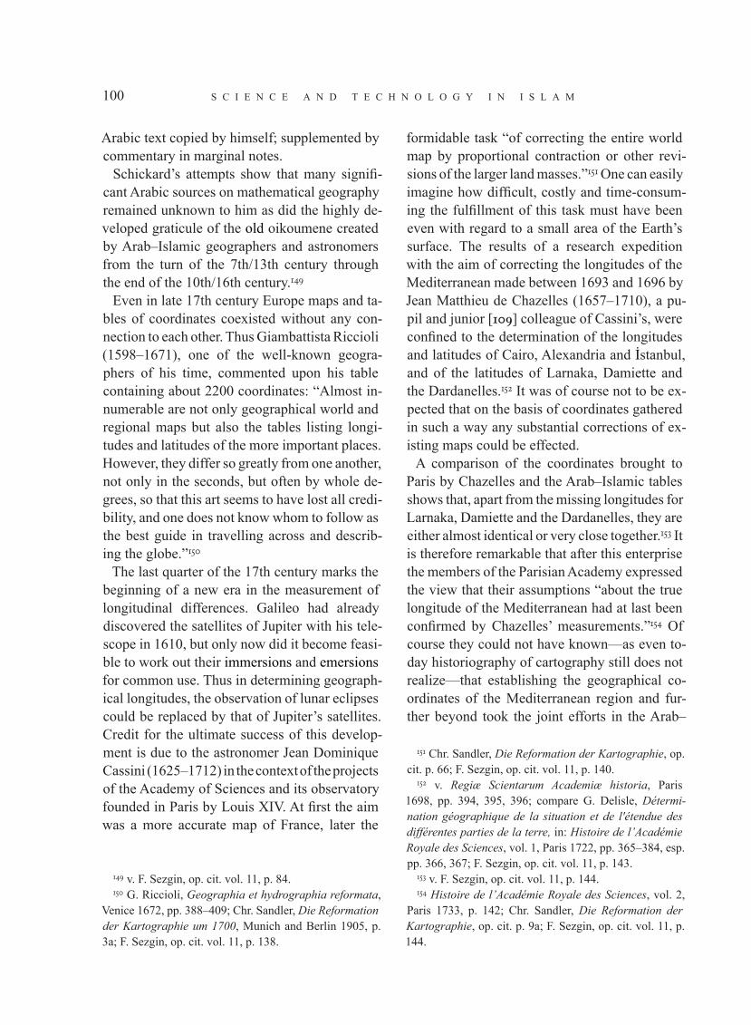
s c i e n c e a n d t e c h n o l o g y i n i s l a m100
Arabic text copied by himself; supplemented by commentary in marginal notes.
Schickard’s attempts show that many signifi-cant Arabic sources on mathematical geography remained unknown to him as did the highly de-veloped graticule of the old oikoumene created by Arab–Islamic geographers and astronomers from the turn of the 7th/13th century through the end of the 10th/16th century.149
Even in late 17th century Europe maps and ta-bles of coordinates coexisted without any con-nection to each other. Thus Giambattista Riccioli (1598–1671), one of the well-known geogra-phers of his time, commented upon his table containing about 2200 coordinates: “Almost in-numerable are not only geographical world and regional maps but also the tables listing longi-tudes and latitudes of the more important places. However, they differ so greatly from one another, not only in the seconds, but often by whole de-grees, so that this art seems to have lost all credi-bility, and one does not know whom to follow as the best guide in travelling across and describ-ing the globe.”150
The last quarter of the 17th century marks the beginning of a new era in the measurement of longitudinal differences. Galileo had already discovered the satellites of Jupiter with his tele-scope in 1610, but only now did it become feasi-ble to work out their immersions and emersions for common use. Thus in determining geograph-ical longitudes, the observation of lunar eclipses could be replaced by that of Jupiter’s satellites. Credit for the ultimate success of this develop-ment is due to the astronomer Jean Dominique Cassini (1625–1712) in the context of the projects of the Academy of Sciences and its observatory founded in Paris by Louis XIV. At first the aim was a more accurate map of France, later the
149 v. F. Sezgin, op. cit. vol. 11, p. 84.150 G. Riccioli, Geographia et hydrographia reformata,
Venice 1672, pp. 388–409; Chr. Sandler, Die Reformation der Kartographie um 1700, Munich and Berlin 1905, p. 3a; F. Sezgin, op. cit. vol. 11, p. 138.
formidable task “of correcting the entire world map by proportional contraction or other revi-sions of the larger land masses.”151 One can easily imagine how difficult, costly and time-consum-ing the fulfillment of this task must have been even with regard to a small area of the Earth’s surface. The results of a research expedition with the aim of correcting the longitudes of the Mediterranean made between 1693 and 1696 by Jean Matthieu de Chazelles (1657–1710), a pu-pil and junior [109] colleague of Cassini’s, were confined to the determination of the longitudes and latitudes of Cairo, Alexandria and √stanbul, and of the latitudes of Larnaka, Damiette and the Dardanelles.152 It was of course not to be ex-pected that on the basis of coordinates gathered in such a way any substantial corrections of ex-isting maps could be effected.
A comparison of the coordinates brought to Paris by Chazelles and the Arab–Islamic tables shows that, apart from the missing longitudes for Larnaka, Damiette and the Dardanelles, they are either almost identical or very close together.153 It is therefore remarkable that after this enterprise the members of the Parisian Academy expressed the view that their assumptions “about the true longitude of the Mediterranean had at last been confirmed by Chazelles’ measurements.”154 Of course they could not have known—as even to-day historiography of cartography still does not realize—that establishing the geographical co-ordinates of the Mediterranean region and fur-ther beyond took the joint efforts in the Arab–
151 Chr. Sandler, Die Reformation der Kartographie, op. cit. p. 66; F. Sezgin, op. cit. vol. 11, p. 140.
152 v. Regiæ Scientarum Academiæ historia, Paris 1698, pp. 394, 395, 396; compare G. Delisle, Détermi-nation géographique de la situation et de l'étendue des différentes parties de la terre, in: Histoire de l’Académie Royale des Sciences, vol. 1, Paris 1722, pp. 365–384, esp. pp. 366, 367; F. Sezgin, op. cit. vol. 11, p. 143.
153 v. F. Sezgin, op. cit. vol. 11, p. 144.154 Histoire de l’Académie Royale des Sciences, vol. 2,
Paris 1733, p. 142; Chr. Sandler, Die Reformation der Kartographie, op. cit. p. 9a; F. Sezgin, op. cit. vol. 11, p. 144.
i n t r o d u c t i o n 101
Islamic world over a period of centuries and that these data alone rendered the design up of accu-rate maps feasible.
Summarising my assessment—based on my own research—of the contribution made by European astronomers in correcting the math-ematical basis of the traditional image of the world between 1690 and 1725 I have to say that this contribution was not greater and in this ini-tial brief phase could not be greater than verify-ing a series of longitudes of prominent points on the world map on the basis of observations of the Moons of Jupiter. This made it possible to primarily assess the degree of accuracy of the west–east extension of important sections of the world map and to draw possible conse-quences for cartography. As far as we can tell to-day, longitudes of Arab–Islamic maps calculat-ed from the zero meridian running 28°30' west of Toledo prove to be several degrees too large. Thus the east coast of the Mediterranean is ca. 2°, Baghdad 3° to 3°30', Derbent (on the west-ern shore of the Caspian Sea) ca. 4°, Delhi ca. 4° and the east coast of China ca. 5°–7° too far east. A high degree of precision was achieved between Baghdad and India. In this case the deviation of Arab–Islamic maps from modern maps lies below 1°.155
When, towards the end of the 17th century, French astronomers and geographers aspired to correct or proportionately reduce the convention-al maps on the basis of newly established longi-tudes and latitudes, Jean-Baptiste Bourguignon d’Anville (1697–1782), perhaps the most im-portant of all French geographers, chose a dif-ferent approach. He himself informs us about this in his Éclaircissemens géographiques sur la carte de l’Inde (1753)156 on the cartography of the Indian subcontinent. To correct the map of India and verify its graticule and distances,
155 v. F. Sezgin, op. cit. vol. 10, pp. 160ff. ; vol. 11, p. 155.
156 Reprinted as Islamic Geography, vol. 255, Frankfurt 1997; v. F. Sezgin, vol. 10, p. 592.
[110] d’Anville consulted the Arabic–Persian and Turkish works of geographical, historical and astronomical content that were known to him at that time. As far as we know he was the first European geographer of the 18th century who consulted and evaluated so many sources from the Arab–Islamic cultural sphere. The ta-bles by Na◊¬radd¬n afl-fi‚s¬ and Ulu∫ Beg did not escape his notice, their fame having spread in Europe since the edition and Latin translation by Johannes Gravius157 of 1652. Unfortunately, however, d’Anville considered only the lati-tudes and not the longitudes of these and other Arab–Islamic tables. This was probably because he was unaware of the fact that the prime me-ridian in some tables was 28°30' west of Toledo or 17°30' west of the Canary Islands and thus about 34°50' west of Paris, rather than the 20° common with French cartographers since the last quarter of the 17th century. Consequently, the essential differences between the longi-tudes counted from the prime meridian passing through the Canary Islands and those counted from the newer prime meridian which had been shifted 28°30' west of Toledo meant nothing to him either. He knew the former from the transla-tion of the comparative table of Abu l-Fid®’. The Z¬™ -work of Ulu∫ Beg is misleading in this re-spect as the headline of the coordinate-table er-roneously states that the longitudes were count-ed from the Canary Islands.158 As far as we are aware, it is James Rennell (1742–1830), who was the first European geographer to have rec-ognised the great significance of the longitudes achieved by the “more modern” Arab–Islamic
157 Binæ tabulæ geographicæ, una Nassir Eddini Persæ, altera Ulug Beigi Tatari, London 1652 (reprint in: Islamic Mathematics and Astronomy, vol. 50, pp. 1–79).
158 We must consider this a slip. Roger Bacon already knew the prime meridian that had been shifted far to the west (supra p. 43); on the Ottoman side, I cite Mu◊flaf® b. ‘Al¬ ar-R‚m¬ (d. 979/1571) who in the preface to his table compiled in 930/1524 mentions the prime meridian shifted to the west (v. F. Sezgin, op. cit. vol. 10, p. 186).

s c i e n c e a n d t e c h n o l o g y i n i s l a m102
scholars, at least for the regions between Aleppo and Delhi (infra, p. 111 ff.)159
Since d’Anville was unable to come to terms with the longitudes known to him, he based his work on distances given in the Arabic–Persian and Turkish works of geography and history, the book by Abu l-Fid®’ being his most frequently used Arabic source.160 Through this book which he used in translation, d’Anville obtained data from works which were not accessible to him in translations or which were not extant. He also made use of quotes by Abu l-Fid®’ from books not directly belonging to the field of mathemati-cal geography but which covered areas of itiner-ary or topographical significance. It was indeed the works of Abu l-Fid®’ and al-Idr¬s¬ which he was able to use almost exclusively in his treat-ment of the map of China.
D’Anville’s expectations regarding the accu-racy of the latitudinal data contained in the “ta-bles orientaux” and their validity for large ex-panses of the Earth surface, even beyond the Indian subcontinent, seem to have been rather high. Thus he comments on the position of the pronounced point Kambaya on the west coast of India as follows: “A translation which I possess from the book by Abu l-Fid®’ registers the lati-tude of Kambaya in accordance with al-B¬r‚n¬ as 22°20' which corresponds to the map but for an insignificant difference.”161 Incidentally, the name of al-B¬r‚n¬ and his major work on astron-omy, al-Q®n‚n al-Mas‘‚d¬ was to my knowl-edge first mentioned in Europe by d’Anville .
[111] After D’Anville, James Rennell, the emi-nent—perhaps the most eminent—English ge-ographer, took up the task of verifying the carto-graphic depiction of the Indian subcontinent as known in Europe in the 1780s and aimed to im-prove it as far as possible on the basis of his own work. He took up work during his stay in eastern India in his capacity as Surveyor General of the
159 F. Sezgin, op. cit. vol. 10, p. 596. 160 ibid vol. 10, pp. 596–597. 161 ibid vol. 10, pp. 597-598.
British East India Company from 1763 to 1777. During the work on his project and especially in the course of the preparation of the accompany-ing text to the second edition of his map of India under the title Memoir of a map of Hindoostan or the Mogul Empire (London 1793)162 between 1783 and 1792, he came to realise the impor-tance of local sources. Amongst his numerous Arabic, Persian and Turkish sources, the §’¬n-i Akbar¬ by the great historian and geographer of the Mogul Empire, Abu l-Fa¥l al-‘All®m¬ (d. 1011/1602) assumes a pivotal position.
In his intention to depict India as realistical-ly as possible on the basis of maps which had been produced over the past three hundred years, and to render the country interior as accurately as possible with the help of existing sectional maps and itineraries, the §’¬n-i Akbar¬ was in-disputably a source of the first order. It provided the most reliable means of verifying informa-tion pertaining to the eleven provinces above the Dekkan, because it not only provided ex-tensive geographical descriptions and distances of routes, but also, and in particular, longitudes and latitudes.163
Moreover, Rennell—like his predecessor d’Anville—also had the modern values for the longitudes of a small number of landmarks in India at his disposal. These had been determined by observation of the Jupiter satellites. When working on the map of India, he made the capital Delhi (not Greenwich) the starting point for fur-ther calculations of distance. Besides the §’¬n-i Akbar¬, he also relied on the tables of Na◊¬radd¬n afl-fi‚s¬ and Ulu∫ Beg, but he too erroneously believed that the longitudes in those tables had been calculated on the basis of a prime meridian which passed through the Canary islands, result-ing in values that were more than 20° too great. Yet, since he calculated the longitudes back-wards from Delhi, he became convinced that
162 Reprint: Islamic Geography vols. 260–261, Frank-furt 1997.
163 F. Sezgin, op. cit. vol. 10, pp. 604–605.
i n t r o d u c t i o n 103
they were sufficient for his purposes. For the evaluation of those longitudes from west to east, he found a way to reckon them by their differ-ences from cities in the west rather than from a prime meridian.164 The manner in which Rennell based his design of the graticules for maps he revised on Arab–Islamic coordinate tables can be illustrated with an example: “Samarcand, ac-cording to the tables of Ulug Beig, is 99°16' east of the Fortunate Islands [the Canaries; as men-tioned above, the shifted prime meridian 28°30' west of Toledo escaped him]; and Aleppo, in the same tables, is 72°10': that is, Samarcand is 27°6'E of Aleppo; and this last, being 37°09'E of Greenwich (by the latest determination of the French Academy, 34°49'E of Paris), Samarcand should be in 64°15' east of Greenwich. If we reckon it from Casbin (Qazw¬n), which, accord-ing to M. Beauchamp’s [Joseph Beauchamp, the astronomer 1752–1801] observation, is 49°33'E of Greenwich; and by Ulug Beig, 14°16' west of Samarcand; the latter, by this calculation, will be in 63°49': or 26 minutes farther west, than if reckoned from Aleppo. But having with much labour investigated the particulars of the dis-tance between Casbin and Samarcand, and hav-ing compared them with the intermediate lon-gitudes and latitudes recorded in the Oriental tables [112] I am inclined to adopt 64°15', for the longitude of Samarcand. Its latitude, taken with the famous quadrant of Ulug Beig, is 39°37' and some odd seconds.”165
Rennell first tries to establish the longitude of Samarqand (99°16' in Ulu∫ Beg’s table) as reck-oned from Greenwich. Since he does not know the real prime meridian, he takes the longitude of Aleppo after Ulu∫ Beg (72°10') and 37°09', as taken with the latest method of observing the Jupiter satellites. By adding the longitudi-nal difference of both cities after Ulu∫ Beg to
164 v. F. Sezgin, op. cit. vol. 10, p. 608. 165 J. Rennell, Memoir of a map of Hindoostan or the
Mogul Empire, London 1793 (reprint: Islamic Geography, vol. 260), pp. 191–192; F. Sezgin, op. cit. vol. 10, p. 609.
the longitude of Aleppo after the modern meth-od, he obtains the longitude of Samarqand (99°16' –72°10' +37°09' =64°15'). In a sec-ond approximation he proceeds likewise, us-ing the longitudinal difference between Qazw¬n and Samarqand. If Rennell had known that the prime meridian on his Arabic–Persian tables was 28°30' west of Toledo (and thus 32°30' west of Greenwich) he could have calculated the lon-gitude of Samarqand easily by the subtraction 99°16' –32°30' =66°46'.Numerous other examples could be cited to show how Rennell, in revising the map of India and the territories to the north of it, in order to obtain as accurate coordinates as possible relied on the tables of Arab–Islamic astronomers and geographers, on the few bearings established by his European contemporaries and on distances given in parasangs or qoss (1 qoss = ca. 3 km) which he found in his sources. That the working material which he used were maps mostly based on originals from the Arab–Islamic world, shall be discussed later.
Finally I would like to quote Rennel’s own words regarding the importance of geographi-cal tables from the Arab–Islamic culture sphere for European geographers of the 18th century in verifying the accuracy of available graduaded maps: “Had Ptolemy lived in the present times, he might have expressed his wonder, that, con-sidering the advantages we possess, our maps of Asia should be so incorrect; when the tables of Abulfeda, Nasereddin, and Ulug Beig, and the History of Timur, by Sherefeddin, have been so long amongst us, in an European language.”166
I now turn to the question of the influence that Arab–Islamic geography exerted on Occidental geography through its maps. To my knowledge, Joachim Lelewel, an historian of geography and also a capable Arabist, was the first to address the question of the origin of those maps which, from the turn of the 13th to the 14th century, de-
166 J. Rennell, Memoir, op. cit. vol. 1, p. 199; F. Sezgin, op. cit. vol. 10, p. 610.

s c i e n c e a n d t e c h n o l o g y i n i s l a m104
lineated the shape of the Mediterranean (often along with the Black Sea) almost perfectly. In Lelewel’s view, these maps, usually referred to as nautical charts and, in the course of time, also as portolan charts, were originally based on a graticule established by means of geographical coordinates, the same graticule that was also the basis of further developments. Lelewel assumes it was created by “the Sicilian geographers” (be-tween 1139 and 1154) improving upon the ma-terial inherited from Arab geographers and their Greek predecessors in the form of al-Idr¬s¬’s ge-ography and maps.167 The debates [113] on the origin of the portolan charts which broke out af-terwards, continue even today and views are of-ten diametrically opposed to another.168 Arabists, independent of Lelewel, have occasionally ex-pressed the view that these maps were derived from those of al-Idr¬s¬ (1154ce).169 Their efforts have however hardly been noticed by the vast majority of non-Arabist scholars. The reasons why this majority would not recognise or ac-knowledge the dependence of the maps on Arabic originals are many. Despite all efforts on the part of historical research in natural science to set this straight, a stubborn approach still persists to see the inherited knowledge of humankind only from an Eurocentric point of view. The clarity achieved by research in the history of science about the tremendous progress made by scienc-es in the Arabic-Islamic world—which, at the time when those almost perfect maps emerged, had already reached a very high stage in its de-velopment—was unfortunately neglected due to such preconceptions. It was a time that—in terms of history of science—falls in the period of reception and assimilation of Arab–Islamic sciences in Europe, when Europeans were ac-quiring new knowledge.
167 J. Lelewel, Géographie du moyen âge, op. cit. vol. 1, introduction pp. lxxxix–lxxx, vol. 2, p. 17; F. Sezgin, op. cit. vol. 10, p. 289.
168 v. F. Sezgin, op. cit. vol. 10, pp. 285–300. 169 ibid, vol. 10, pp. 300–310.
At first no significant evidence supporting the view that the so-called portolan charts were based on Arabic originals was at the dispos-al of Arabists. Moreover, hardly any attempt was made by Arabists to give an overview of Arab–Islamic cartography based on mathemati-cal–astronomical principles and thus to instigate a discussion on its impact in the context of the process of reception and assimilation of Arab–Islamic science in the West. The motive for this passive attitude amongst Arabists was not so much the lack of convincing cartographic ma-terial but rather the notion which had impercep-tibly become axiomatic in the West during the 19th and 20th century that the concrete carto-graphic representation of the Old World and its elaboration from the 13th century was a prod-uct of the western world and that it could not be otherwise. Like most of his contemporaries, the author of these lines was also conditioned by school and conventional wisdom in favour of this notion. When I consider it unjustified, his-torically unfounded and even absurd today, then I was led to this perception gradually and only in the last couple of years after long occupation with the subject; and in the beginning I had the good luck to happen upon the world map of the geographers of Caliph al-Ma’m‚n (r. 198/813–218/833). The results of my research were pub-lished in 2000 under the title Mathematische Geographie und Kartographie im Islam und ihr Fortleben im Abendland as volumes 10 to 12 of the Geschichte des arabischen Schrifttums.170 Some of the reasons that caused me to revise the received notion, which I myself carried around for half a century too, I shall discuss here be-cause they are relevant for the question of the reception of Arab–Islamic maps in the West.
According to present knowledge, the old-est map originating in Europe in which traces of Arab influence are recognisable was made
170 Engl. transl. entitled Mathematical Geography and Cartography in Islam and their Continuation in the Oc-cident, 2 vols., Frankfurt 2005–2007

i n t r o d u c t i o n 105
by a Jewish apostate known by his christian name Petrus Alphonsus. It is a schematic chart of the world included in a little astronomy book he wrote around 1110 CE. The map is southern-oriented as was the Arab custom and shows the Arabic division in seven climates and the name of the city of Aren (Arin).171 [114] Clues point-ing to an Arab influence can also be found in the famous world map by John of Wallingford (d. 1258).172
One world map to which insufficient attention was paid by history of cartography appeared in the Livres dou Tresor (ca. 1265) by the Italian scholar Brunetto Latini,173 interestingly without any specific reference to the text.174 Its configu-ration, the delineation of oceans, mountains and rivers and the shape of the continents cause us to assume a model in the tradition of the world maps of the Ma’m‚n geographers and al-Idr¬s¬, but already showing some further development regarding the shape of the Mediterranean, the Black Sea and Asia Minor. The image of the world as depicted in this map, preserved in Brunetto Latini’s work—as a whole and in de-tail—must have been perceived as entirely new and strange in the non-Spanish West, as can
171 v. C. R. Beazley, The Dawn of Modern Geography, vol. 2, London 1897, pp. 575–576; C. H. Haskins, Stud-ies in the History of Mediaeval Science, New York 1924, pp. 113–119; R. Mercier, Astronomical Tables in the Twelfth Century, in: Adelard of Bath. An English Scientist and Arabist of the Early Twelfth Century, ed. Ch. Burnett, London 1987, pp. 95–96; F. Sezgin, op. cit. vol. 10, pp. 207–208; vol. 12, map 51, p. 110.
172 A.-D. von den Brincken, Mappa mundi und Chrono-graphia. Studien zur imago mundi des abendländischen Mittelalters in: Deutsches Archiv zur Erforschung des Mittelalters (Cologne and Graz) 24/1968/118–186, esp. pp. 148-149; F. Sezgin, op. cit. vol. 10, pp. 208, 326.
173 v. F. Sezgin, op. cit. vol. 12, map 55, p. 114. 174 A.-D. von den Brincken, Die kartographische
Darstellung Nordeuropas durch italienische und mal-lorquinische Portolanzeichner im 14. und in der ersten Hälfte des 15. Jahrhunderts, in: Hansische Geschichts-blätter (Cologne and Graz) 92/1974/45–58; F. Sezgin, op. cit. vol. 10, pp. 223, 327–331.
be shown by a comparison with all other sur-viving European world maps of the 13th cen-tury. A comparison of this map with the depic-tion of the oikoumene by Latini’s contemporary Albertus Magnus175(d. 1280) or also in the world map of Petrus de Alliaco176 (1410), active in the 14th century, would alone suffice to show how unusual this depiction must have been for the West, leaving aside that the maps by Albertus Magnus and Petrus de Alliaco also betray traces of Arabic astronomical–cosmographical sourc-es.
The second oldest world map known to us that displays a striking similarity with the Ma’m‚n and Idr¬s¬ maps dates from around 1320. It bears the names of Marino Sanuto and Petrus Vesconte as authors. In ignorance of the Ma’m‚n map, re-cent research has related this world map directly and solely to the al-Idr¬s¬ map.177
The world map by Sanuto and Vesconte with all its versions is commonly grouped with the so-called portolan charts. The question of the lat-ter’s origin has been debated since ca. 1850 and answered in various ways. We are of the opinion that these maps at their time represented the lat-est stage of development in the history of cartog-raphy, accomplished by humankind as a whole—a development which had been dominated for the past five hundred years by the Arab–Islamic world, and which was to be dominated by it for another three hundred years, viz. from around 800 until 1600 CE. The reasons for my conviction that the remark-able accuracy of the coastlines and the longi-
175 v. F. Sezgin, op. cit. vol. 10, pp. 220-223, vol. 12, map 53, p. 111.
176 ibid, vol. 10, p. 216, vol. 12, map 54, p. 111. 177 v. K. Miller, Mappae arabicae, vol. 1, Stuttgart 1926
(reprint: Islamic Geography, vol. 240) p. 51; T. Lewicki, Marino Sanudos Mappa mundi (1321) und die runde Weltkarte von Idr¬s¬ (1154), in: Rocznik Orientalistyczny (Warsaw) 38/1976/169–195; Fr. Wawrik, Die islamische Kartographie des Mittelalters, in: Kultur des Islam, Re-ferate einer Vortragsreihe an der Österreichischen Natio-nalbibliothek, 16.–18. Juni 1980, ed. by O. Mazal, Vienna 1981, pp. 135–156, esp. pp. 152–153; F. Sezgin, op. cit. vol. 10, pp. 291, 293–294.

s c i e n c e a n d t e c h n o l o g y i n i s l a m106
tudinal proportions in the larger part of the so-called portolan charts was achieved during the Arab–Islamic period of the history of cartog-raphy shall be explained later, for the moment I would like to refer only to some of the indi-rect arguments presented in the first part of this introduction [115] (supra p. 50 ff.); right now I shall briefly introduce the three surviving maps, each of which marks an important stage in the development prior to 1300 CE.First, the world map of the geographers of Caliph al-Ma’m‚n from the first quarter of the 3rd/9th century. A copy dated 740/1340 certain-ly fails to reproduce the original in all its splen-dour (infra III, 24), yet it and the map recon-structed after the surviving original coordinate tables (infra III, 25) show that this important work represents one of the defining stages in the universal history of cartography. The map is based on the one by Marinus (1st half of the 2nd century CE), on the Geography of Ptolemy (2nd half of the 2nd century CE) and on the results of the measurements and surveys made by a large group of scholars commissioned by the Caliph. It goes without saying that, in the first attempt at correcting and completing the inherited picture of the world, they were confined to gradual, if considerable, improvements. Their most strik-ing contribution to the new world map consists in the following innovations which became piv-otal for subsequent developments. Foremost, the Ma’m‚n geographers conceived the oikoumene as surrounded by water and Africa as circum-navigable in the South, as opposed to Marinus’s and Ptolemy’s assumption of one single, con-nected continent in which the Indian Ocean forms a land-locked sea. Moreover, the Ma’m‚n geographers reduced the excessive longitudinal extension of the Mediterranean in Ptolemy from 63° to 52° or 53° and made certain corrections in its cartographic depiction.
The next map, representing a further stage in the development, is the one by al-Idr¬s¬ dating from 549/1154 (infra III, 26ff). It is established today that al-Idr¬s¬ must have had the world
map of the Ma’m‚n geographers as a model and not, as was often claimed,178 the one by Ptolemy (which most probably never existed). Despite certain drawbacks compared to the Ma’m‚n map, al-Idr¬s¬’s world map shows a better de-lineation of the Mediterranean, of Europe, and particularly of Central, North and North-East Asia. These advances, made in the course of the roughly 325 years since the Ma’m‚n map, dem-onstrate that there was a lively development—especially regarding Asia—in the cartographic depiction of the Earth surface.
One of the surviving cartographic documents for the third stage of the development on the way to the so-called portolan charts is an Arabic–Maghribi map which depicts the coastlines of the western quarter of the Mediterranean with all the islands, the west coasts from Gibraltar up to northern France and parts of the English and Irish coast almost perfectly.179 With a pass-ing reference to the Chinese world map, the one by Na◊¬radd¬n afl-fi‚s¬ and the didactic scheme of the Mediterranean and the Black Sea by Quflbadd¬n a· -∞¬r®z¬, all mentioned above (p. 49) and suited to support the notion sketched here regarding the stages of development of car-tography in the Arab–Islamic world preceding the so-called portolan charts which appeared in Europe around 1300, we shall give some exam-ples of the simultaneously created mathemati-cal–astronomical basis for this development as well. In the first place, we shall consider the length of the great axis of the Mediterranean and the differences in longitude between some of its important coastal cities.
178 v. e.g., M.A.P. d’Avezac, Coup d’œil sur la projec-tion des cartes de géographie, in: Bulletin de la Société de Géographie (Paris) 5e série, 5/1863/257–485, esp. pp. 293–294; F. Sezgin, op. cit. vol. 10, p. 286.
179 v. F. Sezgin, op. cit. vol. 11, pp. 27–31, vol. 12, map 35, p. 74.

i n t r o d u c t i o n 107
The values are taken from tables featuring the extensive corrections regarding the longitudes of cities between Toledo and Baghdad which had been made from the first half [116] of the
5th/11th century. Thus the longitudinal differ-ences between six cities according to the table of Abu l-ºasan al-Marr®ku·¬180 (d. in or after ca. 660/1260 or ca. 680/1280)are as follows:
180 v. F. Sezgin, op. cit. vol. 10, pp. 168–173.
Tangier L 24°10' — Antioch 69°34'Tangier L 24°10' — Rome L 43°00'Toledo L 28°00' — Alexandria L 63°00'Toledo L 28°00' — Constantinople L 60°00'Alexandria L 63°00' — Antioch 69°34'
Longitudinal difference45°23'18°50'35°00'32°00'06°45'
Modern value42°00'18°20'36°00'33°00'06°05'
Tangier 25°00'Tangier 25°00'Toledo 28°00'Toledo 28°00'Alexandria 61°20'
— Antioch 69°04'— Rome 45°00'— Rome 45°00'— Alexandria 61°20'— Antioch 69°04'
Longitudinal difference44°04'20°00'17°00'33°20'07°44'
Modern value42°00'18°20'16°32'33°55'06°05'
The length of the Mediterranean between Tangier and Antioch, still at 45°23' in Abu l-ºasan al-Marr®ku·¬, appears once more reduced and improved as 44°00' 181 with his younger col-
181 ibid, vol. 10, p. 165.
league MuΩammad b. Ibr®h¬m Ibn ar-Raqq®m182 (d. 715/1315). The resulting longitudinal differ-ences are:
182 ibid, vol. 10, pp. 166, 231.
The substantial reduction of geographical lon-gitudes carried-out in the Arab–Islamic world reached Europe relatively early on, at least through the table by Ibn ar-Raqq®m. This is included in an anonymous Latin text entitled Latitudo et longitudo regionum sicut continetur in Libro alg’alien.183 Even though this manu-script may well date from the 14th century, nei-ther that nor any other coordinate table found any use in European cartography for centu-ries. Wilhelm Schickard and Willem Janszoon Blaeu were the first in Europe to point out—as
late as 1630—the distorted representation of the Mediterranean on maps,184 and it took until about 1700 before the length of the Mediterranean was established with tolerable accuracy.185 But how far removed Europe was from an exact math-ematical representation of the Mediterranean, even in the second half of the 17th century, is il-lustrated by an overview of the divergent values recorded for the difference in longitude between Rome and Toledo which Michael Florentius van Langeren presented to the [117] Spanish King
183 MS Vienna, Nationalbibliothek 2452, cf. F. Sezgin, op. cit. vol. 10, p. 231.
184 F. Sezgin, op. cit. vol. 11, pp. 129,132.185 ibid, vol. 11, p. 132 ff.
180 v. F. Sezgin, op. cit. vol. 10, pp. 168–173. 181 ibid, vol. 10, pp. 166, 231.182 ibid, vol. 10, p. 165.
s c i e n c e a n d t e c h n o l o g y i n i s l a m108
Philipp IV (d. 1665): Blaeu had assigned it 17°20', G. Mercator 20°, Ph. van Lansberge 21°, Tycho Brahe 21°30', Cl. Ptolemy 22°40' (for which read 26°40') and A. Maginus 29°40'. In reality it is 16°32'.186
At this point the discussion of the depiction of the Mediterranean in Arab cartography as adopt-ed in the West could be closed, if the unrealis-tic notions purported by historians of cartogra-phy were restricted to the origin of the so-called portolan charts of the Mediterranean. But such notions are also applied to a larger geographical area which is not believed to have been sailed by European mariners and the maps of which do not fall, strictly speaking, in the category of Mediterranean portolans. Thus one tacitly sup-ports the common practice of not questioning the origins of maps of remote countries and entire continents such as Asia and Africa, or, should they be questioned, to assume they are original works by European cartographers who are sup-posed to have created them on the basis of infor-mation gathered by some sort of inquiries.
The map bearing the name of Giovanni da Carignano, who was the rector at the Marcus Church in Genoa and died in 1344, can serve as an interesting example. It is supposed to have been made around 1311 187 and comprises, be-sides the Mediterranean, the Black Sea, Europe and North Africa, Anatolia, Iraq and Persia with the Caspian Sea and Lake Urmia. This map, lost during World War II, was dealt with at length by Theobald Fischer in 1885.188 According to his opinion, the considerable part of the surface of the Earth depicted here was rendered quite accu-rately by Carignano in Genoa solely on the basis
“of questioning travellers” or by means of other
186 P. J. H. Baudet, Leven en Werken van Willem Jansz. Blaeu, Utrecht 1871, p. 77; F. Sezgin, op. cit. vol. 11, p. 132.
187 v. F. Sezgin, op. cit. vol. 12, p. 129.188 In his Sammlung mittelalterlicher Welt- und
Seekarten italienischen Ursprungs und aus italienischen Bibliotheken und Archiven, Marburg 1885 (reprint: Am-sterdam 1961 without maps), p. 118 ff.
“inquiries”. Without repeating my criticism of his reasoning and motives,189 I content myself here with the concluding remark that most of Fischer’s finds regarding Carignano’s map actu-ally point to at least one map representing more or less the latest development of Arab–Islamic cartography in the second half of the 7th/13th century that served as a model for Carignano. It may be expected that the shapes of the Caspian Sea and Lake Urmia in this original already re-flected a further development of cartographic depiction than the state we know e.g. from the Idr¬s¬ map of 549/1154. Carignano might have used the Idr¬s¬ map as well, but his main mod-el must have been a more recent map from the Arab–Islamic world in which cities were includ-ed that have been named only since the 6th/12th century by the Anatolian Seljuks.190
A cartographic phenomenon to which in my view the historians of the subject did not pay adequate attention consists in the fact that one of the ‘portolan’ charts, viz. the one by Sanuto and Vesconte (infra III, 14), which dates from 1320 at the latest, already shows Africa with a circumnavigable shape, and that in another one from around 1351 the delineation of Africa shows signs of considerable improvement.191 This attempt at correction becomes significant considering also the other parts of the carto-graphic work connected to it, known in modern literature as the Medici Atlas:192 this atlas [118] also features a fairly realistic delineation of the Caspian Sea193 and the triangular shape of the Indian peninsula,194 besides some quite perfect regional maps of the Mediterranean and the Black Sea.
As far as I know, the Sinologist Walter Fuchs is the only scholar so far to have turned against the assumption that such a delineation of Africa
189 v. F. Sezgin, op. cit. vol. 10, pp. 332–335.190 ibid, vol. 10, p. 335.191 ibid, vol. 10, p. 549, vol. 12, p. 137.192 ibid, vol. 12, maps 71 a–h, pp. 136-140.193 ibid, vol. 10, p. 475.194 ibid, vol. 10, p. 568.
i n t r o d u c t i o n 109
in a European map could be due to the origi-nal achievements of a European map–maker. He came to this conclusion through his study of the Chinese world map from the turn of the 14th century which had been drawn on the basis of an image of the world dating from the end of the 13th century that had reached the eastern Mongol empire from the Islamic world and astonishes us with a depiction of the Mediterranean quite close to reality and the delineation of the trian-gular shape of South Africa. Fuchs195 emphasis-es that it is hard to believe that such a depiction could have been a coincidence. He would tend to assume that the cartographic heritage of the Arabs had only been incompletely handed down and that those cartographers did not always re-flect the current level of experience of their sea-farers.
Unfortunately, it happens not infrequently that new elements appearing on European maps of the 14th century—regardless of what name the map may bear—are traced back to clues in Marco Polo’s travelogue, even if these are quite meagre or insignificant.196 I assume it is unnec-essary to argue against the naïve view that it was possible to draw a tolerably realistic map of any part of the surface of the Earth on the ba-sis of Marco Polo’s scattered, casual and often incorrect geographical information, or in fact of any observations made by travellers. The role played by Marco Polo or any other European Orient-traveller in the history of cartography can only have consisted in their bringing home car-tographic material from foreign countries. Thus it is not surprising that Marco Polo, the Venetian businessman who visited on his outward jour-ney the realm of the Ilkh®ns (1272) and on his homeward journey (1294/1295) several cul-tural centres of the eastern Islamic world such
195 Was South Africa already known in the 13th century? in: Imago Mundi (London) 10/1953/ 50–51; F. Sezgin, op. cit. vol. 10, pp. 323, 563.
196 v. F. Sezgin, op. cit. vol. 10, pp. 318, 320, 337, 469, 484, 533, 556, 558, 563, 569, 570, vol. 11, pp. 102, 409, 414.
as Tabr¬z, where mathematical geography was cultivated in the 13th century, would encounter world maps and nautical charts of which he then saw to procure copies and sketches.197
In the early 1930s, one map became known while four others followed in subsequent years, which Marco Polo is said to have had in his possession during his journey to Asia.198 They show roughly drawn coastal lines of South and East Asia, but also a remarkably accurate ren-dition of the Indian subcontinent and of the Malayan Archipelago. Of importance to us also are Arabic details and their Italian translations found on two maps surviving in a dilettante copy, one of which states that the map had been presented to Marco Polo in 1287 (erroneous-ly 1267 in the manuscript) by a Syrian captain called Sirdumab (?), who sailed between Syria (Arabia) and the Far East for thirty years.199 I be-lieve that these sketches represent the rudimen-tary outlines of some Arab–Persian world maps and nautical charts known to Marco Polo, the likes of which, in more developed formats and with greater detail, repeatedly found their way [119] to European cartographers over the centu-ries.200
In the course of the reception and revision of models from the Arab–Islamic area, count-less non-graduated world maps were produced in Europe during the 14th and 15th centuries. Surely, not all of these maps were copied from originals, but frequently copies of copies and not free from the particular map–maker’s fancy. Only one of the most famous specimens shall be mentioned here, the map by Fra Mauro, a monk from the Camaldulensian (Benedictine) monas-tery on Murano off Venice, made between 1457 and 1459 upon the suggestion of the Portuguese
197 ibid, vol. 10, pp. 315-316.198 ibid, vol. 10, p. 316.199 ibid, vol. 10, p. 317.200 ibid, op. cit. vol. 10, p. 318.

s c i e n c e a n d t e c h n o l o g y i n i s l a m110
King Alfonso V (1433–1481).201 In comparison the configurations of the map and its depiction of the three continents with the Mediterranean and the Black Sea turn out akin to the above-mentioned world maps by Brunetto Latini and Sanuto-Vesconte which in turn, as shown above, were based on Arab models. A new element com-pared to the two predecessors appears on Fra Mauro’s map in the fairly accurate shape of the Caspian Sea. It is to be noted that its north–south axis is rotated counter-clockwise by about 70°. In all probability this rotation is a consequence of fixing-a regional map of the Caspian Sea into the world map forming the basis. It should also be mentioned that the map is southern-oriented as was the Arab custom and that more recent re-search pointed out the Arabic origin of the desig-nation of the Atlantic in it: “Ocean of Darkness” (al-BaΩr al-mu˙lim).202 Moreover, it is stated in an inscription that an (Arab) vessel circum-navigated the South-African cape from the east and sailed into the Ocean of Darkness cover-ing about 2000 miles in 40 days in unfavour-able voyage.203 R. Hennig204 found that in this report “the most important fact from the point of cultural history is that Fra Mauro had no res-ervations referring to Africa as circumnavigable in the south, on the basis of those Arabic reports about sea voyages around 1420.” Moreover, a view circulated in the 16th century to the effect that Fra Mauro had compiled his world map on the basis of a “beautiful and very old world map and nautical chart” which Marco Polo and his father had brought from China.205 I understand that this would have been an Arab–Persian map
201 v. R. Hennig, Terrae incognitae. Eine Zusammen-stellung und kritische Bewertung der wichtigsten vor-columbischen Entdeckungsreisen an Hand der darüber vorliegenden Originalberichte, vol. 4, Leiden 1956, p. 55.
202 v. R. Hennig, op. cit. vol. 4, p. 48.203 ibid, pp. 45, 49.204 ibid, p. 54.205 v. The celebrations of the 700th anniversary of
Marco Polo’s birth at Venice, in: Imago Mundi (London)
acquired by the Polos in an Islamic country on their (supposed) return from China, whereby the actual model used by Fra Mauro does of course by no means necessarily stem from the Polos.
A certain degree of familiarity with the new image of the world created by Arab–Islamic geographers brought about an augmentation of knowledge in the field of mathematical ge-ography in Europe, yet insecurity and confu-sion spread as well, caused by the edition of the Ptolemaic Geography in the Latin translation of around 1406, in print from 1477. The length of the Mediterranean—ca. 53° on the world map of the Ma’m‚n geographers, the actual value be-ing 42°—now appeared as 63° in the translat-ed work of Ptolemy with its tables, and on the maps reconstructed according to those tables by the Byzantine Maximos Planudes around 1300 CE. The distance of India from the Canary Islands found on those maps was 125° (instead of 115° according to the Ma’m‚n geography); Asia [120] was connected in the south-east to Africa, the Indian Ocean thus turning into a land-locked sea; the Asian continent stretched in the east and north-east beyond L180°, the Caspian Sea spread about 23° from east to west in the shape of a melon, etc. Map–makers and cosmographers had the choice of whether they would stick to the version of the Ma’m‚n ge-ographers or would adopt that of Ptolemy. One of the key elements of the Arab-Islamic image of the world, namely that Africa is circumnavi-gable in the south and that the Indian Ocean is part of the ocean surrounding the oikoumene, did, however, prevail against the Ptolemaic view. A world-map 206 which appeared around 1483–1488, shortly after the first edition of the Latin translation of Ptolemy’s Geography, is pe-culiar in combining the Arab–Islamic concept of an oikoumene surrounded by ocean with the Ptolemaic view of the Indian Ocean as a land-
12/1955/139–140, esp. p. 139b; F. Sezgin, op. cit. vol. 10, pp. 318–319.
206 v. F. Sezgin, op. cit. vol. 11, p. 86, vol. 12, p. 124.

i n t r o d u c t i o n 111
locked sea. On the one hand it displays a rather good knowledge of Europe and a largely correct shape of the Caspian Sea, whilst on the other hand reflecting the Christian view that Paradise lies to the east of the oikoumene where the four main rivers of the Earth rise.207
This ambivalence noticeable in European world maps since the introduction of Ptolemy’s Geography could, however, not remain deci-sive for the new development which had be-gun in Europe in the 13th century. In fact, the Ptolemaic image of the world could not hold its ground for long, or to be precise, no longer than half a century, against the one found on the maps which reached Europe from the Arab–Islamic area mainly through Portuguese expeditions. Already with the first voyage of Vasco da Gama an almost perfect representation of Africa and of the western part of the Indian Ocean with the Indian peninsula reached the Iberian peninsula and Italy. This was followed by further maps, particularly an atlas with 26 regional maps writ-ten in Javanese script; the representation of the Indian Ocean in this atlas, inter alia, testifies to the high level achieved in the cartographic survey of the Earth surface in the Arab–Islamic area before ca. 905/1500. The Portuguese sea-farers in the Indian Ocean make no secret of having brought maps from there to Portugal and of having encountered advanced compasses and a highly sophisticated navigation amongst Arab seafarers. Moreover, Portuguese sources give detailed information to the effect that maps of the Indian Ocean with circumnavigable shapes of Africa got into Portuguese hands from the first half of the 15th century.This ultimately en-couraged people in Portugal to head for India on the sea route which had long been known.208
Around 1550, at a time when the regress ion in the depiction of the world map that had be-gun in Europe with the translation of Ptolemy’s Geography still prevailed, the maps brought
207 v. F. Sezgin, op. cit, vol. 11, p. 86.208 ibid. vol. 11, pp. 358–362.
by the Portuguese began to make their impact. From the viewpoint of the history of cartogra-phy one can hardly overemphasise the impor-tance of what we hear in this connection from Gian Battista Ramusio (1485–1557), a Venetian with a special interest in geography and travel accounts:209 “Since the representation of Africa and India on the maps in Ptolemy’s Geography appeared very imperfect to me in view of the considerable knowledge about these regions which we nowadays have, I thought it expedient and not a little useful to collate the news from authors of our times who have travelled the parts of the Earth mentioned [121] and treated them in detail and to illustrate them with nauti-cal charts of the Portuguese, so that other such maps can be produced to the utmost satisfac-tion.” The maps reproduced by Ramusio com-prise: 1) Africa, 2) Arabia-Persia-India, 3) the Isole Moluche (Southeast Asia) and 4) a region-al map of Africa. Besides the fact that all maps are south-oriented as was the Arab custom, their toponomy as well as the scales of longitudes and latitudes leave no doubt as to their Arabic origin.210 Yet, rather than the maps supplied by Ramusio himself, it was the map of Asia by a friend of Ramusio, Giacomo Gastaldi,211 that perplexed contemporary cartographers and still astonishes historians of cartography today. It appeared in the years 1559–1561 under the in-fluence of Ramusio’s maps. How Gastaldi, an engineer from Venice, who had dedicated him-self to the publication of Ptolemaic maps since 1539, suddenly came to prefer an entirely differ-ent representation of Asia remains an inexplica-ble phenomenon in the history of cartography to this day. His contemporary, the well-known cartographer Abraham Ortelius, who made his own version of Gastaldi’s map with a few minor
209 Navigationi et viaggi, vol. 1, Venice 1563 (reprint: Amsterdam 1970), dedicatoion, p. 2; F. Sezgin, op. cit. vol. 11, pp. 99–100.
210 F. Sezgin, op. cit. vol. 11, pp. 100–103.211 ibid, vol. 12, map 113b–d pp. 177–179.

s c i e n c e a n d t e c h n o l o g y i n i s l a m112
changes, remarks in the bottom right-hand cor-ner of his map of Asia:212 “[Herewith] we offer to the inclined reader a newer depiction of Asia which Jacobus Gastaldus, a man of great merit in the field of geography, [prepared] according to the tradition of the Arabian cosmographer Abu l-Fid®’. Guillaume Postel, the famous mathemati-cian who was also proficient in many languages, including Arabic, has brought this author from the Middle East to our Europe…”.
I see the significance of this remark with re-gard to the history of geography in the fact that Ortelius obviously thought the appearance of a map of Asia like Gastaldi’s was possible only on the basis of the Arab tradition. Whether the coordinates in Abu l-Fid®’’s book would have sufficed to design the configuration of a map or whether they were indeed congruent with Gastaldi’s map of Asia he certainly did not ques-tion. Neither could any one of his predecessors, contemporaries or successors in Europe have known that the geographical coordinates filed by Abu l-Fid®’ in a comparative table date from before the turn of the 13th to the 14th century and do not yet take into account the reduction of longitudes through the shift of the prime merid-ian to a position 28°30' west of Toledo. After all, even Ortelius did not know that Gastaldi had for his part used one or several Arab maps as mod-els which already complied with the prime me-ridian 28°30' to the west of Toledo.213
The reaction of his contemporaries to the car-tographic data provided by Gastaldi in his maps of Asia must have been tremendous; this can be recognised, inter alia, from the fact that three years after the maps had been given pride of place on the wall of the Senate hall in Venice, extensive tables were compiled of the identifi-able places with their coordinates.214
The most striking difference between the older (“Ptolemaic”) and the younger (“Arabic”) depic-
212 F. Sezgin, op. cit. vol. 12, p. 182.213 ibid, vol. 11, pp. 99–116.214 ibid, vol. 11, p. 108.
tion of the Earth surface as applied by Gastaldi consists, in my opinion, in the fact that in the latter, Asia is no longer spread all over the map right to the edges in the north and the east as part of one continuous land mass, but has been assigned an oval, circumnavigable shape. This representation of the north-eastern edge of Asia after Arabic models which had already appeared sporadically in earlier European [122] world maps, now gains general currency on contem-porary and subsequent maps. This includes not only the circumnavigability of Asia in the north-east, but also its reduced size and its saddle-like shape, features not derived from the Ma’m‚n map. In this respect the Idr¬s¬ map proves to be the oldest surviving model. Without repeating my explanation here,215 I may state that this im-portant innovation dates back to the period be-fore al-Idr¬s¬ (549/1154) and continued to influ-ence the development of the cartography of Asia in subsequent centuries.216 In this connection we should also mention the dispute kindled around 1570 on the question whether Asia was circum-navigable in the north, which was denied by G. Mercator and A. Ortelius at that time.217
Ortelius’s remarks in the bottom right-hand corner of his map of Asia and the question of the Arabian source of Gastaldi’s maps of Asia were repeatedly discussed in the 20th century.218 A convincing answer was not to be expected from the conventional opinion, that the portolan and world maps originated in Europe as long as the state of the cartographic–historic research did not permit consideration of an influence exerted by maps from the Arab–Islamic world. To make matters worse, there was almost no knowledge of the enormous development of mathematical geography in the Islamic world which could have provided the key to solving the entire com-
215 ibid, op. cit. vol. 11, p. 119.216 ibid, vol. 11, pp. 108-109.217 ibid, vol. 11, p. 80.218 ibid, vol. 11, pp. 104–107.

i n t r o d u c t i o n 113
plex of the graticules on which European maps were based or with which they were supplied.219
The importance of the innovations which Gastaldi introduced into the European cartog-raphy of the old oikoumene cannot be overes-timated. Its greatest effect seems to have been caused by the maps of Asia by Abraham Ortelius and Gerhard Mercator. Ortelius gave the map of Asia a globular projection with some reduction in topographical errors. The extension of Asia between the eastern edge of the Mediterranean and the southern tip of India given on Gastaldi’s world map as ca. 47° or 48° was adopted almost unaltered by Ortelius for his globular projection. In Mercator the same section in stereographic projection is reduced to 44°.220
Historians of geography have found various different ad-hoc explanations for the correc-tions on the graticules of the world maps which appeared subsequent to Gastaldi’s maps of Asia. Not wanting to repeat their views, I should rather like to give an account of the impression I gained during my study of mathematical geography and cartography in Islam and their continuation in the West.221 The corrections made by 16th century European cartographers to fundamen-tal dimensions of the world maps circulating in Ptolemy’s name were neither undertaken on the basis of coordinates which had been taken from tables and appeared to be superior, nor on co-ordinates arrived at by original measurements. They were the result of adopting maps from the Arab-Islamic world which were seen as superior. To my present knowledge Kepler is the first to have endeavoured to produce a certain degree of congruence between the representation of the Mediterranean as found in current maps and the coordinates accessible to him on tables. The fruits of these endeavours which are known to us are a world map and a table of geographical places with [123] an explanatory introduction.
219 F. Sezgin, op. cit. vol. 11, p. 108.220 ibid, vol. 11, p. 111.221 ibid, vol. 11, p. 116.
Kepler had announced this map but did not live to produce it, hence it was drawn by his friend Ph. Eckebrecht, a citizen of Nuremberg, and published in 1630. The basic dimensions of the Old World such as the distances of the southern tip of India from the western edge of the Medi-terranean, the longitude of the major axis of the Mediterranean and the distance between the east coast of Africa and the west coast of Sumatra at the Equator are similar, on this world map, to those on the maps of his predecessors Gastaldi, Ortelius and Mercator. His innovation to cartog-raphy lies in his treatment of the western basin of the Mediterranean.222
Kepler left behind quite a heterogeneous ge-ographical table of places in which he tried to harmonise Ptolemaic coordinates with those stemming from the first reduction of the length of the Mediterranean by 10°, effected by Arabic geographers. As a result we see that in his table and his map the eastern basin of the Mediterra-nean is about 10° too large—in compliance with the Ptolemaic figures, whereas the length of the western basin with the reduction by 10° is in ac-cordance with the most advanced maps from the Arab–Islamic area and almost reaches the actual values. Fortunately, this distorted representation of the Mediterranean did not find any notable dissemination.223
Subsequent to Gastaldi’s maps of the years 1559–1561 there was no substantial progress made in the development of the fundamental di-mensions and the cartographic shape of promi-nent parts of the Old World, with the exception of the northern parts of Europe, until about the middle of the 17th century. Variations are re-stricted to decorative features or the mechanical shifting backwards and forwards of the African west coast in the graticule of the maps.224 Only in the course of increased contacts of Eu-ropean scholars with the Islamic world, shortly
222 ibid, vol. 11, pp. 121–122.223 ibid, vol. 11, p. 124.224 ibid, vol. 11, p. 117.

s c i e n c e a n d t e c h n o l o g y i n i s l a m114
before the middle of the 17th century, did the European maps of Asia begin to attain a higher quality. Part of this consisted in the fact that it became more common to mention where the maps, brought from eastern countries or evalu-ated locally, had originated. In this respect the map of Persia brought back by Adam Olearius (1599–1671) figures, in my view, as a milestone. This scholar from Gottrop knew some Arabic and joined a trade delegation headed by Otto Brügmann travelling to Persia via Russia.
The journey lasted from 22nd October 1636 to 1st August 1639 and the description was pub-lished, together with the map, in 1647.225 The reaction of his colleagues at the University of Leipzig to the map was that he deviated “from the Opinions hitherto current among all Geog-raphers.”226 They would not understand “where-fore he be at Variance with the world-famous ancient Geographers Ptolemy, Strabo, Dionysi-us Alexandrinus and others in the Delineations of the Persian Map, and especially of the Cas-pian Sea.”227
Olearius’s account in his memories of the stay in Shamakhia (∞ am®¿®), capital of Shirvan (∞ arw®n), is very instructive, not only regard-ing the origin of the map,228 but also for the general history of cartography. There he had the opportunity to become friends with an Arab as-tronomer and a theologian. The astronomer, who hailed from the Hejaz and called himself [124] øal¬l (al-)Muna™™im, placed at his disposal the table of longitudes and latitudes “of almost the whole of Asia and also several Sections of de-tailed Maps which had been drawn.” Olearius adds that he had enclosed some of the maps in
225 Vermehrte newe Beschreibung der Muscovitischen und Persischen Reyse, Leipzig 1656 (reprint: The Islamic World in Foreign Travel Accounts, vol. 3–4, Frankfurt 1994).
226 ibid, p. 204; F. Sezgin, op. cit. vol. 10, p. 398.227 Olearius, Vermehrte newe Beschreibung, op. cit.
preface, p. 8a; F. Sezgin, op. cit. vol. 10, p. 398.228 F. Sezgin, op. cit. vol. 12, p. 211.
the edition of his book.229 He also relates that in order to occupy him, the leader of the expedi-tion, O. Brügmann, asked him to combine the two “maps of Persia and Turkey in one”.230
The limits of the sectional maps of Persia and eastern Turkey, which Olearius combined, trans-literating their text into Latin letters, extend in longitude (on the northern edge) from 62° to 108° and in latitudes from about 23° to 48°. The prime meridian of the graticule lies 28°30' west of Toledo. A comparison of the position of cities on the map with coordinates in the geographical tables which emerged subsequent to the founda-tion of the Maragha observatory in the sixties of the 7th/13th century, for instance with the table of Na◊¬radd¬n afl-fi‚s¬ (d. 672/1274), shows that both longitudes and latitudes match.231 Hence this map gives a good idea what an Arab-Is-lamic map from the period after the foundation of the Maragha observatory looked like and proves that they were graduated and very exact. Yet I believe that the map made accessible to the western world by Olearius represents a high, but not quite the highest stage reached in the carto-graphic depiction of this region in the Arab–Is-lamic world. It is however a great pity that this highly important document has so far not found adequate attention in the historiography of car-tography.
The view of the Old World to which Europe was accustomed was supplied with new ele-ments in the case of Asia by the French court cartographer and author of the first French world atlas, Nicolas Sanson d’Abbéville (1600–1667). If we disregard the map of Persia and eastern Anatolia introduced in Europe by Olearius, San-son remains, to our knowledge the first Euro-pean cartographer to express in all clarity that he took his map of Asia “from al-Idr¬s¬ and other (Arab) authors” and that he had in part taken the
229 Olearius, Vermehrte newe Beschreibung, op. cit. p. 434.
230 ibid, p. 434; F. Sezgin, op. cit. vol. 10, p. 400.231 F. Sezgin, op. cit. vol. 10, pp. 402, 423–424.

i n t r o d u c t i o n 115
representation of Tartary (Siberia) from maps which in turn had been produced on the basis of travel accounts and various Arab authors who had lived at that time. The map of Persia was a similar case.232
To a still greater extent and more clearly than his regional maps, the various editions of San-son’s maps of Asia and of the world yield an insight into how he kept improving his deline-ations on the basis of new models becoming available over the years. This impression is particularly striking when comparing his maps of Asia of 1650, 1651, 1654, 1659 and 1669.233 The outstanding importance of the 1659 map consists, in my view, in the fact that it is the first European representation of Asia based on a graticule with the prime meridian at 28°30' west of Toledo and taking into account the radi-cal improvements in longitudes achieved in the Arab–Islamic area.234
One of the new elements on this map of Asia in contrast to the previous one, drawn five years earlier, is the shape of the Red Sea with the Gulf of ‘Aqaba which had long since disappeared from European maps. The melon-shaped form of the Caspian, on an east–west alignment, [125] which for more than a century one cartographer had copied from the other, gives way to an al-most realistic representation of this same lake. Three Siberian and Central Asian lakes, which may represent Lake Baikal, Lake Balkhash and Issyk-kul, appear for the first time together on a European map. Furthermore there is a new type of representation of mountains and rivers.235
Not only geography-historical, but also topo-nymical and topographical considerations lead to the assumption that Sanson must have had an old map of Asia of Arab-Islamic origin as his model. Topographical and toponymical trac-es lead us to conclude that the original which
232 F. Sezgin, op. cit. vol. 11, p. 117.233 ibid,vol. 12, pp. 167, 186,187, 188, 189.234 ibid, vol. 11, pp. 120–121.235 ibid, op. cit. vol. 11, p. 118.
Sanson used reflected a cartographic develop-ment in north-east Asia which may have taken place in the last half of the 5th/11th century. It is very likely that we are dealing here with K¬m®k Turks, who inhabited Siberia prior to the 6th/12th century. We find references to their work in al-Idr¬s¬’s geography and maps.236
With all due respect for the innovations intro-duced by Sanson into European geography with his major cartographic representations, I do not believe he possessed a reliable criterion for evaluating the longitudes and latitudes which became available to him as court cartographer. He probably made his selection according to the good reputation or the place of origin of a map whereby he benefited from the intuition of an ex-perienced geographer. After Sanson it took only two decades until a breakthrough in the history of European cartography occurred, by establish-ing a direct connection between maps and the measurement of longitudes. Like the preceding decisive steps in the evolution of mathematical geography, this too enjoyed dedicated official support. It came from Louis XIV in the context of the Academy which he had founded, to which an observatory was also added. On the initia-tive of Jean Dominique Cassini (d. 1712), the observatory’s director, a new element for de-termining longitudes became effective in math-ematical geography (supra p. 108).
In the first phase, an attempt was made “to cor-rect the entire world map by proportionate reduc-tion or modification of the larger land masses.” Thus the astronomers created the Planisphère terrestre, a monumental world map on the floor of the west tower of the Paris Observatory. It was published in an improved reproduction by Cassini’s son Jacques in 1694 or 1696 as Plani-sphère terrestre suivant les nouvelles observa-tions des astronomes.237
A comparison of the coordinates of important localities of the Old World on this map and cor-
236 v. ibid, vol. 11, p. 118.237 v. ibid, vol. 11, p. 140, vol. 12, p. 168.

s c i e n c e a n d t e c h n o l o g y i n i s l a m116
responding values in Arabic geographic tables with improved longitudes shows that, despite some deviations the Arab longitudes are more often correct than those of Cassini’s world map.238
Then, towards the end of the 17th century, at-tempts were made in Paris to correct the world map with the aid of longitudes determined through observation of the Jupiter satellites by means of a telescope. It took a very long time to accomplish this task which has, perhaps, not even been completed yet today. Right from the initial phase of this project, but well into the 19th century and in individual cases even later, at-tempts at correcting the cartographic representa-tion of the surface of the Earth by proportionate reduction of the longitudes of the inherited maps [126] have not yielded any satisfying results, at least not applied to the latest models created in the Arab–Islamic world. Extant examples show that their longitudes, reckoned from the respec-tive prime meridian, turned out 2° to 3° too large. Yet when longitudinal differences are compared with those on modern maps, e.g. the between Aleppo and Samarqand or between Baghdad and Delhi, they prove to be either almost correct or with deviations in the region of a few minutes. The attempts at correction remained, moreover, limited for quite a long time to the positions of prominent localities in the interior of countries or on the coasts. It also turned out that coastlines and the outlines of countries which had been established locally by the work of generations in most cases remained valid well into the 20th century. In this connection, it is illuminating to hear what the Sicilian Arabist M. Amari239 said around the middle of the 19th century about the state of affairs in the cartographic depiction of his home country. He had to realise that no map
238 v. F. Sezgin, vol. 11, pp. 141–143.239 A.H. Dufour, M. Amari, Carte comparée de la Sicile
moderne avec la Sicile au XIIe siècle d’après Édrisi et d’autres géographes arabes. Notice par M. Amari, Paris 1859, p. 20 (reprint in: Islamic Geography vol. 5, pp. 63–111, esp. p. 80); F. Sezgin, op. cit. vol. 11, p. 35.
of Sicily existed in his day that “had been drawn on the basis of general triangulation” and that such a task requiring “merely time and money” had actually been started but then immediately abandoned again on several occasions.
For his attempt to draw an acceptable map of Sicily, Amari relied on the regional map of the island contained in al-Idr¬s¬’s book, which had survived in a sole small-format copy, and on the configuration from the “least imprecise” map of his time into which he transferred the topographical features and the distances from al-Idr¬s¬’s description.240 He determined the degree of precision of the data provided by al-Idr¬s¬ by comparing the sum of the distances recorded by the latter between the coastal points with the sum of the individual stretches of the coastline measured by the English captain W.H. Smyth between 1814 and 1824. When converted, this produced a largely concurrent result of 1050 km in al-Idr¬s¬ as against 1041 km in Smyth.241 It may be noted that the map of Sicily by P¬r¬ Re’¬s242, which shows a more advanced depic-tion compared with Idr¬s¬, was still unknown to Amari.
After the advances made by the astronomers of the Paris Observatory in modifying, as far as possible, the world map which had been checked at several points by reducing it some degrees in its longitude or by moving parts of the Old World westwards, the young member of the Paris Academy, Guillaume Delisle (1675–1726) took on the task of continuing the work, the results of which are referred to in the his-tory of cartography as the “reform of cartogra-phy”. His achievement was however, like that of his predecessors and contemporaries, judged in complete ignorance of the vast preliminary work accomplished in the Arab–Islamic area. In the light of the Arab–Islamic maps and tables
240 Regarding the map, v. F. Sezgin, op. cit. vol. 12, p. 26.
241 ibid, vol. 11, p. 35.242 ibid, vol. 12, p. 88.

i n t r o d u c t i o n 117
of coordinates known to me, I have pursued the question in how far Delisle must have been de-pendent on these maps. The case was limited to cartographic material of Persia, the Caspian Sea, the Caucasus, and the Aral Sea. Some of Delisle’s maps of these areas are remarkably accurate. Thus his map of Persia from the year 1724 provides a suitable example of how great his own contribution to this excellent represen-tation may have been. Anyone who looks at this map more closely and compares it with the maps by Gastaldi and his [127] successors or with the earlier Delisle maps will wonder how he was able to produce this map of Persia in the course of a few years. It impresses us with a topography expanded ten- to twentyfold, a more advanced hydrography, a much better representation of the Caspian Sea, the coastlines of the Persian Gulf and the Arabian Sea up to the borders in the north-west of the Indian subcontinent. Our astonishment grows when we see that the map of Persia fixes in its graticule the positions of about six hundred places, among them rather obscure places, villages, spas (Ωamm®ms), caravanserais, bridges, passes, fortresses etc., in such a way that their longitudes and latitudes—to the extent that these places still exist or have been includ-ed in a modern atlas—correspond, with minor deviations, to reality. Now the question arises as to how Delisle, from his Paris workshop, ob-tained the almost correct geographical positions of those hundreds of places and the coastal out-lines on his map of Persia? It is not conceivable in any other way than that the map published in 1724 relied on a model reflecting the climax of a century-old cartography based on mathematical geography of the region in question. The maps of Persia emanating from the Islamic world which were made accessible in European languages by Giacomo Gastaldi (1559–61), Nicolas Sanson (1655) and Adam Olearius (1637) are not suf-ficient as the sole models of Delisle’s map. De-spite unmistakeable common ground with ear-lier maps, the latter has an incomparably richer
content and a greatly expanded graticule.243
The best way to answer this question in my view is a comparison of the map’s graticule with the corresponding longitudes and latitudes of about fifty places in Arab–Persian tables whose prime meridian runs 28°30' west of Toledo. The result of this comparison (which I presented in detail in my book a few years ago)244 convinced me that Delisle must have transferred en bloc the graticule of a local Persian map and its con-tents into his French edition without any propor-tionate shortening of the longitudes, let alone a change in latitudes. Hence his map can be con-sidered a French translation of an Arab–Per-sian original which apparently represented the ultimate stage in the development of the carto-graphic depiction of Persia and the Caspian Sea at that time. In all probability the original dated from the 16th century.
This conclusion also applies to his maps of the Black Sea,245 of the Caspian Sea246 and of the Caucasus,247 for which I content myself with a reference to my above-mentioned book. How-ever, in the case of the Black Sea map, I may add that Delisle himself incidentally pointed out248 that he had based this map exactly on a hand-written map highly respected in Constanti-nople, which [Jean-Baptiste] Fabre had brought to Paris. An Ottoman-Turkish copy of the map which had reached Paris and was used by Delisle as the model for his map of the Black Sea has, by happy coincidence, actually survived.249 The scales of longitudes and latitudes on this map prove that the delineation of the Black Sea had
243 v. F. Sezgin, op. cit. vol. 11, pp. 149–150.244 ibid, vol. 10, pp. 413–423.245 ibid, vol. 10, pp. 433–468.246 ibid, vol. 10, pp. 468–508.247 ibid, vol. 10, pp. 424–433.248 G. Delisle, Détermination géographique de la situa-
tion et de l'étendue des différentes parties de la terre, in: Histoire de l’Académie Royale des Sciences, année 1720. Paris 1722, pp. 365–384, esp. p. 381; F. Sezgin, op. cit. vol. 10, p. 448.
249 v. F. Sezgin, vol. 12, p. 234.

s c i e n c e a n d t e c h n o l o g y i n i s l a m118
reached a high [128] degree of precision un-der the Ottomans, and it turns out that the ex-act measurements of that Sea in degrees which Delisle had emphasised on his map are identical to the surviving Ottoman copy.250
In the context of the endeavours to replace the outdated cartographic depictions of the Old World with more accurate maps emerging at the turn of the 17th to the 18th century, we may also mention the map of Persia by the Dutch Orien-talist Adrian Reland (1676–1718). According to the words of his younger contemporary Chr. Gottlieb Jöcher251 (1694–1758), Reland had
“made known various Maps of Persia, Palestine etc.” The title of his map of Persia,252 known so far reads in translation:253 “Delineation of the Persian Empire from the Writings of the Great-est Arab and Persian Geographers, undertaken by Adrian Reland.” Thus, according to his own account, Reland’s contribution must have been the Latin translation or transliteration—possi-bly with certain modifications—of a map that had become available to him in the original language. The map itself corroborates this as-sumption by being based on the graduation of the 13th –16th century Arab–Persian school of cartographers, whose prime meridian ran 28°30' west of Toledo. However, compared to Delisle’s map of Persia, this map represents an earlier stage in the evolution of the cartographic depic-tion of this area.254
In the group of cartographic depictions of parts of Asia which had thus become available in Europe and which had originated in the Arab–Islamic area, the map of Persia255 by J. Baptist Homann (1663–1724) offers an interesting ex-
250 F. Sezgin, op. cit. vol. 10, pp 448–449.251 Allgemeines Gelehrten-Lexicon, Dritter Theil, Leip-
zig 1751 (reprint Hildesheim 1961), column 2002–2004.252 F. Sezgin, op. cit. vol. 12, p. 214.253 In the original: Imperii persici delineatio ex scriptis
potissimum geographicis arabum et persarum tentata ab Adriano Relando, cf. F. Sezgin, op. cit. vol. 10, p. 407.
254 F. Sezgin, op. cit. vol. 10, p. 407.255 ibid, vol. 12, p. 216.
ample of how maps of that period featuring a graticule were not in fact revised on the basis of coordinates gained by new astronomical con-cepts or methods, but that map–makers either copied maps at hand or compiled incongruous models dating from different periods. Homann, who was an extraordinarily productive cartogra-pher, based his map of Persia, as he states him-self, on works by Olearius, Tavernier, Reland, taking into consideration the work of recent au-thors.
Besides the toponymic, topographic and con-figurative peculiarities of this map,256 we should mention the bizarre character of its graticule which is obviously caused by Homann using models with conflicting graticules. Two of his models, the maps by Olearius and Reland, had a graticule with the prime meridian at 28°30' west of Toledo, according to which the eastern shore of the Mediterranean is situated at a longitude of 70°, Baghdad at 80° and the west coast of the Caspian Sea at 85°. As we have repeatedly mentioned, this graticule shows a correction of longitudes by roughly 10°, compared to the world map of the Ma’m‚n geographers from the first quarter of the 3rd/9th century, in which the eastern shore of the Mediterranean is found at L 60°, Baghdad at 70° and the western shore of the Caspian Sea at 75°. By comparison it be-comes obvious that the distances between those prominent points are identical in the Ma’m‚n and in the Homann maps. This becomes even more striking when we consider Homann’s map of the world257, where the east–west axis of the Mediterranean has a length of about 54°, i.e. it is almost [129] identical with that in the Ma’m‚n geographers at about 53°.258 From this follows that Homann neither knew that the longitude of the Mediterranean had been reduced to 44° in the Arab–Islamic world, nor the correction to
256 ibid, vol. 10, pp. 407 ff.257 ibid, vol. 12, p. 205.258 ibid, vol. 10, p. 410-411.

i n t r o d u c t i o n 119
42° that since 1700 had been achieved by the French astronomers.
The longitudinal differences between cities in Persia as they appear in Homann’s map betray a connection with the world map of the Ma’m‚n geographers as well. Contrary to my earlier as-sumption that Homann used the map by Olearius as his model for the map of Persia, I am increas-ingly induced to believe that the main model of Homann’s map must have been the map of Persia made available in Europe by the French scholar Jean-Baptiste Tavernier (1605–1689), who had travelled Turkey, Persia and India for about 40 years. The coordinates of 130 places which are registered in Tavernier’s Les six voyages en Turquie, en Perse et aux Indes259 show that he knew only the Ma’m‚nian and post-Ma’m‚nian coordinates reckoned from the Canary Islands and that the longitudes corrected by later Arab–Islamic scholars remained unknown to him.260
Homann’s map of Persia—which, compared with those of Olearius and Reland, was general-ly speaking a regression, with only the Caspian Sea being giving a conspicuously improved shape, probably through the mediation of Tav-ernier; yet Homann’s map must have acquired great fame very quickly, with the result that it was translated into Turkish within a few years and printed in √stanbul in this version in the year 1141/1729.261 My impression is that it forms the basis for the map enclosed in the ©ih®nnum® by º®™™¬ øal¬fa (1732) on the regions of Transoxa-nia.262 Some western geographers and cartogra-phers like Emmanuel Bowen (after 1738)263 and
259 Paris 1679, vol. 1, p. 390.260 v. F. Sezgin, op. cit. vol. 10, p. 409.261 ibid, vol. 12, p. 217.262 ibid, vol. 10, pp. 411–412, vol. 12, p. 104.263 From the inscription on the left hand margin of his
Map of Turky, Little Tartary, and the Countries between the Euxine and Caspian Seas (cf. F. Sezgin, op. cit. vol. 12, p. 225), we learn that, in his editing of the depicted ar-eas, he used, inter alia, a map of Persia printed in Istanbul in 1729 (v. ibid, vol. 10, pp. 455–456).
James Rennell (1793)264 actually took it for an original Ottoman-Turkish map.
It is one of the mysteries of the history of ge-ography that, after the Ottomans had made great progress since the 15th century in the carto-graphic representation and mathematical survey of the regions under their rule, in 1732 an Otto-man map–maker adopted his map of the eastern shore of the Caspian Sea with Transoxania and the adjacent territories, apparently without any qualms, from the atlas of a European cartogra-pher, without having the slightest inkling of how closely those cartographic representations fol-lowed models which had been developed in the Islamic world in the course of the previous cen-turies. The Ottomans were obviously dazzled by the progress made by the Europeans in the art of cartography, their descriptions of the newly dis-covered areas of the Earth, and their intensive study of the cartographic heritage. They were not in a position to assess where weaknesses lay in the maps produced by the Europeans in the previous centuries, being unable to see that the Europeans’ knowledge of Central, Northern and North-East Asia was still extremely patchy, [130] and that as in the past they were obliged to fall back on the achievements of the Arab–Is-lamic civilisation.265
Two maps of northern Asia from the Arab–Is-lamic world reached Europe at approximately the same time as Homann’s map of Persia and were disseminated in French translation. One might call them the oldest maps of Siberia, but they actually cover Asia beyond Siberia to 25° in the south, and they contain the oldest virtu-ally correct representations of the Black Sea, the Caspian Sea, the Aral Sea and the Transoxanian river system known to us. As part of the book
264 In his Memoir of a map of Hindoostan or the Mogul Empire, Second part, London 1793 (reprint: Islamic Ge-ography vol. 261), p. 225, he writes in connection with a river in Gu™ar®t (Gujerat): “I found the same name in a map of Persia drawn and engraved at Constantinople, in the year 1729” (see F. Sezgin, op. cit. vol. 10, p. 618).
265 F. Sezgin, op. cit. vol. 10, p. 412.

s c i e n c e a n d t e c h n o l o g y i n i s l a m120
on the genealogy of the Turks by Abu l-π®z¬ Bah®dur ø®n (b. 1012/1603, d. 1074/1663),266 both maps found their way from Turkestan to Tobolsk. There the book came to the notice of Philipp Johann Strahlenberg (b. 1676), a Swedish officer who was taken prisoner by the Russians in 1710 and deported to Siberia in 1711. He saw the book with a “Tatarian-Mahometan priest”, a cleric of the Siberian Tatars by the name of Agun Asbackewitz (§¿und Özbeko∫lu?), who had been given it by emissaries from Turke-stan and “preserved among their documents”.267 Together with another prisoner known as Peter Schönström and with the assistance of the Tartar cleric, Strahlenberg saw to it that the book was translated, via Russian into German. The fame of the book must have spread so fast and so far in European geographical circles that the Ger-man translation was published in an anonymous French translation as early as in 1726, together with the maps prepared in a German version by Strahlenberg in 1715 and 1718.268 After his release from captivity, back home in Sweden, Strahlenberg published a foreword (Vorbericht) to the translation of the book by Abu l-π®z¬ (1726), a book of his own entitled Das Nord- und Oestliche Theil von Europa und Asia (1730) and a map of Asia (1730). His comments on this German edition of the map are partly unclear, partly misleading, so that knowledge of the true state of affairs escapes the reader, giving the im-pression that Strahlenberg was talking of a map which he himself compiled during the first four or seven years (between 1711 and 1715 or 1718) of his captivity in Tobolsk.269
The older one of the two maps is designated as the depiction of North Asia at the time of
266 French translation Histoire généalogique des Tatares, 2 vols. Leiden 1726; text with French translation by Baron Desmaisons, Histoire des Mogols et des Tatares, 2 vols. Petersburg 1871, 1874 (reprint: Islamic Geography, vol. 225–226).
267 F. Sezgin, op. cit. vol. 10, p. 379.268 ibid, vol. 10, p. 378.269 ibid, vol. 10, p. 380.
the Mongol invasion and in French translation bears the title: Carte de l’Asie Septentrionale Dans l’Estat où Elle s’est trouvée du temps de la grande Invasion des Tartares dans l’Asie Me-ridionale sous la Conduite de Zingis-Chan pour servir à l’Histoire Genéalogique des Tatares.270 The title of the more recent map is as follows: Carte Nouvelle de l’Asie Septentrionale dressée Sur des Observations Authentiques et Toutes Nouvelles.271 Both maps are graduated and, pre-dominantly by this feature, allow us to verify their Arab–Islamic origin and to obtain definite clues for their date of origin by comparing their graticules with geographical tables of cities. The comparison of coordinates provides us with irrefutable evidence that we are dealing with two of the most significant cartographic docu-ments of the Arab–Islamic world. The results al-low us to date the older map to the 7th/13th or the 8th/14th century [131] and the more recent one to the second half of the 10th/16th century. With their coastlines, river systems and further topographic and toponymic elements besides their graticules, they corroborate our estab-lished view that the early development of the cartographic representation of North and Cen-tral Asia as reflected, relative to the Ma’m‚n geography, in the world and regional maps by al-Idr¬s¬ (549/1154), continued beyond this stage. In this later phase of development, we find that the positions of lakes and rivers flowing into the Arctic Ocean, which were placed somewhat roughly on Idr¬s¬’s map, are now drawn in ac-cordance with their true coordinates in our two maps. The representations of the two Asiatic land-locked seas, the Caspian and the Black Sea, have gained a remarkable precision compared with their configuration in al-Idr¬s¬’s world map. Those two important water basins, in their longi-tudes and latitudes and in their position relative to each other, now reach almost accurate dimen-sions in the graticule. They provide us with fur-
270 ibid, vol. 12, p. 173.271 ibid, vol. 12, p. 201.

i n t r o d u c t i o n 121
ther clues for tracing the Arab–Islamic basis of the graticules which have appeared in European maps since Ortelius and Mercator.272 Of these two maps, with which I have dealt at length in the context of the cartography of Asia,273 the older one, as a work of the 13th–14th centuries CE, completely agrees with the familiar devel-opment in the cartographic representation of the Mediterranean, of Africa with its insular shape, of South Asia and of the Indian Ocean and thus fills an essential gap, while the more recent one with all its progressive features emerges as an extremely important document of Arab–Islamic cartography from the second half of the 16th century CE.
I conclude these observations on the two maps of North and Central Asia with a remark on the cartographic representation of the Cas-pian region in the first half of the 18th century, penned by the great Russian Arabist W. Bar-thold (1869–1930),274 to whom we owe signifi-cant achievements in the field of the history of Arabic geography. Barthold describes the role of the Arab–Islamic area in the history of ge-ography with deep respect and appreciation and continues: “Individual Arab maps were already being used by Europeans in the Middle Ages; some works by Arab geographers appeared in Latin translation as early as in the XVIIth cen-tury; despite this the detailed and accurate infor-mation of the Arabs on the Caspian and Aral Sea, the Oxus and Jaxartes had no influence on Euro-pean science. What Western Europe could have learnt 800 years earlier from the Arabs was only learnt from the Russians in the XVIIIth century.
272 F. Sezgin, op. cit. vol. 10, p. 396.273 ibid, vol. 10, pp. 376-396.274 Nachrichten über den Aral-See und den unteren
Lauf des Amu-darja von den ältesten Zeiten bis zum XVII. Jahrhundert. Deutsche Ausgabe mit Berichtigungen und Ergänzungen vom Verfasser. Nach dem russischen Orig-inal übersetzt von H. von Voth, Leipzig 1910, v. pref-ace pp. VI–VII (reprint: Islamic Geography vol. 100, pp. 245–336, esp. pp. 248–249); F. Sezgin, op. cit. vol. 10, pp. 344–345.
The correction of earlier ideas about the Oxus, the Jaxartes and the Caspian Sea is among the earliest findings of Russian research to be ac-cepted by Western European science. In Reme-zov’s map of 1697, the Aral Sea (More Aralsko) is depicted for the first time as a landlocked sea completely separate from the Caspian, with the Aral Sea fed by the ‘Amun-Darya’ (Amu Darya, Oxus), the ‘Syrt’ (Syr Darya, Jaxartes) and sev-eral small rivers. More detailed information on the geographical [132] situation in the area in question was collected in Russia at the begin-ning of the XVIIIth century and passed on to the French court geographer Delisle by Peter the Great, partly in person (during his stay in Paris in 1717), partly by letter. On Delisle’s 1723 map the Aral Sea is mentioned for the first time using this name, although the Greek Basilios Batatzes claimed that he had been the first to bring news of this inland sea to Europe in 1732, causing a sensation in London. At any rate, the maps of the XVIIIth century prove that people still had a very hazy notion of the geographical position of the area concerned and sought to rescue as much as possible from the Greek geographers’ assertions; Delisle even marks a river from the Aral Sea to the northern part of the Caspian as the ‘ancien cours de la rivière Sir’.”In two points of this thoughtful exposition, in particular, I have arrived at more differentiated views than Barthold, thanks to the more favour-able situation today. The first point is that I am convinced that it was the maps of Arab geogra-phy rather than their descriptive passages which much more profoundly influenced the European map–makers, thereby ushering in a new epoch, and this influence was not restricted to work on the Caspian and the Aral Sea. The second point is that what had previously been regarded, in connection with the cartography of the Caspian or the Aral Sea; as the fruits of the research activ-ity of Russian scholars in the first quarter of the 18th century can today be proven to be the re-discovery of the achievements of Arab–Islamic

s c i e n c e a n d t e c h n o l o g y i n i s l a m122
geographers by the European, and among them, Russian cartographers of the 17th century.
As regards the first point, it should be noted that, in the case of the Caspian Sea especially, the transmission of eastern influences to the West suffers from discontinuity and a lack of uniformity. Maps of Islamic origin deriving from different periods and representing differ-ent stages of development found their way to European cartographers. The latter, however, who were supposed to base their own maps on the models accessible to them, had no means of assessing their degree of accuracy. Thus the ear-lier, more accurate representation of the Caspian Sea seems to have been gradually consigned to oblivion from the early 16th century, i.e. af-ter the dissemination of the printed version of Ptolemy’s Geography with its unrealistic depic-tion of the Caspian.275
The various maps brought to Europe in the 17th and 18th centuries by travelling scholars like Jean Chardin, Melchisédec Thévenot, Jean-Bap-tiste Tavernier, François Petis de la Croix senior and junior, François Bernier, Jean-Baptiste Fa-bre, William Kirkpatrick or James Rennell can-not be discussed individually here; hence I shall restrict myself to two examples that seem suit-able for illustrating the attempts of European cartographers to make the best possible use of map material and coordinate tables which had become accessible to them.
The first example refers to the caption, men-tioned above, on the Map of Turky, Little Tartary, and the Countries between the Euxine and Cas-pian Seas276 by the English cartographer Em-manuel Bowen (after 1738). In it Bowen states that for his map assembled from various models, he made use, apart from the map of eastern Ana-tolia and Persia which had appeared in 1729 in √stanbul, of the following map materials, inter alia: the representation of the coast of the Black Sea from the Azov Straits up to the northern
275 F. Sezgin, op. cit. vol. 10, p. 345.276 ibid, vol. 10, p. 455, vol. 12, p. 225.
mouth of the Danube was taken from a Turkish map… the River Tigris and parts around Basra follow an Arab map277 [133] which was append-ed to Thévenot’s collection of travelogues.278 In the case of the lakes Van and Urmia (Shahi), he states that he did not follow G. Delisle, whose map of Georgia he had used, in representing them as almost contiguous since the latter had
“produced no authority for such a considerable alteration.” Bowen goes on to name a few more maps by European contemporaries to which he had recourse. In a second inscription he lists coordinates. They are latitudes for a number of places which he cites as the results of ob-servations of older and younger contemporar-ies, or gleaned from Arabic tables like those of Ibn Y‚nis, al-Batt®n¬ or Na◊¬radd¬n afl-fi‚s¬. He omits the longitudes of the Arabic tables, except for one by al-Batt®n¬. He probably did that be-cause he could not cope with the different prime meridians of the Arabic tables.279
The second example is about the well-known French geographer and cartographer Jean-Bap-tiste Bourguignon d’Anville (1697–1782) and how he dealt with an Ottoman-Turkish map of the Red Sea probably made between 945/1538 and 948/1541. According to his description, this map280 depicted the Red Sea from the north down to Jeddah (©udda), and he used it in draw-ing the northern parts of the map Golfe Arabique ou Mer Rouge appended to his Mémoires sur l’Egypte ancienne et moderne.281 Noteworthy here is d’Anville’s hint that he had taken the rep-resentation of the Gulf of as-Suwais (Suez) and
277 ibid, vol. 12, p. 226.278 It is Relation de divers voyages curieux, qui n’ont
point esté publiés et qu’on a traduits ou tirés des origi-naux des voyageurs français, espagnols, allemands, por-tugais, anglais, hollandais, persans, arabes et d’autres Orientaux, le tout enrichi de figures et de cartes géo-graphiques, Paris 1663–1667.
279 F. Sezgin, op. cit. vol. 10, pp. 455–457.280 ibid, vol. 12, p. 317, northern part.281 Paris 1766 (reprint, Islamic Geography, vol. 256) to
p. 276.

i n t r o d u c t i o n 123
the Gulf of ‘Aqaba from this Turkish map. He says that he owes to it, inter alia, the knowledge of a spit of land (which actually does not exist) projecting southwards into the Gulf of ‘Aqaba, splitting, as it were, the northern end of the gulf into “two gulfs of their own”. This means that d’Anville had, in the second half of the 18th century, still no means of judging from Paris to what extent the representation of the Gulfs of Suez and ‘Aqaba and the Sinai Peninsula were drawn correctly in this Ottoman map.282 Hence it should not surprise us that it took no less than half a century to correct this error in European cartography.283
D’Anville and the Englishman James Rennell (1742–1830, supra p. 111 ff.), the two most il-lustrious geographers and cartographers of the 18th century, showed great respect and due ap-preciation for the achievements of their Arab–Islamic predecessors. Not only did they rely in their descriptive accounts regarding the maps of Asia and Africa to be revised with confidence on descriptions, geographical coordinates and other data concerning distances of their Arab–Islamic sources, they also consulted maps which had originated in the Arab–Islamic world and which they had become aware of in the course of their work. To quote sources and name models was not an established tradition, least of all in car-tography. In this connection it is instructive that as late as 1755 the cartographer Robert de Vaugondy284 reproved an omission of this sort made earlier by his colleague d’Anville: “As far as the Asian [134] part of Turkey and the Persian Empire are concerned, we would like to know the originals which provide the basis of the new information supplied by M. d’Anville in the first part of his [map of] Asia: they contain details different from what can be expected from the
282 F. Sezgin, op. cit. vol. 11, pp. 417–419.283 ibid, vol. 11, p. 419.284 Essai sur l’histoire de la géographie ou sur son orig-
ine, ses progrès et son état actuel, Paris 1755, p. 385; F. Sezgin, op. cit. vol. 10, p. 457.
accounts of a traveller. The topography which they represent can only have been taken from hand-drawn regional maps, after local meas-urements, and the knowledge of which would doubtless be very useful for us.”
routes of arab–islamic sciences into europe
The preceding part of this introduction dealt with the process of reception and assimilation of Arabic-Islamic sciences in the West, in particu-lar in the fields of philosophy, astronomy, music, medicine and geography, starting from some existing studies on this matter which have the character of preliminary works or which seek to explain the process on the basis of certain lit-erary documents, rather than the subjects. Here now the routes on which the process of recep-tion and assimilation in the West begann shall be discussed briefly.
1. the route via muslim spain
Surely the oldest and best known route is the one originating on the Iberian peninsula, which came under Arab rule almost completely within 20 years of the invasion of 711. The sciences pursued by the conquerors during the next one and a half centuries there were largely the same as those cultivated in the centre of the Islamic world.At an earlier stage of the acquaintance with the subject was reached the view that the first en-counter of the Christian West with Arab–Islam-ic science occurred in the last third of the 10th century through personal contacts between indi-viduals from both areas in the Hispanic Marches around Barcelona. In this process, Gerbert of Aurillac (b. ca. 950, d. 1003), elected Pope Syl-vester II in 999, was considered a forerunner.
In the case of the introduction of Arabic nu-merals into the Christian West which had been

s c i e n c e a n d t e c h n o l o g y i n i s l a m124
connected with his name,285 new documents and references have meanwhile emerged that are not related to him. Thus Arabic numerals ap-pear in two manuscripts, copied in the Hisppanic Marches in 976 and 992 ce respectively. These important documents preserved in the library of the Escorial have not yet been considered by the historians of mathematics.286 Moreover, in an extant letter by Gerbert we discover that he asked the abbot Gerald of Aurillac to obtain for him the treatise De multiplicatione et divisione numerorum by one Joseph Sapiens (or His-panus),287 from which it becomes evident that the knowledge of Arabic numerals must have found its way to the south of France even before this time.288
Moreover, an astrolabe from the 10th centu-ry is extant (infra II, 91), the Latin inscription of which turns out to be a transliteration [135] of what were originally Arabic letters. Marcel Destombes, who discovered the astrolabe and owned it at the time, identified it as “Caroling-ian” on account of the type of script used and recognised an early acquaintance with Arabic numerals outside Arab Spain in the numbers on the back and on the disc289 which are expressed
285 v. H. Weissenborn, Gerbert. Beiträge zur Kenntnis der Mathematik des Mittelalters, Berlin 1888; idem, Zur Geschichte der Einführung der jetzigen Ziffern in Europa nach Gerbert, Berlin 1892.
286 v. A. van de Vyver, Les premières traductions lat-ines (Xe – XIe s.) de traités arabes sur l’astrolabe, in: 1er Congrès International de Géographie Historique. Tome II. Mémoires, Paris and Brussels 1931, pp. 266–290, esp. p. 286 (reprint in: Islamic Mathematics and Astronomy, vol. 90, pp. 377–405, esp. p. 400).
287 N. Bubnov, Gerberti opera mathematica, Berlin 1899 (reprint: Hildesheim 1963), p. 101.
288 A. van de Vyver, Les premières traductions, op. cit. pp. 286, 288 (reprint, pp. 400, 403).
289 Marcel Destombes, Un astrolabe carolingien et l’origine de nos chiffres arabes, in: Archivs internation-ales d’histoire des sciences (Paris) 15/1962/3–45, esp. pp. 42–43 (reprint in: Islamic Mathematics and Astronomy, vol. 96, pp. 401–447, esp. pp. 444–445); Paul Kunitzsch and Elly Dekker, The stars on the Rete of the so-called
“Carolingian Astrolabe”, in: From Baghdad to Barcelona.
by the letters of the Latin alphabet. The quite perfect form of the astrolabe which, according to a note dates from 980, presupposes a certain amount of familiarity with the application and construction of the instrument, at least regarding a limited geographical area. Another surviving astrolabe (infra II, 94) is attributed to Gerbert himself, but is most probably not his work.
The extant treatises De mensura astrolabii or De utilitatibus astrolabii and a Geometria bear Gerbert’s name. Their authenticity and their dependence on Arabic sources have not yet been explained in detail and with certainty. An in-depth study by Arabic studies is still due. In 1888 H. Weissenborn came to the conclusion that “the methods and instruments of measurement as described in the second part of the so-called Gerbert geometry originated with the Arabs.”290 In his study of geodetic instruments (1912), J. Würschmidt291 came to the additional result “that the majority of the problems dealt with in Gerbert’s geometry were solved by contem-porary Arab scholars in mostly the same form and with the same devices; the latter discussed a number of other, more complicated problems, while the Gerbert geometry only compiled those problems which can be solved with the most ba-sic methods and in the shortest time.”
The astrolabe treatise betrays its Arabic origin quite clearly. It was however not a direct Latin translation of an Arabic original, but seems to have been based indirectly on another Latin text which presumably for its part was a transla-tion of an Arabic work on the astrolabe. Even
Studies in the Islamic Exact Sciences in Honour of Prof. Juan Vernet, Barcelona 1996, vol. 2, pp. 655–672.
290 Gerbert. Beiträge zur Kenntnis der Mathematik des Mittelalters, op. cit. p. 168; J. Würschmitdt, Geodätische Messinstrumente und Messmethoden bei Gerbert und bei den Arabern, in: Archiv für Mathematik und Physik (Greifswald) 3rd series 20/1912/315–320, esp. p. 316 (re-print in: Islamic Mathematics and Astronomy, vol. 87, pp. 357–362, esp. p. 358).
291 Geodätische Messinstrumente, op. cit. p. 320 (re-print, op. cit. p. 362).

i n t r o d u c t i o n 125
though its table of the seven climata with the corresponding place names is an element alien to Arabic astrolabe treatises, the very contents of this table—which cannot be explained with-out the knowledge of an Arabic source292—in-deed reveal a connection with the world map of the Ma’m‚n geographers. However, we cannot judge whether the author of the Latin astrolabe treatise inserted the table himself, or whether the translator found it already included in the Arabic original and took it along with the text. Either way, this is but one of several clues to the Ma’m‚n geography and its book of coordinates having reached the Iberian peninsula quite early on.
The early date of the Latin treatise on the as-trolabe attributed to Gerbert can be explained more easily in the light of [136] a work on the astrolabe also written in Barcelona which was supposedly penned by a contemporary of Ger-bert by the name of Lupitus, probably also a cleric. It is assumed that a copy of the little book by Lupitus was at the disposal of Gerbert or the author of the treatise which bears his name.293
J. M. Millas Vallicrosa, who edited the treatise by Lupitus entitled Sententie astrolabii on the basis of six manuscript copies,294 still believed it was a direct Latin translation of an Arabic original. The true nature of this astrolabe trea-tise was revealed only fifteen years ago by Paul Kunitzsch in an article entitled al-Khw®rizm¬ as a Source for the Sententie astrolabii.295 Ku-nitzsch compared the Latin monograph with the
292 v. Uta Lindgren, Ptolémée chez Gerbert d’Aurillac, in: Gerberto. Scienza, storia e mito. Atti del Gerberti Sym-posium (25–27 luglio 1983), Bobbio (Piacenza) 1985, pp. 619–638.
293 v. Harriet Pratt Lattin, Lupitus Barchinonensis, in: Speculum. Journal of Mediaeval Studies (Cambridge, Mass.) 7/1932/58–64, esp. p. 62.
294 Assaig d’història de les idees físiques i matemà-tiques a la Catalunya medieval, vol. 1, Barcelona 1931 (=Estudis Universitaris Catalans, Serie monogràfica vol. 1), pp. 275–293.
295 in: From Deferent to Equant: A volume of stud-ies in the history of science in the ancient and medieval
Arabic treatise on the astrolabe by MuΩammad b. M‚s® al-øw®rizm¬296 (active under the Cal-iph al-Ma’m‚n, r. 198/813–218/833). The com-parison showed that of the three parts of the Sententie—a short introduction, a description of the astrolabe and a section on its use—the first part was apparently freely formulated by the Latin compiler, the second, by its terminol-ogy betrays a strong Arabic influence and the third section is one seventh a literal translation from al-øw®rizm¬’s text and the rest made up of long explanations and comments by the Latin editor.297 Whether Lupitus dealt with his Arabic model in this way because he had problems with the literal translation, or because he wanted to be seen as an independent author of the booklet we cannot know. At any rate he did not conceal the Arabic origin of his knowledge, as he left many technical terms and names of stars which he adopted untranslated. Moreover, he inscribed the Arabic alphanumeric characters not in tran-scription but in Arabic script on the discs and on the back of the mater. Yet he did not mention the name of al-øw®rizm¬, the author of his source.
This treatise which imparts the content of al-øw®rizm¬’s treatise in a dishonest way exerted a profound influence on the astrolabe literature in Europe from the beginning of the 11th century to the 16th century,298 even though it was not the only treatise of its kind that made the contents of Arabic works on this subject available in Latin works. To all appearances Gerbert’s treatise was the first to draw on Arabic models. The question of whether Gerbert himself wrote it or one of his pupils or followers did is still open. How great the influence of the Sententie astrolabii was can be seen, above all, in the fact that an extensive body of anonymous Latin writing emerged as
Near East in honor of E.S. Kennedy, New York 1987, pp. 227–236.
296 v. F. Sezgin, Geschichte des arabischen Schrifttums, vol. 5, pp. 228–241, vol. 6, pp. 140–143, esp. p. 143.
297 P. Kunitzsch, al-Khw®rizm¬, op. cit. pp. 231–232298 ibid, p. 233.
s c i e n c e a n d t e c h n o l o g y i n i s l a m126
an offshoot of this book and is preserved into our time.299 The way to further adaptations and imitations outside Spain, in the North had thus already been paved in the first part of the 11th century.
The earliest known phenomenon in the imita-tive sense is a text entitled De mensura astrolabii. It bears the name of Hermannus Contractus, alias Hermann of Reichenau 300 [137] (1013–1054). Remarkable about this treatise is, inter alia, that its table of the seven climata and its listing the names of cities in an east–west order betrays a knowledge of the handbook of al-Far∫®n¬ even before it was translated into Latin.301 Herman-nus is also supposed to have been the one who introduced the portable cylinder clock and the quadrant from Arabic Spain into Europe.
Even if the possibility cannot be ruled out that the authorship of Lupitus and Gerbert for the works mentioned above is spurious or very doubtful, they are still important documents of the early period of reception of Islamic sciences by the Latin world via the Iberian Peninsula, af-ter the social and economic contacts between Arabic Spain and the adjacent countries had al-ready begun in the early 8th century. A. van de Vyver302 gave an apt description of this process in 1931: “Ces adaptations latines de la fin du Xe siècle et du début du XIe, – anonymes, brèves et mal composée, – font l’effet de notes et de traités de première initiation, qu’au cours du XIe siècle on s’attacha à polir et à présenter sous une forme plus convenable. On pourra constater aussi, que
299 J. Millás Vallicrosa, Assaig d’història…, op. cit. p. 288ff; P. Kunitzsch, al-Khw®rizm¬, op. cit. p. 233.
300 Max Manitius, Geschichte der lateinischen Literatur des Mittelalters, vol. 2, Munich 1923, pp. 756–777; Claudia Kren, Hermann the Lame, in: Dictionary of Scientific Biography, vol. 6, New York 1972, pp. 301–303; Arno Borst, Wie kam die arabische Sternkunde ins Kloster Reichenau? Konstanz 1988; idem, Astrolab und Klosterreform an der Jahrtausendwende, Heidelberg 1989.
301 v. F. Sezgin, op. cit. vol. 10, pp. 206–207.302 Les premières traductions, op. cit. p. 289 (reprint, p.
404).
ces premiers emprunts se sont effectués dans le domaine pratique, et concernaient notamment l’usage de l’astrolabe, du quadrant, de la sphère armillaire, des chiffres arabes, des recettes de médecine, des formules astrologiques, et moins vraisemblablement de l’abaque et, à cette époque, du calcul. La vitalité du Haut Moyen-Age était encore trop faible pour pouvoir s’assimiler les grands traités scientifiques des Arabes ou leurs systèmes philosophiques.”303 An important in-dication of the science-historical significance of this incompetent and dishonest manner in which the Arab–Islamic sciences were appropriated in the mediaeval Christian West, and the resulting interest in the knowledge to be borrowed from Arab Spain, can be seen in the fact that bishop Fulbert of Chartres304 (ca. 975–1029) compiled a glossary305 of 28 Arabic terms from available texts on the astrolabe.
The impact of the first wave of translations and imitations of Arabic works issuing from the re-conquered parts of Spain seems to have been limited at first to the immediately neighbouring region. The big translation-vogue only began at the turn of the 12th century. In the 11th centu-ry, after the work of Hermannus Contractus (d. 1054), we only encounter Walcher of Malvern towards the end of the century. He hailed from the Lorraine region to which Arabic astronomy and mathematics had found their way as early as in the 11th century; he was perhaps the first
303 van de Vyver refers here to his essay Les étapes du développement philosophique du Haut Moyen-Age, in: Revue Belge de Philologie et d’Histoire (Brussels) 8/1929/425-452.
304 v. M. Manitius, Geschichte der lateinischen Literatur des Mittelalters, op. cit. vol. 2, pp. 682–694.
305 Edited by M. McVaugh and F. Behrends, Fulbert of Chartres’ notes on Arabic astronomy, in: Manuscripta (St. Louis, Mo.) 15/1971/172–177; cf. P. Kunitzsch, Glos-sar der arabischen Fachausdrücke in der mittelalterli-chen europäischen Astrolabliteratur, Göttingen 1983, pp. 481–482; idem, Das Arabische als Vermittler und Anre-ger europäischer Wissenschaftssprache, in: Berichte zur Wissenschaftsgeschichte (Weinheim) 17/1994/145–152, esp. p. 151.

i n t r o d u c t i o n 127
European to have attempted successfully to de-termine the time-line of a lunar eclipse [138], which he accomplished in 1092 by observation with an astrolabe.306 The grand scale introduction of Arabic medicine by Constantinus Africanus in the second half of the 11th century shall be left aside here in this treatment of the west European part in the process of reception; it was mentioned already (supra p. 91 ff.) and shall once more be consid-ered below in the context of the second route of reception and assimilation of Arab–Islamic sci-ences in the West.
After a possible first encounter in the early 9th century with sciences cultivated in the Islamic world, and their reception from the second half of the 10th century, the further development of which in the 11th century we can as yet not trace in detail, the first half of the 12th century brought about a great tide of translations from the Arabic into Latin and Hebrew. One of the leading pioneers of this movement was Adelard of Bath (active 1116–1142, supra p. 98). He, Robert Grosseteste (d. 1253) and Roger Bacon (d. 1292) may be regarded as the three foremost English scholars of the period of reception and assimilation. After long sojourns in Laon, Tours, Salerno and perhaps Syracuse as well as Tarsus and Antioch, he returned to England in 1120. With numerous translations and his own works he introduced, above all, a new astronomy and mathematics into Europe. With the translation of the Z¬™307 of the above mentioned MuΩammad b. M‚s® al-øw®rizm¬ in the revision by Abu l-Q®sim Maslama b. AΩmad al-Ma™r¬fl¬ (d.
306 v. Ch. H. Haskins, Studies in the History of Mediae-val Science, op. cit. pp. 114–117; H. Schipperges, Die As-similation der arabischen Medizin, op. cit. pp. 149–150; P. Kunitzsch, Glossar der arabischen Fachausdrücke… op. cit. p. 483; F. Sezgin, op. cit. vol. 10, pp. 214–215; see also Raymond Mercier, Astronomical tables in the twelfth century, in: Adelard of Bath. An English scientist and Ara-bist of the early twelfth century, ed. Charles Burnett, Lon-don 1987, pp. 87–118, esp. pp. 102–103.
307 v. F. Sezgin, op. cit. vol. 6, p. 142.
398/1007), he acquainted his contemporaries with a handbook of Arabic astronomy which had already developed distinctive traits both in theoretical and in applied branches, on the basis of assimilated Indian and Greek works on the subject. The trigonometry and the trigonomet-ric tables transmitted by the book, prepared the grounds for a future expansion of mathemati-cal, astronomical and geodetic knowledge in Europe. Raymond Mercier308 may be right in his comment that the Latin world was still not at all ready for such a work, resulting in the very slow pace of the process of assimilation, yet we should consider how long it would have taken the Europeans to create the knowledge of mathematics and astronomy, which they had ac-quired through translations from the Arabic, on their own.Two further contributions of pivotal importance for mathematics and astronomy made by Ad-elard of Bath are the translations of the same al-øw®rizm¬’s Arithmetic and of Euclid’s Ele-ments from the Arabic.
The big stream of translations which the his-tory of science knows from the 12th century was fed predominantly from Toledo. This city, conquered in 92/711 by the Arabs, had devel-oped in the course of time into a scientific centre of high order and, with its scholarly tradition of collaboration between Muslims, Christians and Jews and with its great libraries, [139] came under Castilian rule in 478/1085. The scientific activities that developed after the fall of the city were described by Valentin Rose309 in 1874 as “nursery (Pflanzstätte) of the ‘doctrina Arabum’” for all Europe.
As early as in the first half of the 12th cen-tury, the first and decisive phase of the recep-tion activities in Toledo, amazingly extensive
308 Astronomical tables in the twelfth century, op. cit. p. 87.
309 Ptolemaeus und die Schule von Toledo, in: Hermes (Wiesbaden) 8/1874/327–349, esp. p. 327 (reprint in: Is-lamic Mathematics and Astronomy, vol. 63, pp. 171–193, esp. p. 171).

s c i e n c e a n d t e c h n o l o g y i n i s l a m128
translations were accomplished which would have been inconceivable without a preceding tradition—dating back to the Islamic rule—of cooperation between individuals of all three creeds. In this connection we may recall that in the 12th century, several generations after the reconquest of Toledo, the language there was still predominantly Arabic, albeit a vernacular, not literary Arabic (infra p. 143 under Gerard of Cremona).310 The Mozarabs in turn “had main-tained their churches, their Romanic dialect, their Visigothic traditions under their Muslim conquerors until the middle of the 12th century and, above all, also for a long time, their civic and legal rights… Thus they remained a peo-ple of their own, although in some respects they knew how to assimilate, in particular also in terms of language.”311
The list of works translated by Johannes His-palensis can give us an idea of the extent of the achievements of those times. This Jewish apostate, who converted to Christianity, trans-lated about twenty works from the fields of arithmetic, astronomy, astrology, medicine and philosophy from Arabic into Latin,312 including the Handbook of Astronomy by al-Far∫®n¬ (1st half 3rd/9th c.). Thus, after al-øw®rizm¬’s book, there was a second astronomical work available which—thanks to repeated translations—was to stay very popular with Western astronomers until well into the 17th century. Johannes His-
310 Arnald Steiger, Zur Sprache der Mozaraber, in: Sache, Ort und Wort, Festschrift für Jakob Jud, Geneva 1942 (Romanica Helvetica vol. 20), pp. 624–723, esp. p. 627; Heinrich Schipperges, Assimilations-Zentren ara-bischer Wissenschaft im 12. Jahrhundert, in: Centaurus (Copenhagen) 4/1955–56/325–350, esp. 336.
311 H. Schipperges, Assimilations-Zentren… op. cit. p. 336, Angel Gonzáles Palencia, Los Mozárabes de Toledo en los siglos XII y XIII. Volumen preliminar, Madrid 1930, p. 117 ff.
312 M. Steinschneider, Die europäischen Übersetzun-gen aus dem Arabischen bis Mitte des 17. Jahrhunderts, Vienna 1904 (reprint: Graz 1956), pp. 40–50; G. Sarton, Introduction to the history of science, vol. 2, part 1, pp. 169–172.
palensis was also the first to make at least seven Arabic works of philosophy available in Latin translation, including writings by al-Kind¬, al-F®r®b¬ and al-πazz®l¬.
Robert of Chester (Robertus Castrensis, Ret-inensis etc),313 an Englishman who had lived in Spain from around 1141 to 1147, in collabora-tion with his compatriot Hermannus Dalmata, made the first Latin translation of the Koran. His great achievements also include the translation of the algebra book of the repeatedly mentioned MuΩammad b. M‚s® al-øw®rizm¬314 from the early 3rd/9th century, through which he became the first to introduce the term algebra and the mathematical processes connected with it into the Christian West.315 The use of the word si-nus (“bosom”) being a literal translation of the misread Arabic term ™aib (instead of ™¬b [140] for Sanskrit jiva) goes back to him as well.316 Robert of Chester was also the first to translate works on alchemy from the Arabic into Eng-lish.317
One of the most important works rendered into Latin in Christian Spain at this time is the Hand-book of Astronomy by MuΩammad b. ©®bir b. Sin®n al-Batt®n¬ (d. 317/929).318 Through this work, which was translated by Plato of Tivoli (who lived in Barcelona from 1134–1145) and again by Robert of Chester, whose version is not extant, in addition to the already mentioned works by al-øw®rizm¬ and al-Far∫®n¬, the Latin world encountered a number of processes and concepts from the field of astronomy which had meanwhile been developed in the Islamic world.
313 v. Ch. H. Haskins, Studies… op. cit. pp. 120–123; G. Sarton, Introduction …op. cit. vol. 2, part 1, pp. 175–177.
314 v. F. Sezgin, op. cit. vol. 5, p. 240.315 v. Ch. H. Haskins, Studies… op. cit. p. 122.316 v. G. Sarton, Introduction… op. cit. vol. 2, part 1, p.
176.317 ibid, p. 176.318 v. F. Sezgin, op. cit. vol. 6, pp. 182–187.

i n t r o d u c t i o n 129
After this short survey of works translated from the Arabic into Latin in the first half of the 12th century, we shall also mention several scholars of the time who contributed to the as-similation of Arab science not only with transla-tions but by then also with their own compila-tions. An interesting exponent of this group was Hermannus Dalmata or Hermann of Carinthia who, with Robert of Chester, translated the Ko-ran. He lived from 1138 to 1142 in Spain and 1143 in Toulouse. Besides the translations of astrological books and of the notes319 on Ptole-my’s Planisphaerium by the above-mentioned Abu l-Q®sim Maslama b. AΩmad al-Ma™r¬fl¬ (d. 398/1007), we know several books that are as-cribed to him320 and one work of his own with the title De essentiis, which he dedicated to Rob-ert of Chester. This philosophical work, written in 1143, is a conglomerate of text passages from Arabic and Latin sources.321
As a compiler along a similar line we encoun-ter Raymond of Marseilles in his Liber cursuum planetarum composed from 1139 to 1140. With this book on astronomy and the geographical table contained therein—which stem from Ara-bic sources—he intended to render a service to his compatriots. Besides al-Batt®n¬, he relied on the Toledan Tables and the Canon (al-Q®n‚n) of az-Zarq®l¬, whom he wanted to emulate. His geographical table contains the coordinates of 60 cities. Thus he was one of the first, if not in-deed the first, Latin writer to make an Arabic co-ordinate table widely known in Europe.322 His
319 F. Sezgin, op. cit. vol. 5, p. 170; Paul Kunitzsch and Richard Lorch, Maslama’s notes on Ptolemy’s Plani-sphaerium and related texts, Munich 1994.
320 v. Ch. H. Haskins, Studies…op. cit. pp. 43–66; G. Sarton, Introduction… op. cit. vol. 2, part 1, pp. 173–174.
321 H. Schipperges, Die Assimilation der arabischen Medizin, op. cit. pp. 124–125; Ch. S. F. Burnett, A group of Arabic-Latin translators working in Northern Spain in the mid-12th century, in: Journal of the Royal Asiatic So-ciety (London) 1977–1978, pp. 62–108; Hermann of Car-inthia, De essentiis A critical edition with translation and commentary by Ch. Burnett, Leiden 1982.
322 v. F. Sezgin, op. cit. vol. 10, pp. 210–211.
book was still to be found amongst the sources of Roger Bacon and was probably also used by Albertus Magnus (supra p. 103).323
The Jewish scholar Abraham bar ºiyya alias Savasorda (from Arabic ◊®Ωib a·-·urfla, “prefect of the watch”), who lived in the first half of the 12th century in Barcelona, should be mentioned here. His influence was not directly exerted through Latin translations, but his Hebrew writ-ings in which he transmitted the contents of a large number of Arabic sources in his own words. According to George Sarton, he was one of the initiators of the movement in which Jews from the Provence [141], Spain, and Italy became mediators of Islamic science in the Christian West.324 A complaint of his, namely that Arabic sciences were little known in the Provence, is known.325 In his book ºibbur ha-me·iΩa ve-ha-ti·boret he presents the basic elements of Arab algebra, geometry and trigonometry at a high level. Through the Latin translation of this book by Plato of Tivoli (1145), entitled Liber embado-rum, he exerted a not insignificant influence on the development of mathematical knowledge in Europe, even if the aspects of Arab mathematics he covered had reached the West through dif-ferent channels before him.326 He probably also played some role in the transmission of Arab music theory into the West.327
323 v. P. Duhem, Le système du monde, op. cit. vol. 3, p. 216.
324 G. Sarton, Introduction…, op. cit. vol. 2, part 1, p. 206.
325 v. Juan Vernet, Die spanisch-arabische Kultur in Ori-ent und Okzident, Zurich and Munich 1984, p. 197.
326 G. Sarton, Introduction…, op. cit. vol. 2, part 1, p. 207; Martin Levey, Abraham bar ºiyya ha-Nasi, in: Dic-tionary of Scientific Biography vol. 1, New York 1970, pp. 22–23.
327 v. H.G. Farmer, Clues for the Arabian influence on European musical theory, in: Journal of the Royal Asiatic Society (London) 1925, pp. 61–80, esp. p. 71 (reprint in: H.G. Farmer, Studies in Oriental music, vol. 1, Frankfurt 1986, pp. 271–290, esp. p. 281); idem, The Jewish debt to Arabic writers on music, in: Islamic Culture (Hydera-

s c i e n c e a n d t e c h n o l o g y i n i s l a m130
Amongst the subsequent translators whose ac-tivities lay mostly between 1150 and 1200, we may consider Dominicus Gundissalinus as the first exponent of assimilation. He stands out not as much as a translator but with books he com-piled from his translations. In the case of the treatise De celo et mundo which he, in collabo-ration with Johannes Hispalensis, brought into circulation as a work by Ibn S¬n® and that was accepted as such for centuries, it was proven by Manuel Alonso328 that the true author was ºunain b. IsΩ®q329 (d. 260/873). Gundissalinus’ best known and most important book De divi-sione philosophiæ is also, in large parts, copied from IΩ◊®’ al- ‘ul‚m by Ab‚ Na◊r al-F®r®b¬330 (d. 339/950). He seems to have used Latin mod-els (e.g. Boëthius) and works by Ibn S¬n® and al-πazz®l¬ as well, but he does not mention them as sources. In a commendable study Ludwig Baur331 investigated the sources of Gundissali-nus’ De divisione philosophiæ. He discovered that it was suspected to be a work by al-F®r®b¬ quite early on. “Considering the generous use of Al-Farabi’s work (de scientiis) by Gundissalinus it is hardly a surprise hat this suspicion could arise.”332 Baur called the book a “free compi-lation.”333 “Gundissalin’s compilatory method of working, as alien and inappropriate it may seem to us, must not surprise us: it was stand-ard throughout later Antiquity and the Middle Ages… This kind of literary activity should, I believe, be seen in closest connection with the whole philosophical conception of knowledge
bad) 15/1941/59–63, esp. p. 60 (reprint ibid, vol. 1, pp. 535–539, esp. p. 536).
328 ºunain traducido al latín por Ibn D®w‚d y Do-mingo Gundisalvo, in: Al-Andalus (Madrid and Granada) 16/1951/37–47; H. Schipperges, Die Assimilation der arabischen Medizin, op. cit. p. 65.
329 F. Sezgin, op. cit. vol. 3, pp. 247–256.330 ibid, vol. 3, pp. 298–300.331 Dominicus Gundissalinus, De divisione phi-los-
ophiae, Münster 1903 (Beiträge zur Geschichte der Phi-losophie des Mittelalters, vol. 4, part 2–3).
332 ibid, p. 160.333 ibid, p. 161.
and the pedagogic vocation, which separates Antiquity and the Middle Ages from modern times.” About the mind set of the Middle Ages he says: “There we have a philosophy which be-lieves in the possibility of definite, [142] objec-tive, and permanent cognition of truth. All sci-entific interest was concentrated on truth as such, aiming for the discovery of truths to be firmly established once and forever. Those truths were public domain, and it was quite irrelevant who found them.”334 This explanation may be gener-ally correct for the Latin authors and to some extent also for the ancient Greeks, the Arab–Is-lamic world, however, must be excluded from it. Unfortunately, too little attention has as yet been paid in the historiography of sciences to the fact that references to the sources was one of the characteristic traits of Arab–Islamic lit-erature, which of course does not mean to say that there was no plagiarism or that all authors observed this general rule.
The manner in which Gundissalinus treated his sources and in particular the works of his Arab predecessors which he used in translations and perhaps also in the original, is characteris-tic of all works that bear his name.335 Baur336 also discovered that besides Gundissalinus’ De divisione philosophiæ —which is “based upon a number of Arabic authors”—there was “a second [book] which was probably written in the beginning of the XIIIth century and which
334 L. Baur, Dominicus Gundissalinus, op. cit. p. 315 ff.335 v. also Georg Bülow, Des Dominicus Gundissalinus
Schrift von der Unsterblichkeit der Seele, in: Beiträge zur Geschichte der Philosophie des Mittelalters (Münster) vol. 2.3, 1897, pp. 1–38; idem, Des Dominicus Gundissalinus Schrift von dem Hervorgange der Welt (De processione mundi), ibid, vol. 24.3, 1925 pp. 1–54; The treatise De anima of Dominicus Gundissalinus, ed. J. T. Muckle with an introduction by Etienne Gilson, in: Mediaeval Studies (London) 2/1940/23–103; G. Sarton, Introduction…, op. cit. vol. 2, part 1, pp. 172–173; Claudia Kren, Gundissali-nus, in: Dictionary of Scientific Biography, vol. 5, New York 1972, pp. 591–593.
336 Dominicus Gundissalinus, De divisione philo-sophiæ, op. cit. pp. 364, 365.
i n t r o d u c t i o n 131
likewise must have been completely Arabic in character: The Divisio philosophiae by Michael Scotus.” Surviving fragments of this book show that it was a compilation using the work of Gundissalinus and Arabic sources.This way of dealing with Arabic sources and their contents is a science-historic phenomenon which we encounter not only with Gundissalinus in the history of the reception and assimilation of the Arab–Islamic sciences in the West. We of present times must understand this as a typical practice of that civilisation at the time and we must take it into account accordingly. Hence historiography is called on to revise—assisted by Arabist research—the prevailing notions about the history of European science, particu-larly regarding the period between the 11th and the 13th century, in the light of the actual facts.
In the 12th century the process of translating Arabic and adapted Greek works from Arabic into Latin and Hebrew (which had already be-gun in the 10th century) reached its apogee, at a time when the sciences in the Arab–Islamic world were progressing creatively in almost all areas. The important development con-nected with the name of Gerard of Cremona is a phenomenon in the history of science that will perhaps remain for a long time without a well-founded explanation. Born around 1114 in Cremona, Italy, he moved to Toledo where he was active until his death in 1187. We know almost nothing about the life of this undoubted-ly greatest translator of Arab–Islamic writings into Latin. Probably he was a cleric, like most translators of those days. A list of his transla-tions compiled soon after his death337 contains seventy-one [143] titles arranged by subjects:
337 Edited by Baldassarre Boncompagni, Della vita e delle opere di Gherardo Cremonese, traduttore del se-colo duodecimo…, in: Atti dell’ Accademia Pontifica de’ Nuovi Lincei (Rome) 4/1850–1851 (1852)/387–493, esp. pp. 388–391 (reprint in: Islamic Mathematics and Astron-omy, vol. 79, pp. 9–115, esp. pp. 10–13); V. Rose, Pto-lemæus und die Schule von Toledo, op. cit. p. 334 (reprint, op. cit. p. 178); K. Sudhoff, Die kurze “Vita” und das Ver-
twenty of them deal with dialetica (logic and geometry), twelve with astrologia (mainly as-tronomy), eleven with phylosophyia and twenty-eight with fisica (medicine and others). To what extent this anonymous list—which is appended to some manuscripts of the Latin translation of the commentary by ‘Al¬ b. Ri¥w®n (d. 453/1061) on Galen’s técnh i¬atrikä338—conforms with reality is of course uncertain. Moreover, as G. Sarton already pointed out, further translations kept being ascribed to Gerard of Cremona later on, either erroneously or because of his fame. Sarton also drew attention to the fact that many of the first printed editions of translations attrib-uted to Gerard of Cremona do not bear his name. Hence the ascriptions should not be taken too literally. For an Italian who went to Toledo as an adult and only there learned Arabic, the task of translating scientific works on all kinds of subjects from Arabic to Latin was certainly not easy. One should also bear in mind that Muslim scholars had left Toledo after the reconquest in 1085 and the only people left who spoke Arabic were the Christian Arabs (Mozarabs). Whether they could have been of much help with philo-logical and terminological difficulties is how-ever rather doubtful. In an article on Gerard of Cremona’s translations, Paul Kunitzsch339 gives an apt description of the linguistic situation in the reconquered Toledo: “What was the stand-ard of knowledge of the Arabic language on the side of the translators? Regarding Gerard spe-cifically, we know that he came to Spain from Italy, that means that he could not have had any knowledge of Arabic in advance. He will have learnt the language in Toledo. But what sort of Arabic is it that he could have learnt there? The
zeichnis der Arbeiten Gerhards von Cremona, in: Archiv für Geschichte der Medizin (Leipzig) 8/1914–15/73–82.
338 See F. Sezgin, op. cit. vol. 3, p. 81.339 Gerard’s translations of astronomical texts, espe-
cially the Almagest, in: Gerardo da Cremona, ed. P. Piz-zamiglio, Cremona 1992 (Annali della Biblioteca Statale e Libreria Civica di Cremona vol. 41, 1990), pp. 71–84, esp. pp. 73–74
s c i e n c e a n d t e c h n o l o g y i n i s l a m132
areas dominated by the Arabic language are known for their ‘diglossia’, that is that there existed—and still exists today—two languages side by side: the spoken colloquial Arabic gen-erally used in oral speech, and the language of writing which is strictly dominated by the rules of the fu◊Ω®, the classical literary Arabic.”
In connection with the question of people from Toledo helping out with language skills, Daniel of Morley (last third of the 12th century), who spent some time in Toledo, is often quoted. In his Philosophia, he writes that Gerardus Toletanus was assisted in the translation of the Almagest by a Mozarab named Galippus (π®lib).340
The difficult task of establishing, by a stylistic and terminological analysis, the true relation-ship of the seventy-one titles (mentioned on the list) to Gerard of Cremona has yet to be fulfilled. Leaving aside the fact that the list was compiled after his death, the manuscripts of the transla-tions attributed to him as a rule do not include [144] a colophon by him and, with a few excep-tions, do not name him as the translator. At any rate, it is very unlikely that all the translations on the list are actually his.341 The number of works enumerated appears too large for a single translator and the vast range of subjects covered makes it difficult to believe that a man who had moved (from Cremona) to Toledo in his thirties, albeit a scholar of exceptional ability, should have been able to translate so many works into Latin. It is conspicuous that the list contains the names of some important works which had already been translated by others, such as the Arabic version of the Elements by Euclid, the Algebra by MuΩammad b. M‚s® al-øw®rizm¬,
340 See V. Rose, Ptolemæus und die Schule von Toledo, op. cit. pp. 335–336, 348 (reprint op. cit. pp. 179–180, 192); Ch. H. Haskins, Studies in the History of Medieval Science, op. cit. pp. 15, 126–127; Paul Kunitzsch, Der Almagest. Die Syntaxis Mathematica des Claudius Ptole-mäus in arabisch-lateinischer Überlieferung, Wiesbaden 1974, pp. 85–86.
341 v. P. Kunitzsch, Gerard’s translations of astronomi-cal texts, op. cit. p. 71
or the handbook of astronomy by al-Far∫®n¬. Nevertheless, we may assume that some of the works on the list are really original trans-lations by Gerard of Cremona. Some extensive and extremely important works like Ptolemy’s Almagest, al-Q®n‚n fi fl-flibb by Ibn S¬n® and the section on surgery of at-Ta◊r¬f li-man ‘a™iza
‘an at-ta◊n¬f by az-Zahr®w¬ are amongst them, besides books by Hippocrates and Galen. The Almagest was, incidentally, rendered directly from Greek into Latin by an anonymous transla-tor in Sicily around 1150, roughly 25 years be-fore the Arabic translation by Gerard of Cremona was completed. According to one scholar342 the translator may have been Hermann of Carinthia (Hermannus Dalmata). But whoever it was, the translation from the Greek did not gain any prominence in Europe. P. Kunitzsch343 came to the general conclusion that works of Arabic origin enjoyed greater authority than others in the European Middle Ages prior to the rise of anti-Arabism.
Leaving aside the question of the real transla-tors, the fact still remains that this list of transla-tions attributed to Gerard of Cremona contains no less than seventy-one works that were suppos-edly translated from Arabic in Toledo. Further works rendered by other translators into Latin must be added. All these works together provide us with a glimpse of the process of reception of Arab–Islamic sciences in the 12th century. Its importance for the upsurge of sciences in Europe has not yet found a truthful expression in the general history of thought.
342 See R. Lemay, Hermann de Carinthie, auteur de la traduction “sicilienne” de l’Almageste à partir du grec (ca. 1150 A.D.), in: La diffusione delle scienze islamiche nel medio evo europeo. Convegno internazionale (Roma, 2–4 ottobre 1984), Rome 1987, pp. 428–484.
343 Gerard’s translations of astronomical texts, op. cit. p. 73.

i n t r o d u c t i o n 133
2. the route of reception via sicily and south italy
When we follow Heinrich Schipperges’ delin-eation344 of the development in the field of medi-cine—according to which the reception started
“in the cultural centres in southern Italy” and “after an extraordinary journey through Spain, France and England,” returned “again to its orig-inal civilisation” where the first wave of recep-tion had emerged from “the school of Salerno” in which Constantinus Africanus (ca. 1015–1087) had played the leading role—the question still remains open as to whether the medical practice and literature, which had been intensively cul-tivated in northern Africa from the 9th century onwards, could not perhaps have already spread to Sicily under Islamic rule, and from there to the Italian main land. After all, this large, central island in the Mediterranean [145] reached a high cultural and social standard under the Arabs from the 9th century to 1086 CE.345
The fall of Arab rule over Sicily did not im-mediately cause the new spirit and the new cul-ture of the preceding two and a half centuries to wane. Under the third of the Norman kings, Roger II (r. 1130–1154), the Arabs still consti-tuted a large part of the population.346 “Roger employed many Arab civil servants and thus enabled the re-organisation of Arab institutions. The land registers, the defetari [daftar = booklet, register], which had been taken over from the Muslim administration continued to be kept in Arabic.”347
“Like the organisation of the financial admin-istration, the royal silk workshops too revived an Arab institution called flir®z. The mantle of
344 Die Assimilation der arabischen Medizin, op. cit. p. 185.
345 On the literature, see the article —i∆illiya in Ency-clopaedia of Islam. New Edition, vol. 9, Leiden 1997, pp. 582–591, also Dietlind Schack, Die Araber im Reich Rog-ers II., PhD. thesis. Berlin 1969.
346 D. Schack, op. cit. p. 195.347 ibid, p. 195.
Roger II, which served the German kings as a coronation robe, was made in the Norman pal-ace workshop.”348
“The palaces and parks Roger owned in and around Palermo were influenced by Arab taste and were built partly on the remains of Arab buildings and gardens. They were Sung by Sicilian-Arab poets whose verses combine the praise of Roger with that of his parks and pal-aces.”349
The technology of the Islamic world and the sciences cultivated there were a major inspira-tion for Roger II, even if we hear little about it today and know not enough. As an example we may mention the clepsydra that was constructed for him in Palermo in 1142. A white slab of mar-ble 87cm long and 49cm wide still remains of it today. It is no longer in its original place but built into the wall at the entrance to the Cappella Palatina in Palermo. An inscription350 in Arabic, Greek and Latin provides testimony to Roger’s work.Following E. Wiedemann’s351 rendition, the Arabic text runs in English: “The Royal Majesty, revered and exalted, Roger, whose days God may prolong and whose colours He may sup-port, had this instrument (âla ) constructed in or-der to observe the hours in the capital of Sicily guarded [by God] in the year 536 [ah].” As a clue to the question of what this clepsydra built for Roger may have been like, Michele Amari, the eminent expert on Arab Sicily, pointed to a report in a contemporary Arabic source, to the effect that an (Arab) engineer had built a water driven clock for the ruler of Malta with the figu-
348 ibid, p. 195.349 ibid, p. 196.350 Published repeatedly; on the Arabic text, see M. Am-
ari, Le epigrafi arabiche di Sicilia, part 1, Palermo 1875, p. 39.
351 Auszüge aus arabischen Enzyklopädien und Anderes (Beiträge zur Geschichte der Naturwissenschaften. V) in: Sitzungsberichte der Physikalisch–medizinischen Sozie-tät (Erlangen) 37/1905/392–455, esp. pp. 412–413 (re-print in: Wiedemann, Aufsätze vol. 1, Hildesheim 1970, pp. 109–172, esp. pp. 129–130).

s c i e n c e a n d t e c h n o l o g y i n i s l a m134
rine of a girl tossing a ball into a metal bowl to announce the hours.352
The oldest Latin translation of an Arabic book known to have originated in Sicily was probably made upon the commission of Roger II. [146] It was Ptolemy’s Optics translated by an admi-ral (or am¬r, amiratus regis Siciliæ) by the name Eugenios.353 The reason why no earlier trans-lations from Sicily are known is certainly that prior to its re-conquest, the majority of the pop-ulation of the island knew Arabic.With regard to the reception and also the pro-motion of Arabic science, Roger deserves much credit since, thanks to his commission, with his support and to a certain extent even his per-sonal participation, a geographical work and a world map were produced. It is the geography by a·-∞ ar¬f al-Idr¬s¬ entitled Nuzhat al-mu·t®q fi ¿tir®q al-®f®q and his world map which was engraved on a large silver plate (supra p. 37 ff). It is one of the oddities of the history of science that the book as such did not stir any notewor-thy interest in Europe up to the 17th century. The world map, however, already seems to have exerted a profound influence on European car-tography soon after it was made and continuing until the 18th century. These first sporadic impulses emerging in Sicily from Arabic works in the original or in Latin translation can be regarded as signs of a period of incubation in the reception and assimilation of
352 v. Zakar¬y®’ b. MuΩammad al-Qazw¬n¬, §˚®r al-bil®d wa-a¿b®r al-‘ib®d, Göttingen 1848 (reprint, Islamic Ge-ography, vol. 198, Frankfurt 1994), p. 374; M. Amari, Biblioteca arabo-sicula, Leipzig 1857 (reprint: Islamic Geography, vol. 153, Frankfurt 1994), Arabic text pp. 142–143; E. Wiedemann, Auszüge aus arabischen Enzy-klopädien und Anderes, op. cit. pp. 413–414 (reprint, op. cit. pp. 130–131).
353 M. Steinschneider, Die europäischen Übersetzungen aus dem Arabischen, op. cit. p. 13; Ch.H. Haskins, Stud-ies in the History of Mediaeval Science, op. cit. p. 171; G. Sarton, Introduction… op. cit. vol. 2, part 1, p. 346; L’op-tique de Claude Ptolémée dans la version latine d’après l’arabe de l’émir Eugène de Sicile, ed. A. Lejeune, Lei-den 1989.
the culture and the knowledge of the neighbour-ing civilisation. The latter had been known for a long time, but from the end of the 11th century a completely new relationship was established. As far as we can judge from today, it is one of the most significant coincidences in the history of science that three important centres of science and culture in the Arab–Islamic world, with all their cultural assets and technical as well as sci-entific achievements, almost simultaneously fell into the possession of the Christian–Latin civi-lisation towards the end of the 11th century. In 1085 Alfons VI of Castilia conquered Toledo, in 1091 Roger I seized Sicily from the Arabs; while on the other hand a considerable part of great-er Syria including the cultural centres between Antioch and Jerusalem, came under the rule of the Latin crusaders—also referred to as “Orient-Latins” in the literature—for approximately 200 years with interruptions, between 1099 and 1291. In the process of reception and assimilation of the sciences cultivated in the conquered and re-conquered areas, the exponents of the cultural centres in the south of Italy and in Syria had a certain advantage over the western European centres. In Spain the translation activities had begun as early as in the 10th century and kept growing continuously, while the assimilation of newly acquired knowledge had already made considerable progress. The ‘Orient-Latins’ on their part had the opportunity to benefit from both the progress made in the European centres and, during their two hundred years of contacts with the centres of Arab–Islamic culture, from local sources and achievements which had not found their way to Europe via Spain for various reasons, including that they were too recent.
The process of translating available, mostly classical works which was cultivated in the cen-tres of western and north-western Europe from the 10th century, having expanded considerably in the course of 150 to 200 years, eventually also reached Italy. The translations made in the south-ern Italian area are known thanks to the work of
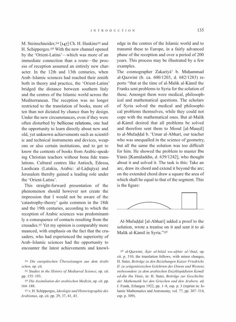
i n t r o d u c t i o n 135
M. Steinschneider,354 [147] Ch. H. Haskins355 and H. Schipperges.356 With the new channel opened by the ‘Orient-Latins’—which was more of an immediate connection than a route—the proc-ess of reception assumed an entirely new char-acter. In the 12th and 13th centuries, when Arab–Islamic sciences had reached their zenith both in theory and practice, the ‘Orient-Latins’ bridged the distance between southern Italy and the centres of the Islamic world across the Mediterranean. The reception was no longer restricted to the translation of books, more of-ten than not dictated by chance than by design. Under the new circumstances, even if they were often disturbed by bellicose relations, one had the opportunity to learn directly about new and old, yet unknown achievements such as scientif-ic and technical instruments and devices, weap-ons or also certain institutions, and to get to know the contents of books from Arabic-speak-ing Christian teachers without bona fide trans-lations. Cultural centres like Antioch, Edessa, Laodicæa (Latakia, Arabic: al-L®‰iq¬ya) and Jerusalem thereby gained a leading role under the ‘Orient-Latins’.
This straight-forward presentation of the phenomenon should however not create the impression that I would not be aware of the ‘catastrophy-theory’ quite common in the 18th and the 19th centuries, according to which the reception of Arabic sciences was predominant-ly a consequence of contacts resulting from the crusades.357 Yet my opinion is comparably more nuanced, with emphasis on the fact that the cru-saders, who had experienced the superiority of Arab–Islamic sciences had the opportunity to encounter the latest achievements and knowl-
354 Die europäischen Übersetzungen aus dem Arabi-schen, op. cit.
355 Studies in the History of Mediaeval Science, op. cit. pp. 155–193.
356 Die Assimilation der arabischen Medizin, op. cit. pp. 164–188.
357 v. H. Schipperges, Ideologie und Historiographie des Arabismus, op. cit. pp. 29, 37, 41, 43.
edge in the centres of the Islamic world and to transmit these to Europe, in a fairly advanced phase of the reception and over a period of 200 years. This process may be illustrated by a few examples.The cosmographer Zakar¬y®’ b. MuΩammad al-Qazw¬n¬ (b. ca. 600/1203, d. 682/1283) re-ports “that at the time of al-Malik al-K®mil the Franks sent problems to Syria for the solution of these. Amongst them were medical, philosoph-ical and mathematical questions. The scholars of Syria solved the medical and philosophi-cal problems themselves, while they could not cope with the mathematical ones. But al-Malik al-K®mil desired that all problems be solved and therefore sent them to Mosul [al-Mau◊il] to al-Mufa¥¥al b. ‘Umar al-Abhar¬, our teacher who was unequalled in the science of geometry, but all the same the solution was too difficult for him. He showed the problem to master Ibn Y‚nis [Kam®ladd¬n, d. 639/1242], who thought about it and solved it. The task is this: Take an arc, draw its chord and extend it beyond the arc; on the extended chord draw a square the area of which shall be equal to that of the segment. This is the figure:
Al-Mufa¥¥al [al-Abhar¬] added a proof to the solution, wrote a treatise on it and sent it to al-Malik al-K®mil in Syria.”358
358 al-Qazw¬n¬, §˚®r al-bil®d wa-a¿b®r al-‘ib®d, op. cit. p. 310; the translation follows, with minor changes, H. Suter, Beiträge zu den Beziehungen Kaiser Friedrichs II. zu zeitgenössischen Gelehrten des Ostens und Westens, insbesondere zu dem arabischen Enzyklopädisten Kemâl ed-din ibn Yûnis, in: H. Suter, Beiträge zur Geschichte der Mathematik bei den Griechen und den Arabern, ed. J. Frank, Erlangen 1922, pp. 1–8, esp. p. 3 (reprint in: Is-lamic Mathematics and Astronomy, vol. 77, pp. 307–314, esp. p. 309).

s c i e n c e a n d t e c h n o l o g y i n i s l a m136
[148] The spokesman of “the Franks” was Emperor Frederick II of Hohenstaufen (r. 1212–1250), the addressee the Aiyubid Sultan N®◊iradd¬n MuΩammad al-Malik al-K®mil (r. 615/1218–635/1238), who had ceded Jerusalem to Frederick by an agreement in the year 626/1292. Putting aside the question of how Frederick came to or from where he got such a difficult mathematical problem, let me first give another example:
Frederick II put seven questions from the field of natural sciences to al-Malik al-K®mil with the request to have them answered by his scholars. The Cairene juristprudent ∞ih®badd¬n AΩmad b. Idr¬s al-Qar®f¬ (d. 684/1285) preserved some of the questions together with other questions on natural sciences in a special treatise called Kit®b al-Istib◊®r f¬m® tudrikuhu l-ab◊®r359. Amongst the questions posed by Frederick II were, inter alia, the following:
“1. Why does one see oars, lances and all straight bodies of which a part is submerged in clear wa-ter, as bent towards the surface of the water?”“2. Why does one see Suhail (Canopus) larger
at its rising than at its highest position, although in the south there is no moisture—which, in the case of the Sun (viz. at the corresponding al-titudes) is used as an explanation (of this phe-nomenon)—because the southern areas are dry deserts?”360
359 v. E. Wiedemann, Optische Studien in Laienkreisen im 13. Jahrhundert in Ägypten, in: Eder. Jahrbuch der Pho-tographie (Leipzig) 27/1913/65–72 (reprint in: E. Wiede-mann, Gesammelte Schriften vol. 2, pp. 710–717 and in: Natural Sciences in Islam, vol. 34, pp. 153–160); idem, Fragen aus dem Gebiet der Naturwissenschaften, gestellt von Friedrich II., dem Hohenstaufen, in: Archiv für Kul-turgeschichte (Leipzig and Berlin) 11/1914/483–485 (re-print in: Wiedemann, Gesammelte Schriften, vol. 2, pp. 789–791 and in: Natural Sciences in Islam, vol. 34, pp. 173–175); Aydın M. Sayılı, Al Qar®f¬ and his explanation of the rainbow, in: Isis (Bruges) 32/1940–47/16–26 (re-print in: Natural Sciences in Islam, vol. 34, pp. 176–186).
360 Translated by E. Wiedemann, Fragen aus dem Ge-biet der Naturwissenschaften, op. cit. p. 484 (reprint in:
As a third example from the “Sicilian ques-tions” of Frederick II we may cite some that are of a philosophical nature. He addressed them to the Almohad sovereign ‘Abdalw®Ωid ar-Ra·¬d (r. 630/1232 to 640/1242). The philosopher and mystic ‘AbdalΩaqq b. Ibr®h¬m Ibn Sab‘¬n361 (b. 613/1216 or 614, d. 668/1270 or 669), at that time staying in Ceuta, was charged with the task of answering them. The first question put by the emperor runs thus: “Aristotle the sage teaches in all his writings the eternal existence of the world. Nobody doubts that this was his opinion. If Aristotle has proven that, what are the argu-ments that he used?”The second question: “What is the purpose of metaphysics? What are the required propaedeu-tics if any?”The third question: “What are categories? In which way do they serve as keys to the diverse areas of knowledge? What is their true number? Can they be increased or reduced? Which ap-proaches to reasoning and proof should be con-sidered in this regard?”The fourth question: “What is the proof for the immortality of the soul if it is indeed immor-tal? What is the position of the sage Aristotle on this question as opposed to Alexander of Aphrodisias?”
The fifth question refers to a quote from the Prophet MuΩammad.362
Gesammelte Schriften, op. cit. p. 790 and in: Natural Sci-ences, op. cit. p. 174).
361 C. Brockelmann, op. cit. vol. 1, p. 465, suppl. vol. 1, p. 844.
362 v. Martin Bravmann, Kaiser Friedrich II. und sein Verhältnis zur aristotelischen und arabischen Philoso-phie, in: M. Grabmann, Mittelalterliches Geistesleben. Abhandlungen zur Geschichte der Scholastik und Mystik, vol. 2, Munich 1936, pp. 103–137, esp. pp. 130–131 (re-print in: Islamic Philosophy, vol. 80, pp. 275–309, esp. pp. 302–303). Further studies concerning the philosophi-cal questions of Frederick II. in Islamic Philosophy, vol. 80 (Ibn Sab‘¬n and his philosophical correspondence with the Emperor Frederick II, Frankfurt 1999) are as follows: Michele Amari, Questions philosophiques adressées aux savants musulmans par l’empereur Frédéric II, in: Jour-

i n t r o d u c t i o n 137
[149] The questions on natural sciences, philos-ophy and even theology put to the Arab princes are not the only indication that the presence of the crusaders in an important part of the Islamic world had opened up an entirely new scenario for the process of becoming acquainted with local cultural assets and for their assimilation. This intellectually open atmosphere assumed a special quality with Emperor Frederick II and his personal inclinations and private encounters with sovereigns and scholars.
It is highly gratifying that in the past decade several commendable attempts have been made to investigate, in special events, the presence of the crusaders in Palestine from the viewpoint of history of science.363 Considerable progress was made away from the previously favoured view that the crusaders were not to be taken into con-sideration for the process of the reception of sci-
nal asiatique (Paris), 5ème série 1/1853/240–274; August Ferdinand Mehren, Correspondance du philosophe soufi Ibn Sab’în Abd oul-Haqq avec l’empereur Frédéric II de Hohenstaufen, publiée d’après le manuscrit de la Biblio-thèque Bodléienne, contentant l’analyse générale de cette correspondance et la traduction du quatrième traité sur l'immortalité de l’âme, in: Journal asiatique (Paris) 7ème série 14/1879/341–454; Ibn Sab‘în: Correspondance phi-losophique avec l’empereur Frédéric II de Hohenstaufen, vol. 1: Texte arabe publié par Serefettin Yaltkaya, Avant propos par Henry Corbin, Paris 1941 (Études Orientales vol. 8); Louis Massignon, Ibn Sab‘¬n et la critique psy-chologique dans l’historie de la philosophie musulmane, in: Mémorial Henri Basset. Nouvelles études nord-afri-caines et orientales, vol. 2, Paris 1928, pp. 123–130; Es-teban Lator, Ibn Sab‘¬n de Murcia y su “Budd al-‘®rif”, in: Al-Andalus (Madrid and Granada) 9/1944/ 371–417; Francesco Gabrieli, Fredrico II e la cultura musulmana, in: Rivista storica italiana (Naples) 64/1952/5–18; Darío Cabanelas, Frederico II de Sicilia e Ibn Sab‘in de Murcia. Las ‘Cuestiones sicilianas’, in: Miscelanea de estudios árabes y hebraicos (Granada) 4/1954/31–64.
363 e.g. Crusaders and Muslims in twelfth-century Syria, ed. Maya Shatzmiller, Leiden 1993; Occident et Proche-Orient: Contacts scientifiques au temps des Croisades. Actes du colloque de Louvain-la-Neuve, 24 et 25 mars 1997, ed. Isabelle Draelants, Anne Tihon, Baudouin van den Abeele, Louvain 2000.
ence and technology of the Arab–Islamic world; the contributions give rise to hopes that an ap-propriate correction in the historiography of sci-ences may be achieved in the near future. When Raymond Mercier364 in his substantial contribu-tion comes to the conclusion that from his point of view the crusaders have to be ruled out as mediators of knowledge in “mathematical as-tronomy”, then this is to be understood in the sense of translations of astronomical books. Yet undoubtedly many a crusader did come across one or the other of the astronomical instruments in widespread use during his stay in the Islamic world and brought such a device back to Europe on his return. Thus the ‘Orient-Latins’ will fre-quently have become middlemen for process-es regarding making and using of instruments, tools, weapons or drugs which they got to know, not by reading books but through personal con-tacts during their stay in Syria. The positive side-effects of the crusades in the field of astronomy include, for instance, the golden planetarium that Emperor Frederick II received in the year 629/1232 as a gift from al-Malik al-K®mil (or from M‚s® b. MuΩammad al-Malik al-A·raf, r. 626/1228–635/1237 in Damascus). “When [150] Frederick showed his precious planetari-um in which Sun, Moon and stars moved in cu-rious harmony, in later days to particularly dis-tinguished visitors, he loved to say that this gift from his Arab friend, the Sultan, was so dear to him, it came second in his love only to King Konrad, his son and heir.”365 Frederick kept the planetarium in Venosa.The supposedly French type of astrolabe with the lower equatorial bar (infra II, 101) and the mechanical Franco-Gothic lunar calendar (in-fra II, 170) are in my assessment also likely to
364 East and West contrasted in scientific astronomy, in: Occident et Proche-Orient, op. cit. pp. 325–342, esp. p. 340.
365 v. Ernst Kantorowicz, Kaiser Friedrich der Zweite, 3rd ed., Berlin 1931, vol. 1, p. 179, vol. 2, p. 69.
s c i e n c e a n d t e c h n o l o g y i n i s l a m138
have come to western Europe through channels opened up by the ‘Orient-Latins’. The investigation into instruments and tech-niques that have reached Europe from the Arabic area via the transmission lines of this category, must, in my view, be assigned the highest priori-ty in the future historiography of sciences. In my view gained through intensive occupation with the subject weapons in particular, improved or invented in the Arab–Islamic area, were adopted and used as quickly as possible by the crusad-ers and brought to Europe with minimal delay on the transmission routes in question. This in-cludes the winch crossbow, an improved variety of a weapon known already to the Greeks and the Romans. The decisive new element of this variant consisted in a winch which substantially facilitated the drawing of the large bow. There is historic evidence that such a crossbow was used against the crusaders in the year 647/1249 near al-Man◊‚ra in Egypt (infra V, 94). When in the year 636/1239 Emperor Frederick II ordered a captain sailing to Acco (‘Akk®) to purchase tres bonas balistas de torno et de duobus pedibus, in all likelihood this also referred to the same type of crossbow (infra V, 94).We should also mention the counter-balance trebuchet which appeared in the Arab–Islamic area in the early 13th century and soon after-wards was also used by the Europeans. It was a considerably more advanced type of catapult known already to the Greeks and the Sasanid Persians (infra V, 96).It is highly probable that the knowledge of fire-arms which reached Europe towards the end of the 13th or at the beginning of the 14th centu-ry came from the Arab–Islamic area as well. If it was not transmitted directly by the crusaders, then it came to Europe on a route via southern Italy (infra V, 101).
A certain type of mariners’ compass (infra III, 60) appears to have reached Europe on this route as well. It is described in an epistle, writ-ten in around 1270 by the French scholar Petrus Peregrinus, who got his sobriquet as a partici-
pant in one of the crusades. He also seems to have been present at the siege of Lucera in 1269. Frederick II had settled his Arab body guard from Sicily in this Apulian town in 1223.366 Even at a time when less was known about the process of the reception of Arabic sciences than today, it was considered whether the new infor-mation appearing in Peregrinus’ treatise might be connected with Arabic sources.367 [151] The subjects he dealt with, such as physical magnet-ism, the law of inertia, and other aspects from optics, astronomy and chemistry can now be traced back to Arabic sources without difficulty. This applies also to the two types of compass described by Peregrinus (infra III, 59 ff.). The more advanced compass of Arabic navigators in the Indian Ocean also seems to have reached Europe via southern Italy in the 15th century.368 The Genovese Christopher Columbus is known to have carried such a compass with him on his first voyage of discovery.369
The extant remains of illustrated Arabic man-uscripts and their Latin-Hebrew translations, on automata, mechanical devices, astrolabes, clocks, weapons and the like, allow us to conjec-ture that, at the time of the crusades—when the zest for reading was very strong in the Islamic world—such books drew the attention of the Orient-Latins and thus also found their way to Europe. For illustrated works to have exerted an influence, understanding the accompanying text was not always necessary. Regarding future research on the process of reception of Arab–
366 v. Erhard Schlund, Petrus Peregrinus von Maricourt, sein Leben und seine Schriften (ein Beitrag zur Roger Ba-con-Forschung), in: Archivum Franciscanum Historicum (Florence) 4/1911/436–455, 633–643, 5/1912/22–40, esp. pp. 450, 453, 455.
367 v. Erhard Schlund, Petrus Peregrinus, op. cit. p. 643; Eberhard Horst, Der Sultan von Lucera. Friedrich II. und der Islam, Freiburg etc. 1997, pp. 46–49.
368 v. F. Sezgin, op. cit. vol. 11, pp. 252, 325.369 ibid, vol. 11, p. 253; Heinz Balmer, Beiträge zur
Geschichte der Erkenntnis des Erdmagnetismus, Zurich 1956, p. 79 ff.

i n t r o d u c t i o n 139
Islamic sciences in the Christian-European cul-ture, a comparison of surviving works from both cultural areas under this aspect would appear promising to me. While occasionally consulting Latin and Italian illustrated works such as those by Conrad Kyeser (1405), Mariano Taccola (1433), Leonardo da Vinci (1519), Georgius Agricola (1556), Agostino Ramelli (1588) or Fausto Veranzio (1615), it occurred to me that they must have been strongly influenced by Arabic sources . The examples meant to give a certain idea of the second route of reception and assimilation of Arab–Islamic sciences via southern Italy shall conclude with the mention of three scholars whose works were the subject of recent research. They are Stephanus of Antioch (first half of the 12th c.), Leonardo of Pisa, known as Fibonacci (ca. 1170 – ca. 1240), and Theodorus of Antioch (d. 1250).
Stephanus of Antioch hailed from Pisa and went, possibly as a crusader, to Antioch where his uncle held the office of patriarch. He learned Arabic and took up the task of making a new translation of the handbook of medicine by ‘Al¬ b. al-‘Abb®s al-Ma™‚s¬ (4th/10th c.), which had been rendered incompletely by Constantinus Africanus and, what is more, circulated as the latter’s own work. It appears that Stephanus realised that the Liber pantegni was not by Constantinus Africanus only when he saw the Arabic original in Antioch (supra p. 91).370 In an-other book, called Liber Mamonis ,371 Stephanus appears as an assimilator of Arabic sciences. In this astronomical work he does not conceal the fact that he follows an Arabic precursor, al-
370 v. H. Schipperges, Die Assimilation der arabischen Medizin, op. cit. pp. 34–37; Ch. H. Talbot in: Dictionary of Scientific Biography, vol. 13, New York 1976, pp. 38–39; Ch. Burnett, Antioch as a link between Arabic and Latin culture in the twelfth and thirteenth centuries, in: Occi-dent and Proche-Orient, op. cit. pp. 1–78, esp. p. 6 ff.
371 Ch. H. Haskins, Studies in the History of Mediaeval Science, op. cit. pp. 98–103; Ch. Burnett, Antioch as a link between Arabic and Latin culture, op. cit. p. 13.
though he does not give his name. It is remark-able that numbers are expressed in Arabic nu-merals.372
[152] While in Christian scholarly circles of the 12th century rather the study of Greek and Hebrew—for the sake of biblical studies—was encouraged, Stephanus speaks of arabica ver-itas in which one finds nourishment for the body as well as for the soul.373
Leonardo of Pisa (Fibonacci),374 together with Theodorus of Antioch, belonged to the circle of scholars around Emperor Frederick II and is considered to be “the first great mathematician of the Christian West”. His father being the head of the merchant colony of Pisa in Bugia (Bi™®ya in today’s Algeria) from 1192, he had the op-portunity to come into contact with Arab schol-ars and to travel, in the company of his father and also on his own, to Egypt, Syria, Greece, Sicily and southern France. After his return to Pisa, he composed five works on arithmetic, al-gebra and geometry. Although his books are not the first ones written on these subjects in the Latin language, yet they stand out with clarity and versatility, and their special importance lies in their author’s treatment of linear and quadrat-ic equations with a comprehension and lucidity unknown in Europe up to his times. There is no doubt that his sources were translations of Arabic works, and it is also not ruled out that Leonardo, during his stay in Algeria and his visit to other Arabic countries, also came across mathemati-cal works in the Arabic original and later took them to Pisa. His position in the history of the reception and assimilation of Arabic mathemat-ics should be seen in the fact that he acquaint-
372 v. R. Lemay, De la scolastique à l’histoire par le tru-chement de la philologie: itinéraire d’un médiéviste entre Europe et Islam, in: La diffusione delle scienze islamiche nel medio evo europeo. Convegno internazionale dell’Ac-cademia Nazionale dei Lincei, Rome 1987, pp. 399–535, esp. pp. 471–472; Ch. Burnett, op. cit., p. 13.
373 Ch. Burnett, op. cit. pp. 18–19.374 v. Kurt Vogel in: Dictionary of Scientific Biography,
vol. 4, New York 1971, pp. 604–613.

s c i e n c e a n d t e c h n o l o g y i n i s l a m140
ed the Latin reader with the topics and contents of his Arabic sources in surprisingly success-ful compositions, not without adding some les-sons of his own. In doing so he certainly did not cover all the important problems and results of Arab–Islamic mathematics that were available to him. The particular merit of his presentation lies in the treatment of arithmetic and algebra on the basis of the decimal place value system.
Fibonacci was apparently the first mathemati-cian in the West to express the concept of zero with the term cephirum, borrowed from Arabic ◊ifr (which eventually became zero in Italian).375 In 1202 the fraction stroke to separate the nu-merator from the denominator appears in his writings, from which we can assume that he was familiar with the use of this notation amongst west-Arabic mathematicians, as for instance in Ab‚ Zakar¬y®’ MuΩammad b. ‘Abdall®h b. ‘Aiy®· al-ºa◊◊®r376 (6th/12th c.).377
Leonardo’s much higher mathematical stand-ard compared with his European contemporar-ies can probably be explained with the fact that, on the one hand, during his relatively long stay in Arab countries he was in the position to ac-quaint himself with Arabic sources that had not yet reached Europe and that, on the other hand, he had the opportunity to sharpen his insight in the matter in lectures and discussions during his contacts with Arab–Islamic mathematicians. Raymond Mercier378 described Leonardo’s ex-ceptional situation from his point of view [153] in the following words: “The Latin world of the 12th century was not so privileged. Here
375 v. A.P. Juschkewitsch, Geschichte der Mathematik im Mittelalter, op. cit. p. 351.
376 v. H. Suter, Die Mathematiker und Astronomen der Araber und ihre Werke, Leipzig 1900, pp. 197–198.
377 H. Suter, Das Rechenbuch des Abû Zakarîjâ el-ºa◊◊âr, in: Bibliotheca Mathematica (Leipzig) 3rd series, 2/1901/12–40, esp. p. 19 (reprint in: Islamic Mathematics and Astronomy, vol. 77, pp. 332–360, esp. p. 339); A.P. Juschkewitsch, op. cit. p. 366.
378 East and West contrasted in scientific astronomy, op. cit. p. 236.
the transmission was almost entirely through books, even when the Latin translations were made in Toledo, or elsewhere in Andalus. There must have been very little contact with the liv-ing mathematical practitioners in the Arabic or Hebrew speaking world. An exception appears to be provided by the 13th century mathema-tician Leonardo of Pisa (Fibonacci), who as we understand, had direct access to the math-ematical community in Islamic North Africa, at Bij®ya (modern Algeria). The brilliant crea-tive work which he produced shows well what could be achieved in the Latin world when liv-ing teachers were involved. The history of Latin science from the 12th to the early 16th centuries is largely one of a struggle to transcend book learning. Only at the end of that long period do we observe Europeans as true masters of scien-tific subjects.”
As the third of the scholars contributing to the reception of Arab–Islamic sciences on the route via Sicily and Italy, we shall mention Theodorus of Antioch. Unlike the two aforesaid scholars he was not from Pisa, but was a Christian Arab who had been in the service of Frederick II in Sicily as a scholar and advisor for some time. The Syrian-Christian scholar Abu l-Fara™ Ibn al-‘Ibr¬ (Bar Hebræus, d. 1286ce) gives an interest-ing biographical account which draws a vivid picture of the life and work in a community of scholars of different creeds and shows that this essential characteristic of intellectual culture in the Islamic world continued to exist even under the rule of the crusaders. Bar Hebræus’ narra-tive379 reads in translation:380 “˘®‰ur¬ of Antioch
379 Ta’r¬¿ mu¿ta◊ar ad-duwal, ed. —®lΩ®n¬, Beirut 1890, pp. 477–478.
380 Rendered, with minor changes, from the German version by H. Suter, Beiträge zu den Beziehungen Kai-ser Friedrichs II. zu zeitgenössischen Gelehrten, op. cit. p. 8 (reprint op. cit. p. 314); English: Ch. Burnett, Master Theodore, Frederick II’s philosoper, in: Federico II e le nuove culture. Atti del XXXI Convegno storico interna-zionale, Todi, 9–12 ottobre 1994, Spoleto 1995, pp. 225–285, esp. pp. 228–229.

i n t r o d u c t i o n 141
[al-Anfl®k¬], a Jacobian Christian accomplished himself in the Syrian and Latin language and in the sciences of Antiquity while in Antioch, then he travelled to Mosul [al-Mau◊il] and studied un-der Kam®ladd¬n b. Y‚nis the works of al-F®r®b¬, Ibn S¬n®, Euclid and the Almagest. Then he re-turned to Antioch, but did not stay there long because it had become clear to him that here he could not further advance his knowledge and so went to Kam®ladd¬n b. Y‚nis at Mosul for a sec-ond time and deepened his knowledge. Then he went to Baghdad, perfected himself in the science of medicine, studied its achievements and mas-tered its special applications. He wanted to en-ter the services of Sultan ‘Al®’add¬n (Kayqub®d, r. 618/1220–634/1237), but the Sultan did not show any inclination. Then he went to Armenia and entered the services of Constantine, the son of King º®tim (Heflum I),381 but he found their society (their attitudes) not agreeable and therefore he travelled with an emissary of the Imb®r‚r (Emperor), the king of the Franks to the same, from whom he received kindnesses and in whose favours he was. He even invested him with a complete city and its surroundings…”
This versatile scholar with his well-founded knowledge of Arabic sciences seems to have assumed a prominent position in scientific life, shortly after his admission to the court of Frederick II. It seems [154] justified to assume that he contributed substantially to the math-ematical, scientific and philosophical queries sent by the Emperor to al-Malik al-K®mil or Ibn Sab‘¬n (supra p. 147 ff.). In this regard it is also remarkable that Leonardo of Pisa correspond-ed with Theodorus on mathematical matters. Leonardo wrote him a letter which contained problems leading to indeterminate equations of the first degree. “Theodorus, in turn, sent Leonardo a problem from indeterminate anal-ysis of the second degree which Leonardus
381 v. Ch. Burnett, Master Theodore, op. cit. p. 232.
solved in his Liber quadratorum”.382 No doubt Theodorus had an important part in the introduc-tion and dissemination of Arabic works in Sicily and southern Italy. We know that he translated for the Emperor a book on falconry into Latin which is extant under the title Moamin383 and largely has the character of a veterinary book. The Arabic original was probably related to the falconry book384 which was translated into Spanish on commission by Alfonso X about a quarter of a century later. It is not surprising that the Emperor himself composed his own el-egant book on the basis of the former and other sources, his own experiences and in collabora-tion with Arabic falconers whom he had drawn to his court—to use his own words—“at great expenses”. It was entitled De arte venandi cum avibus (“On the Art of Hunting with Birds”).385
3. the route of reception via byzantium
This route of reception of Arab–Islamic sci-ences led from the centre and the eastern parts of the Islamic world to Byzantium and from there to Europe. Hermann Usener386 al-ready became aware of manuscripts containing
382 H. Suter, Beiträge zu den Beziehungen Kaiser Frie-drichs II., op. cit. p. 8 (reprint, op. cit. p. 314).
383 Die Falkenheilkunde des “Moamin” im Spiegel ih-rer volgarizzamenti. Vol. 1: Edition der neapolitanischen und der toskanischen Version mit philologischem Kom-mentar von Martin-Dietrich Glessgen, Tübingen 1996 (Zeitschrift für romanische Philologie, Beiheft 269); cf. Ch. Burnett, op. cit. p. 239.
384 Written by MuΩammad b. ‘Abdall®h b. ‘Umar Ibn al-B®zy®r (3rd/9th c., see F. Sezgin, op. cit. vol. 6, p. 193, vol. 7, pp. 154, 329), Spanish translation Libro de los ani-males que cazan, ed. J. M. Fradejas Rueda, Madrid 1987; v. Ch. Burnett, op. cit. p. 240.
385 Published in various editions and facsimiles; earliest edition by Carl Arnold Willemsen, Friderici Romanorum Imperatoris Secundi De arte venandi cum avibus, 2 vols., Leipzig 1942; facsimile edition Graz 1969, with a com-mentary volume by C.A. Willemsen, Kaiser Friedrich der Zweite, Über die Kunst mit Vögeln zu jagen, Frank-furt 1970.
386 Ad historiam astronomiæ symbola, Bonn 1876.

s c i e n c e a n d t e c h n o l o g y i n i s l a m142
Byzantine translations of Arabic–Persian books in European libraries a hundred and thirty years ago.387 Subsequent research also occasionally drew attention to translations of Arabic books into Byzantine Greek as, for example, Symeon Seth’s388 translation of the collection of fa-bles Kal¬la wa-Dimna (end of the 11th c. CE) from the Arabic version that ‘Abdall®h Ibn al-Muqaffa‘ (d. 139/756) had compiled from the Middle Persian version, or the anonymous trans-lation of the book on medicine, Z®d al-mus®fir of AΩmad b. Ibr®h¬m Ibn al-©azz®r 389 (d. 369/979), whose translator betrays the knowledge of fur-ther Arabic sources.390
[155] After a rather long interruption the ques-tion of the knowledge of Arab–Islamic sciences in Byzantium once again attracted the attention of historians of science, especially after Otto Neugebauer had discovered the drawing of a model of the Sun with a double epicycle in the Greek translation of an astronomical book in a Vatican manuscript.391 While it had been es-tablished for several years that Copernicus was influenced by Arab–Islamic astronomers in his attempt to restore the principle of the uniform motion of the planets violated by Ptolemy’s
387 v. F. Sezgin, op. cit. vol. 6, p. 57.388 v. Karl Krumbacher, Geschichte der byzantinischen
Litteratur von Justinian bis zum Ende des Oströmischen Reiches (527–1453), 2nd ed. Munich 1897 (reprint: New York 1970), p. 896; G. Sarton, Introduction… op. cit. vol. 1, p. 771.
389 v. F. Sezgin, op. cit. vol. 3, pp. 304–307.390 v. Charles Daremberg, Recherches sur un ouvrage
qui a pour titre Zad el-Mouçafir, en arabe, Éphodes, en grec, Viatique, en latin, et qui est attribué, dans les tex-tes arabes et grecs, à Abou Djafar, et, dans le texte la-tin, à Constantin, in: Archives des missions scientifiques et littéraires, choix de rapports et instructions (Paris) 2/1851/490–527, esp. p. 505 (reprint in: Islamic Medicine, vol. 39, pp. 1-38, esp. p. 16).
391 v. E.S. Kennedy, Planetary theory in the medieval Near East and its transmission to Europe, in: Oriente e Occidente in medioevo: filosofia e scienze. Convegno in-ternazionale, [Roma] 9–15 aprile 1969, Rome 1971, pp. 595–604, esp. 602.
Almagest,392 this new find provided a lead in the issue of how that influence was transmitted. After the preliminary work by O. Neugebauer393 and E.S. Kennedy,394 subsequent scholars took the view that the relevant Arabic and in partic-ular also Persian books on the latest planetary theories of Islamic astronomy found their way to Europe via Byzantine versions. Since then sev-eral studies and text editions by David Pingree (Brown University), Joseph Mogenet and his successor Anne Tihon (both Louvain) have con-siderably expanded our knowledge about the reception of Arabic astronomy and astrology amongst the Byzantines.
In an attempt to sum up the results achieved up to 1976, Mogenet395 asks himself regarding the attitude of the Byzantines towards Arab as-tronomy between the 9th and the 14th century, to what extent one might speak generally of ac-ceptance or of resistance. With his colleagues from Louvain, he was inclined to see two dis-tinct periods in the Byzantine attitude, the first lasting from the 9th to the 13th centuries and the second from the 13th to the 14th centuries. He argues that in the second phase a kind of ren-aissance in the field of science came about in which contact with Arab–Islamic sciences was decisive.396 Yet the influence of Islamic sciences was felt also in the first phase which Mogenet calls “traditionalist” and in which astronomy had enjoyed less prominence than astrology.397 His successor, Anne Tihon, while characteris-
392 v. F. Sezgin, op. cit. vol. 6, p. 55.393 Studies in Byzantine astronomical terminology, Phil-
adelphia 1960 (Transactions of the American Philosophi-cal Society, vol. 50, part 2).
394 Late medieval planetary theory, in: Isis (Baltimore) 57/1966/365–378.
395 L’influence de l’astronomie arabe à Byzance du IXe au XIVe siècle, in: Colloques d’histoires des sciences I (1972) et II (1973). Université de Louvain, Recueil de tra-vaux d’histoire et de philologie, série 6, 9/ 1976/45–55, esp. p. 45.
396 ibid, p. 46.397 ibid, pp. 48 ff.

i n t r o d u c t i o n 143
ing the astronomical–astrological pursuit in this first phase, comes to a somewhat more nuanced view by distinguishing two currents. The first of these currents was on a fairly elementary level. The second was characterised by the introduc-tion of Islamic astronomical tables.398
The earliest evidence that we know so far for an acquaintance of the Byzantines with Arab as-tronomy are comments on the Almagest dated 1032.399 Their anonymous author undertakes a critical comparison between Ptolemaic as-tronomy and that of the “moderns” (neåteroi), meaning the Arab astronomers.400 [156] He uses the tables of one ∫Alìm who is today identified as Abu l-Q®sim ‘Al¬ b. al-A‘lam al-Ba∫d®d¬401 (d.375/985).402
The second oldest testimony dates from around 1072. It is an anonymous Greek com-pilation from the Z¬™ by ºaba· al-º®sib403 (d. end of 3rd/9th c.), the commentary by AΩmad b. al-Mu˚ann®404 (5th/11th c.) on the Z¬™ of MuΩammad b. M‚s® al-øw®rizm¬405 (1st quarter of the 3rd/9th c.) and from an Arabic astrologi-cal book.406 The most significant feature of this
398 Les textes astronomiques arabes importés à Byzance aux XIe et XIIe siècles, in: Occident et Proche – Orient: Contacts scientifiques au temps des Croisades, op. cit. pp. 313-324, esp. p. 316.
399 J. Mogenet, Une scolie inédite du Vat. gr. 1594 sur les rapports entre l’astronomie arabe et Byzance, in: Osi-ris (Brügge) 14/1962/198–221.
400 Anne Tihon, L’astronomie byzantine (du Ve au XVe siècle), in: Byzantion (Brussels) 51/1981/603–624, esp. p. 611.
401 v. F. Sezgin, op. cit. vol. 6, pp. 215-216; Raymond Mercier, The parameters of the Z¬j of Ibn al-A‘lam, in: Archives internationales d’histoire des sciences (Rome) 39/1989/22-50.
402 Anne Tihon, Sur l’identité de l’astronome Alim, in: Archives internationales d’histoire des sciences (Rome) 39/1989/3-21.
403 v. F. Sezgin, op. cit. vol. 6, pp. 173-175.404 ibid, p. 142.405 ibid pp. 140-143.406 v. Otto Neugebauer, Commentary on the astro-
nomical treatise Par. gr. 2425, Brussels 1969; Alexander Jones, An eleventh century manual of Arabo-Byzantine
manuscript seems to be that the sine and versed sine functions occur here for the first time in a Greek text (going back to the Z¬™ of ºaba·).407
A more recent compilation which is quite illu-minating for our topic dates from the end of the 12th century and is found in the Codex Vat. gr. 1056.408 In this compilation of predominantly astrological content the names of roughly twen-ty Arab, Indian and pseudo-Indian authors are mentioned.409 Explicitly cited are al-øw®rizm¬, ºaba· al-º®sib, K‚·y®r b. Labb®n and the ®kim-ite* tables by ‘Al¬ b. ‘AbdarraΩm®n Ibn Y‚nis. While studying the star tables in this compila-tion, Paul Kunitzsch410 found “indisputable evi-dence of Arabic-Islamic origin”. With regard to the stellar nomenclature he noticed411 that “al-though they were all designated with Greek ex-pressions,” these were “frequently not the actual Greek, i.e. Ptolemaic names but literal transla-tions of Arabic ones.”
The compilation also contains the translation of an Arabic treatise on the astrolabe in which several Arabic technical terms were left untrans-lated and rendered in Greek transliteration (as kótp = quflb).412
In this connection we should also mention the only known “Byzantine” astrolabe.413 According
astronomy, Amsterdam 1987; J. Mogenet, L’influence de l’astronomie arabe à Byzance, op. cit. pp. 49-50; Anne Tihon, Les textes astronomiques arabes importés a Byzance, op. cit. pp. 316, 318.
407 Anne Tihon, op. cit. p. 318.408 Catalogus codicum astrologorum graecorum, vol. 5,
part 3, Brussels 1904, pp. 7-64.409 v. Anne Tihon, L’astronomie byzantine, op. cit. p.
612; idem, Tables islamiques à Byzance, in: Byzantion (Brussels) 60/1990/401-425, esp. pp. 405-413.
410 Die arabische Herkunft von zwei Sternverzeichnissen in cod. Vat. gr. 1056, in: Zeitschrift der Deutschen Mor-genländischen Gesellschaft (Wiesbaden) 120/1970/281-287, esp. p. 282.
411 ibid, p. 282.412 v. Anne Tihon, Tables islamiques à Byzance, op. cit.
p. 406.413 v. O. M. Dalton, The Byzantine astrolabe at Brescia,
in: Proceedings of the British Academy, vol. 12, London

s c i e n c e a n d t e c h n o l o g y i n i s l a m144
to an inscription engraved on the back, the in-strument, preserved in the Museo dell'Età Cristiana in Brescia, is supposed to have been made for a consul of Persian origin by the name of Sergios. It can be considered as certain that the Byzantines used the astrolabe for the obser-vation of celestial constellations in the 11th cen-tury, but because of certain features we should be reluctant in calling this instrument [157]
“Byzantine”. Firstly, the fixed star lura (Vega) is represented in the Arabic manner in the form of a bird (an-nasr al-w®qi‘ = the descending ea-gle), which was known in the West from the 10th century.414 Secondly, the latitude of Byzantium (= Constantinople) being indicated as 41° on the disc casts suspicion on the date of the astro-labe. That is because the latitude of Byzantium was registered at 43° in the Ptolemaic geogra-phy and 45° with the early Arabic geographers and corrected to 41° only towards the end of the 13th century (the modern value is 41°02’). Thirdly, on the back of the mater a quadruple tangent quadrant is engraved which overlaps the scale on the rim, thus creating the impression that it was added by a later hand, especially in view of the fact that the tangent function, known since ºaba· (3rd/9th c.), begins to appear in the tangent quadrants on the back of astrolabes only from the first half of the 11th century. That the names of the fixed stars correspond to those of the Almagest rather than Arabic does not provide a clue to the age of the astrolabe. The Byzantines
1926, pp. 133-146, 3 pictures; R. Gunther, The Astrolabes of the World, op. cit. pp. 104-108; Burkhard Stautz, Die früheste bekannte Formgebung der Astrolabien, in: Ad radices. Festband zum fünfzigjährigen Bestehen des In-stituts für Geschichte der Naturwissenschaften der Johann Wolfgang Goethe-Universität Frankfurt am Main, ed. Anton von Gotstedter, Stuttgart 1994, pp. 315-328, esp. pp. 319-320; idem, Die Astrolabiensammlung des Deut-schen Museums und des Bayrischen Nationalmuseums, München 1999, p. 11; A. Tihon, Les textes astronomiques arabes, op. cit. p. 323
414 Paul Kunitzsch and Tim Smart, Short guide to mod-ern star names and their derivations, Wiesbaden 1986, pp. 43-44.
has been familiar with the Almagest and its con-tent for a long time. However, the precession value of 1 for 66 years on which the positions of the fourteen stars on the rete are based is Arab-Islamic, not Greek. On the whole the astrolabe is Arab-Islamic in its style and its individual ele-ments, only the language of the engraved names and other inscriptions is “Byzantine”. Thus it re-flects the heterogeneous and anachronistic char-acter of the contemporary Byzantine astronomi-cal writings.
After a fairly successful introduction of Arabic language-based astronomy in Byzantium in the course of the 11th and the 12th centuries, the Latin crusade kingdom in Constantinople (1204-1261) not only interrupted any further develop-ment, but it also obliterated the body of writings already accomplished at that time.415 Yet it did not take long until around the turn of the 13th to the 14th century new interest in Arabic-Persian science manifested itself. This time the route to Constantinople came from the east.Immediately after the conquest of Baghdad in the year 656/1258, Hülegü, the grandson of Cengiz ø®n, settled in the city of Maragha, roughly 30 km to the south-east of Lake Urmia, and had a grand observatory built under the direction of the polymath Na◊¬radd¬n afl-fi‚s¬ which was fur-nished with special observation structures (infra II, 28 ff). At the time of the Mongols, Maragha had a significant Christian population seg-ment and maintained busy traffic with the city of Trebizond (Trabzon) on the Black Sea (still under Byzantine rule) and with Constantinople via Trebizond. The interchange with these cit-ies increased when Abaqa ø®n, the successor of Hülegü, made Tabr¬z his capital in the year 663/1265. Tabr¬z developed into an important centre of sciences when the universal scholar Ra·¬dadd¬n Fa¥lall®h afl-fiab¬b (d.718/1318, su-pra, pp. 58, 61) was grand vizier there under the Ilkh®ns π®z®n (694/1295-703/1304) and
415 . v. A. Tihon, Les textes astronomique arabes, op. cit. p. 324.
i n t r o d u c t i o n 145
Öl™eitü (703/1304-716/1316). Ra·¬dadd¬n, one of the foremost figures in cultural history, not only became a legend of his times, but personal-ly contributed much in making Tabr¬z a metrop-olis and a centre of trade and sciences in which scholars from the East and West were to find a home and representatives of diverse cultures a meeting place. His surviving works convey a vivid [158] picture of the cultural and scientific life in the city.
About the quarter of the city called Rab‘-i Ra·¬d¬ or ∞ahrist®n-i Ra·¬d¬ that Ra·¬dadd¬n himself had built, the deed of foundation, which recent research has made known, provides de-tailed information. The Austrian Orientalist Karl Jahn416 who, from the 1940s, devoted him-self entirely to research into the life and work of Ra·¬dadd¬n, reports on this document, inter alia:
“Thus it follows from this document that the maintenance of the Rab‘-i Ra·¬d¬ was secured through the income of various pious founda-tions which Ra·¬d al-D¬n had established in Iran and also in Anatolia. But of particular interest is the information about the organisation of the Ra·¬d quarter. According to it, there lived and worked for payment under the supervision of the endowment administration, a large number of artists and artisans, who belonged to all kind of nations, lived and worked for remuneration under the supervision of the foundation coun-cil. Aside from a large number of Turks, most of them were either Greek, Georgian, Armenian, Indian, Russian, African and some belonged to still other nations…” The teaching and research institutions had “6000-7000 students from all parts of the Ilkhanid empire studying at public expense, and more than 400 scholars who lived in their own quarters and were in the position to
416 Täbris, ein mittelalterliches Kulturzentrum zwischen Ost und West, in: Anzeiger der Österreichischen Akade-mie der Wissenschaften, Philologisch-historische Klasse 105, Nr. 16, Vienna 1968, pp. 201-211, esp. pp. 208-209.
devote themselves to teaching and research un-burdened by the troubles of everyday life.”417
Further references to the important role of the city of Tabr¬z in trade and sciences contributed to by Ra·¬dadd¬n are found in his correspond-ence418 with important people of the Islamic and non-Islamic world. We learn from it that in the Rab‘-i Ra·¬d¬ he had designated quarters for the various ethnic groups and that he had charged his son ©al®ladd¬n, who was governor of a re-gion in Asia Minor, with persuading fourty or so Greek families to settle in the district destined for the Byzantines. One discovers further that Constantinople and Venice used to pay tributes to the Ilkh®ns which Ra·¬dadd¬n used for the ali-mentation of the students.419
A further testimony to the importance of Tabr¬z at that time was discovered by Z. V. Togan in the middle of the previous century in the sci-entific “Questions and Answers” (al-As’ila wa-l-a™wiba) from the correspondence of Ra·¬dadd¬n. These shed light the close contacts— to an ex-tent which had not hitherto been known— in the field of science between Byzantium and the em-pire of the Ilkh®ns. Thus a Byzantine philoso-pher and physician in the service of Ra·¬dadd¬n translated his answers to questions of the Basileus (probably Andronikos II Palaiologos, r. 1282-1328) from the Persian into Greek. He also took pains to give the emperor an idea of Ra·¬dadd¬n’s extraordinary rank in the scienc-es by stating that “Plato, Aristotle and the other great [Greek] philosophers, if they lived today,
417 ibid, p. 211.418 Muk®tab®t-i Ra·¬d¬, ed. M. ∞af¬‘, Lahore 1947, p. 63,
cf. Z. V. Togan, Ilhanlılarla Bizans arasındaki kültür mü-nasebetlerine ait bir vesika (A document concerning cul-tural relations between the Ilkhanide and Byzantiens), in: Islâm Tetkikleri Enstitüsü Dergisi (Istanbul) supplement to vol. 3 (1966), p. 1*-39*, esp. p. 2*.
419 Muk®tab®t-i Ra·¬d¬, op. cit. p. 319; Z. V. Togan, op. cit., p. 2*.
s c i e n c e a n d t e c h n o l o g y i n i s l a m146
would be proud to be counted amongst his dis-ciples.”420
[159]The “Questions and Answers”, preserved in an Arabic and a Persian version, are predomi-nantly of philosophical, theological and medical content. The Persian redaction was published in facsimile in 1966 with a brief study by Z. V. Togan. No in-depth study of the correspondence is known to me.
Since the attempt by H. Usener (supra p. 154), recent research in the history of Byzantine sci-ences has concentrated mostly on the fields of astronomy and astrology. The studies from the second half of the 20th century have informed us, above all, about the vogue of translations of astronomical works from the Persian that oc-curred in the first half of the 14th century. Many of the translated works have meanwhile been edited or examined.421
In 1947, George Sarton called the transla-tion movement from the Persian to the Greek
“Persian renaissance”, which could also be called “Arabic [renaissance].”422 Karl Krumbacher423 saw in it “one of the most remarkable examples of literary retro-movement”, and concluded that only through Arabic-Persian mediation had the Greeks come to know the wisdom of their own ancestors. Joseph Mogenet424 speaks of a kind of renaissance in the field of science during the
420 Ra·¬dadd¬n, al-As’ila wa-l-a™wiba, MS Istanbul, Ayasofya 2180, 264b-265a; Z. V. Togan, Ilhanlılarla Bi-zans arasındaki kültür münasebetlerine ait bir vesika, op. cit. p. 5.
421 v. F. Sezgin, op. cit. vol. 6, pp. 56-57; Anne Tihon, Les tables astronomiques persanes à Constantinople dans la première moitié du XIV siècle, in: Byzantion (Brussels) 57/1987/471-487, 4 illustrations; idem, Tables islamiques à Byzance, in: Byzantion (Brussels) 60/1990/401-425; idem, Traités byzantins sur l’astrolabe, in: Physis (Flor-ence) 32/1995/323-357.
422 G. Sarton, Introduction … op. cit. vol. 3, part 1, p. 63.
423 Geschichte der byzantinischen Litteratur, op. cit. vol. 1, p. 622.
424 L’influence de l’astronomie arabe à Byzance du IXe au XIVe siècle, op. cit. p. 54.
13th and the 14th centuries in which the contacts with the Arabic-Persian sciences were of great importance.
The hitherto known astronomical works of the Byzantines,–whose authors built upon the works translated from the Persian with their ta-bles, descriptions of astrolabes etc.–actually re-flect more than merely a literary revival move-ment as held by Krumbacher. However, it is conspicuous that none of the works mentioned, with the exception of the anonymous manuscript discovered by Neugebauer in the Vatican, refers to the new non-Ptolemaic planetary models dis-cussed by Persian and Arabic astronomers in the second half of the 13th century and later. It has long since been proved (supra p. 53 ff) that some of these new planetary theories reached eastern Europe in the first half of the 15th cen-tury425 at the latest and came to be known to Copernicus. The verdict426 that the Byzantine side showed a lack of criticism and of deeper understanding of Arabic-Islamic astronomy and these shortcomings my be the true reason why Arabic astronomy never established itself firmly amongst the Byzantines. What is more, quite a few Byzantines obstinately held fast to the res-toration of Ptolemaic astronomy.427
The importance of this third route of reception of Arabic-Islamic sciences was by no means limited to the translation of Persian works into Greek. Personal contacts between Italy, Middle and Eastern Europe and Persia increased the po-tency of the reception and made it possible for the latest achievements of the eastern Islamic world to reach the West without much delay. Thus, for instance, the advanced rainbow theory of Kam®ladd¬n al-F®ris¬ came [160] very proba-bly on this route to the knowledge of Dietrich of Freiberg (infra III, 169 ff) around the first decade
425 v. F. Sezgin, op. cit. vol. 6, p. 56.426 Anne Tihon, Un traité astronomique chypriote
du XIVe siècle, in: Janus (Leiden) 64/1977/279-308, 66/1979/49-81, 68/1981/65-127, esp. p. 109.
427 ibid, p. 109.
i n t r o d u c t i o n 147
of the 14th century. We can also imagine that the Kit®b a·-∞akl al-qaflfl®‘ by Na◊¬radd¬n afl-fi‚s¬ (d. 672/1274) in which he established trigonome-try as an independent discipline reached Europe on this route where it gave rise to the De tri-angulis omnimodis of Johannes Regiomontanus (1436-1476) (infra III,135 ff.). Na◊¬radd¬n afl-fi‚s¬ spent the last sixteen years of his life in Maragha, where he led the newly founded ob-servatory, and both Maragha and Tabr¬z were still frequently visited by Byzantine and other Christian travellers to Asia in the 14th century. In this connection it is illuminating that an orig-inal celestial globe from the Maragha observa-tory was brought to Europe quite early and was kept in Dresden from 1562 (infra II, 52). With our assumption that Na◊¬radd¬n’s trigonometry book reached the West via Byzantium we do not necessarily mean to imply that it was already translated there. From when Constantinople was threatened and ultimately conquered by the Ottomans, new paths opened up with branch-es leading to Rome, northern Italy, eastern and central Europe. Books in the original and in translations as well as instruments and maps were transported along these routes, but most notably a spirit of hostility against Islam on the one hand and the idea of reinstatement of the hegemony of the old Greek sciences on the oth-er. The most notorious character amongst these zealots was Cardinal Bessarion, the former pa-triarch of Constantinople. During his travels across Europe he also met G. Peuerbach and J. Regiomontanus in Vienna and instigated the latter to revise Ptolemy’s Almagest. The fac that this revision predominantly conveys the achievements of Arab astronomers shows us that Bessarion tried in vain to turn back the wheel of the history of science.428
428 v. F. Sezgin, op. cit., vol. 6, p. 58.
conclusion
At first a short introduction was envisaged in or-der to give the user of the present Catalogue an overall idea, based on the current research, of the position of Arabic-Islamic sciences in the universal history of sciences. While attempting this, I was conscious that such an undertaking is connected with all sorts of pitfalls. On the one hand, the research on the subject, despite a rela-tively long development, is still at such an early stage that one could believe to be able to make a relatively adequate presentation on the basis of the results achieved so far that are within one’s grasp. On the other hand, what has been achie-ved by research until now is so voluminous that with a first attempt one runs the risk of being able to grasp and transmit only a part. Added to this there are the difficulties connected with the selection of the topics and the problems to be included. Moreover, two conflicting feelings accompanied me from the beginning of the at-tempt. One of them states that the insights gai-ned so far cannot be dealt with in the scope of a brief introduction, the second consists of the fear that through a more detailed treatment of this theme the further revision of the volumes on geography and literature of my Geschichte des arabischen Schrifttums prepared approxi-mately fifteen years ago and ready in rough copy would suffer another delay. Therefore I gave up a detailed discussion of the process of assimila-tion of Arabic-Islamic sciences in the Occident beyond the 13th century which would have allo-wed me an exhaustive comparison between the two cultures in respect of their basic procedu-res or basic values of scientific endeavours like the art of experimenting, continuous practical observation for long periods in astronomy [161], the importance of criticism, the custom of na-ming sources precisely, the acknowledgement of the achievements made by predecessors, the concept of the law of evolution and other topics. These aspects are to be dealt with in the third

s c i e n c e a n d t e c h n o l o g y i n i s l a m148
section that follows, wherein the question is posed about the end of creativity in Islam.
Through the conquest of a substantial part of the region of the Mediterranean and of Persia in the first half of the first century of Islam (7th c. AD), the Muslims were able to bring most of the important cultural centres under their rule. One cannot rate highly enough the great coincidence, which is significant from the viewpoint of hi-story of science, that the carriers of culture of those times, whether Christians, Jews, Sabaeans or Zoroastrians, and regardless of whether they were converted or not, could live together with the conquerors and continue their scientific work, and were even encouraged by their new rulers in such work. Largely on the basis of this harmonious co-existence of people belonging to different cultures and religions, there arose in the Islamic world a teacher-pupil-relationship the like of which was unknown in the European Middle Ages. It resulted in fast and thorough learning, prevented plagiarism, and was for cen-turies one of the most important characteristics of Islamic scholarship. That the Latin world in its process of reception and assimilation lacked this strength of the Arabic-Islamic world until the beginning of the 16th century was perhaps first pointed out by Raymond Mercier.429
In the 2nd/8th century we already encounter a fully developed Arabic philology that could pro-vide the necessary tools for the formation or di-versification of new disciplines. Without the in-terplay with a well developed philology the well known perfection and self confidence we know from the translation of Greek works into Arabic from the first half of the 3rd/9th century would have been impossible.It is one of the most amazing features of the hi-story of science that in chemistry-alchemy af-ter just a single century the phase of reception
429 East and West contrasted in scientific astronomy, in: Occident et Proche-Orient, op. cit., pp. 325-342, esp. pp. 325-326.
and assimilation was already over and creativity could begin.The process of reception and assimilation in most of the other disciplines of the natural sci-ences had advanced so far towards the end of the 2nd/8th century that they also stood on the threshold of creativity. The qualitatively high and quantitatively broad development of the Arts went hand in hand. Such an upward swing would certainly have been inconceivable had Islam not, as Franz Rosenthal stressed in ano-ther context “from the very beginning, empha-sised the role of knowledge (‘ilm) as the main driving force of religious life and thus of entire human life” (supra p. 5). But the quick appro-priation of foreign knowledge systems and their further elaboration has also substantially to do with the fact that persons belonging to the older cultures could feel accepted by the Muslims and could feel valued from the beginning.As far as we can judge from the results of re-search to date, the creativity seems to have be-gun in the fields of the natural sciences and the exact sciences around the middle of the 3rd/9th century – in individual cases even earlier – and the process of reception and assimilation seems to have been completed towards the end of the century. Creativity continued in all fields with an intensity that can be traced, although it was not always linear, and continued even with the establishment of new fields of sciences until the 15th century – in individual cases also up to the end of the 16th century.[162] In an early phase of the research into the history of the Arabic-Islamic sciences, there de-veloped the habit of speaking of a “golden pe-riod” of these sciences which was said to have ended as early as in the first half of the 5th/11th century. Together with this notion, another idea became current according to which a period of stagnation in Arabic-Islamic sciences be-gan with the overthrow of the Abbasid empire by the Mongols in the year 656/1258. Although both the ideas are not confirmed by the latest research, they are still mentioned now as be-
i n t r o d u c t i o n 149
fore. In reality, the 13th, the 14th and even the 15th centuries turn out to be an era of numerous discoveries, of inventions and of the establish-ment of new disciplines of knowledge in Arabic-Islamic sciences.
When the sciences in the Arabic-Islamic world were still in the first phase of their upward mo-vement, they began to spread from Spain to other parts of Europe in the second half of the 4th/10th century. The designation of this cur-rent, lasting several centuries, as reception and assimilation of Arabic sciences in Europe came into use in the second half of the 20th centu-ry. Heinrich Schipperges, who could be con-sidered the father of this designation, used it almost with the same meaning as the term
“Arabism”.430 The fluctuating assessment of the value of Arabic-Islamic sciences for Europe, as can be traced in its contradiction through the centuries, continues still. We cannot say that re-search has not advanced far enough to give the historian of science enough relevant material for a more objective view of the factual position; but the anti-Arabism that already began towards the end of the 13th century is still felt and is again strengthened through the Euro-centric at-titude of the last three hundred years. We owe to Heinrich Schipperges an instructive description of the anti-Arabism. He called his work that ap-peared in 1961431 a preliminary study; but a bet-ter one has not yet appeared. He describes the phenomenon of Arabism itself, which is distin-guished from the term Arabic studies, as a “ma-nifestation that has greatly influenced the cen-turies and is still exercising influence without which we will not understand the structure of the modern world.”432
In several studies, Schipperges attempted to approximately demarcate the various stages of
430 H. Schipperges, Arabische Medizin im lateinischen Mittelalter, Heidelberg 1976, p. 149.
431 Ideologie und Historiographie des Arabismus, Wi-esbaden 1961.
432 ibid, p. 5.
Arabism – he sees its end after 1700433 – wit-hout excluding its continued effect in the field of medicine up to the 19th century.434 At this place we may mention that Schipperges, while doing research in Spanish libraries in 1967, discove-red among 200 Latin manuscripts no less than 60 titles by hardly known Spanish physicians and could convince himself that the “Spanish Arabists” of the 13th to the 17th centuries had “not only had an influence on the Iberian schools but beyond that on the European universities as well.”435 In the course of another research trip through Spanish libraries he found “in the Spanish region until far into the 17th and the 18th centuries a Galenism that oriented itself to-wards Avicenna.”436 [163] Deviating from Schipperges’ finely diffe-rentiated stages of “European Arabism”, when we now search, in a broader periodisation, the beginnings of that stage in which creativity could be noticed in Europe as a consequence of the sufficiently long reception and assimilation of Arabic-Islamic sciences, then we are led to the beginning of the 16th century. I am aware that the mere mention of such a statement will agitate some people. However, research into the history of Arabic-Islamic sciences has advan-ced so much since the commendable pioneering work by the indefatigable scholars Jean-Jacques Sédillot, Louis-Amelie Sédillot, Joseph-Toussaint Reinaud, Franz Woepcke, Michael Jan de Goeje, Eilhard Wiedemann, Carl Schoy, Heinrich Suter and others from the 19th century and the first third of the 20th century, and this research has furnished us with so much convin-cing material that we – true to our responsibility
433 v. e.g. Handschriftenstudien in spanischen Bibli-otheken zum Arabismus des lateinischen Mittelalters, in: Sudhoffs Archiv (Wiesbaden) 52/1968/3-29, esp. pp. 27-28; idem, Arabische Medizin im Mittelalter, op. cit., p. 150.
434 Handschriftenstudien, op. cit., p. 22.435 ibid, p. 27.436 Zur Wirkungsgeschichte des Arabismus in Spanien,
in: Sudhoffs Archiv 56/1972/225-254, esp. p. 248.

s c i e n c e a n d t e c h n o l o g y i n i s l a m150
– must make every attempt to bring about a revi-sion of the prevailing assessment of our subject in the historiography of science.With our view of placing the onset of creativity in Europe at the beginning of the 16th century, we of course deviate from the common path ta-ken in the historiography of sciences, which enu-merates a series of achievements as the accom-plishments of the so-called “Early Renaissance,” to which belong the origin of universities in Europe, the application of mathematics to pro-blems of natural sciences by Roger Bacon (ca. 1219- ca.1292), the first correct explanation for the formation of the rainbow by Dietrich of Freiberg (ca.1250-ca.1310), or also the achieve-ments ascribed to Levi ben Gerson (1288-1344) of the invention of the camera obscura, of the spherical sine theorem and of the proof for the postulate of parallels, as well as the establish-ment of trigonometry as an independent disci-pline by Johannes Regiomontanus (1436-1476).
As far as the foundation of universities is con-cerned, it is not surprising that the oldest of them originated in the first third of the 13th century in centres of the assimilation of Arabic-Islamic sciences like Naples (1224), Padua (1222), Paris (1219), Toulouse (1229), Montpellier (1239) or Palencia (1212).437 In his study, written from the perspective of a non-Arabist, Herbert Grundmann438 came to the conclusion that “the universities arose spontaneously, without a conscious model, from the urge for knowledge”, after he had pointed out that they “have become so common that we all too rarely consider how uncommon, remarkable and in need of explana-tion their origin must have been in the middle of
437 v. H. Schipperges, Einflüsse arabischer Wissenschaft auf die Entstehung der Universität, in: Nova Acta Leopol-dina (Halle) 27/1963/201-212, esp. p. 210.
438 Vom Ursprung der Universität im Mittelalter, Berlin 1957 (Berichte über die Verhandlungen der Sächsischen Akademie der Wissenschaften zu Leipzig. Philol.-histor. Klasse Bd. 103, Heft 2), p. 63; H. Schipperges, Einflüsse arabischer Wissenschaften, op. cit., p. 201.
the Occidental Middle Ages.”439 Schipperges440 commented on this as follows: “We can agree with Grundmann only to a limited sense when he speaks of universities arising without a cons-cious model, spontaneously, out of the urge for knowledge. Even if there had been no Greek, Roman or Byzantine model, – why did nobo-dy ask about the Arab model, about that me-diator culture of the Middle Ages, the genuine catalyst that secured and actualised the herita-ge of Antiquity for the universities?” Of Arab models Schipperges441 mentions the al-Madrasa an-Ni˙®m¬ya, founded in 457/1065 in Baghdad:
“We have detailed plans of similar school buil-dings. They were laid out as a square with a garden, [164] contained lecture halls and con-ference rooms, a central library with all tech-nical divisions, depots and magazines … The appointment of professors was done by ministe-rial order. Inaugural lectures took place in the presence of high dignitaries followed by a dis-putation in honor of the newly appointed pro-fessor, often also in the presence of the Caliph. Afterwards the new docent gave an installation banquet. In the teaching itself, it was these pro-fessors who had to organize the typical schola-stic discussions, so-called repetitors functioned as assistants. It was the Ni˙®miyya in Baghdad once again which introduced, since the middle of the 11th century, a general plan into Islamic institutions of higher learning.”
“The reflection of this important school founda-tion can be observed quite exactly in the case of a later Baghdad academy, the famous Madrasa Mustan◊iriyya. It was founded in 1227 by Caliph al-Mustan◊ir. The building, situated on the left bank of the Tigris, was completed in 1232 and consisted of four large complexes, among them a special building for the teaching of medicine,
439 H. Grundmann, Vom Ursprung der Universität, op. cit., p. 17.
440 Einflüsse arabischer Wissenschaft, op. cit., p. 211.441 ibid, pp. 108-109, with reference to Asad Talas,
L’enseignement chez les Arabes. La madrasa Nizamiyya et son histoire, Paris 1939.

i n t r o d u c t i o n 151
pharmacy and natural sciences. Annexed to it were a hospital, a central kitchen, baths and de-pots” (cf. the chapter on architecture, vol. V, 65 ff.).
“Among the subjects of instruction the strong ac-cent on the exact sciences is noticeable: besides religion and languages, as subjects of instruc-tion, mathematics and medicine are especial-ly mentioned; and enumerated individually are geometry, nature studies, pharmacy and hygie-ne. The importance that was attributed to such a school can be seen from the fact that, although it was partially destroyed at the time of the inva-sion by the Mongols in 1258, it was soon rebuilt and reorganised by the conquerors themselves”.
Schipperges 442 continues: “There can be no doubt that such renowned academies became known in the Occident in their outer forms also, given the stormy reception of teaching materi-al since the middle of the 12th century and the lively west-east peregrination of the young sci-entists.”
In Europe, there were various ways and paths to learn about the universities of the Arabic-Islamic world. However, for the appropriati-on of this institution, receptivity and maturi-ty were required that had been achieved in the Occidental-Christian world through the recepti-on and assimilation of Arabic-Islamic sciences. We find the most convincing clue for this in the university founded by Emperor Frederick II in Naples in 1224. It was the first state universi-ty443 in Europe and thus corresponded with its predecessor an-Ni˙®m¬ya in Baghdad and many others in the Islamic area. That Frederick II was in close contact with the Arabic-Islamic world and an admirer of and adherent to its culture and science is widely known (supra p. 148 ff).
The second point mentioned above refers to Roger Bacon. Not only in his case the historio-graphy of science is burdened with long outda-
442 Einflüsse arabischer Wissenschaften, op. cit., p. 209.443 H. Grundmann, Vom Ursprung der Universität, op.
cit., pp. 13-14.
ted ideas originating under Euro-centric views. The designation of Bacon as the founder of the application of mathematics to problems of natu-ral sciences is conferred at the cost of his Arab predecessors, among them Ibn al-Hai˚am.444 R. Bacon established relationships to Arab “models without reaching up to them when he made his general observations concerning the experiment [165] as the basis for research in the natural sci-ences. However, he did not invent this method, but only presented it systematically, although in a somewhat different interpretation than the Arabs did. He is not the creator of the experi-mental method just as Bacon of Verulam [1561-1626] is not the creator of the inductive method, even though the English would like to ascribe both to their compatriots.”445 Towards the end of the 19th century P. Mandonnet446 remarked that Roger Bacon had taken all his scientific ideas from the Arabs.“Despite his critical attitude, Roger Bacon was
decisively influenced by the Arab thinkers, par-ticularly by Averroes and Avencebrol. He was unfairly made the forerunner of the modern sci-entific methods; Roger’s indecision may have in-fluenced this assessment rather than an indepen-dent intellectual attitude” wrote H. Schipperges in 1961.
447
444 v. E. Wiedemann, Roger Bacon und seine Verdien-ste um die Optik, in: Roger Bacon Essays, contributed by various authors, Oxford 1914, pp. 185-203, esp. pp. 186-187 (reprint in: E. Wiedemann, Gesammelte Schriften, vol. 2, pp. 770-788, esp. pp. 771-772).
445 E. Wiedemann, Die Naturwissenschaften bei den orientalischen Völkern, in: Erlanger Aufsätze aus ernster Zeit, Erlangen 1917, pp. 49-58, esp. p. 58 (reprint in: E. Wiedemann, Gesammelte Schriften, vol. 2, pp. 853-862, esp. p. 862 and in: Historiography and Classification of Science, vol. 16, pp. 261-270, esp. P. 270).
446 Les idées cosmographiques d‘Albert le Grand et de S. Thomas d‘Aquin et la découverte de l‘Amérique, in: Re-vue Thomiste (Paris) 1/1893/46-64, 200-221; F. Sezgin, op. cit., vol. 10, p. 217.
447 Ideologie und Historiographie des Arabismus, op. cit., p. 11.

s c i e n c e a n d t e c h n o l o g y i n i s l a m152
On the question of the excellent theory of the rainbow which became known in Europe through Dietrich von Freiberg in the first deca-de of the 14th century, but which originates in reality from the Arabic-Islamic world, I restrict myself to a reference to the relevant remarks on the subject in this introduction (supra p. 56 ff.) and in the chapter on optics in our Catalogue (infra III, 169 ff.).
As far as the achievements ascribed to Levi ben Gerson (1288-1344) are concerned (supra p. 163), we may mention that in the case of the ca-mera obscura448 he followed Ibn al-Hai˚am (in-fra, the chapter on optics, III, 184 ff.). As regards the spherical sine theorem,449 he must have used sources which brought him in contact with his Arabic predecessors (infra III, 135 ff.) and with his attempt to prove the postulate of the paral-lels (infra III, 126 ff.) that he undertook as the first person in Europe, he was once again depen-dent on his predecessor Ibn al-Hai˚am.450
In the case of the alleged establishment of tri-gonometry as an independent discipline through Johannes Regiomontanus, we point out that he had Na◊¬radd¬n afl-fi‚s¬ as his predecessor (su-pra p. 160).
If we leave aside the advance made by Gutenberg around 1450 with the development of book printing, then there remains the decision by Copernicus in favour of the heliocentric system as another sign of Occidental creativity. The he-liocentric system had already been thought of by Aristarchus (3rd c. BC) and Seleukus (2nd c. BC) and it had been also taken into account by Arabic astronomers and philosophers who, ho-wever, partly could not decide in the affirmati-ve and were partly content with the rotation of the Earth (supra p. 20). At all events one should
448 v. G. Sarton, Introduction, vol. 3, p. 602.449 A. von Braunmühl, Vorlesungen über Geschichte
der Trigonometrie, op. cit., vol. 1, p. 126; F. Sezgin, op. cit., vol. 5, p. 56.
450 A. P. Juschkewitsch and B. A. Rosenfeld, Die Math-ematik der Länder des Ostens im Mittelalter, op. cit., p. 151; F. Sezgin, op. cit., vol. 5, p. 60.
not forget that the Copernican system, in the words of Carlo Alfonso Nallino,451 “remained for longer than a century a purely philosophi-cal question – without interest for observational astronomy which could not have brought to its support a single decisive or important reason”. Also the most important European astronomer, Tycho [166] Brahe (1546-1601) could not fol-low this system. He was content with the noti-on that the upper planets were satellites of the Sun and that the Sun together with the Moon circled the Earth.452 We have already mentioned that Copernicus (1473-1543) stood in a tradition of dependence on Arab astronomers and appro-priated their planetary models. In observational astronomy, progress became possible only when, in the second half of the 16th century, observa-tories began to be placed in the service of astro-nomy, a feature that had been common in the Arabic-Islamic world already for six hundred years. It was Tycho Brahe who achieved the first known advance with his discovery of the third inequality or variation of the Moon. But we may mention in passing that about half of this varia-tion was already included in the equation of the anomaly of the Moon by Arab astronomers.453
Of course, the progress made by Copernicus in theoretical and by Tycho Brahe in observatio-nal astronomy does not mean that the era of de-pendence on Arabic-Islamic scholars had come to an end. Even Johannes Kepler (1571-1630) was still dependent on his Arabic-Islamic pre-decessors. From the field of astronomy we may mention that the deductive explanation given by the Andalus-Arab scholar az-Zarq®l¬ (end of the 5th/11th c.) of the orbit of Mercury as an oval resembles the explanation of the orbit of Mars
451 Astronomie, in: Enzyklopaedie des Isl®m, Bd. 1, Lei-den and Leipzig 1913, column 519b.
452 v. C. Doris Hellman, Brahe, in: Dictionary of Scien-tific Biography, vol. 2, New York 1970, pp. 409-410; F. Sezgin, op. cit., vol. 6, p. 38.
453 C. A. Nallino, op. cit., column 520a; R. Wolf, Ges-chichte der Astronomie, Munich 1877, pp. 54-55.
i n t r o d u c t i o n 153
by Kepler.454 Kepler also showed great interest in az-Zarq®l¬’s value of the Sun’s apogee, the point of the Sun’s greatest distance from Earth (supra p. 34). Copernicus also knew of the mo-del of the Sun developed by az-Zarq®l¬. He de-scribed it as “a nice invention” and used it in his own theory.455
The dependence of European scholars on the accomplishments of the Arabic-Islamic area, still discernable in the second half of the 16th century, is not limited to astronomy, but is true of almost all fields of science. For instance, the Europeans’ acquaintance with anthropogeogra-phy, which had been cultivated in the Arabic-Islamic world and which was already at its peak in the 4th/10th century, commenced rather late. It came about in the first half of the 16th cen-tury through the description of Africa known by the name of Leo Africanus, which we have mentioned above (p. 77). The anthropogeogra-phical contents of Idr¬s¬’s Geography did not ap-peal to Europeans until late. Leaving aside the after-effects through its maps that could already be discerned in the 13th century, the Geography itself became known through the Latin transla-tion of an extract in 1619. Nonetheless we can follow the impact of al-Idr¬s¬ and Leo Africanus up to the 19th century. In mathematical geogra-phy and cartography also, a strong European dependence on Arabic-Islamic predecessors was noticeable until the end of the 18th centu-ry and beyond. However, in the 16th century in which creativity began to make itself felt in many fields, anti-Arabism continued to show it-self along with Arabism. Now it took the form of a denial of the past and of an immoderate vili-fication of the Arabs and even the Greeks. Thus Paracelsus (ca. 1493-1541) writes: “There is no need for the fatherland to emulate the thoughts and customs of the Arabs or the Greeks, [167] on
454 v. F. Sezgin, op. cit., vol. 6, p. 44.455 v. G. J. Toomer, The solar theory of az-Zarq®l. A his-
tory of errors, in: Centaurus (Copenhagen) 14/1969/306-336, esp. p. 310; F. Sezgin, op. cit., vol. 6, pp. 43-44.
the contrary, that would be an error and strange presumption.”456 Agrippa of Nettesheim (1486-1535) is more specific: “Afterwards many barba-rian philosophers arose and wrote about medici-ne for which the Arabs have become so famous that one has taken them for the inventors of the art; and they could easily have claimed that, had they not used so many Latin and Greek na-mes and words and had they not thus betrayed themselves. Therefore the books by Avicenna, Rhazis and Averroes have been invested with the same authority as those of Hippocrates and Galen, and they have received so much credit that whosoever attempts to cure without them, it could have been easily said about him that he ruined the common weal.”457 There was no dearth of defenders of Arabism against such at-tacks. One of the main defenders of those days was Andreas Alpagus (d. ca. 1520) who, after a stay of about 30 years in Arabic countries, retur-ned to Padua, where he was active as an Arabist, correcting older Latin translations and transla-ting further books from the Arabic, among them the important commentary by Ibn an-Naf¬s (d. 687/1288) on the anatomy of Ibn S¬n®. The dis-covery of the minor blood circulation by Ibn an-Naf¬s that is documented in this work found, through the translation, entry into the work of the Spanish physician Miguel Servet (1553) be-cause of which Servet was long considered by the European physicians as the discoverer of minor blood circulation (supra p. 50).
Neither the rejection nor the defense of Arabic-Islamic sciences came to an end with the close of the 16th century, but both continue till today. Islamic culture has on its side no less a person than Johann Wolfgang von Goethe who ex-pressed his admiration explicitly: “If we want to participate in these creations of the most ex-cellent minds, then we must orientalise oursel-ves, the Orient will not come over to us. And alt-
456 v. H. Schipperges, Ideologie und Historiographie des Arabismus, op. cit., p. 23
457 Ibid.

s c i e n c e a n d t e c h n o l o g y i n i s l a m154
hough translations are highly laudable to entice us, to introduce us, still it is evident from all that has been said before that in this literature, lan-
guage as language plays the leading role. Who would not want to acquaint himself with these treasures at the source !”458
Schiller Archives by A. Kippenberg, J. Petersen and H. Wahl, Mainz 1932, pp. 234-235; H. Schipperges, Die As-similation der arabischen Medizin, op. cit., p. 165.
458 West-östlicher Divan. Noten und Abhandlungen zu besserem Verständnis des West-östlichen Divans, in: Goethes Werke. Published on behalf of the Goethe- and