région administrative 15 : laurentides
TRANSCRIPT
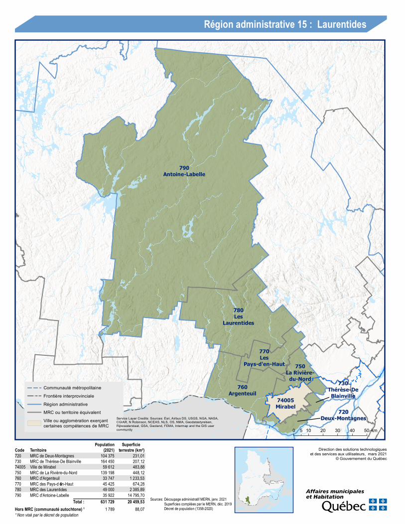
790Antoine-Labelle
780Les
Laurentides
770Les
Pays-d'en-Haut 750La Rivière-
du-Nord760
Argenteuil730
Thérèse-DeBlainville74005
Mirabel720
Deux-Montagnes
Direction des solutions technologiqueset des services aux utilisateurs, mars 2021
© Gouvernement du Québec
0 10 20 30 40 505 km
Région administrative 15 : Laurentides
Communauté métropolitaineFrontière interprovincialeRégion administrativeMRC ou territoire équivalentVille ou agglomération exerçantcertaines compétences de MRC
Service Layer Credits: Sources: Esri, Airbus DS, USGS, NGA, NASA,CGIAR, N Robinson, NCEAS, NLS, OS, NMA, Geodatastyrelsen,Rijkswaterstaat, GSA, Geoland, FEMA, Intermap and the GIS usercommunity
Code Territoire (2021)Population
terrestre (km²)Superficie
720 MRC de Deux-Mo n tag nes 104 375 231,01730 MRC de Th érèse-De Blain ville 164 450 207,1274005 V ille de Mirabel 59 612 483,88750 MRC de La Rivière-du-No rd 139 198 448,12760 MRC d'Arg en teuil 33 747 1 233,53770 MRC des Pays-d’en-Haut 45 425 674,28780 MRC des Lauren tides 49 000 2 385,89790 MRC d'An to in e-Labelle 35 922 14 795,70
Total : 631 729 20 459,53Hors MRC (communauté autochtone) ¹ 1 789 88,07¹ Non visé par le décret de population
So urces:Déco upag e adm in istratif MERN, jan v. 2021Superficies co m pilées par le MERN, déc. 2019Décret de populatio n (1358-2020)
148
13
50
15
20
640
40
Kanesatake, EI
Saint-Placide, M
Oka, M
Oka, M
Saint-Joseph-du-
Lac, M
Pointe-Calumet, M
Sainte-Marthe-sur-le-Lac, V
Deux-Montagnes, V
Saint-Eustache, V
0 94,5 km
Direction des solutions technologiqueset des services aux utilisateurs, mars 2021
© Gouvernement du Québec
Population par municipalité(décret 2021)
0 - 1 999 h.2 000 h. - 9 999 h.10 000 h. - 49 999 h.
LimitesRégion administrativeMRCCommunauté métropolitaine
Réseau routierAutorouteRoute nationaleRoute régionale
Service Layer Credits: Sources: Esri, Airbus DS, USGS, NGA, NASA, CGIAR, N Robinson, NCEAS, NLS, OS,NMA, Geodatastyrelsen, Rijkswaterstaat, GSA, Geoland, FEMA, Intermap and the GIS user community
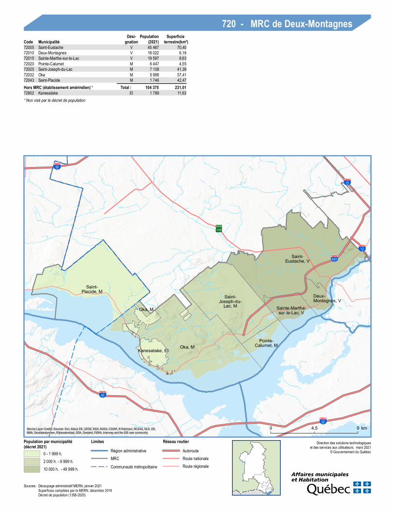
720 - MRC de Deux-MontagnesCode Municipalité
Dési-gnation (2021)
Populationterrestre(km²)
Superficie
72005 Saint-Eustache V 45 467 70,4072010 Deux-Montagnes V 18 022 6,1672015 Sainte-Marthe-sur-le-Lac V 19 597 8,6372020 Pointe-Calumet M 6 447 4,5572025 Saint-Joseph-du-Lac M 7 108 41,3972032 Oka M 5 988 57,4172043 Saint-Placide M 1 746 42,47
Total : 104 375 231,01Hors MRC (établissement amérindien) ¹72802 Kanesatake EI 1 789 11,63¹ Non visé par le décret de population
Sources: Découpage administratif MERN, janvier 2021Superficies compilées par le MERN, décembre 2019Décret de population (1358-2020)

117
148
158
13
50
19440
25640
15
Sainte-Anne-des-Plaines, V
Bois-des-Filion, VLorraine, V
Rosemère, V
Blainville, V
Sainte-Thérèse, V
Boisbriand, V
0 94,5 km
Direction des solutions technologiqueset des services aux utilisateurs, mars 2021
© Gouvernement du Québec
Population par municipalité(décret 2021)
2 000 h. - 9 999 h.10 000 h. - 49 999 h.50 000 h. - 99 999 h.
LimitesRégion administrativeMRCCommunauté métropolitaine
Réseau routierAutorouteRoute nationaleRoute régionale
Service Layer Credits: Sources: Esri, Airbus DS, USGS, NGA, NASA, CGIAR, N Robinson, NCEAS, NLS, OS,NMA, Geodatastyrelsen, Rijkswaterstaat, GSA, Geoland, FEMA, Intermap and the GIS user community
730 - MRC de Thérèse-De BlainvilleCode Municipalité
Dési-gnation (2021)
Populationterrestre(km²)
Superficie
73005 Boisbriand V 27 296 27,8373010 Sainte-Thérèse V 26 377 9,3573015 Blainville V 61 543 54,9073020 Rosemère V 14 129 10,7173025 Lorraine V 9 635 5,8973030 Bois-des-Filion V 10 045 4,4573035 Sainte-Anne-des-Plaines V 15 425 93,98
Total : 164 450 207,12
Sources: Découpage administratif MERN, janvier 2021Superficies compilées par le MERN, décembre 2019Décret de population (1358-2020)
117
148
13
640
5015
Mirabel, V
0 105 km
Direction des solutions technologiqueset des services aux utilisateurs, mars 2021
© Gouvernement du Québec
Population par municipalité(décret 2021)
50 000 h. - 99 999 h.
LimitesRégion administrativeMRCCommunauté métropolitaine
Réseau routierAutorouteRoute nationaleRoute régionale
Service Layer Credits: Sources: Esri, Airbus DS, USGS, NGA, NASA, CGIAR, N Robinson, NCEAS, NLS, OS,NMA, Geodatastyrelsen, Rijkswaterstaat, GSA, Geoland, FEMA, Intermap and the GIS user community
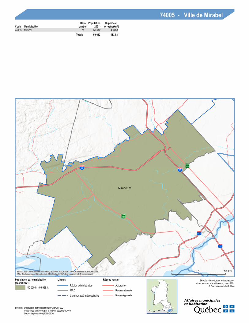
74005 - Ville de MirabelCode Municipalité
Dési-gnation (2021)
Populationterrestre(km²)
Superficie
74005 Mirabel V 59 612 483,88 Total : 59 612 483,88
Sources: Découpage administratif MERN, janvier 2021Superficies compilées par le MERN, décembre 2019Décret de population (1358-2020)
117
117
158
64050
15
Saint-Hippolyte, M
Prévost, V
Sainte-Sophie, M
Saint-Jérôme, V
Saint-Colomban, V
Saint-Colomban, V
0 105 km
Direction des solutions technologiqueset des services aux utilisateurs, mars 2021
© Gouvernement du Québec
Population par municipalité(décret 2021)
10 000 h. - 49 999 h.50 000 h. - 99 999 h.
LimitesRégion administrativeMRCCommunauté métropolitaine
Réseau routierAutorouteRoute nationaleRoute régionale
Service Layer Credits: Sources: Esri, Airbus DS, USGS, NGA, NASA, CGIAR, N Robinson, NCEAS, NLS, OS,NMA, Geodatastyrelsen, Rijkswaterstaat, GSA, Geoland, FEMA, Intermap and the GIS user community
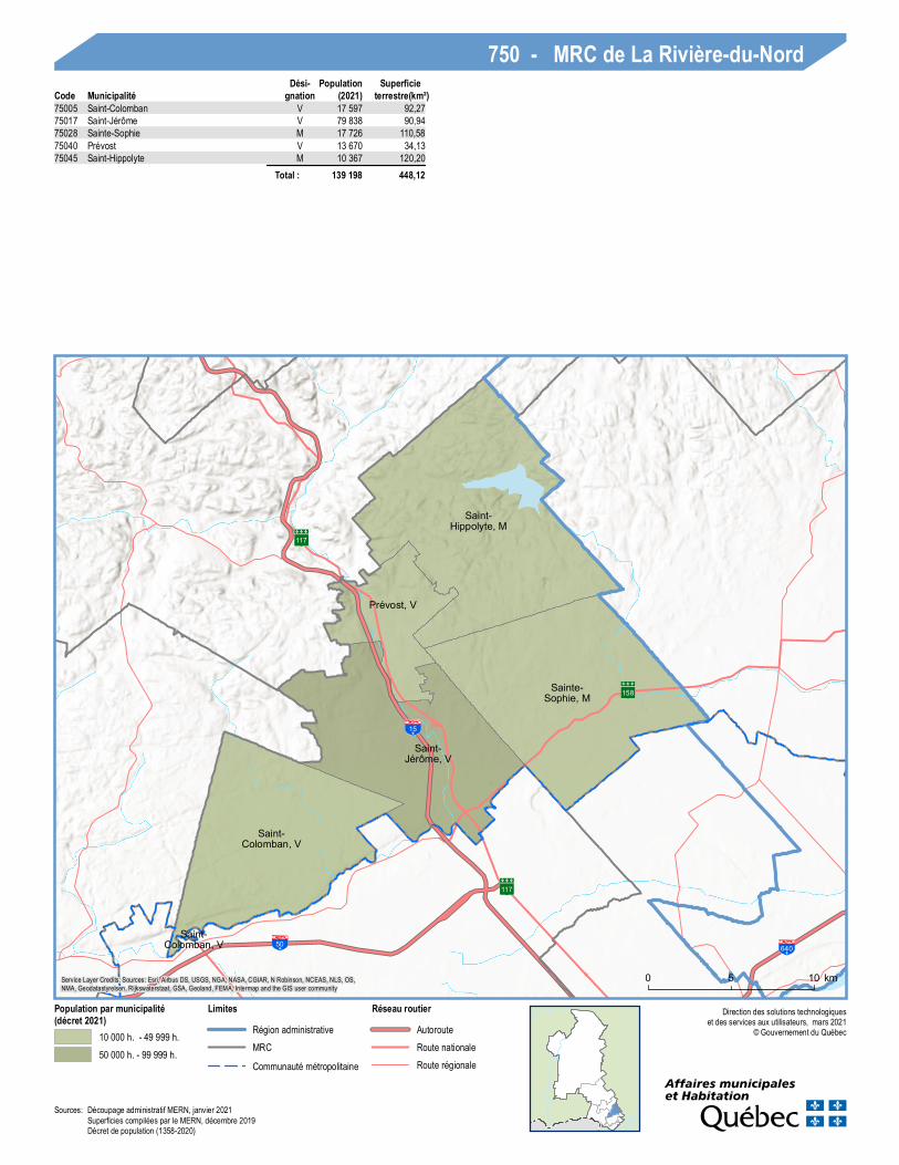
750 - MRC de La Rivière-du-NordCode Municipalité
Dési-gnation (2021)
Populationterrestre(km²)
Superficie
75005 Saint-Colomban V 17 597 92,2775017 Saint-Jérôme V 79 838 90,9475028 Sainte-Sophie M 17 726 110,5875040 Prévost V 13 670 34,1375045 Saint-Hippolyte M 10 367 120,20
Total : 139 198 448,12
Sources: Découpage administratif MERN, janvier 2021Superficies compilées par le MERN, décembre 2019Décret de population (1358-2020)

117
148
40
417
15
50
Harrington, CT
Grenville, VL
Grenville-sur-la-
Rouge, M
Brownsburg-Chatham, V
Wentworth, CT
Mille-Isles, M
Gore, CT
Lachute, V
Saint-André-d'Argenteuil, M
0 105 km
Direction des solutions technologiqueset des services aux utilisateurs, mars 2021
© Gouvernement du Québec
Population par municipalité(décret 2021)
0 - 1 999 h.2 000 h. - 9 999 h.10 000 h. - 49 999 h.
LimitesFrontière interprovincialeRégion administrativeMRCCommunauté métropolitaine
Réseau routierAutorouteRoute nationaleRoute régionale
Service Layer Credits: Sources: Esri, Airbus DS, USGS, NGA, NASA, CGIAR, N Robinson, NCEAS, NLS, OS,NMA, Geodatastyrelsen, Rijkswaterstaat, GSA, Geoland, FEMA, Intermap and the GIS user community
760 - MRC d'ArgenteuilCode Municipalité
Dési-gnation (2021)
Populationterrestre(km²)
Superficie
76008 Saint-André-d'Argenteuil M 2 964 97,8576020 Lachute V 13 653 109,9076025 Gore CT 2 069 89,3976030 Mille-Isles M 1 696 58,3176035 Wentworth CT 572 84,3376043 Brownsburg-Chatham V 7 316 244,2676052 Grenville-sur-la-Rouge M 2 834 313,3076055 Grenville VL 1 783 2,8476065 Harrington CT 860 233,36
Total : 33 747 1 233,53
Sources: Découpage administratif MERN, janvier 2021Superficies compilées par le MERN, décembre 2019Décret de population (1358-2020)
117
117
15
Saint-Adolphe-d'Howard, M
Wentworth-Nord, M
Lac-des-Seize-Îles, M Morin-
Heights, M
Saint-Sauveur, V
Sainte-Anne-des-Lacs, P
Piedmont, M
Sainte-Adèle, V
Sainte-Marguerite-
du-Lac-Masson, V Estérel, V
0 105 km
Direction des solutions technologiqueset des services aux utilisateurs, mars 2021
© Gouvernement du Québec
Popu lation par municipalité(décret 2021)
0 - 1 999 h.2 000 h. - 9 999 h.10 000 h. - 49 999 h.
LimitesRégion administrativeMRCCommunauté métropolitaine
Réseau rou tierAutorouteRoute nationaleRoute régionale
Service Layer Credits: Sources: Esri, Airbus DS, USGS, NGA, NASA, CGIAR, N Robinson, NCEAS, NLS, OS,NMA, Geodatastyrelsen, Rijkswaterstaat, GSA, Geoland, FEMA, Intermap and the GIS user community
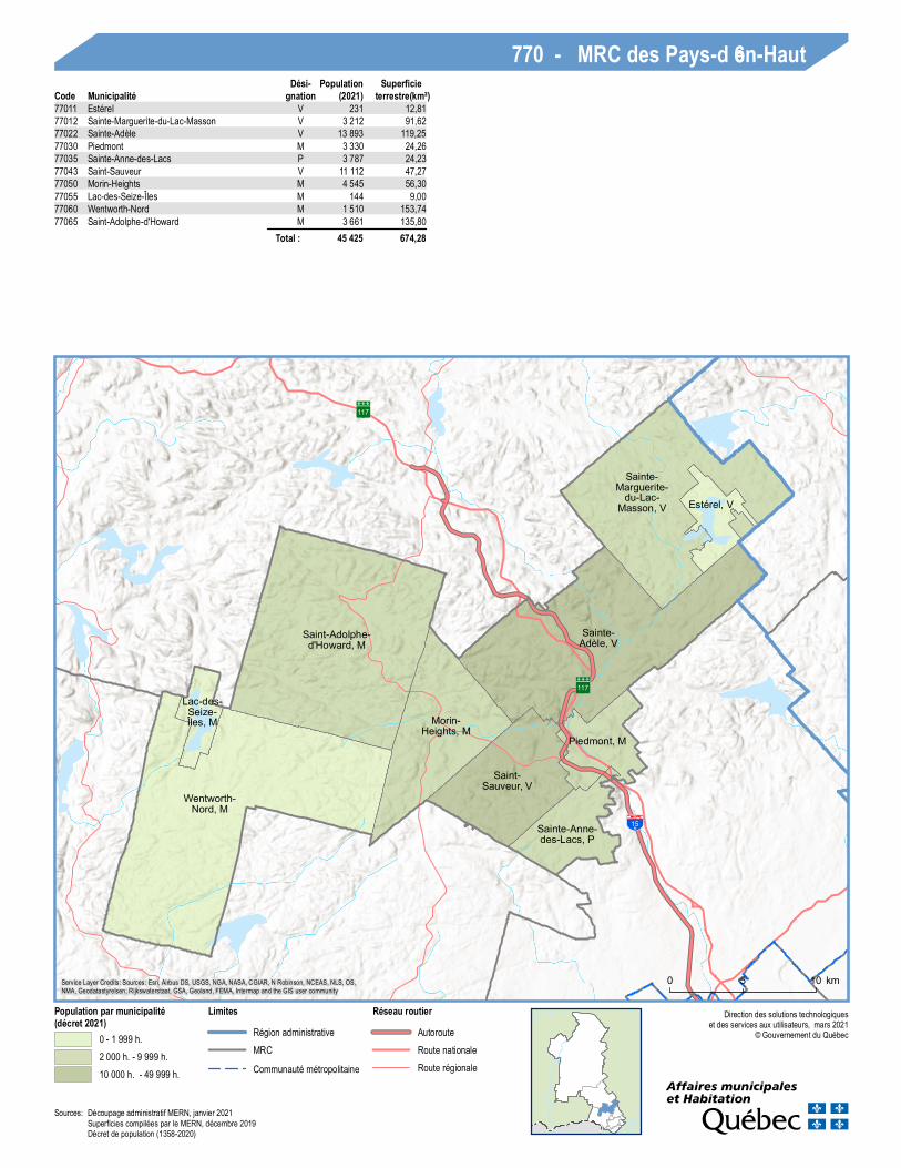
770 - MRC des Pays-d’en-HautCode Municipalité
Dési-gnation (2021)
Popu lationterrestre(km²)Superficie
77011 Estérel V 231 12,8177012 Sainte-Marguerite-du-Lac-Masson V 3 212 91,6277022 Sainte-Adèle V 13 893 119,2577030 Piedmont M 3 330 24,2677035 Sainte-Anne-des-Lacs P 3 787 24,2377043 Saint-Sauveur V 11 112 47,2777050 Morin-Heights M 4 545 56,3077055 Lac-des-Seize-Îles M 144 9,0077060 Wentworth-Nord M 1 510 153,7477065 Saint-Adolphe-d'Howard M 3 661 135,80
Total : 45 425 674,28
Sources: Découpage administratif MERN, janvier 2021Superficies compilées par le MERN, décembre 2019Décret de population (1358-2020)
117
117
117
117
15
Val-Morin, M
Doncaster, R
La Minerve, M
Lac-Tremblant-Nord, M
Labelle, M
La Conception, M Mont-Tremblant, V
Val-des-Lacs, M
Lac-Supérieur, M
Brébeuf, P
Amherst, CT
Huberdeau, M
Arundel, CTMontcalm, M
Barkmere, V
Saint-Faustin--
Lac-Carré, M Ivry-sur-le-Lac, M
Sainte-Agathe-des-
Monts, V
Sainte-Lucie-des-
Laurentides, M
Lantier, M
Val-David, VL
0 10 205 km
Direc tion des solu tions tec h nolog iqu eset des services aux u tilisateu rs, mars 2021
© Gouvernement d u Q u ébec
Population par municipalité(décret 2021)
0 - 1 999 h.2 000 h. - 9 999 h.10 000 h. - 49 999 h.
Limites administrativesRég ion ad m inistrativeMRC
Réseau routierAu torou teRou te nationaleRou te rég ionale
Service Layer Cred its: Sou rces: Esri, Airbu s DS, USGS, NGA, NASA, CGIAR, N Robinson, NCEAS, NLS, OS,NMA, Geod atastyrelsen, Rijkswaterstaat, GSA, Geoland , FEMA, Interm ap and the GIS u ser com m u nity
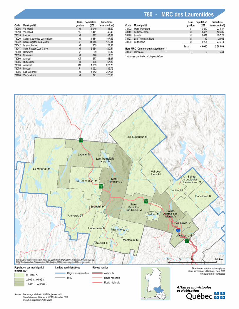
780 - MRC des LaurentidesCode Municipalité
Dési-gnation (2021)
Populationterrestre(km²)
SuperficieCode Municipalité
Dési-gnation (2021)
Populationterrestre(km²)
Superficie
78005 Val-Morin M 3 040 38,5978010 Val-David VL 5 441 42,4978015 Lantier M 892 47,8978020 Sainte-Lu c ie-des-Lau rentid es M 1 384 107,6578032 Sainte-Ag athe-des-Monts V 11 045 129,8478042 Ivry-su r-le-Lac M 359 29,3378047 Saint-Fau stin–Lac-Carré M 3 684 120,5478050 Barkm ere V 59 18,3278055 Montcalm M 628 118,2678060 Aru ndel CT 577 63,6778065 Huberdeau M 886 57,2878070 Am herst CT 1 509 227,7878075 Brébeu f P 1 052 35,7278095 Lac-Su périeu r M 1 942 367,6478100 Val-des-Lacs M 741 126,60
78102 Mont-Tremblant V 10 510 233,4778115 La Conception M 1 431 126,8578120 Labelle M 2 479 197,2078127 Lac-Tremblant-Nord M 47 20,6278130 La Minerve M 1 294 276,14
Total : 49 000 2 385,89Hors MRC (Communauté autochtone) ¹78802 Doncaster R 0 76,44¹ Non visé par le décret de population
Sou rces:Décou page ad m inistratif MERN, janvier 2021Su perfic ies com pilées par le MERN, décembre 2019Décret de popu lation (1358-2020)
117
105
117
Lac-De LaBidière, NO
Lac-Bazinet, NO
Lac-Oscar, NOLac-
Douaire, NOLac-de-la-
Pomme, NOLac-
Marguerite, NO
Ferme-Neuve, M
Sainte-Anne-du-Lac, M
Lac-de-la-Maison-de-Pierre, NO
Mont-Saint-
Michel, M
Lac-Saint-
Paul, M
Baie-des-Chaloupes, NO
Chute-Saint-
Philippe, M
Rivière-Rouge, V
Mont-Laurier, V
Lac-Douaire, NO
L'Ascension, MLac-
Saguay, VL
Lac-des-Écorces, M
Kiamika, M
La Macaza, M
Nominingue, M
Saint-Aimé-du-Lac-des-
Îles, M
Notre-Dame-de-
Pontmain, M Lac-Ernest, NO
Lac-du-Cerf, M Rivière-
Rouge, V
Notre-Dame-du-Laus, M
Lac-De LaBidière, NO
Lac-Bazinet, NO
Lac-Wagwabika, NO
Lac-Oscar, NOLac-
Douaire, NOLac-de-la-
Pomme, NOLac-Marguerite, NO
Ferme-Neuve, M
Sainte-Anne-du-Lac, M Lac-de-la-
Maison-de-Pierre, NO
0 10 20 30 40 505 km
Direction des solutions technologiqueset des services aux utilisateurs, mars 2021
© Gouvernement du Québec
Population par municipalité(décret 2021)
0 - 1 999 h.2 000 h. - 9 999 h.10 000 h. - 49 999 h.
LimitesRégion administrativeMRC
Réseau routierAutorouteRoute nationaleRoute régionale
Service Layer Credits: Sources: Esri, Airbus DS, USGS, NGA, NASA, CGIAR, N Robinson, NCEAS, NLS, OS,NMA, Geodatastyrelsen, Rijkswaterstaat, GSA, Geoland, FEMA, Intermap and the GIS user community
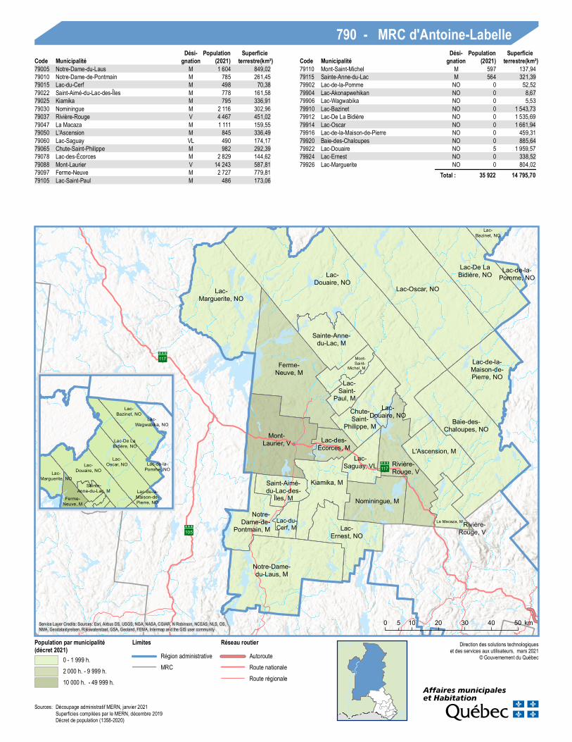
790 - MRC d'Antoine-LabelleCode Municipalité
Dési-gnation (2021)
Populationterrestre(km²)
SuperficieCode Municipalité
Dési-gnation (2021)
Populationterrestre(km²)
Superficie
79005 Notre-Dame-du-Laus M 1 604 849,0279010 Notre-Dame-de-Pontmain M 785 261,4579015 Lac-du-Cerf M 498 70,3879022 Saint-Aimé-du-Lac-des-Îles M 778 161,5879025 Kiamika M 795 336,9179030 Nominingue M 2 116 302,9679037 Rivière-Rouge V 4 467 451,0279047 La Macaza M 1 111 159,5579050 L'Ascension M 845 336,4979060 Lac-Saguay VL 490 174,1779065 Chute-Saint-Philippe M 982 292,3979078 Lac-des-Écorces M 2 829 144,6279088 Mont-Laurier V 14 243 587,8179097 Ferme-Neuve M 2 727 779,8179105 Lac-Saint-Paul M 486 173,06
79110 Mont-Saint-Michel M 597 137,9479115 Sainte-Anne-du-Lac M 564 321,3979902 Lac-de-la-Pomme NO 0 52,5279904 Lac-Akonapwehikan NO 0 8,6779906 Lac-Wagwabika NO 0 5,5379910 Lac-Bazinet NO 0 1 543,7379912 Lac-De La Bidière NO 0 1 535,6979914 Lac-Oscar NO 0 1 661,9479916 Lac-de-la-Maison-de-Pierre NO 0 459,3179920 Baie-des-Chaloupes NO 0 885,6479922 Lac-Douaire NO 5 1 959,5779924 Lac-Ernest NO 0 338,5279926 Lac-Marguerite NO 0 804,02
Total : 35 922 14 795,70
Sources: Découpage administratif MERN, janvier 2021Superficies compilées par le MERN, décembre 2019Décret de population (1358-2020)