reconstitution de la variabilité naturelle climatique et
TRANSCRIPT

Reconstitution de la variabilité naturelle climatique et océanographique dans l’estuaire et le golfe du Saint-Laurent au
cours des 10,000 dernières années
Thèse présentée
dans le cadre du programme de doctorat en océanographie
en vue de l’obtention du grade de Philosophiae doctor (Ph.D.)
PAR
© MARIE CASSE
Avril 2018

Composition du jury :
Gwenaëlle Chaillou, président du jury, UQAR
Jean-Carlos Montero Serrano, directeur de recherche, UQAR-ISMER
Guillaume St-Onge, codirecteur de recherche, UQAR-ISMER
Germain Bayon, examinateur externe, IFREMER
Dépôt initial le 7 novembre 2017 Dépôt final le 13 avril 2018

UNIVERSITÉ DU QUÉBEC À RIMOUSKI Service de la bibliothèque
Avertissement
La diffusion de ce mémoire ou de cette thèse se fait dans le respect des droits de son auteur, qui a signé le formulaire « Autorisation de reproduire et de diffuser un rapport, un mémoire ou une thèse ». En signant ce formulaire, l’auteur concède à l’Université du Québec à Rimouski une licence non exclusive d’utilisation et de publication de la totalité ou d’une partie importante de son travail de recherche pour des fins pédagogiques et non commerciales. Plus précisément, l’auteur autorise l’Université du Québec à Rimouski à reproduire, diffuser, prêter, distribuer ou vendre des copies de son travail de recherche à des fins non commerciales sur quelque support que ce soit, y compris l’Internet. Cette licence et cette autorisation n’entraînent pas une renonciation de la part de l’auteur à ses droits moraux ni à ses droits de propriété intellectuelle. Sauf entente contraire, l’auteur conserve la liberté de diffuser et de commercialiser ou non ce travail dont il possède un exemplaire.

« L’imagination est plus
importante que la connaissance (Albert
Einstein) »

v

REMERCIEMENTS
Je tiens tout d’abord à remercier mon directeur de thèse, Jean-Carlos Montero
Serrano qui a su m’accorder toute sa confiance lors de ces années de recherche ainsi qu’une
grande autonomie dans l’organisation de mon travail. Merci Jean pour ta grande
disponibilité et pour nos nombreuses discussions scientifiques qui m’ont permis d’aborder
les difficultés sous un autre angle. Je tiens également à remercier mon co-directeur
Guillaume St-Onge pour m’avoir intégrée à part entière au sein du laboratoire de recherche,
pour ses conseils judicieux, sa motivation et son énergie à développer sans cesse de
nouveaux projets.
Merci à André Poirier, fin connaisseur de l’ICP-MS et du TIMS, pour sa perpétuelle
bonne humeur lors de mes séjours au Geotop (en passant, merci au Benelux !). Merci à
Mathieu Babin pour sa gentillesse et sa patience, qui a réussi à me supporter lors de mes -
multiples - infinies – interminables mesures de terres rares. Merci à Denis Gilbert pour ses
explications sur la circulation des masses d’eau du Saint-Laurent, et pour son accueil à
l’Institut Maurice Lamontagne. Merci à Quentin Beauvais, pour toutes les fois où je t’ai
sollicité pour des données et des fichiers introuvables, et pour avoir emballé et déballé des
carottes comme si c’était une véritable passion! Merci à ma fine équipe de collègues du
laboratoire de géologie marine !
Ce travail n’aurait pas été possible sans le soutien financier attribué par le Fonds de
recherche du Québec - Nature et technologies (FRQ-NT), qui m’a permis, grâce à une
bourse de recherche de me consacrer pleinement à l’élaboration de ma thèse. Merci au
GEOTOP pour m’avoir accordé une bourse supplémentaire.
vii
Merci à toutes les courges ! Et il y en a eu un paquet ! Merci Gigi, Camille, Kev,
Léo, Eliott, Eloisa, Charles, Agathe, Jeremy B., Jeremy T., Marie B., Elissa, Alissa,
Laurence, Tristan, Alex, Anaïs, Sarah, Steven (oui, voici toutes les courges !!) pour la vie
au quotidien avec vous qui m’a offert un bel exutoire pour me vider la tête. Merci aux
débats endiablés, aux nombreux projets communautaires et culturels, à la kombucha, au
cidre, à l’hydromel, à la bière, au levain, au kéfir, aux ateliers artistiques, au potager qui ont
chacun trouvé leur place à la maison… Merci à mes partenaires d’escalade, de swing, de
dessin, et de cueillette de champignons ! Merci à Maëva et Clémence d’exister et d’être
mes fidèles confidentes! Puis à Jéremy et Jojo pour me faire voir la vie autrement ! Merci à
Polan pour les petites escapades passées ensemble, en paddle ou en grimpe! Et, merci aux
ami-e-s de Bordeaux, les grands passionnés de géologie, avec qui j’ai développé un amour
pour les sciences naturelles et l’étude des cailloux!
On m’a dit une fois que faire une thèse, c’est comme embarquer sur des montagnes
russes, il y a des hauts et des bas ! Avec de nombreuses descentes très rapides ! Dans ces
descentes, mes parents ont été les seules personnes capables à me faire réaliser l’essentiel.
La vie ne s’accomplit pas que dans le travail, mais plutôt dans la recherche d’un
épanouissement personnel. « Peu importe ce que tu fais, tant que tu es heureuse on te
soutiendra ». Voilà, cette phrase résume tout, rien que pour cela je vous dis 1000 fois merci.
Merci de me soutenir dans mes projets, de m’accorder votre confiance et votre écoute dans
n’importe quelle situation.
Maintenant, je laisse place à l’inconnu, aux voyages, à l’inattendu. Merci à Eliott
qui m’accompagne dans de futurs projets d’aventure et de découverte, qui je l’espère,
seront aussi enrichissants que l’expérience vécue ces derniéres années sur cette belle terre
canadienne.

RÉSUMÉ
L’estuaire et le golfe du Saint-Laurent (EGSL, Est du Canada) sont des milieux très dynamiques d’un point de vue sédimentaire. Pourtant, les voies de propagation des sédiments fluviaux ainsi que l’origine et le mélange des apports sédimentaires en milieu marin ne sont pas bien documentés dans cette zone. Or, ces connaissances sont fondamentales pour déterminer les sources principales des apports terrigènes et mieux comprendre la dynamique de ce système sédimentaire. Dans ce contexte, les propriétés physiques, la distribution granulométrique, la minéralogie, les éléments majeurs et traces, et les isotopes radiogéniques (néodyme et strontium) d’un ensemble de sédiments de surface et de carottes sédimentaires de l’EGSL ont été étudiées dans cette thèse afin d’évaluer et mieux documenter la variabilité climatique et océanographique naturelle au cours des 10000 dernières années (période Holocène). L’ensemble des données obtenues dans cette thèse permettent de : (1) documenter à long terme les relations qui existent entre les changements au sein de la dynamique sédimentaire et les changements climatiques et océanographiques majeurs survenus dans l’EGSL au cours de l’Holocène, et (2) d’améliorer la compréhension globale des principaux processus sédimentologiques et géochimiques opérants dans l’EGSL.
Dans le Chapitre 1, les données de minéralogie et de géochimie (éléments majeurs)
ont permis de reconstituer la nature, l’origine et le transport des sédiments détritiques dans l’EGSL au cours de l’Holocène. L’analyse et la comparaison des différents traceurs détritiques ont permis de mettre en évidence deux régimes sédimentaires distincts dans l’EGSL au cours de l’Holocène. Au début de l’Holocène (10–8,5 cal. ka BP) les fortes décharges d’eau issues de la fonte de la calotte de glace Laurentienne contrôlent la dynamique sédimentaire dans l’EGSL. Cependant, à partir de 8,5 cal ka BP, les variations du niveau marin relatif provoquées par le rebond isostatique postglaciaire de la croûte continentale exercent un contrôle significatif sur le transfert de sédiment dans l’EGSL.
Dans le Chapitre 2, la comparaison entre les compositions isotopiques en néodyme
(Nd) et strontium (Sr) ainsi que la distribution des terres rares (REEs) extraites des échantillons d’eau de mer et dans la fraction authigénique et détritique de plusieurs échantillons de sédiments de surface recueillis dans le chenal Laurentien ont permis d’évaluer le potentiel qu’ont les isotopes du Nd comme traceurs isotopiques des masses d’eau profonde dans l’EGSL. Les résultats obtenus suggèrent que la composition isotopique en Nd dans l’EGSL ne permet pas de tracer l’origine et/ou le mélange des

ix
masses d’eau, mais plutôt d’identifier l’origine des différentes sources sédimentaires (ex. sédiments dérivés des roches métamorphiques et ignées du bouclier canadien vs. sédiments dérivés des roches sédimentaires appartenant aux Appalaches). De ce fait, nos résultats attestent que les isotopes radiogéniques forment de puissants outils pour retracer l’évolution des conditions d’altération continentale dans l’EGSL au cours du temps.
Dans le Chapitre 3, nous avons reconstitué l’évolution des conditions d’altération
continentale dans l’EGSL au cours de l’Holocène à partir de la composition isotopique du Nd obtenue dans la fraction authigénique de deux carottes sédimentaires recuillies dans le chenal Laurentien. Les valeurs εNd très peu radiogéniques enregistrées dans les sédiments au début de l’Holocène sont caractéristiques des sédiments provenant de la Côte-Nord. Ces données très peu radiogéniques sont en lien avec les très fortes décharges d’eau de fonte de la calotte de glace Laurentienne au début de l’Holocène qui érodent principalement le socle rocheux du bouclier canadien. Les résultats obtenus dans ce chapitre prouvent que les compositions isotopiques en Nd obtenues dans les sédiments de l’EGSL constituent un outil robuste pour évaluer les changements océanographiques et sédimentaires majeurs au cours de l’Holocène.
Dans l’ensemble, la contribution principale de cette thèse est en premier lieu
l’établissement d’une nouvelle base de données grâce à laquelle il est possible de mettre en évidence l’évolution de la dynamique sédimentaire dans l’EGSL au cours de l’Holocène. De plus, ces résultats permettent d’identifier les principaux facteurs climatiques et océanographiques exerçant un contrôle sur le transfert de sédiments dans l’EGSL, rendant possible une reconstitution plus complète de son histoire environnementale depuis la dernière déglaciation.
Mots clés : Estuaire et Golfe du Saint-Laurent ; Holocène ; calotte de glace
Laurentienne ; niveau marin relatif ; dynamique sédimentaire ; minéralogie ; géochimie ; isotopes radiogéniques ; terres rares.
ABSTRACT
The Estuary and Gulf of St. Lawrence (EGSL, Eastern Canada) are very dynamic environments from a sedimentary point of view. However, the origin, the mixing and the propagation of fluvial terrigenous sediments are not well understood in this area. Having a proper knowledge of these components is of primary importance to determine the main sedimentary sources as well as to understand the sedimentary dynamics in the EGSL. In this context, physical properties of sediments, grain-size, mineralogy, trace elements and radiogenic isotopes (neodymium and strontium) of surface sediments and sediment cores were analysed to evaluate and document the climatic and oceanographic variability over the past 10,000 years in the EGSL. The whole data acquired during this thesis will help (1) to document the potential long-term relationships between the variability in the sediment dynamics and major climatic and oceanographic changes during the Holocene, and (2) to improve the overall understanding of the main sedimentological and geochemical processes operating in the EGSL.
In Chapter 1, mineralogical and geochemical data of major elements have led to reconstruct the changes in the origin and transport of detrital sediments in the EGSL during the Holocene. The analysis and comparison of our detrital proxies revealed two distinct sedimentary regimes in the EGSL during this period. At the beginning of the Holocene (10-8.5 cal. ka BP), the meltwater discharge from the deglaciation of the Laurentide Ice Sheet seems to control the EGSL sediment dynamics. Later on, from 8.5 cal ka BP up to present, changes in the relative sea level caused by isostatic postglacial rebound of the continental crust exert a significant control on EGSL sediment transfer.
In Chapter 2, the comparison between the neodymium (Nd) and strontium (Sr) isotopic compositions and rare earth elements distribution (REEs) were analyzed in seawater samples and in the authigenic and detrital fractions of several surface sediment samples from the Laurentian channel. This was performed to evaluate the potential of Nd isotopes as a proxy to identify the bottom seawater masses in the EGSL. Our results suggest that the Nd isotopic composition recorded in the EGSL is not linked to the origin and mixing of seawater masses, but rather to the detrital particulates related to different continental sediment sources (e.g, sediments derived from metamorphic and igneous rocks of the Canadian Shield vs. sediments derived from Appalachian sedimentary rocks). Based on our results, the radiogenic isotopes represent powerful tools to trace the evolution of continental weathering in the EGSL over time.

xi
In Chapter 3, we retraced the evolution of the continental weathering conditions over the last 10,000 years in the EGSL using the Nd isotopic composition obtained in the authigenic fraction of two sedimentary cores from the Laurentian channel. The unradiogenic εNd values recorded in sediments at the beginning of the Holocene are characteristic of a north shore origin. These values are related to the meltwater discharge from the deglaciation of the Laurentide ice sheet, causing erosion and weathering of the continental rocks and sediments of the north coast. These results show that the Nd isotopic composition obtained in EGSL sediments constitute a useful proxy for assessing the major oceanographic and sedimentary changes during the Holocene.
Overall, the main contribution of this thesis is the establishment of a new dataset, highlighting the sediment dynamics in the EGSL during the Holocene. Based on our results, it is possible to identify the main climatic and oceanographic forces acting on the sedimentary dynamics, allowing us to establish the global environmental history of the EGSL since the last deglaciation.
Keywords: Estuary and gulf of St.Lawrence ; Holocene ; Laurentide Ice Sheet ; relative sea level ; sedimentary dynamic ; mineralogy ; geochemistry ; radiogenic isotopes ; rare earth elements.

TABLE DES MATIÈRES
REMERCIEMENTS ............................................................................................................. vi
RÉSUMÉ ............................................................................................................................. viii
ABSTRACT ........................................................................................................................... x
TABLE DES MATIÈRES .................................................................................................... xii
LISTE DES TABLEAUX ................................................................................................. xviii
LISTE DES FIGURES ........................................................................................................ xix
LISTE DES ABRÉVIATIONS, DES SIGLES ET DES ACRONYMES ...................... xxviii
LISTE DES SYMBOLES .................................................................................................. xxx
INTRODUCTION GÉNÉRALE ....................................................................................... 31
INTRODUCTION À LA PROBLEMATIQUE ................................................................... 32
CONTEXTE POSTGLACIAIRE ET VARIATIONS DU NIVEAU MARIN
RELATIF .............................................................................................................................. 32
UNITÉ STRATIGRAPHIQUE AU COURS DE LA DÉGLACIATION ........................... 37
NATURE ET ORIGINE DES SÉDIMENTS ....................................................................... 38
CIRCULATION ESTUARIENNE ...................................................................................... 41
GÉNÉRALITÉ SUR LA COMPOSITION ISOTOPIQUE EN NÉODYME DES
DIFFÉRENTES ROCHES À LA SURFACE DE LA TERRE ............................................ 45
LE CYCLE DU NÉODYME DANS L’OCÉAN ................................................................. 50
xiii
DISTRIBUTION ET FRACTIONNEMENT DES TERRES RARES ................................ 54
OBJECTIFS DE RECHERCHE ........................................................................................... 57
METHODOLOGIE .............................................................................................................. 63
ORGANISATION DE LA THÈSE ...................................................................................... 77
CHAPITRE 1 ...................................................................................................................... 80
Influence de la calotte de glace Laurentienne et des variations du niveau marin
relatif sur la dynamique sédimentaire dans l’Estuaire et le Golfe du Saint-
Laurent depuis la derniÈre déglaciation .......................................................................... 80
1.1. RÉSUMÉ EN FRANÇAIS DU PREMIER ARTICLE .............................................................. 80
1.2. INTRODUCTION .................................................................................................... 82
1.3. PHYSIOGRAPHIC AND GEOLOGICAL SETTING OF THE ESTUARY AND GULF OF ST.
LAWRENCE ................................................................................................................ 84
1.4. MATERIAL AND METHODS.......................................................................................... 89
1.4.1. Samples .............................................................................................................. 89
1.4.2. Chronostratigraphic framework ......................................................................... 90
1.4.3. Analytical procedure .......................................................................................... 91
1.4.3.1. Physical properties: Multisensor Core Logger analyses. ................................... 91
1.4.3.2. Grain size distribution and end-member modelling analysis. .................. 92
1.4.3.3. Bulk sediment mineralogy. ....................................................................... 93
1.4.3.4. Elemental geochemistry..................................................................................... 94
1.4.3.5. Magnetic remanence analyses. ................................................................. 94
1.4.3.6. Statistical approach ............................................................................................ 95
1.5. RESULTS ................................................................................................................. 98
1.5.1. Sediment characteristics and chronostratigraphic framework ........................... 98
1.5.2. Grain-size end-member ..................................................................................... 99
xiv
1.5.3. Mineralogical and geochemical associations................................................... 101
1.5.4. Laurentian Channel sediment cores ................................................................. 106
1.5.4.1. Lower St. Lawrence Estuary: Core COR0602-36PC. ..................................... 106
1.5.4.2. South of Anticosti Island: Core COR0503-CL05-37PC. ....................... 107
1.5.4.3. Cabot Strait: Core COR0503-CL04-36PC. ..................................................... 108
1.5.5. Interpretation and discussion ........................................................................... 109
1.5.5.1. Sedimentary regime during deglaciation (10–8.5 ka) — meltwater
discharges ........................................................................................................ 111
1.5.5.2. Sedimentary regime during the Holocene (8.5 cal. ka BP to present) —
postglacial relative sea-level variations ........................................................... 113
1.6. CONCLUSIONS ........................................................................................................ 117
1.7. ACKNOWLEDGEMENTS. ........................................................................................... 119
1.8. REFERENCES. ........................................................................................................... 120
CHAPITRE 2 .................................................................................................................... 128
Étude des concentrations en REEs et des compositions isotopiques en Nd et Sr
obtenues sur des sédiments de surface de l’est du Canada : extraction du signal
d’eau de mer et provenance détritique ........................................................................... 128
2.1. RÉSUMÉ EN FRANÇAIS DU DEUXIÈME ARTICLE ......................................................... 128
2.2. INTRODUCTION ........................................................................................................ 130
2.3. ENVIRONMENTAL SETTING ...................................................................................... 134
2.3.1. Regional morphology and geological setting .................................................. 134
2.3.2. Hydrological setting......................................................................................... 135
2.3.3. Seawater and sediment εNd and 87Sr/86Sr variations in eastern Canada and
adjacent continental shelves ............................................................................ 137
2.4. MATERIAL AND METHODS ....................................................................................... 138
2.4.1. Samples ............................................................................................................ 138
xv
2.4.2. Analytical procedures ...................................................................................... 140
2.4.2.1. Seawater treatment........................................................................................... 140
2.4.2.2. Bulk sediment leaching.................................................................................... 141
2.4.2.3. Bulk sediment digestion (detrital fraction) ...................................................... 142
2.4.2.4. Column chemistry: Sr and Nd separation ........................................................ 143
2.4.2.5. REE concentrations and Sr-Nd analysis .......................................................... 143
2.5. RESULTS .................................................................................................................. 145
2.5.1. Seawater physical properties ........................................................................... 145
2.5.2. Rare earth element concentrations ................................................................... 146
2.5.3. Strontium isotope signatures ........................................................................... 149
2.5.4. Neodymium isotope signatures ....................................................................... 150
2.6. DISCUSSION ............................................................................................................. 153
2.6.1. Reliable extraction of the seawater signal: Seawater versus bulk sediment
leachates ........................................................................................................... 154
2.6.1.1. Vertical distribution of REEs throughout the seawater column ...................... 154
2.6.1.2. Distribution of REEs in leachate bulk sediment samples ................................ 157
2.6.1.3. Dissolved-particulate interactions of REEs ..................................................... 158
2.6.1.4. Strontium and neodymium isotope signatures ................................................. 160
2.6.2. Sediment provenance ....................................................................................... 164
2.6.2.1. Detrital REE patterns ....................................................................................... 164
2.6.2.2. Detrital strontium and neodymium isotope signatures .................................... 165
2.7. SUMMARY AND CONCLUSION ................................................................................... 168
2.8. ACKNOWLEDGEMENTS ............................................................................................ 170
2.9. REFERENCES ............................................................................................................ 171
CHAPITRE 3 .................................................................................................................... 187

xvi
Evaluation de la dynamique sédimentaire dans l’Estuaire et le Golfe du Saint-
Laurent au cours de l’Holocène par la composition isotopique en Nd et les
concentrations en REEs. .................................................................................................. 187
3.1. RÉSUMÉ EN FRANÇAIS DU TROISIÈME ARTICLE ......................................................... 187
3.2. INTRODUCTION ........................................................................................................ 189
3.3. ENVIRONMENTAL AND GEOLOGICAL SETTINGS ........................................................ 192
3.4. MATERIAL AND METHODS........................................................................................ 195
3.4.1. Samples ............................................................................................................ 195
3.4.2. Chronostratigraphic framework ....................................................................... 196
3.4.3. Analytical procedures ...................................................................................... 198
3.4.3.1. Bulk sediment leaching.................................................................................... 198
3.4.3.2. Sr and Nd separation: column chemistry ........................................................ 198
3.4.3.3. REE concentrations and Sr-Nd analysis .......................................................... 199
3.5. RESULTS .................................................................................................................. 201
3.5.1. Sediment characteristics and chronostratigraphic framework ......................... 201
3.5.2. Rare earth element distribution ........................................................................ 201
3.5.3. Strontium isotope signatures ........................................................................... 203
3.5.4. Neodymium isotope signatures ....................................................................... 204
3.6. DISCUSSION ............................................................................................................. 205
3.6.1. Significance of the ɛNd signatures and geochemical composition of bulk
sediment leachates ........................................................................................... 205
3.6.2. Deglacial−Holocene sediment dynamics in the Estuary and Gulf of St.
Lawrence.......................................................................................................... 210
3.6.2.1. Influence of meltwater discharges on the sedimentary dynamic (10–8 ka) ... 211
3.6.2.2. Sedimentary regime during the Holocene and establishment of the current
stable oceanic conditions (8 cal. ka BP to present) ......................................... 214
3.7. SUMMARY AND CONCLUSIONS ................................................................................. 219

xvii
3.8. ACKNOWLEDGEMENTS ............................................................................................ 220
3.9. REFERENCES ............................................................................................................ 221
CONCLUSIONS GÉNÉRALES ET PERSPECTIVES ................................................ 234
EVOLUTION DE LA DYNAMIQUE SEDIMENTAIRE DANS L’ESTUAIRE ET
LE GOLFE DU SAINT-LAURENT DEPUIS 10000 ANS ............................................... 237
CALIBRATION DE LA COMPOSITION ISOTOPIQUE EN NÉODYME ET EN
STRONTIUM ..................................................................................................................... 242
ISOTOPES RADIOGÉNIQUES ET CONCENTRATIONS EN ELEMENTS
TRACES ET TERRES RARES COMME TRACEURS DE SOURCES
CONTINENTALES DANS L’EGSL ................................................................................. 246
ANNEXE 1 ......................................................................................................................... 254
ANNEXE 2 ......................................................................................................................... 255
ANNEXE 3 ......................................................................................................................... 256
ANNEXE 4 ......................................................................................................................... 257
ANNEXE 5 ......................................................................................................................... 258
ANNEXE 6 ......................................................................................................................... 259
RÉFÉRENCES BIBLIOGRAPHIQUES ........................................................................... 260

LISTE DES TABLEAUX
Table 1. Coordinates and lengths of the three sedimentary piston cores studied herein. ..... 89
Table 2. Location of sediment samples with the corresponding seawater depth. .............. 139
Table 3. Location of seawater samples together with the hydrological parameters. The salinity, potential temperature, and potential density obtained from the five seawater stations (COR1503-07, COR1207-007, COR1207-003, COR1206-025, and COR1206-030) are indicated. ............................................................................................. 140
Tableau 4. REE concentrations from the five seawater stations (pmol/kg) and from the detrital (ppm) and authigenic (ppb) phase of marine sediments. REE were normalized to Post Archaean Australian Shale (Pourmand et al. 2012). ........................... 256
Tableau 5. Neodymium and strontium isotope composition obtained from the five seawater stations and from leached and detrital sediments. ............................................... 257
Tableau 6. REE concentrations obtained from the authigenic phase of the two sediment cores COR0602-36PC (estuary) and COR0503-CL04-36PC (gulf). The ratio (HREE/LREE)n= (Tm+Yb+Lu)n/(La+Ce+Pr+Nd)n, (MREE)*n=(2[Gd+Tb+Dy]n/[HREE+LREE]n) and (Eu/Eu*)n = (2*Eu)n/(Sm+Ga)n are reported. All the REE were normalized to Post Archaean Australian Shale (PAAS, Pourmand et al. 2012). .......................................................................................... 258
Tableau 7. Neodymium and strontium isotopic composition obtained from the bulk leached sediments of the two sedimentary cores COR0602-36PC (estuary) and COR0503-CL04-36PC (gulf). ............................................................................................ 259
LISTE DES FIGURES
Figure 1. Bathymétrie de l’EGSL (modifié de Shaw et al. 2006). Les principaux chenaux et détroits sont spécifiés. ........................................................................................ 33
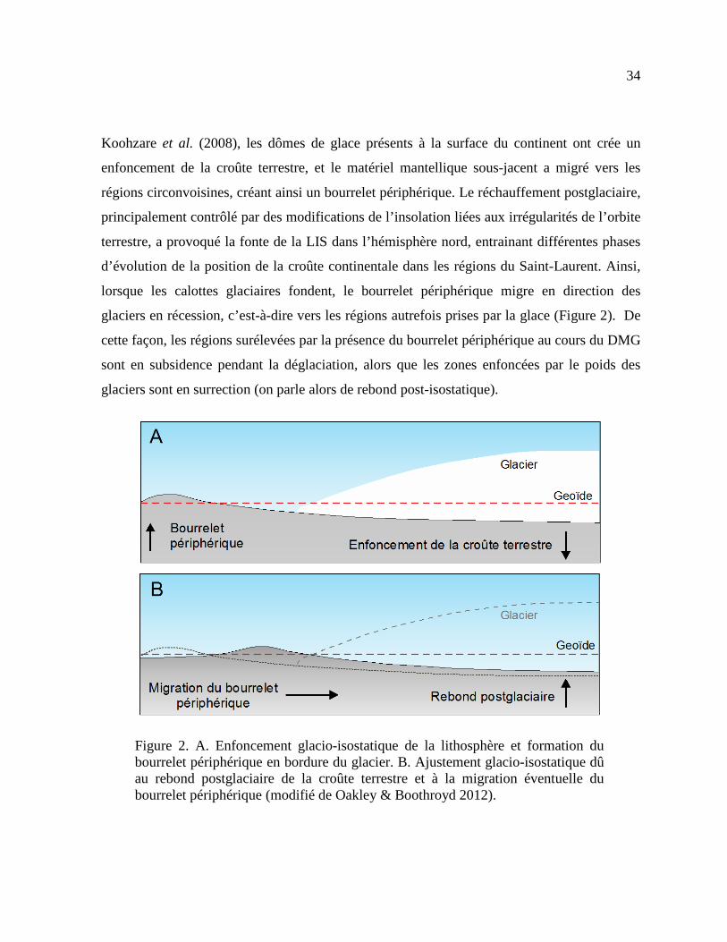
Figure 2. A. Enfoncement glacio-isostatique de la lithosphère et formation du bourrelet périphérique en bordure du glacier. B. Ajustement glacio-isostatique dû au rebond postglaciaire de la croûte terrestre et à la migration éventuelle du bourrelet périphérique (modifié de Oakley & Boothroyd 2012). ........................................................ 34
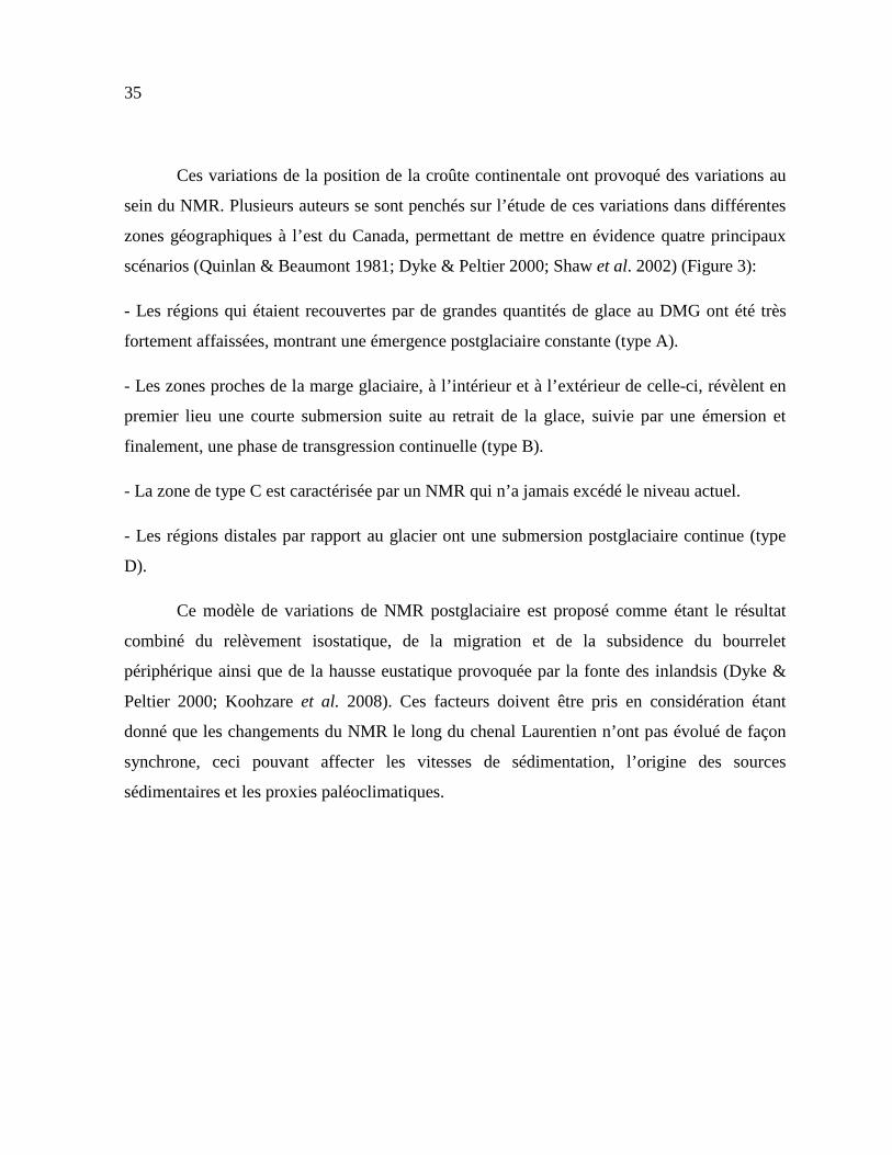
Figure 3. A. Représentation des quatre principaux scénarios (A, B, C et D) illustrant l’histoire des variations du NMR pour l’est du Canada et la côte nord-est des États-Unis, de 18 kyr BP (~21,7 ka cal BP) à nos jours. B. Illustration schématique de la position du bourrelet périphérique à 18 kyr BP et de nos jours. Le sens de migration du bourrelet est indiqué par la flèche et les différents points représentent la position des différents scénarios C. Démarcation théorique des différents scénarios (modifié de Quinlan & Beaumont 1981). ............................................................................................ 36
Figure 4. Différentes unités sismiques identifiées dans le chenal Laurentien (modifié de St-Onge et al. 2008) ......................................................................................................... 37
Figure 5. Carte géologique simplifiée illustrant les différentes provinces géologiques autour de l’EGSL (modifiée de Loring & Nota 1973). Les principales compositions minéralogiques et magnétiques des roches de la côte nord et de la rive sud sont spécifiées. ............................................................................................................................. 41
Figure 6. Illustration schématique des différentes masses d’eau qui circulent dans l’EGSL (modifié de Koutikonsky & Bugden, 1991). ........................................................... 43
Figure 7. Evolution temporelle de la température de l’eau de mer et de la saturation en oxygène à 300m de profondeur au niveau des masses d’eau proches de Rimouski (modifié de Gilbert et al. 2007). ........................................................................................... 45

xx
Figure 8. Diagramme 143Nd/144Nd en fonction du temps (en milliards d’années) pour le modèle CHUR (modifié de DePaolo & Wasserburg 1976).............................................. 48
Figure 9. Carte mondiale représentant l’hétérogénéité de la composition isotopique en Nd sur les différents continents (Jeandel et al. 2007)........................................................... 49
Figure 10. Schéma illustrant les principales sources de néodyme à l’océan (modifié de Frank 2002). ......................................................................................................................... 51
Figure 11. Composition isotopique en néodyme des masses d’eau de surface (<100 m). Les flèches représentent les courants de surface. La signature isotopique en Nd des continents est représentée par des contours colorés au niveau des marges. CC: Courant des Canaries; EGC: Courant Est Groenlandais; FC: Courant de Floride; GS: Gulf Stream; IC: Courant d'Irminger; LC: Courant du Labrador; NAC: Courant Nord-Atlantique; NC: Courant de Norvège; NEC: Courant nord équatorial; WGC: Courant Ouest Groenlandais (Lambelet et al. 2016). ......................................................................... 53
Figure 12. Spectre schématique de distribution des REEs dans A) la fraction détritique de sédiments marins (modifié de Gutjahr et al. 2007) B) la fraction authigénique de sédiments marins (modifié de Gutjahr et al. 2007), et C) des échantillons d’eau de mer (modifié de Jeandel et al. 2013). ................................................ 56
Figure 13. Localisation des échantillons sédimentaires de surface, des carottes sédimentaires et des différentes stations d’eau de mer analysés au cours de ce projet de recherche. ......................................................................................................................... 64
Figure 14. Illustration des différentes compositions minéralogiques obtenues dans les sédiments de surface des trois carottes sédimentaires (A) COR0602-36PC, (B) COR0503-CL05-37PC, et (C) COR0503-CL04-36PC. Les résultats obtenus sont exprimés en %. ..................................................................................................................... 68
Figure 15. (A) Simplified oceanic circulation models from the EGSL (modified from Galbraith et al. 2016) between October to December (black vectors) and April to June (blue vectors). (B) Simplified geological map of the land adjacent to the EGSL (modified from Loring et al. 1973) showing the location of the three sedimentary piston cores studied herein. .................................................................................................. 88
xxi
Figure 16. Age models for cores COR0602-36PC, COR0503-CL05-37PC and COR0503-CL04-36PC. Modified from Barletta et al. (2010). ............................................ 91
Figure 17. Biplots of the PC-1 versus PC-2 obtained from the log-centred transformation of the bulk mineralogical and geochemical data for cores COR0602-36PC (A) (B), COR0503-CL05-37PC (C) (D) and COR0503-CL04-36PC (E) (F). ........... 97
Figure 18. Mean grain size versus depth for cores COR0602-36PC, COR0503-CL05-37PC and COR0503-CL04-36PC. The grey and orange areas represent glaciomarine and postglacial sediments, respectively. The sediment texture is indicated to the right of each diagram. St-c = silty clays; C-st = clayey silts; St = silts; S-md = sandy muds. Modified from Barletta et al. (2010). ................................................................................... 98
Figure 19. End-member modelling analyses (EMMA) performed on the grain-size distribution of the detrital fraction of cores COR0602-36PC (A), COR0503-CL05-37PC (B) and COR0503-CL04-36PC (C). The grain-size distribution of the four first end-members accounts for more than 95% of the total variance. Four representative unmixed grain-size distributions as well as end-member scores (%) derived from EMMA are shown. ............................................................................................................. 100
Figure 20. Multiproxy analysis for core COR0602-36PC. A. Relative sea level variations at Sept-Iles (Shaw et al. 2002). B. Geochemical log-ratio Zn/Sr. C. Mineralogical ratio phyllosilicates/(plagioclase+K-feldspar). D. Grain-size end-members Log(EM2/EM1). E. Geochemical log-ratio Zr/Al. F. Pseudo S-ratio magnetic parameter. G. Magnetic susceptibility (klf). H. a* indicates sediment colour variations from green to red. I. Dolomite content variations. Note that, organic matter and biogenic carbonate were removed with peroxide (30%) and hydrochloric acid (0.5 N), respectively, before bulk mineralogical analysis. ................................................. 103
Figure 21. Multiproxy analysis for core COR0503-CL05-37PC. A. Relative sea level at the eastern New Brunswick (Shaw et al. 2002). B. Geochemical log-ratio Si/K. C. Mineralogical ratio phyllosilicates/(plagioclase+K-feldspar). D. Grain-size end-members Log(EM2/EM1). E. Geochemical ratio Zr/Al. F. Pseudo S-ratio magnetic parameter. G. Magnetic susceptibility (klf). H. a* indicates sediment colour variations from green to red. I. Dolomite content variations. Note that, organic matter and

xxii
biogenic carbonate were removed with peroxide (30%) and hydrochloric acid (0.5 N), respectively, before bulk mineralogical analysis. ............................................................... 104
Figure 22. Multiproxy analysis for sedimentary core COR0503-CL04-36PC. A. Relative sea level at Port au Port (Shaw et al. 2002). B. Geochemical log-ratio Zn/Sr. C. Mineralogical ratio phyllosilicates/(plagioclase+K-feldspar). D. Grain-size end-members Log(EM2/EM1). E. Geochemical log-ratio Zr/Al. F. Pseudo S-ratio magnetic parameter. G. Magnetic susceptibility (klf). H. a* indicates sediment colour variations from green to red. I. Dolomite content variations. Note that, organic matter and biogenic carbonate were removed with peroxide (30%) and hydrochloric acid (0.5 N), respectively, before bulk mineralogical analysis. ................................................. 105
Figure 23. Evolution of the relative sea level over the last 10 000 years (Shaw et al. 2002) represented on three different places from the Estuary and Gulf of St. Lawrence: Sept-Isles (A), New-Brunswick border (B) and Port au Port (C). Two zones described by Clark et al. (1978) have also been represented (the inset at the top left): Zone 1 had a relative sea level around 80 m higher at 10 cal. ka BP and progressively decreases until today; and Zones 1–2 (a transition zone) had a higher sea level followed by a lower relative sea level around 8 cal. ka BP, and a gradual re-increase in sea level after that. The positions of the three sedimentary cores studied here are also shown............................................................................................................. 110
Figure 24. Evolution of sedimentary dynamics between 10-8.5 cal. ka BP and since 8.5 cal. ka BP. During the early Holocene (A), the sedimentary dynamics is mainly controlled by the meltwater discharges due to the rapid retreat of the southeastern margin of the LIS on the North Shore (LIS position is schematic for the period from 10 to 9 cal. ka BP; Shaw et al. 2002). The sedimentary contribution of the Appalachians is induced by a high relative sea level in the estuary and by a low relative sea level in the gulf, causing a strong erosion of the Magdalen Shelf (modified from Shaw et al. 2002). From 8.5 cal. ka BP to the present (B), variations in relative sea level represent the predominant forces acting on the EGSL sedimentary dynamics. A sharp discrimination of sedimentary sources appears, with the North Shore becoming the main sediment supply in the estuary whereas the South Shore appears as the main sedimentary sources in the gulf. ......................................................... 118

xxiii
Figure 25. General map of the Estuary and Gulf of St. Lawrence representing the location of the different sediments in the core-tops and seawater stations studied herein. The continental geological provinces are illustrated according to Farmer et al. (2003) with the εNd signatures of Labrador Current Water (εNd = -15; Lacan and Jeandel 2004; Lacan et al. 2012) and North Atlantic Current Water (εNd = -11; Spivack and Wasserburg 1988; Lacan et al. 2012). A simplified model of sea surface circulation is schematized according to Galbraith et al. (2016). ........................................ 133
Figure 26. (A) Salinity versus potential temperature and (B) Salinity versus potential density obtained from the five seawater stations (COR1503-07, COR1207-007, COR1207-003, COR1206-025, and COR1206-030). ........................................................ 146
Figure 27. Distribution of (A) Nd concentrations, (B) Ce/Ce* (Ce/Ce* = 2[Ce]n /([La]n + [Pr]n), and (C) LREE/HREE ratio obtained from the five seawater stations. (D) Vertical distribution of suspended particulate matter from the Gulf (station 39; Sundby, 1974) and Estuary of St. Lawrence (station 38 from Yeats et al., 1979; stations F1 and EM4 from Neumeier, personal communication 2017). (E) Vertical distribution of the salinity obtained from the five seawater stations. ................................. 148
Figure 28. (A) REE patterns normalized to PAAS at the different depths of the five stations. (B) REE patterns normalized to PAAS for the leachate sediment samples. (C) REE patterns normalized to PAAS for the detrital sediment samples. ........................ 149
Figure 29. Vertical profiles of εNd values at the five seawater stations along a W-E salinity transect from the EGSL. ........................................................................................ 151
Figure 30. Spatial distribution of εNd obtained in the (A) leachate surface sediments and (B) detrital surface sediments. ..................................................................................... 152
Figure 31. εNd detritic vs εNd obtained on leachate sediment. The Appalachian area is composed by the surface sediments obtained on the cores COR0902-16BC, COR0503-CL03-35BC, 2003-033-030PC, COR1004-ECL-BC and COR1002-27B. The Grenville Province area is composed by the surface sediments obtained on the cores COR0503HONOI-14BC, COR1004-CE-BC, COR-0602-043-BC and COR0602-045BC. The Baffin Bay area is defined by the sediment sample MD99-2236. ................................................................................................................................... 153
xxiv
Figure 32. Comparison of HREE/LREE vs. MREE* crossplots (Du et al. 2016) obtained from seawater samples, and authigenic and detrital sediment samples. A mixing line between the most HREE-enriched oxic pore waters (Haley et al. 2004) and the most MREE-enriched leachates (Gutjahr et al. 2010) reflects the ‘‘authigenic-pore water array” (dashed line). ......................................................................................... 159
Figure 33. Relative contribution of Appalachian source vs. the North American Shield. The relative percentages were calculated with the Nd isotope composition from the North American Shield (143Nd/144Nd = 0.51105 ; Innocent et al. 1997) and Appalachian sources (143Nd/144Nd = 0.512045 ; Fagel and Hilaire Marcel 2006) according to 143Nd/144Nd(%Grenville-Prov)=[[( 143Nd/144Ndsample) – (0.512045-0.51105)]/ (0.512045-0.51105)]*100. .................................................................................................. 163
Figure 34. Comparison of detrital sediment sample sources with (A) εNd versus 87Sr/86Sr ratios (B) εNd versus La/Yb (C) La/Yb vs Gd/Yb. ............................................. 168
Figure 35. Simplified map of the continental geological provinces around the Estuary and Gulf of St. Lawrence (modified from Farmer et al. 2003). The locations of the sediment cores COR0602-36PC (estuary; blue star) and COR0503-CL04-36PC (gulf; red star) studied herein are indicated. The location of cores MD95-2033 (orange circle; Stevenson et al. 2008) and 91-045-094 (green circle; Fagel et al. 1999) are also shown. The εNd signatures of the Labrador Current Water (εNd = -15; Lacan and Jeandel 2004; Lacan et al. 2012) and North Atlantic Current Water (εNd = -11; Spivack and Wasserburg 1988; Lacan et al. 2012) are reported. A simplified model of sea surface circulation is schematized according to Galbraith et al. (2016). ..................... 193
Figure 36. Age models for cores COR0602-36PC and COR0503-CL04-36PC, modified from Barletta et al. (2010). The age–depth relationship was built with a Bayesian approach using the R-package Bacon (Blaauw and Christen 2011). The red dashed line shows the best age model and the black shading represents the chronological uncertainties (95% confidence interval). The green line shows the changes in sedimentation rates along depth. The light blue and light gray areas represent glaciomarine and postglacial sediments respectively. The sediment texture is indicated to the right of each diagram (modified from Barletta et al. 2010). St-c = silty clays; C-st = clayey silts; St = silts; S-md = sandy muds. .......................................... 197

xxv
Figure 37. REE patterns normalized to PAAS (Pourmand et al., 2012) for the bulk leachate sediment samples of (A) core COR0503-CL04-36PC (gulf) and (B) core COR0602-36PC (estuary)................................................................................................... 203
Figure 38. (A) Log(Al/Nd) ratio compared to the 87Sr/86Sr isotopic composition and (B) comparison of HREE/LREE vs. MREE* cross-plots (Du et al. 2016) obtained from the bulk sediment leachate of the sediment cores COR0602-36PC (estuary) and COR0503-CL04-36PC (gulf) and compared with detrital surface sediments, leachate surface sediment and seawater samples from Casse et al. under review. .......................... 207
Figure 39. Relationship between ɛNd (this study) and (A) Log(EM2/EM1), (B) Phy/(Plg+Kfs), (C) Log(Zn/Sr) ratios for the sediment cores COR0602-36PC (estuary) and COR0503-CL04-36PC (gulf) obtained by Casse et al. (2017). The sediment samples are differentiated according to their age. ............................................... 210
Figure 40. Comparison of Nd isotopic evolution of the cores COR0602-36PC (estuary) and COR0503-CL04-36PC (gulf), studied here, and cores MD95-2033 and 91-045-094, studied by Stevenson et al. (2008) and Fagel et al. (1999) respectively. ...... 213
Figure 41. Multiproxy analysis for core COR0602-36PC and core COR0503-CL05-37PC illustrating the evolution of sedimentary dynamics between 10–8 cal. ka BP and since 8 cal. ka BP. The relative sea level variations, Log(Zn/Sr), Phy/(Plg+Kfs), Eu/Eu*, HREE/LREE and ɛNd are compared for each sediment core during the Holocene. During the early Holocene, the meltwater discharges induced by the rapid retreat of the LIS on the North Shore appear to be the predominant force acting on the sedimentation (LIS position is schematic for the period from 10 to 9 cal. ka BP; Shaw et al. 2002). Beyond 8 cal. ka BP, the sediment dynamic is mainly controlled by variations in the relative sea level....................................................................................... 215
Figure 42. Relationship between Phy/(Plg+Kfs) and (Eu/Eu*)n for the sediment cores COR0602-36PC (estuary) and COR0503-CL04-36PC (gulf). The sediment samples are differentiated according to their age. ............................................................................ 218
Figure 43. Illustration shématique de la dynamique sédimentaire entre 10 et 8,5 ka cal BP. La fonte de l’inlandsis laurentidien agit comme le forçage principal sur le transport des sédiments au début de l’Holocène. Les tres faibles valeurs eNd enregistrées dans les sédiments et les taux de sédimentation importants enregistrés au
xxvi
début de l’Holocène témoignent du retrait de la calotte de glace LIS sur la Côte Nord. Les données minéralogiques et géochimiques obtenues sur les carottes sédimentaires prélevées au fond du chenal Laurentien témoignent d’un mélange sédimentaire entre les roches provenant de la côte nord et celles issues de la chaine des Appalaches. La sédimentation essentiellement dominée par des sédiments argileux indique un environnement glacio-marin distal. .................................................................................... 235
Figure 44. Illustration shématique de la dynamique sédimentaire entre 8,5 ka cal BP et l’actuel. Les variations du NMR agissent comme le forçage principal sur la dynamique sédimentaire dans l’EGSL. Les valeurs εNd plus radiogéniques enregistrées dans les sédiments et la chute du taux de sédimentation montrent que le retrait de la calotte de glace LIS n’exerce plus de contrôle significatif sur le transport sédimentaire dans l’EGSL. Les données minéralogiques et géochimiques obtenues sur les carottes sédimentaires prélevées au fond du chenal Laurentien montrent une discrimination des principales sources sédimentaires entre l’estuaire et le golfe. L’apparition d’une sédimentation plus grossiere dominée par les silts témoigne de l’installation des conditions océanographiques actuelles avec la mise en place du courant de Gaspé. ............................................................................................................... 236
Figure 45. Carte représentant les proportions relatives des argiles des différents échantillons (Thoby 2014). ................................................................................................. 241
Figure 46. Identification des sources continentales potentielles de Pb à partir des ratios isotopiques 208Pb/204Pb vs 206Pb/204Pb (modifié de Foster & Vance 2006). ............. 249
Figure 47. Comparaison des rapports isotopiques εNd et εHf dans différents réservoirs terrestres. La compilation des données obtenue a partir de roches mantelliques, de la croute continentale ainsi que sur des encroutements de fer et de manganèse et sur des échantillons d’eau de mer a permis de mettre en évidence une zone « eau de mer » et une « zone terrestre » (Godfrey et al. 1997 ; Vervoort et al. 1999 ; Albarède et al. 1998 ; David et al. 2001 ; Frank et al. 2002). ................................. 251
Figure 48. Comparison of magnetic susceptibility profiles of cores MD99-2221 and COR0602-36PC. Correlative magnetic features are indicated. The last age-depth point of core MD99-2221 was used in the age model of core COR0602-36PC. ............... 254
xxvii
Figure 49. Vertical distribution of the bulk mineralogical and geochemical data obtained on the sedimentary cores COR0503-CL04-36PC (A-B), COR0503-CL05-37PC (C-D) and COR0602-36PC (E-F). ............................................................................ 255

LISTE DES ABRÉVIATIONS, DES SIGLES ET DES ACRONYMES
BP Before present, avant le présent
Cal Calibrated dates, âges calibrés Ce Cerium
CHUR Chondritic Uniform Reservoir, réservoir uniforme chondritique
DMG Dernier Maximum Glaciaire
ETR Éléments des terres rares
EGSL Estuaire et Golfe du Saint-Laurent
Eu Europium
GEOTOP Centre de recherche en Géochimie isotopique et en Géochronologie
HREE Heavy Rare Earth Element, éléments des terres rares lourdes IML Institut Maurice-Lamontagne ISMER Institut des sciences de la mer de Rimouski
Kfs Feldspaths potassiques
LC Labrador Current, courant du Labrador LIS Laurentide Ice Sheet, inlandsis Laurentidien LREE Light Rare Earth Element, éléments des terres rares légères

xxix
MREE Medium Rare Earth Element, éléments des terres rares moyens MSCL Multi Sensor Core Logger NACW North Atlantic Current Water, courant nord Atlantique NMR Niveau marin relatif Nd Néodyme PAAS Post Archaean Australian Shale, schiste australien post-archéen Phy Phyllosilicates Plg Plagioclases REE Rare Earth Element, éléments des terres rares SPM Suspended particulate matter Sr Strontium UQAR Université du Québec à Rimouski

LISTE DES SYMBOLES
α Alpha
ε Epsilon
µ Mu ka Milliers d’années Å Ångström
θ Thêta

INTRODUCTION GÉNÉRALE
L’introduction générale de cette thèse présente la problématique globale du projet de
recherche dans un contexte sédimentologique, paléoenvironnementale et paléoclimatique.
Dans un premier temps, l’environnement postglaciaire présent au début de l’Holocène au
niveau de l’estuaire et du golfe du Saint-Laurent (EGSL) ainsi que les variations du niveau
marin relatif (NMR) subséquentes à la déglaciation seront remis en contexte de façon à
comprendre les grandes caractéristiques climatiques et océanographiques qui initient notre
étude. Dans un second temps, les travaux antérieurs faisant part de l’état des lieux des
sédiments d’un point de vue granulométrique, minéralogique et géochimique ainsi que les
grands traits de la circulation estuarienne seront énoncés. De plus, il sera discuté du potentiel
des isotopes du néodyme (Nd) pour mener des études paléoclimatiques. L’objectif général de
cette thèse sera articulé au travers de trois objectifs spécifiques qui seront énumérés et
discutés autour des principales questions de recherche. Enfin, la méthodologie utilisée pour
répondre aux différents objectifs sera exposée. Cette introduction générale sera suivie par la
présentation détaillée des trois chapitres de la thèse, exposant les réalisations majeures de
l’auteure au cours du projet de recherche.

32
INTRODUCTION À LA PROBLÉMATIQUE
CONTEXTE POSTGLACIAIRE ET VARIATIONS DU NIVEAU MARIN
RELATIF
L’EGSL forme un environnement de transition entre les eaux marines provenant du nord-
ouest de l’océan Atlantique et les eaux douces s’écoulant des bassins versants des Grands
Lacs et du fleuve Saint-Laurent. Le fleuve Saint-Laurent possède un bassin de drainage
d'environ 1.3 × 10⁶ km2 et, en ce qui concerne le ruissellement d'eau douce dans l'océan
Atlantique Nord, sa décharge est la deuxième plus grande en Amérique du Nord après la
rivière Mississippi (Bourgault & Koutitonsky 1999). La dynamique océanographique et
sédimentaire dans cette région est fortement influencée par les changements hydrologiques au
sein du bassin versant du Saint-Laurent, ainsi que par la variabilité climatique et
océanographique dans le nord-ouest de l’océan Atlantique (Bugden 1991; Drinkwater &
Gilbert 2004; Gilbert et al. 2005, 2007; Gamboa et al. 2010). La bathymétrie de l’EGSL est
principalement caractérisée par le chenal Laurentien, une vallée sous-marine en forme de
« U », qui est le produit de l’action érosive de courants glaciaires lors des glaciations
quaternaires (Piper et al. 1990; St-Onge et al. 2011). Ce chenal varie entre 250 et 500m de
profondeur et s’étend du plateau continental est canadien jusqu’aux environs de Tadoussac
(St-Onge et al. 2011). Dans la partie nord-est du golfe, le chenal Anticosti et le chenal
Esquiman forment également deux vallées sous-marines en forme de « U » d'origine glaciaire
(Figure 1).

33
Figure 1. Bathymétrie de l’EGSL (modifié de Shaw et al. 2006). Les principaux chenaux et détroits sont spécifiés.
La morphologie générale et les paysages autour de l’EGSL ont été fortement
influencés par le dernier maximum glaciaire (DMG) il y a environ 21000 ans, lorsque les
calottes de glace ont atteint leur volume maximal (Mix et al. 2001). La calotte de glace
Laurentienne (LIS), qui couvrait des millions de kilomètres carrés, s’étendait il y a 21000 ans
sur la majeure partie du Canada et des États-Unis. Selon Stea et al. (2004), les provinces à
l’est du Canada étaient entièrement couvertes de glace lors du DMG. En effet, les calottes de
glace recouvraient toute la vallée du Saint-Laurent pour s’étendre plus à l’est au niveau des
provinces maritimes ainsi qu’au sud de la Nouvelle-Angleterre (Dyke 2004). Cette très grande
quantité de glace sur le continent Nord Américain a fortement modifié son environnement,
notamment en provoquant des variations de la position de la croûte continentale. Selon
34
Koohzare et al. (2008), les dômes de glace présents à la surface du continent ont crée un
enfoncement de la croûte terrestre, et le matériel mantellique sous-jacent a migré vers les
régions circonvoisines, créant ainsi un bourrelet périphérique. Le réchauffement postglaciaire,
principalement contrôlé par des modifications de l’insolation liées aux irrégularités de l’orbite
terrestre, a provoqué la fonte de la LIS dans l’hémisphère nord, entrainant différentes phases
d’évolution de la position de la croûte continentale dans les régions du Saint-Laurent. Ainsi,
lorsque les calottes glaciaires fondent, le bourrelet périphérique migre en direction des
glaciers en récession, c’est-à-dire vers les régions autrefois prises par la glace (Figure 2). De
cette façon, les régions surélevées par la présence du bourrelet périphérique au cours du DMG
sont en subsidence pendant la déglaciation, alors que les zones enfoncées par le poids des
glaciers sont en surrection (on parle alors de rebond post-isostatique).
Figure 2. A. Enfoncement glacio-isostatique de la lithosphère et formation du bourrelet périphérique en bordure du glacier. B. Ajustement glacio-isostatique dû au rebond postglaciaire de la croûte terrestre et à la migration éventuelle du bourrelet périphérique (modifié de Oakley & Boothroyd 2012).
35
Ces variations de la position de la croûte continentale ont provoqué des variations au
sein du NMR. Plusieurs auteurs se sont penchés sur l’étude de ces variations dans différentes
zones géographiques à l’est du Canada, permettant de mettre en évidence quatre principaux
scénarios (Quinlan & Beaumont 1981; Dyke & Peltier 2000; Shaw et al. 2002) (Figure 3):
- Les régions qui étaient recouvertes par de grandes quantités de glace au DMG ont été très
fortement affaissées, montrant une émergence postglaciaire constante (type A).
- Les zones proches de la marge glaciaire, à l’intérieur et à l’extérieur de celle-ci, révèlent en
premier lieu une courte submersion suite au retrait de la glace, suivie par une émersion et
finalement, une phase de transgression continuelle (type B).
- La zone de type C est caractérisée par un NMR qui n’a jamais excédé le niveau actuel.
- Les régions distales par rapport au glacier ont une submersion postglaciaire continue (type
D).
Ce modèle de variations de NMR postglaciaire est proposé comme étant le résultat
combiné du relèvement isostatique, de la migration et de la subsidence du bourrelet
périphérique ainsi que de la hausse eustatique provoquée par la fonte des inlandsis (Dyke &
Peltier 2000; Koohzare et al. 2008). Ces facteurs doivent être pris en considération étant
donné que les changements du NMR le long du chenal Laurentien n’ont pas évolué de façon
synchrone, ceci pouvant affecter les vitesses de sédimentation, l’origine des sources
sédimentaires et les proxies paléoclimatiques.

36
Figure 3. A. Représentation des quatre principaux scénarios (A, B, C et D) illustrant l’histoire des variations du NMR pour l’est du Canada et la côte nord-est des États-Unis, de 18 kyr BP (~21,7 ka cal BP) à nos jours. B. Illustration schématique de la position du bourrelet périphérique à 18 kyr BP et de nos jours. Le sens de migration du bourrelet est indiqué par la flèche et les différents points représentent la position des différents scénarios C. Démarcation théorique des différents scénarios (modifié de Quinlan & Beaumont 1981).
37
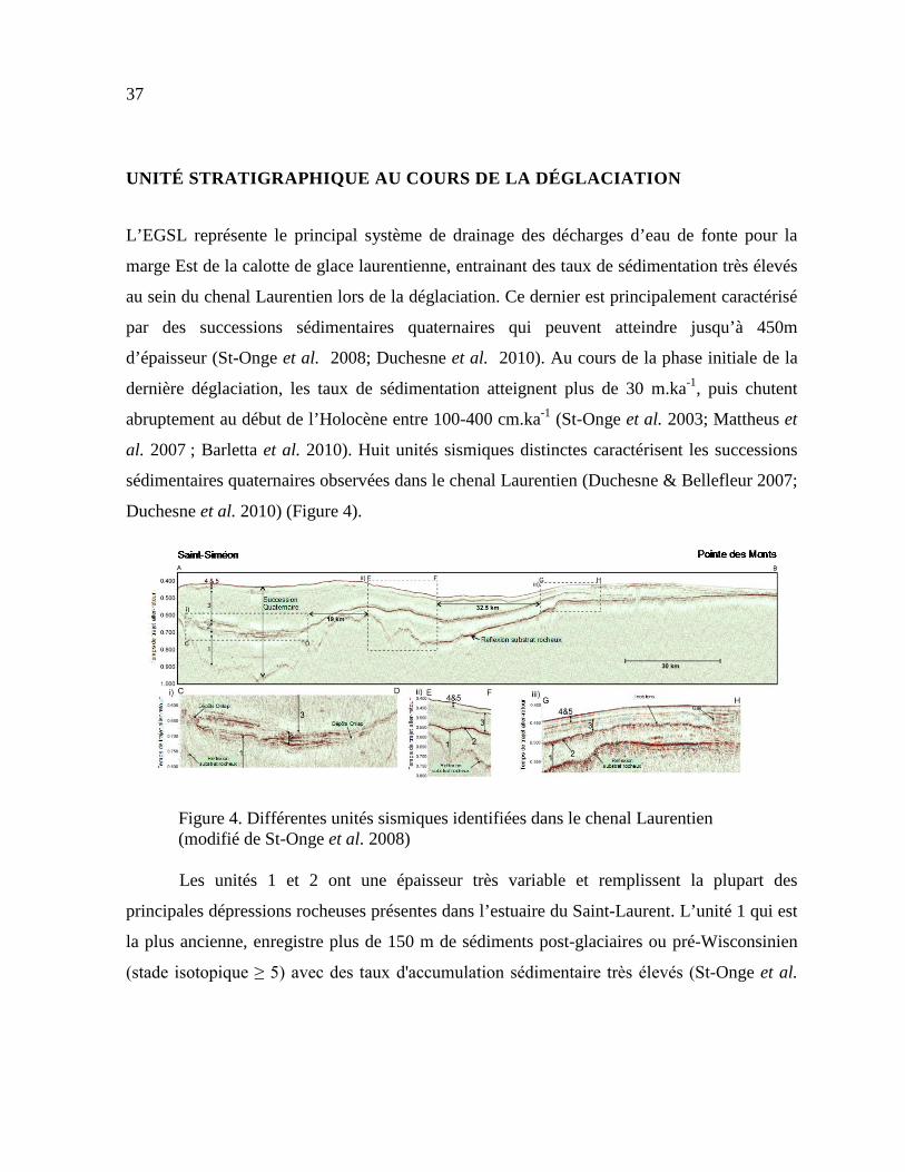
UNITÉ STRATIGRAPHIQUE AU COURS DE LA DÉGLACIATION
L’EGSL représente le principal système de drainage des décharges d’eau de fonte pour la
marge Est de la calotte de glace laurentienne, entrainant des taux de sédimentation très élevés
au sein du chenal Laurentien lors de la déglaciation. Ce dernier est principalement caractérisé
par des successions sédimentaires quaternaires qui peuvent atteindre jusqu’à 450m
d’épaisseur (St-Onge et al. 2008; Duchesne et al. 2010). Au cours de la phase initiale de la
dernière déglaciation, les taux de sédimentation atteignent plus de 30 m.ka-1, puis chutent
abruptement au début de l’Holocène entre 100-400 cm.ka-1 (St-Onge et al. 2003; Mattheus et
al. 2007 ; Barletta et al. 2010). Huit unités sismiques distinctes caractérisent les successions
sédimentaires quaternaires observées dans le chenal Laurentien (Duchesne & Bellefleur 2007;
Duchesne et al. 2010) (Figure 4).
Figure 4. Différentes unités sismiques identifiées dans le chenal Laurentien (modifié de St-Onge et al. 2008)
Les unités 1 et 2 ont une épaisseur très variable et remplissent la plupart des
principales dépressions rocheuses présentes dans l’estuaire du Saint-Laurent. L’unité 1 qui est
la plus ancienne, enregistre plus de 150 m de sédiments post-glaciaires ou pré-Wisconsinien
(stade isotopique ≥ 5) avec des taux d'accumulation sédimentaire très élevés (St-Onge et al.
38
2008). L’unité 2 enregistre près de 68m de dépôts sédimentaires et s’est déposée pendant une
phase de stabilisation marquée par des avancées locales de la calotte glaciaire Laurentidienne
au niveau de la mer de Goldthwait avant – ou pendant le Dryas récent. Cette unité est
recouverte par une séquence sédimentaire très épaisse atteignant 250 m de dépôts dans
l'estuaire du Saint-Laurent (St-Onge et al. 2008). L’unité 3 est présente sur l'ensemble de la
partie inférieure de l'estuaire du Saint-Laurent et remplit partiellement des bassins trouvés en
bordure du plateau le long de l’estuaire. Elle est essentiellement composée de dépôts argileux
glacio-marins (≥ 8,5 cal. ka BP). Les unités 4 et 5, associées à des sédiments postglaciaires (≤
8,5 cal. ka BP; St-Onge et al. 2003) ont une épaisseur de sédiments constante, ce qui suggère
qu'elles ont été déposées dans des conditions hémipélagiques. Les unités 6, 7 et 8 ont été
déposées par des processus sédimentaires locaux associés à des mouvements de masses, des
deltas sous-marins ainsi que des courants de contour le long des flancs du chenal Laurentien.
Les profils sismiques de haute résolution obtenus dans l’EGSL sont en corrélation avec les
faciès sédimentaires observés dans les carottes de sédiments indiquant que les tills, les
sédiments glacio-marins et les dépôts argileux postglaciaires caractérisent la stratigraphie
régionale de l’EGSL entre la fin du Pléistocène et l’Holocène (e.g. Loring & Nota 1973;
Josenhans & Lehman 1999; Duchesne et al. 2010; St-Onge et al. 2011).
NATURE ET ORIGINE DES SÉDIMENTS
Les sédiments de surface dans l’EGSL sont caractérisés par des sédiments fins (notamment
des silts fins) dans la partie centrale du chenal Laurentien, et par des sédiments plus grossiers
(des graviers, du sable, et en moindre proportion des silts fins) au niveau de la pente et des
plateaux adjacents (Loring & Nota 1973; St-Onge et al. 2003; Pinet et al. 2011; Jaegle
2015). La matière particulaire en suspension présente dans la colonne d’eau de l’EGSL est
majoritairement d’origine détritique (60 à 90 %) et la taille moyenne des grains est très fine,
généralement comprise entre 5 et 7 µm (D’Anglejan & Smith 1973; Barletta et al. 2010; Pinet

39
et al. 2011). Actuellement, les taux de sédimentation varient entre 0,70 cm.an-1 dans la partie
estuarienne du chenal laurentien et 0.04 cm.an-1 dans le golfe (Smith & Schafer 1999). Dans
cette région, la sédimentation détritique est influencée par des variations saisonnières au sein
des précipitations de pluie ou de neige, par les décharges d’eau douce amenées par les
rivières, par la circulation atmosphérique, par les courants de marée, par l’énergie des vagues
et par la formation de glace de mer (D’Anglejan & Smith 1973; Dionne 1993; Saucier et al.
2003; Hargrave et al. 2007; Scully & Friedrichs 2007). En raison des taux de sédimentation
très élevés dans le chenal Laurentien, les séquences sédimentaires déposées au fond du chenal
représentent des enregistrements exceptionnels pour reconstituer les changements de
provenance du matériel terrigène, les mécanismes du transport sédimentaire, la dynamique
sédimentaire et les conditions climatiques passées de l’EGSL. Cependant, la nature, l’origine
et le transport des sédiments détritiques dans l’EGSL ainsi que la variabilité sédimentaire au
cours du temps sont jusqu’à présent très peu documentés (D’Anglejan 1969; D’Anglejan &
Smith 1973; Pinet et al. 2011). Les signatures minéralogiques, géochimiques et magnétiques
des sédiments terrigènes transportés par les rivières de la Côte-Nord et de la Côte-Sud vers
l’EGSL sont spécifiques aux différentes provinces géologiques réparties de part et d’autre du
Saint-Laurent (Loring & Nota 1973; Jaegle 2015). Les apports sédimentaires dans l’EGSL
sont principalement issus de l’érosion et de l’altération des roches métamorphiques de la
province de Grenville sur la Côte-Nord ainsi que des roches sédimentaires paléozoïques de la
chaine des Appalaches sur la Côte-Sud, des provinces maritimes et de la Côte-Ouest de Terre
Neuve (Loring & Nota 1973; Jaegle 2015). Ces provinces géologiques ont des signatures
minéralogiques, géochimiques et magnétiques distinctes (Loring & Nota 1973; Jaegle 2015)
(Figure 5):
- Les roches métamorphiques et ignées de la province de Grenville composant le bouclier
canadien sur la Côte-Nord présentent un enrichissement en amphiboles, feldspaths
potassiques, plagioclases, et des couches mixtes d’illite et de smectite. Elles sont fortement
enrichies en magnétite et ont une forte susceptibilité magnétique (Klf proche de 1).
40
- Les roches sédimentaires paléozoïques de la chaine des Appalaches sur la Côte-Sud sont
caractérisées par un enrichissement en quartz et phyllosilicates (notamment en illite et
chlorite). Elles sont enrichies en hématite et ont une faible susceptibilité magnétique.
D’autre part, les roches sédimentaires paléozoïques (incluant le calcaire et la dolomite)
qui affleurent à la surface de l’île d’Anticosti et sur la Côte-Ouest de Terre-Neuve
représentent également des sources locales de sédiments vers le golfe du Saint-Laurent
(Loring & Nota 1973; Ebbestad & Tapanila 2005). Avec un taux d’altération des carbonates
d’environ 89% par rapport aux silicates, l’altération et la dissolution des carbonates représente
un processus chimique majeur dans l’EGSL (Gaillardet et al., 1999; Yang et al., 1996). Il est
donc important de prendre en considération que les sources d’éléments chimiques tels que le
Ca ou le Sr peuvent être fortement liées aux carbonates détritiques présents sur les continents
adjacents (dans les calcaires et dolomites).
Les variations au sein de la composition minéralogique, géochimique et magnétique
des sédiments prélevés dans le chenal Laurentien peuvent être attribuées à des changements
de contribution relative des différentes sources sédimentaires au cours du temps.

41
Figure 5. Carte géologique simplifiée illustrant les différentes provinces géologiques autour de l’EGSL (modifiée de Loring & Nota 1973). Les principales compositions minéralogiques et magnétiques des roches de la côte nord et de la rive sud sont spécifiées.
CIRCULATION ESTUARIENNE
Les particules sédimentaires présentes dans l’EGSL sont essentiellement acheminées par les
rivières qui transportent du matériel issu de l’érosion et de l’altération des différentes roches
continentales avoisinantes. Cependant, le fleuve Saint-Laurent est parmi les environnements

42
qui transportent des quantités de sédiments très faibles par km2 par rapport à sa superficie
totale de drainage (Loring & Nota 1973). Ceci est dû en partie à la présence des Grands Lacs
qui forment d’énormes bassins de décantation, ainsi qu’à la morphologie générale du bassin
de drainage (Holeman 1968). L’EGSL est caractérisé par une circulation estuarienne avec des
eaux douces provenant des rivières qui s’écoulent en surface en direction de l’océan
Atlantique, et des eaux intermédiaires et profondes plus salées qui circulent vers l’estuaire
(Koutitonsky & Bugden 1991) (Figure 6). Cet environnement représente un système estuarien
unique, notamment en raison de sa position géographique comprise entre 47°N et 50°N lui
valant des caractéristiques typiques d’un environnement subpolaire. Par exemple, la couche
de surface enregistre de larges contrastes saisonniers en raison des variations de températures
atmosphériques très importantes dans les masses d’air sus-jacentes. Ainsi, les eaux de surface
gèlent en hiver puis atteignent jusqu’à 18°C au printemps, lorsque les conditions climatiques
atmosphériques deviennent plus clémentes (De Vernal et al. 2011). Au cours de la majeure
partie de l'année, la colonne d'eau de l’EGSL est fortement stratifiée et caractérisée par trois
couches distinctes (Dickie & Trites 1983; El-Sabh & Silverberg 1990; Bugden 1991; Gilbert
& Pettigrew 1997; Gilbert et al. 2005; Galbraith 2006; Thibodeau et al. 2010, 2013) (Figure
6):
- En surface (jusqu’à 50m de profondeur), les masses d’eau douce qui s’écoulent de l’estuaire
en direction de l’embouchure ont une température comprise entre 2°C et 10°C et une salinité
variant de 25 à 32 ‰. Elles sont le résultat du mélange des eaux salées originaires de l’océan
Atlantique avec les eaux douces provenant des Grands Lacs, de la rivière Saint-Laurent ainsi
que du drainage de l’ensemble du bassin versant de la Côte-Nord.
- La couche d’eau intermédiaire qui circule entre 50 et 150m de profondeur a une température
qui varie entre -1°C et 2°C et une salinité comprise entre 31,5 et 33 ‰. Cette couche d’eau
froide est représentative des conditions hivernales de l’année précédente. En effet, en hiver,
les eaux de surface sont gelées et l’EGSL est constitué de seulement deux couches océaniques
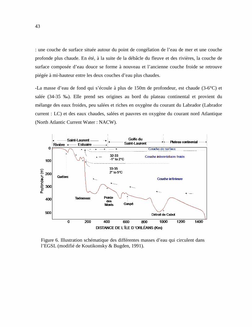
43
: une couche de surface située autour du point de congélation de l’eau de mer et une couche
profonde plus chaude. En été, à la suite de la débâcle du fleuve et des rivières, la couche de
surface composée d’eau douce se forme à nouveau et l’ancienne couche froide se retrouve
piégée à mi-hauteur entre les deux couches d’eau plus chaudes.
-La masse d’eau de fond qui s’écoule à plus de 150m de profondeur, est chaude (3-6°C) et
salée (34-35 ‰). Elle prend ses origines au bord du plateau continental et provient du
mélange des eaux froides, peu salées et riches en oxygène du courant du Labrador (Labrador
current : LC) et des eaux chaudes, salées et pauvres en oxygène du courant nord Atlantique
(North Atlantic Current Water : NACW).
Figure 6. Illustration schématique des différentes masses d’eau qui circulent dans l’EGSL (modifié de Koutikonsky & Bugden, 1991).
44
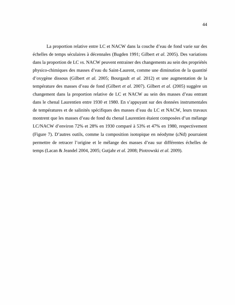
La proportion relative entre LC et NACW dans la couche d’eau de fond varie sur des
échelles de temps séculaires à décennales (Bugden 1991; Gilbert et al. 2005). Des variations
dans la proportion de LC vs. NACW peuvent entrainer des changements au sein des propriétés
physico-chimiques des masses d’eau du Saint-Laurent, comme une diminution de la quantité
d’oxygène dissous (Gilbert et al. 2005; Bourgault et al. 2012) et une augmentation de la
température des masses d’eau de fond (Gilbert et al. 2007). Gilbert et al. (2005) suggère un
changement dans la proportion relative de LC et NACW au sein des masses d’eau entrant
dans le chenal Laurentien entre 1930 et 1980. En s’appuyant sur des données instrumentales
de températures et de salinités spécifiques des masses d’eau du LC et NACW, leurs travaux
montrent que les masses d’eau de fond du chenal Laurentien étaient composées d’un mélange
LC/NACW d’environ 72% et 28% en 1930 comparé à 53% et 47% en 1980, respectivement
(Figure 7). D’autres outils, comme la composition isotopique en néodyme (εNd) pourraient
permettre de retracer l’origine et le mélange des masses d’eau sur différentes échelles de
temps (Lacan & Jeandel 2004, 2005; Gutjahr et al. 2008; Piotrowski et al. 2009).

45
Figure 7. Evolution temporelle de la température de l’eau de mer et de la saturation en oxygène à 300m de profondeur au niveau des masses d’eau proches de Rimouski (modifié de Gilbert et al. 2007).
GÉNÉRALITÉ SUR LA COMPOSITION ISOTOPIQUE EN NÉODYME DES DIFFÉRENTES ROCHES À LA SURFACE DE LA TERRE
Le néodyme est un élément chimique (numéro atomique : 60; symbole : Nd) qui appartient au
groupe des terres rares (Rare Earth Elements, REEs ou lanthanides). Le Nd existe sous la
forme de sept isotopes différents : 142Nd, 143Nd, 144Nd, 145Nd, 146Nd, 148Nd, 150Nd. Tous ces
isotopes sont stables dans la nature et deux possèdent une demi-vie très longue : 144Nd et 150Nd. Les autres isotopes (142Nd, 143Nd, 145Nd, 146Nd, 148Nd) ont une demi-vie très courte et
ont donc des abondances dans la nature négligeables. L’isotope 143Nd est dit radiogénique
46
(élément fil) car il provient de la désintégration de type alpha (α) du samarium (147Sm) qui est
radioactif (élément père). Ainsi, l’abondance relative du 143Nd par rapport aux autres isotopes
du Nd peut varier dans les différents réservoirs de la planète. L’équation de désintégration
pour le couple 147Sm et 143Nd est la suivante (Équation 1) :
𝑁𝑁 143 = 𝑁𝑁
143 0 + 𝑆𝑆 147 (𝑒𝜆𝜆 − 1)
Équation 1. L’équation de désintégration de l’élément chimique 147Sm en 143Nd, avec λ correspondant à la constante de désintégration (λ = 6,54 10-12 an-1).
Dans un système fermé, l’évolution au cours du temps de l’abondance de l’isotope 143Nd est normalisée par rapport à l’isotope 144Nd (Équation 2).
𝑁𝑁 143
𝑁𝑁 144 =
𝑁𝑁 143 0
𝑁𝑁 144 +
𝑆𝑆 147
𝑁𝑁 144 (𝑒𝜆𝜆 − 1)
Équation 2. Évolution des isotopes 143Nd et 144Nd au cours du temps, avec (143Nd/144Nd) correspondant à la quantité de 143Nd mesuré, (143Nd0/144Nd) équivalent à la quantité de 143Nd initial, et (147Sm/144Nd) à la quantité de 147Sm mesurée.
Lors des processus de différenciation des enveloppes terrestres il y a 3,5 Ga, les
discriminations chimiques entre la croûte continentale et le manteau ont induit des
hétérogénéités importantes au sein des traceurs isotopiques. Le néodyme a un comportement
incompatible par rapport au samarium, c’est-à-dire qu’il va migrer de façon préférentielle
dans la phase liquide (le magma) lors des processus de fusion partielle. Ainsi, le rapport 147Sm/144Nd de la croûte continentale est plus faible que celui du manteau. D’une manière
générale, les roches granitiques sont enrichies en terres rares légères (LREEs) et présentent un
rapport 143Nd/144Nd faible alors que les roches mantelliques, mafiques et ultra-mafiques
présentent un appauvrissement en LREEs avec un rapport 143Nd/144Nd plus élevé. De plus, les

47
rapports 143Nd/144Nd du réservoir mantellique et de la croûte continentale augmentent avec le
temps par production de 143Nd. De ce fait, les rapports isotopiques 143Nd/144Nd enregistrés
dans les différentes roches à la surface de la terre sont caractérisés par des valeurs très
différentes en fonction de l’âge et de l’histoire géologique de la roche. Cependant, la période
de désintégration du 147Sm en 143Nd est suffisamment longue (λ = 6,54 10-12 an-1) pour que
l’augmentation de l’isotope 143Nd soit négligeable à l’échelle du fonctionnement actuel de
l’océan. Compte tenu de la très faible différence entre les rapports 143Nd/144Nd (variations de
l’ordre de 10-4 à 10-5), le ratio est communément exprimé sous la forme εNd qui correspond à
une normalisation des rapports 143Nd/144Nd obtenus sur des chondrites (CHUR : Chondritic
Uniform Reservoir) qui sont des roches considérées comme des exemples du matériel
primordial du système solaire (Équation 3). Ainsi, ce modèle CHUR symbolise l’évolution
isotopique d’un système qui a préservé son caractère isolé depuis la formation du système
solaire (Figure 8). De cette façon, il est plus facile de repérer les variations de la composition
isotopique en Nd dans les différents compartiments terrestres.

48
Figure 8. Diagramme 143Nd/144Nd en fonction du temps (en milliards d’années) pour le modèle CHUR (modifié de DePaolo & Wasserburg 1976).
Le rapport εNd s’exprime selon l’équation (DePaolo & Wasserburg 1976):
𝜀𝑁𝑁 = [( 𝑁𝑁 143
𝑁𝑁 144 )é𝑐ℎ𝑎𝑎𝜆𝑎𝑎𝑎𝑎𝑎
( 𝑁𝑁 143
𝑁𝑁 144 )𝐶𝐶𝐶𝐶
− 1] × 10000
Équation 3. Expression du ratio εNd.
Où (143Nd/144Nd)échantillon représente le rapport isotopique mesuré dans l’échantillon et
(143Nd/144Nd)CHUR représente le rapport isotopique du CHUR à l’actuel = 0,512638 (Jacobsen
& Wasserburg 1980). La composition isotopique εNd enregistre des valeurs hétérogènes à la
surface de la planète, variant de εNd = -56 dans les vieux cratons granitiques jusqu’à εNd =
+12 dans les basaltes récents d’origine mantellique (Goldstein & Hemming 2003). Jeandel et
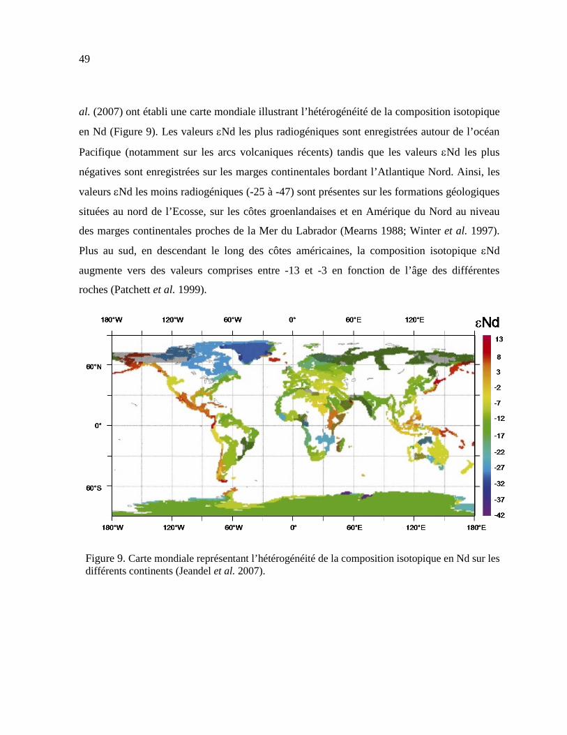
49
al. (2007) ont établi une carte mondiale illustrant l’hétérogénéité de la composition isotopique
en Nd (Figure 9). Les valeurs εNd les plus radiogéniques sont enregistrées autour de l’océan
Pacifique (notamment sur les arcs volcaniques récents) tandis que les valeurs εNd les plus
négatives sont enregistrées sur les marges continentales bordant l’Atlantique Nord. Ainsi, les
valeurs εNd les moins radiogéniques (-25 à -47) sont présentes sur les formations géologiques
situées au nord de l’Ecosse, sur les côtes groenlandaises et en Amérique du Nord au niveau
des marges continentales proches de la Mer du Labrador (Mearns 1988; Winter et al. 1997).
Plus au sud, en descendant le long des côtes américaines, la composition isotopique εNd
augmente vers des valeurs comprises entre -13 et -3 en fonction de l’âge des différentes
roches (Patchett et al. 1999).
Figure 9. Carte mondiale représentant l’hétérogénéité de la composition isotopique en Nd sur les différents continents (Jeandel et al. 2007).
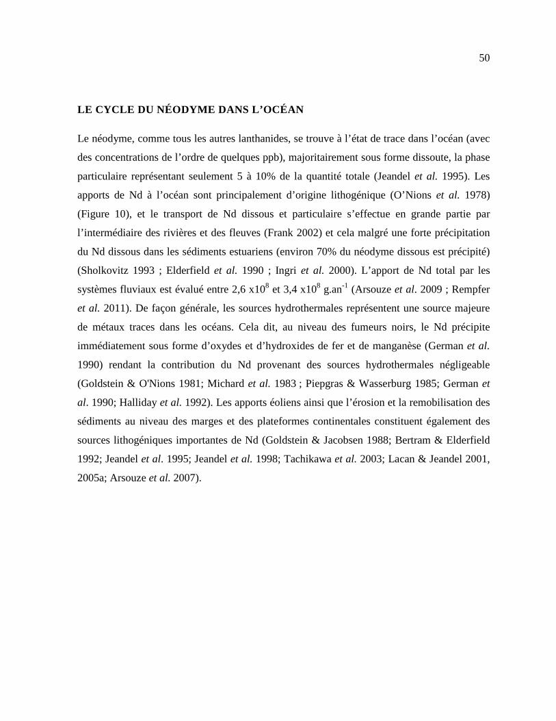
50
LE CYCLE DU NÉODYME DANS L’OCÉAN
Le néodyme, comme tous les autres lanthanides, se trouve à l’état de trace dans l’océan (avec
des concentrations de l’ordre de quelques ppb), majoritairement sous forme dissoute, la phase
particulaire représentant seulement 5 à 10% de la quantité totale (Jeandel et al. 1995). Les
apports de Nd à l’océan sont principalement d’origine lithogénique (O’Nions et al. 1978)
(Figure 10), et le transport de Nd dissous et particulaire s’effectue en grande partie par
l’intermédiaire des rivières et des fleuves (Frank 2002) et cela malgré une forte précipitation
du Nd dissous dans les sédiments estuariens (environ 70% du néodyme dissous est précipité)
(Sholkovitz 1993 ; Elderfield et al. 1990 ; Ingri et al. 2000). L’apport de Nd total par les
systèmes fluviaux est évalué entre 2,6 x10⁸ et 3,4 x10⁸ g.an-1 (Arsouze et al. 2009 ; Rempfer
et al. 2011). De façon générale, les sources hydrothermales représentent une source majeure
de métaux traces dans les océans. Cela dit, au niveau des fumeurs noirs, le Nd précipite
immédiatement sous forme d’oxydes et d’hydroxides de fer et de manganèse (German et al.
1990) rendant la contribution du Nd provenant des sources hydrothermales négligeable
(Goldstein & O'Nions 1981; Michard et al. 1983 ; Piepgras & Wasserburg 1985; German et
al. 1990; Halliday et al. 1992). Les apports éoliens ainsi que l’érosion et la remobilisation des
sédiments au niveau des marges et des plateformes continentales constituent également des
sources lithogéniques importantes de Nd (Goldstein & Jacobsen 1988; Bertram & Elderfield
1992; Jeandel et al. 1995; Jeandel et al. 1998; Tachikawa et al. 2003; Lacan & Jeandel 2001,
2005a; Arsouze et al. 2007).

51
Figure 10. Schéma illustrant les principales sources de néodyme à l’océan (modifié de Frank 2002).
L’hétérogénéité de la composition isotopique en Nd enregistrée par les différentes
roches continentales est redistribuée à travers les océans. De ce fait, les différents bassins
océaniques ont des valeurs εNd moyennes distinctes. L’océan Atlantique présente les valeurs
εNd les moins radiogéniques (εNd = -10 à -14) tandis que l’océan Pacifique affiche les
valeurs εNd les plus hautes (εNd = 0 à -5). L’océan Indien enregistre des valeurs εNd
intermédiaires comprises entre -7 et -10. Les disparités observées entre les différents océans
sont dues aux contributions relatives des marges continentales de nature géologique et d’âge
différents qui bordent des différents bassins océaniques. De plus, le temps de résidence du
néodyme dans l’eau de mer est estimé entre 500 et 1000 ans (Tachikawa et al. 2003), ce qui
est inférieur au temps de mélange des eaux océaniques à l’échelle globale (environ 1500 ans;
Broecker & Peng 1982), préservant ainsi les hétérogénéités entre les différents bassins. Ainsi,
la diversité des sources permet d’identifier les différentes masses d’eau, et de ce fait, de
comprendre leur origine et leur formation (Lacan & Jeandel 2005b).
Les compositions isotopiques εNd des masses d’eau de l’Atlantique Nord ont fait
l’objet de nombreuses études, notamment en raison de leur importance capitale dans la

52
circulation thermohaline et de la régulation du climat mondial (Piepgras & Wasserburg 1983;
Piepgras & Wasserburg 1987; Spivack & Wasserburg 1988; Jeandel 1993; Tachikawa et al.
1999a, 1999b; Lacan & Jeandel 2004a, b; Lacan & Jeandel 2005b; Rickli et al. 2009, 2010;
Copard et al. 2011; Huang et al. 2014; Osborne et al. 2014; Stichel et al. 2015; Lambelet et
al. 2016). De façon générale, les valeurs sont comprises entre -16 et -7. Les eaux supérieures
de la gyre subpolaire (<1000 m) ont des valeurs εNd assez basses (εNd = -13,5 à -15) tandis
que celles de la gyre subtropicale ont des valeurs εNd plus élevées (εNd = -10,2 à -11,7)
(Figure 11).
Les masses d’eau qui entrent dans le golfe du Saint-Laurent ont des compositions isotopiques
en Nd distinctes : le courant du Labrador a des valeurs εNd comprises entre -15 et -14 (Lacan
& Jeandel 2004; Lacan et al. 2012) tandis que le courant nord Atlantique (NACW) a des
valeurs εNd comprises entre -10 et -11 (Spivack & Wasseburg 1988; Lacan et al. 2012).
Ainsi, mesurer la composition isotopique en Nd des masses d’eau de l’EGSL permettrait de
différencier la proportion relative entre LC et NACW. Cependant, plusieurs études ont montré
que les compositions isotopiques en Nd mesurées dans les masses d’eau ou dans les sédiments
marins proches des marges continentales reflètent un signal détritique et ne permettent pas de
caractériser les différentes masses d’eau (Bayon et al. 2004; Meyer et al. 2011; Révillon et al.
2011; Fagel et al. 2014). En effet, l’influence des particules terrigènes amenées par les
rivières ou provenant de l’érosion des plateaux continentaux masque le signal authigènique, et
le εNd obtenu renseigne davantage sur les différentes sources sédimentaires détritiques ainsi
que sur l’évolution des régimes d’altération continentaux. Ainsi l’utilisation du Nd comme
traceur de provenance sédimentaire est également possible en raison du fait que la
composition isotopique en Nd n’est pas fractionnée au cours des processus d’altération. Les
provinces géologiques bordant les marges de l’EGSL ont des valeurs εNd distinctes. Au nord,
le bouclier canadien constitué de roches métamorphiques datant du précambrien (4,5 Ga –
540 Ma) enregistre des valeurs εNd très peu radiogéniques (εNd = -32; Stevenson et al. 2008;

53
Innocent et al. 1997). Plus au sud, les roches sédimentaires de la chaine des Appalaches ont
des valeurs εNd plus radiogéniques (εNd ≈ -11; Stevenson et al. 2008).
Figure 11. Composition isotopique en néodyme des masses d’eau de surface (<100 m). Les flèches représentent les courants de surface. La signature isotopique en Nd des continents est représentée par des contours colorés au niveau des marges. CC: Courant des Canaries; EGC: Courant Est Groenlandais; FC: Courant de Floride; GS: Gulf Stream; IC: Courant d'Irminger; LC: Courant du Labrador; NAC: Courant Nord-Atlantique; NC: Courant de Norvège; NEC: Courant nord équatorial; WGC: Courant Ouest Groenlandais (Lambelet et al. 2016).

54
DISTRIBUTION ET FRACTIONNEMENT DES TERRES RARES
Les lanthanides représentent une famille d’éléments chimiques du tableau périodique
comprenant les 15 éléments allant du lanthane (n° 57) au lutécium (n° 71). L’ensemble des
REEs est généralement divisé en trois groupes : les REE légères (LREE ; La – Nd), les REE
moyens (MREE ; Sm –Dy) et les REEs lourds (HREE ; Ho-Lu). Ces éléments ont des
propriétés physiques et chimiques similaires en raison du caractère très spécifique de la
structure de leur couche électronique. En effet, les lanthanides sont parmi les seuls éléments
du tableau périodique qui ont des électrons se déplaçant sur la couche f. Le remplissage de la
couche électronique 4f engendre une diminution continue du rayon ionique du lanthane au
lutétium. Ainsi, la contraction des lanthanides provoque une diminution du rayon ionique
lorsque le numéro atomique augmente, conduisant à des variations systématiques du
comportement chimique au sein même du groupe des REE. La configuration de leur structure
électronique induit que les REE apparaissent principalement sous forme trivalente dans le
milieu naturel, car l’état d’oxydation +3 est le plus stable. Cependant, deux exceptions
existent pour l’europium et le cérium. En effet, en conditions réductrices, Eu3+ peut acquérir
un état d’oxydation +2 (forme bivalente). De même, en conditions oxydantes, le Ce3+ peut
acquérir l’état d’oxydation +4 (forme tétravalente). Ce comportement particulier propre à ces
deux éléments provoque des anomalies au sein de leur distribution dans les différents milieux
naturels. Á ce jour, les REE constituent un outil très polyvalent dans le traçage et
l’identification des processus chimiques et minéralogiques des réservoirs internes et externes
de la Terre. En effet, un des intérêts des REEs par rapport à d’autres traceurs non isotopiques,
est que leur distribution dans les différentes enveloppes terrestres montre très peu de
variations. Ainsi, des processus chimiques induisent des changements partiels au sein de la
distribution des REEs, et non pas à un remaniement intégral. Cette caractéristique permet
d’identifier de façon spécifique les différents processus chimiques ou encore la nature des
différents réservoirs terrestres.

55
Dans l’eau de mer, les profils de distribution des REEs permettent de mettre en
évidence les différents processus océanographiques et sédimentaires enregistrant les
perturbations qui interviennent tout au long de la colonne d’eau d’une masse d’eau spécifique
(Elderfield 1982). Les spectres caractéristiques des REEs dans l’eau de mer présentent
généralement un enrichissement en HREE en raison de la plus grande stabilité des complexes
qui sont formés avec les ligands tels que les carbonates, les sulfates, entre autres (Turner et al.
1981 ; Wood 1990) (Figure 12). De plus, l’anomalie négative en cérium due à l’oxydation de
Ce3+ (insoluble) en Ce4+ (soluble) est un signe caractéristique des profils de distribution de
REEs dans l’eau de mer. Dans le cadre d’études paléoceanographiques, l’obtention du signal
d’eau de mer par l’intermédiaire d’archives sédimentaires est essentielle. Ainsi, l'acquisition
du signal de l’eau de mer peut être obtenue grâce à différentes phases authigéniques issues des
sédiments marins, telles que les foraminifères benthiques (Klevenz et al. 2008) ou les
encroûtements d’oxy-hydroxydes de fer et de manganèse (Gutjahr et al. 2007). L’étude du
signal authigénique dans les encroûtements de fer et de manganèse est avantageuse car ce
type de sédiments est largement répandu dans les differents bassin océaniques, offrant ainsi
une large couverture spatiale et temporelle. Cependant, il est nécessaire de s’assurer de
séparer convenablement le signal authigénique de la phase détritique contaminante. Le spectre
de distribution des REE obtenu sur la phase authigénique des sédiments marins révèle un
enrichissement significatif en MREE, ce qui n’est pas le cas pour le signal de l’eau de mer et
de la phase détritique des sédiments marins (Figure 12). Cet enrichissement en MREE est
généralement attribué à la réduction des oxydes de Fe3+ qui relarguent préférentiellement les
MREE incorporés dans des conditions réductrices (Haley et al. 2004; Martin et al. 2010;
Molina-Kescher et al. 2014). Les sédiments détritiques présentent un spectre de distribution
des REE sans variations significatives, souvent associé au profil caractéristique de la croute
continentale (Bayon et al. 2002) (Figure 12). Les spectres de distribution des REE dans les
sols, les sédiments marins, les particules terrigènes des rivières sont fréquemment étudiés
dans le but d’identifier les transferts chimiques et particulaires provenant de l’érosion des

56
continents vers les océans (Goldstein & Jacobsen 1988; Allègre et al. 1996; Dupré et al. 1996;
Gaillardet et al. 1997; Sholkovitz et al. 1999; Pokrovsky et al. 2006). Ils fournissent
également de précieuses informations concernant les processus d’altération et d’interaction
eau-sédiment (Braun et al. 1998; Land et al. 1999; Viers et al. 2000). Notons que l’ensemble
des spectres de distribution sont normalisés par rapport aux schistes australiens post-archéen
« PAAS » dont les valeurs sont les suivantes (en μg.g−1) (Pourmand et al. 2012) : Sc=15,89,
Y=27,31, La=44,56, Ce=88,25, Pr=10,15, Nd=37,32, Sm=6,884, Eu=1,215, Gd=6,043,
Tb=0,8914, Dy=5,325, Ho=1,052, Er=3,075, Tm=0,4510, Yb=3,012 et Lu=0,4386.
Figure 12. Spectre schématique de distribution des REEs dans A) la fraction détritique de sédiments marins (modifié de Gutjahr et al. 2007) B) la fraction authigénique de sédiments marins (modifié de Gutjahr et al. 2007), et C) des échantillons d’eau de mer (modifié de Jeandel et al. 2013).
57
OBJECTIFS DE RECHERCHE
Les aspects hydrologiques, sédimentaires et climatiques énoncés ci-dessus mettent l’emphase
sur la nécessité de mieux comprendre et documenter les relations possibles entre la
dynamique océanographique, les changements de provenance du matériel terrigène, les
mécanismes du transport sédimentaire, la dynamique sédimentaire ainsi que leurs liens avec la
variabilité climatique holocène. L’EGSL représente un environnement essentiel avec des
enjeux économiques importants s’exprimant par exemple au travers du transport maritime et
des échanges commerciaux, mais également des enjeux d’ordre sociétaires avec une grande
partie des infrastructures urbaines développées proche du littoral. Les problématiques
environnementales sont continuellement soulevées, notamment lorsque les activités humaines
sont susceptibles, directement ou indirectement, de porter préjudices au milieu marin et côtier.
Avec une superficie de plus de 1,6 million de km2, le Saint-Laurent a un système
hydrographique parmi les plus important au monde, le plaçant au troisième rang d’importance
en Amérique du Nord. Ce système qui draine plus de 25 % des réserves mondiales d’eau
douce est extrêmement dynamique d’un point de vue sédimentaire. En effet, les matières en
suspension peuvent être transportées par les rivières (Pocklington et al. 1979 ; Rondeau et al.
2000), les courants côtiers (Cloutier et al. 2008) ou encore par la glace (Drapeau 1990;
D’Anglejan 1990; Dionne 2002). Or ce système est soumis à d’importantes variations
climatiques en lien avec le réchauffement climatique globale. En effet, d’après le 4ème rapport
du GIEC, le réchauffement du climat ne fait aucun doute et est désormais attesté
par l'augmentation observée des températures moyennes de l'air et de l'océan, la fonte
généralisée de la neige et de la glace et l'augmentation du niveau moyen de la mer. Au niveau
de l’EGSL, on note depuis plusieurs années une augmentation des températures de plusieurs
dégres celsius (∼ 3-4 °C) des masses d’eau de surface et de fond (Gilbert et al. 2007). Il a
également été montré que la masse d’eau de fond est de plus en plus pauvre en oxygène,
probablement dû à un apport du Gulf Stream plus important (Gilbert et al. 2007). D’autre
part, la hausse des températures atmosphériques et océaniques dans la région du Saint-Laurent

58
entraine une nette diminution de la superficie du couvert de glace hivernal depuis les années
1970 (Canadian Ice Service, 2012). L’augmentation du niveau marin mondial compte parmi
les conséquences les plus dommageables du réchauffement climatique (GIEC, 2014). La
hausse du niveau marin mondial présente des fluctuations spatio-temporelles très complexes
illustrant le large éventail des forçages géophysiques qui s’expriment à la surface de la Terre.
Cependant, les variations du niveau marin régional sont celles qui sont susceptibles d’avoir le
plus d’impact sur les communautés côtières (Woodworth et al. 2011). En raison de
l’enfoncement de la croûte terrestre qui perdure depuis la dernière déglaciation, les effets de la
hausse du niveau marin relatif sont augmentés dans les provinces maritimes à l’Est du
Canada. Par exemple, les Îles-de-la-Madeleine (IDLM), situées au coeur du golfe du Saint-
Laurent, sont particulièrement sujettes à la hausse du niveau marin (Rémillard et al. 2016).
Ainsi, on note depuis plusieurs années une augmentation des processus d’érosion au niveau
des marges du Saint-Laurent, en lien avec les changements climatiques locaux et/ou globaux,
engendrant des perturbations au sein du bilan sédimentaire dans l’EGSL.
Á ce jour, beaucoup d’études se sont penchées sur le bilan récent (<150 ans) de l’état de
l’EGSL, mais très peu ont étudié les périodes plus anciennes (Rémillard et al. 2016). En effet,
la majorité de des données recueillies ne permettent pas de reconstituer les conditions
paléoenvironnementales passées. Pourtant, dans le contexte du réchauffement climatique
actuel, la reconstruction de l’histoire du climat passé à partir des archives sédimentaires est
d’un intérêt majeur, car elle permet la comparaison avec les changements climatiques actuels
en termes de rapidité, d’amplitude, d’origine et de conséquences potentielles. Ainsi, le
principal objetif de cette recherche est de reconstituer l’influence des changements
climatiques et océanographiques sur la dynamique sédimentaire dans l’EGSL au cours de
l’Holocène. Pour ce faire, la thèse s’appuie sur trois objetifs spécifiques organisés de manière
à produire trois articles scientifiques qui constituent les trois chapitres suivants de la thèse.
59
OBJECTIF 1
La bathymétrie de l’EGSL est marquée par la présence de chenaux sous-marins qui
enregistrent de fortes vitesses de sédimentation dans les dépôts postglaciaires du début de
l’Holocène (~100 cm/ka à 30m/ka; Barletta et al. 2010; St-Onge et al. 2011) qui sont attribués
au retrait rapide de la calotte de glace laurentidienne. Les épaisses séquences sédimentaires
déposées le long du chenal Laurentien ont ainsi fait l’objet de nombreuses études
sédimentologiques et paléoenvironnementales. (Duchesne et al. 2010; St-Onge et al. 2008,
2011; Syvitski & Praeg 1989). Plusieurs auteurs (Gagné et al. 2009; Pinet et al. 2011; Jaegle
2015) ont également étudiés l’EGSL pour comprendre la dynamique sédimentaire récente,
mettant ainsi en évidence l’évolution sédimentaire moderne du fond marin et les transferts de
sédiments entre le milieu continental et océanique. L’EGSL est une zone très dynamique d’un
point de vue sédimentaire et est caractérisé par des vitesses de sédimentation très élevées par
endroit (St-Onge et al. 2011), une érosion côtière importante, de grands systèmes de dérive
littorale (Bernatchez et al. 2008), et une prédisposition aux risques naturels (Cauchon-Voyer
et al. 2011). De plus, les nombreux canyons et chenaux bordant la côte nord exacerbent cette
dynamique en favorisant le transfert de sédiments du domaine côtier au milieu marin profond
(Normandeau et al. 2014, 2015). Le transfert des sédiments est principalement contrôlé par
l’érosion des roches ignées et métamorphiques du bouclier canadien sur la Côte-Nord ainsi
que par l’érosion des roches sédimentaires paléozoïques le long de la chaine des Appalaches
sur la Côte-Sud (Jaegle 2015). La minéralogie, la géochimie et la signature magnétique des
sédiments déposés au fond du chenal Laurentien sont étroitement liées à la composition de la
roche mère présente sur le continent adjacent. Ainsi, des analyses géochimiques,
minéralogiques, et magnétiques menées sur trois carottes sédimentaires prélevées au fond du
chenal Laurentien pourront permettre de reconstituer à haute résolution temporelle (échelles
60
séculaires à millénaires) la variabilité des apports détritiques liée à l’évolution des transferts
sédimentaires dans l’EGSL au cours de l’Holocène. C’est pourquoi, grâce à une étude multi-
proxie, l’objectif 1 de cette thèse vise à reconstituer la variabilité à long terme de la
dynamique sédimentaire dans l’EGSL au cours des derniers 10000 ans. Á travers cet
objectif, plusieurs questions d’ordre sédimentaires et paleoclimatiques pourront être
soulevées. Est-ce que les dépôts sedimentaires de l’EGSL enregistrent des changements au
sein des sources terrigènes au cours de l’Holocène? Quels sont les principaux facteurs
climatiques et océanographiques à l’origine de la variabilité de la dynamique sédimentaire?
Les réponses à ces questions fourniront d’importants indices pour améliorer nos
connaissances sur l’évolution de l’érosion côtière en relation avec les variations du niveau
marin dans l’EGSL.
OBJECTIF 2
Les masses d’eau profondes qui caractérisent l’EGSL sont le résultat d’un mélange en
proportions variées des eaux provenant du courant du Labrador et de celles de l’Atlantique
Nord (Gulf Stream). Des mesures instrumentales directes et indirectes, basées sur des
registres micropaléontologiques et géochimiques de carottes sédimentaires marines (Gilbert et
al. 2005; Thibodeau et al. 2013) ont démontré que la concentration d’oxygène dissous dans
l’eau de fond de l’EGSL a progressivement diminué au cours du siècle dernier, entraînant de
graves et persistantes conditions d’hypoxie dans l’estuaire maritime du Saint-Laurent (Gilbert
et al. 2005; Bourgault et al. 2012). Cette hypoxie a été attribuée principalement à plusieurs
facteurs océanographiques (Gulf Stream versus courant du Labrador; Gilbert et al. 2005) et
anthropiques (eutrophisation; Thibodeau et al. 2013). Toutefois, d’autres investigations seront
nécessaires pour tester et améliorer ces hypothèses sur des échelles de temps plus longues
(>1000 ans). Ainsi, les isotopes du Nd (εNd) peuvent fournir des informations précieuses sur
les changements à long terme de la proportion de ces deux masses d’eau. Cependant, parce

61
que la composition isotopique en Nd de l’eau de mer est particulièrement sensible aux
variations de l’érosion continentale, l’utilisation de ce traceur paléocéanographique en milieux
estuarien et marins côtiers reste à tester. Dans ce contexte, l’objectif 2 vise à étudier les
signatures isotopiques en Nd extraites de la fraction détritique et d’oxyhydroxides de fer et de
manganèse des sédiments (lixiviat de sédiment) du chenal Laurentien ainsi que des masses
d’eau environnantes, afin d’évaluer le potentiel qu’ont les isotopes du Nd comme traceurs
isotopiques des masses d’eau profondes et/ou d’altération continentale dans l’EGSL. Á
travers ce deuxième objectif, plusieurs questions seront abordées : est-ce que la composition
isotopique en Nd obtenue à partir de lixiviats de sédiments de surface de l’EGSL correspond-
elle à la signature en ɛNd des masses d’eau sus-jacentes? Sinon, est-ce que cette composition
permet-elle de différencier les sources continentales? Quels sont les processus majeurs qui
contrôlent la distribution de la composition isotopique du Nd dans l’EGSL? Les réponses à
ces questions vont permettre pour la première fois de mettre en evidence si la signature en
ɛNd obtenue dans les masses d’eau et dans les lixiviats de sédiments est principalement
contrôlée par les conditions d’altération et d’érosion présentes sur le continent dans l’EGSL.
OBJECTIF 3
L’EGSL est bordé de part et d’autre par des provinces géologiques de compositions
pétrologiques et d’âges différents (Piper et al. 1990). De ce fait, le fractionnement isotopique
des roches métamorphiques précambriennes de la Côte-Nord et des roches sédimentaires
paléozoïques de la Côte-Sud n’est pas le même. La Côte-Nord a une composition isotopique
en Nd très peu radiogénique (εNd = -32; Stevenson et al. 2008; Innocent et al. 1997) tandis
que les roches à l’origine de la chaine des Appalaches ont une composition isotopique en Nd
plus forte (εNd = -11; Stevenson et al. 2008). En raison du fait que la composition isotopique
en Nd enregistrée dans les sédiments ne dépend pas de la taille des grains et n’est pas
fractionnée au cours des différents processus d’altération chimique (Jung et al. 2004; Meyer
62
et al. 2011), la signature en εNd enregistrée dans les sediments est caractéristique de la roche
mère. De plus, la distribution des REEs dans les sédiments depend principalement de
l’intensité des conditions d’altérations continentales, de l’origine des sources sédimentaires
ainsi que de la minéralogie de la roche mère (McLennan 1989). Les différents types de
fractionnement observés au sein des REEs permettent de fournir des renseignements
essentiels sur les processus chimiques ou encore sur la nature des différents réservoirs
terrestres. Ainsi, nous soumettons l’hypothèse que l’analyse de la distribution en REEs et de
la composition isotopique en Nd dans des carottes sédimentaires prelevées au fond du chenal
Laurentien permettrait d’évaluer l’évolution des différentes sources sédimentaires dans
l’EGSL au cours du temps. En effet, les taux de sédimentation importants des sédiments
marins au fond du chenal Laurentien constituent un archivage naturel des conditions
océaniques, climatiques et sédimentaires au cours du temps (Barletta et al. 2010; St-Onge et
al. 2011). Ainsi, l’objectif 3 de cette thèse vise à reconstituer les conditions d’altération
continentale dans l’EGSL au cours des derniers 10000 ans à partir des compositions
isotopiques en Nd et des distributions en REEs obtenues dans la fraction authigénique
de deux carottes sédimentaires recueillies au fond du chenal Laurentien (estuaire et golfe).
Ces résultats vont permettre d’évaluer la capacité des signatures isotopiques en Nd extraites
de lixiviats de sédiments à fournir des informations sur l’origine des sources sédimentaires en
bordure de marges continentales. De plus, nous pourrons essayer de comprendre quels sont les
facteurs climatiques et océanographiques influençant la distribution des REEs et des isotopes
radiogéniques dans l’EGSL.

63
MÉTHODOLOGIE
MISSIONS OCÉANOGRAPHIQUES
Dans cette section, les différentes approches menées pour répondre aux objectifs de recherche
sont présentées. Les trois carottes sédimentaires étudiées au cours de cette thèse ont été
prélevées dans l’estuaire (COR0602-36PC) et dans le golfe du Saint-Laurent (COR0503-
CL04-36PC et COR0503-CL05-37PC) au cours des missions océanographiques qui se sont
déroulées à bord du N/R Coriolis II en juin 2005 (COR0503) et 2006 (COR0602). Ces
carottes sédimentaires ont été prélevées le long du chenal Laurentien à l’aide d’un carottier à
piston, permettant l’échantillonnage de carottes sédimentaires atteignant jusqu’à 9 m de
longueur. Des profils sismiques de haute résolution obtenus sur chacun des sites ont permis
d’indiquer la location exacte du carottage, s’assurant ainsi que les dépôts sédimentaires ne
sont pas perturbés par des écoulements de masse (Barletta et al. 2010). D’autre part, douze
échantillons de sédiments de surface ont été prélevés à différentes profondeurs dans l’EGSL
et au niveau du plateau continental adjacent (Figure 13). Ces échantillons ont été prélevés au
cours de plusieurs missions océanographiques à bord du N/R Coriolis II (COR-05, -06, -09 et
-10), à bord du N/R Marion Dufresne (MD99) ainsi qu’à bord du navire appartenant à la garde
cotière canadienne, le NGCC Hudson (HU2003). L’échantillonnage des sédiments de surface
a été réalisé à l’aide d’un carottier à boîte de dimension 0,5 m x 0,5 m x 0,5 m, ainsi que d’un
carottier à piston et à gravité qui ont permis de prélever des carottes sédimentaires parmi
lesquelles le premier centimètre de sédiments a été récolté de façon à obtenir seulement les
sédiments à l’interface avec l’eau de mer. Ces sédiments de surface ont été analysés pour
étudier la dynamique sédimentaire moderne dans l’EGSL. De plus, 15 échantillons d'eau de
mer ont été prélevés à différentes profondeurs le long du chenal Laurentien, de l’embouchure
jusque dans l’estuaire, pendant les missions océanographiques COR1206, COR1207 et

64
COR1503 à bord du N/R Coriolis II à l’automne 2012 et à l’été 2015 (Figure 13). Les
échantillons d’eau de mer ont été prélevés avec une rosette équipée de 12 bouteilles Niskin et
de plusieurs capteurs Seabird (conductivité, température, pression, oxygène). Les échantillons
d'eau de mer ont ensuite été transférés dans des réservoirs d’une capacité de 20 L
préalablement lavés à l’acide et stockés dans une chambre froide en attendant d’être analysés.
Figure 13. Localisation des échantillons sédimentaires de surface, des carottes sédimentaires et des différentes stations d’eau de mer analysés au cours de ce projet de recherche.

65
Par la suite, les échantillons ont été analysés en grande partie à l’ISMER, notamment
pour l’étude de la minéralogie, de la géochimie, de la granulométrie et pour l’analyse des
propriétés physiques. Pour répondre aux objectifs 2 et 3 de ce projet de recherche, il a fallu
extraire la composition isotopique en Nd et Sr des masses d’eau et des sédiments, ainsi que les
concentrations en REEs, nécessitant des conditions de laboratoire où les concentrations de
particules dans l’air sont contrôlées et maitrisées. Pour cela, nous avons utilisé la salle blanche
de l’Institut Maurice Lamontagne à Mont-Joli (Québec). Ensuite, les analyses des isotopes du
Sr et du Nd ont été réalisées au GEOTOP (Montréal) sur un spectromètre de masse à
ionisation thermique Thermo Scientific Triton Plus ™ (TIMS) et sur un spectromètre de
masse avec plasma à couplage inductif à multi-collecteur (MC-ICP-MS), respectivement,
sous la direction d’André Poirier. Les analyses des concentrations en éléments traces ont été
faites sur un spectromètre de masse quadripolaire à couplage inductif (ICP-QMS Agilent
7500c) à l’ISMER, sous la supervision de Mathieu Babin. La méthodologie employée pour
répondre aux différents objectifs est détaillée ci-dessous. Les chapitres 1 et 3 de cette thèse
sont essentiellement basés sur l’étude de carottes sédimentaires, alors que le chapitre 2
consiste plutôt à calibrer les sédiments de surface avec les masses d’eau sus-jacentes. D’autre
part, l’objectif 1 est basé sur l’étude de la minéralogie, de la géochimie, de la granulométrie,
et des propriétés physiques des sédiments provenant des carottes sédimentaires, alors que les
objectifs 2 et 3 sont axés autour de l’étude des isotopes du Sr et du Nd et des concentrations
en REEs. En se basant sur ces différentes analyses, la méthodologie sera détaillée en fonction
des analyses menées dans chacun des chapitres de la thèse.
66
MODÈLE D’ÂGE DES CAROTTES SÉDIMENTAIRES
L’analyse des carottes sédimentaires est au cœur de ce projet de recherche car elles
constituent l’outil principal pour mener des reconstitutions paléoclimatiques. Le premier
travail est d’obtenir un modèle d’âge sur l’ensemble des carottes sédimentaires. Barletta et al.
(2010) a réalisé une thèse sur les mêmes carottes sédimentaires que celles analysées au cours
de cette étude. Un de ses objectifs était d’établir un modèle d’âge pour chacune des carottes
sédimentaires. Ainsi, les modèles d’âge de toutes les carottes sédimentaires ont été obtenus à
partir de 17 points de datation AMS-14C (ce qui représente des datations absolues par
spectrométrie de masse par accélérateur) réalisés sur des fragments de coquilles de
mollusques marins (Barletta et al. 2010). Tous les âges radiocarbones ont été calculés à partir
de la demi-vie de Libby et corrigés du fractionnement naturel selon la convention de Stuiver
& Polach (1977). Les âges 14C ont ensuite été calibrés en utilisant le logiciel CALIB 5.0.2
(Stuiver et al. 2005) et en utilisant les données marines de Hughen et al. (2004). Une
correction de l’effet réservoir marin de -400 ans a été appliquée pour tenir compte de l'âge
apparent du carbone inorganique dissous dans les eaux des hautes latitudes de l'Atlantique
Nord (Bard 1998). Un appui supplémentaire au modèle d'âge de la carotte sédimentaire
COR0602-36PC est apporté par comparaison avec les profils de susceptibilité magnétique
obtenus sur de la carotte MD99-2221 (St-Onge et al. 2003), prélevée dans l’estuaire à
proximité de la carotte COR0602-36PC (annexe 1). Des pics caractéristiques dans les deux
courbes de susceptibilité magnétique ont été identifiés afin de transférer le modèle d'âge de la
carotte MD99-2221 à la carotte COR0602-36PC au-dessous de 562 cm, où aucun âge de
radiocarbone n'est disponible (annexe 1). Nous avons utilisé le logiciel BACON disponible
sous R (Blaauw & Christen 2011) pour produire les modèles d'âge linéairement interpolés.
BACON utilise une approche bayésienne pour estimer l'âge moyen pondéré ou pour pondérer
chaque profondeur avec un intervalle de confiance de 95%. Dans l'ensemble, les modèles
d’âge de toutes les carottes sédimentaires suggèrent des taux de sédimentation élevés au cours
des 10 000 dernières années (300 à 40 cm ka-1).

67
ÉCHANTILLONNAGE ET TRAITEMENT CHIMIQUE DES SÉDIMENTS
La minéralogie des sédiments a été analysée dans les trois carottes sédimentaires à des
intervalles de 5 cm, formant un total de 456 échantillons. D’autre part, les concentrations en
éléments majeurs et mineurs ont été déterminées à des intervalles de 15 cm, alors que les
analyses granulométriques des sédiments ont été effectuées à des intervalles de 10 cm. Sur
chacun des échantillons, la matière organique et les carbonates biogéniques ont été éliminés à
l’aide de 10 ml de peroxyde d’hydrogène (30%) et de 10 ml d'acide chlorhydrique (0,5M)
avant d’analyser leur minéralogie et leur composition géochimique. La silice biogénique n'a
pas été éliminée car elle semblait négligeable, probablement <1%, car elle n'a pas été détectée
dans les diffractogrammes des rayons X (XRD; Figure 14). Ensuite, les échantillons de
sédiments ont été rincés cinq fois avec de l'eau distillée et broyés avec 5 ml d’éthanol à l’aide
d’un broyeur à micronisation McCrone pendant 5 à 10 min pour obtenir une poudre
homogène composée d’une granulométrie uniforme <10 µm. Les sediments broyés ont été
ensuite séchés à 60°C à l’étuve pendant toute une nuit, et homogénéisés avec un mortier
d'agate pour empêcher l'agglomération de particules plus fines pendant le séchage. Des
aliquotes de ces échantillons ont été utilisés pour les analyses minéralogiques et
géochimiques.

68
Figure 14. Illustration des différentes compositions minéralogiques obtenues dans les sédiments de surface des trois carottes sédimentaires (A) COR0602-36PC, (B) COR0503-CL05-37PC, et (C) COR0503-CL04-36PC. Les résultats obtenus sont exprimés en %.
ANALYSES MINÉRALOGIQUES
Les échantillons de sédiments préalablement traités ont été analysés au XRD en utilisant un
diffractomètre Panalytical X'Pert Powder. Cet instrument est équipé d'un tube en cuivre (Cu
K-alpha = 1.54178Å) fonctionnant à 45 kV et 40 mA et d’un monochromateur de graphite
post-diffraction. Les échantillons ont été balayés de 5 à 65° 2θ par étapes de 0,02° 2θ et d'un
temps de comptage de 2 secondes par étape. Pour la semi-quantification des principaux
composants minéralogiques, les analyses XRD des sédiments ont été traitées dans le logiciel
X'Pert High-Score Plus (PANalytical) à l'aide de la méthode de Rietveld (Young 1993;
Grunsky et al. 2013). Cette méthode permet la semi-quantification de la minéralogie des
sédiments avec une précision de 5 à 10% pour les phyllosilicates et 5% pour les minéraux non
phyllosilicatés (Jaegle 2015). L’utilisation de la méthode de Rietveld a été évaluée selon deux
indices statistiques : le R-profil et la qualité de l'ajustement (GOF). Le R-profil quantifie la
différence entre les modèles observés et calculés, tandis que le GOF est le rapport entre le
69
profil pondéré et la théorie. Les R-profils compris entre 20 à 30% et les GOF < 3 sont
généralement appropriés dans la méthode Rietveld, lorsqu’elle est utilisée pour des
échantillons géologiques (Young 1993). Les principaux composants minéralogiques
quantifiés par cette technique sont : le quartz, les feldspaths potassiques (microcline et
orthoclase), les plagioclases (albite et anorthite), l’amphibole (hornblende), le pyroxène
(augite), la magnétite, l'hématite, la goethite, la calcite, la dolomie et les phyllosilicates
(biotite, muscovite, illite, chlorite et kaolinite) (Figure 14).
GÉOCHIMIE ÉLÉMENTAIRE
Au total, 14 éléments (Al, Si, K, Mg, Ca, Ti, Mn, Fe, P, Sr, V, Cr, Zn et Zr) ont été analysés
par spectrométrie à rayons X à dispersion d’énergie (EDXRF) en utilisant un spectromètre
Panalytical Epsilon 3-XL. Avant l'analyse EDXRF, la perte au feu (LOI) a été déterminée
gravimétriquement en chauffant les échantillons secs jusqu'à 950°C pendant 2h. Par la suite,
les échantillons ont été traités par fusion avec du borate de lithium dans un four à fusion
automatisé (CLAISSE® M4 Fluxer). Des échantillons pesant ~0,6g ont été mélangés avec ~6g
de borate de lithium (CLAISSE, pur, 49,75% de Li2B4O7, 49,75% de LiBO2, 0,5% de LiBr).
Les mélanges ont été fondus dans des creusets Pt-Au (95% Pt, 5% Au), et après la fusion, les
liquides ont été coulés sur des disques plats (diamètre : 32 mm, hauteur : 3 mm) dans les
moules Pt-Au. Les spectres XRF acquis ont été traités avec le logiciel Omnian standard
(PANalytical). Les données résultantes sont exprimées en pourcentage de poids (% en poids
de Al, Si, K, Mg, Ca, Ti, Mn, Fe, P) et en microgrammes par gramme (µg.g-1; V, Cr, Zn, Sr,
Zr). Les blancs réalisés étaient toujours <1% de la plus faible concentration mesurée dans les
échantillons de sédiments. Les standards internationaux (USGS SDC-1) et les réplicas des
échantillons indiquent une précision analytique comprise entre 1 et 5% pour les principaux
éléments, et comprise entre 5 et 10% pour les autres éléments.
70
PROPRIÉTÉS PHYSIQUES: ANALYSES AU BANC MSCL
Les propriétés physiques des sédiments ont été mesurées en utilisant un GEOTEK Multi
Sensor Core Logger (MSCL) à l’ISMER. Les données de réflexion spectrale diffuse ont été
acquises avec une résolution de 5 cm immédiatement après avoir ouvert les carottes
sédimentaires, en utilisant un spectrophotomètre X-Rite DTP22, et sont exprimées dans
l'espace des couleurs L*, a*, b* définie par la Commission internationale d'éclairage (CIE).
L* représente une échelle de couleur variant du noir au blanc, a* est une échelle de couleur
allant du vert au rouge et b* est une échelle de couleur allant du bleu au jaune (St-Onge et al.
2007; Debret et al. 2011). a* est le seul de ces paramètres à avoir été utilisé dans cette étude
car il peut être très utile pour détecter les changements dans la concentration de minéraux
rouges à forte coercivité tels que l'hématite (St-Onge & Lajeunesse 2007).
DISTRIBUTION DE LA TAILLE DES GRAINS ET MODELE PAR MELANGE DE
PÔLES GRANULOMETRIQUE.
Des analyses granulométriques ont été menées par Barletta et al. (2010) sur les sédiments à
l'aide d'un analyseur de taille de grain à diffraction laser Beckman Coulter LS13320. La
défloculation des échantillons a été effectuée en mélangeant environ 0,5 g de sédiments
humides avec une solution électrolytique de Calgon (hexametaphosphate de sodium, 20 g.L-
1). Les sédiments ont ensuite été secoués pendant au moins 3 h en utilisant un rotatif interne.
La distribution de la taille des grains ainsi que les paramètres statistiques tels que la moyenne
ou le tri ont été calculés à l’aide du logiciel GRADISTAT (Blott & Pye 2001). De plus,
l'algorithme de modélisation par mélange de pôles (EMMA) développé par Weltje (1997) et
adapté par Dietze et al. (2012) a été appliqué aux données de granulométrie. Cet algorithme
permet d'extraire les distributions granulométriques significatives (qu’on appelera les end-

71
members, EM) et d'estimer leur contribution proportionnelle aux sédiments. La variance
cumulative (r2) a été calculée afin d'évaluer le nombre minimum d'EM nécessaires pour avoir
une bonne estimation de données granulométriques (Weltje 1997; Prins & Weltje 1999;
Dietze et al. 2012). Une description plus précise de la méthode EMMA que nous avons
appliquée est détaillée dans Dietze et al. (2012). Dans l'ensemble, la distribution de la taille
des grains et la modélisation des end-members ont été utilisées pour étudier la dynamique
sédimentaire, car la distribution granulométrique des sédiments reflète les conditions de
transport (Montero-Serrano et al. 2009, 2010a ; Dietze et al. 2012; Simon et al. 2012; Stuut et
al. 2014).
ANALYSES DE RÉMANENCE MAGNÉTIQUE
La magnétisation isothermale rémanente (IRM) et les mesures saturées de magnétisation
isothermale rémanente (SIRM) de toutes les carottes sédimentaires étudiées dans cette étude
ont été publiées par Barletta et al. (2010). Ces mesures ont été acquises sur des échantillons
de U-Channels à des intervalles de 1 cm en utilisant un magnétomètre cryogénique 2G
Enterprises SRM-755 afin d'identifier et de caractériser la concentration magnétique, la
minéralogie et la taille des grains. L'IRM a été transmis à l'aide d'un magnétiseur à impulsions
2G Enterprises avec un champ de courant continu de 0,3 T, tandis que la SIRM a été
transmise en utilisant un champ de 0,95 T. Nous utilisons le rapport IRM/SIRM mesuré à 0
mT (appelé pseudo S-Ratio, St-Onge et al. 2003) pour estimer la minéralogie magnétique.
Des valeurs proches de 1 indiquent des minéraux de faible coercivité tels que la magnétite,
alors que les valeurs plus basses caractérisent des minéraux de haute coercivité tels que
l'hématite (Stoner & St-Onge 2007).

72
APPROCHE STATISTIQUE
Les analyses de minéralogie et de géochimie obtenues sur les sédiments ont été soumises à
des analyses statistiques multivariées, notamment pour comprendre leur inter-relation. Les
données minéralogiques et géochimiques sont de nature composée, c'est-à-dire qu'elles sont
des vecteurs de valeurs non négatives soumises à une contrainte à somme constante (100%).
Cela implique que l'information la plus importante est contenue dans les magnitudes relatives,
de sorte que l'analyse statistique doit se concentrer sur les rapports entre les composants
(Aitchison 1986). Dans ce contexte, l'analyse des composantes principales (PCA) a été
réalisée sur l’ensemble des données géochimiques et minéralogiques dans le but de trouver
des associations avec des modèles de variations relatives similaires qui peuvent être
interprétées d'un point de vue paléoenvironnemental (Von Eynatten et al. 2003, 2016;
Montero-Serrano et al. 2010a, 2015). Pour les PCA réalisées avec les données
minéralogiques, nous avons sélectionné quatre minéraux clés (quartz, K-feldspath,
plagioclases et phyllosilicates) qui représentent à eux seuls, plus de 97% de la concentration
totale de l’ensemble des minéraux dans les sédiments. Pour les PCA réalisées avec les
données de géochimie élémentaire, nous avons utilisé tous les éléments majeurs et mineurs
analysés ainsi que l’indice LOI. Avant la PCA, une transformation centrée (clr) a été
appliquée à l'ensemble de données (Aitchison 1990). La PCA a été réalisée avec le logiciel R
à l'aide de la bibliothèque 'compositions' (Van den Boogaart & Tolosana-Delgado 2008).
ANALYSE DES ISOTOPES DU STRONTIUM ET DU NÉODYME ET DES
CONCENTRATIONS EN TERRES RARES (REES)
Traitement des échantillons d’eau de mer
Tous les échantillons d'eau de mer ont été filtrés à l'aide d'une membrane de 0,45 μm
(MilliPore Corp.) et ont été acidifiés avec une solution de HCl 6M suprapur, jusqu’à atteindre

73
un pH~ 2, selon les recommandations de GEOTRACES (Van de Flierdt et al. 2012). Une
solution d'ammoniaque (25%, Merck Suprapur®) a été ajoutée pour ramener le pH à 3,7 ±
0,4. Par la suite, la composition isotopique en Nd de l’eau de mer a été analysée en suivant les
procédures analytiques décrites dans Shabani et al. (1992) et Jeandel et al. (1998). Les REEs
de l'eau de mer ont été préconcentrés en utilisant une cartouche SEP-PAK Classic C18
chargée avec un agent complexant HDEHP / H2MEHP [di (2-éthyl) phosphate d'hydrogène et
2-éthylhexyldihydrogénophosphate]. Les REEs préconcentrés ont ensuite été traités avec 4,5
ml d’eau régale pendant au moins 24h à 110°C et ensuite évaporés. Les échantillons ont été
redissous dans 2 mL de HNO3 7M et la solution obtenue a été divisée en deux aliquotes de 1
mL destinés à : (1) l’analyse des concentrations en REEs, et (2) la séparation des isotopes du
Nd et du Sr. Dans l'aliquote destiné à l’analyse des concentrations en REEs, 250 ng de Cd ont
été ajouté comme standart interne. Après évaporation, le résidu a été dissous dans 1 mL de
HNO3 concentré et ensuite dilué avec de l'eau Milli-Q pour obtenir un volume total de 5 mL.
L'aliquote destinée à la séparation du Sr et Nd a été évaporée puis redissoute dans 1,1 ml de
HCl 2,5M pour l’extraction par chromatographie sur résine échangeuse d’ions.
Obtention du signal authigénique (lixiviat de sédiment)
La signature isotopique en Nd et Sr de l'eau de mer a pu être obtenue à partir des
encroutements authigeniques de fer et de manganese (lixiviat de sédiment) présents dans les
sédiments en suivant le processus d’extraction proposé par Chen et al. 2012. Environ 200 mg
de sédiments secs et broyés ont été rincés trois fois avec de l’eau Milli-Q. Ensuite, 20ml de
solution de leaching composée d'hydroxylamine hydrochloride 0,005M (HH), d’acide
acétique à 1,4% et Na-EDTA 0,03M a été appliquée sur les sédiments pendant 30 minutes.
Après avoir passé les échantillons à la centrifugeuse, la solution de lixiviats (ou leaching) est
récupérée et évaporée, pour être ensuite redissoute dans 1,1 mL de HCl 2,5M avant
l’extraction du Sr et du Nd par chromatographie sur résine échangeuse d’ions.

74
Obtention du signal détritique (digestion totale)
Afin d'évaluer les différentes sources d’apport de particules détritiques, les sédiments
préalablement lessivés ont été de nouveau lessivés pendant 24h avec une solution de leaching
plus forte (0,05 M HH) pour assurer l'élimination complète des oxy-hydroxydes de Fe-Mn.
Environ 200 mg de sédiments en poudre ont été traités avec un mélange de HNO3/HF/HCLO4
concentrés (1:6:1 ml, qualité Optima ™). Les échantillons sont ensuite chauffés aux micro-
ondes pendant 10 minutes à 175°C et 30 min à 220°C. Les échantillons sont transférés dans
des béchers Savillex® PFA Teflon® de 30 ml. La solution est chauffée à 120 °C, puis on
ajoute 1 ml de HNO3 concentré et 4 ml de H2O2 concentré (classe Optima ™) pour éliminer la
matière organique. Les échantillons sont évaporés à 120°C et redissous dans 3 ml de HCl 6M.
Cette solution est de nouveau évaporée à 120°C. Les échantillons ont finalement été redissous
dans 2,2 ml de HCl 2,5M. La solution a été divisée en deux aliquotes de 1,1 ml, une pour les
analyses de concentrations en REEs, et l'autre pour l'extraction chromatographique du Nd et
du Sr. Dans l'aliquote destinée à l'analyse des concentrations en REEs, 250 ng de Cd ont été
ajoutés comme standart interne. Après évaporation, le résidu a été redissous dans 1 mL de
HNO3 concentré et ensuite dilué avec de l'eau Milli-Q jusqu’à un volume total de 5 mL.
Séparation chimique du Sr et Nd par chromatographie sur résine échangeuse d’ions
Pour s’affranchir des interférences isobariques lors des mesures sur les différents
spectromètres de masse, le Sr et le Nd ont été isolés des autres éléments chimiques à l’aide
d’une séparation par chromatographie sur résine échangeuse d’ions (Li et al. 2014). Les
solutions obtenues à partir des étapes précédentes (eau de mer, lixiviat et fraction détritique)
ont été centrifugées à 5000 tr/min pendant 8 min. Les colonnes sont composées de deux
couches de résines : la couche supérieure contient 1,5 ml de résine Biorad® AG50W-X12 et
la couche inférieure contient 0,45 ml de résine Eichrom® LN Spec. Avant le chargement de
75
l'échantillon, la colonne est pré-lavée avec 18 ml de HCl 6M, 8 ml de HF 3M et 4 ml de H2O.
Après l’introduction de l’échantillon, la colonne est rincée quatre fois avec 0,5 ml de HCl
2,5M, puis avec 13,5 ml de HCl 2,5M. La plupart des éléments sont éliminés au cours de cette
étape (K, Ca, Na, Mg, Al, Fe, Mn, Ti, Rb). Ensuite, la fraction contenant le Sr est extraite
avec 5,5 ml de HCl 2,5M. Une partie des HREEs (Dy, Ho, Er, Tm, Yb, Lu) et le Ba sont
ensuite éliminés avec 3 ml de HCl 2,5M. Ensuite, le Nd est isolé des autres REEs avec 8 ml
de HCl 6M. Les fractions de Sr et de Nd sont évaporées sur une plaque chauffante à 120 °C et
préparées pour les mesures isotopiques.
Mesures des concentrations en REEs et des isotopes du Sr et Nd
Les concentrations en REEs ont été déterminées à l'aide d'un spectromètre de masse
quadripolaire à couplage inductif (ICP-QMS Agilent 7500c) à l’ISMER sous la supervision
de Mathieu Babin. Les blancs mesurés représentaient toujours moins de 1% de la plus faible
concentration obtenue dans les échantillons. La précision analytique est supérieure à 5% pour
tous les REEs, telle que vérifiée par les standarts et les différents réplicats. Les REEs ont été
normalisés par rapport aux schistes australiens post-archéens (PAAS, Pourmand et al. 2012)
afin d'évaluer la distribution des REEs définie dans Martin et al. (2010) et Du et al. (2016). Le
fractionnement entre les REEs légers (LREE: La-Nd), les REEs moyens (MREE: Sm-Dy) et
les REEs lourds (HREE: Ho-Lu) a été étudié grâce au ratio
HREE/LREE=(Tm+Yb+Lu)/(La+Ce+Pr+Nd), et à l’indice
MREE*=(2[Gd+Tb+Dy]/[HREE+LREE]). Nous avons étudié l’anomalie en cérium grâce au
ratio Ce/Ce*=2*Cen/((Lan+Prn)] qui permet de mettre en évidence les interactions entre la
phase dissoute et particulaire dans l'eau de mer, et notamment pour identifier les apports
lithogèniques (Tachikawa et al. 1999b). Les répartitions verticales des concentrations en Nd
et LREE-HREE dans la colonne d'eau ont été étudiées pour comprendre quels sont les
processus principaux qui contrôlent leur distribution dans l'EGSL.

76
Le rapport isotopique 88Sr/86Sr a été mesuré à l’aide d’un spectromètre de masse à
ionisation thermique Thermo Scientific Triton Plus ™ (TIMS) au GEOTOP (Montréal,
Canada). Les échantillons de Sr ont été analysés sur un seul filament de rhénium. Les biais de
masses ont été corrigés par rapport au ratio 86Sr/88Sr (=0,1194) en supposant un
fractionnement exponentiel. Les multiples analyses du standart NIST-987 ont donné une
valeur moyenne de 0,710263 (± 0,00001, 2σ). Cette valeur est très proche de la valeur
certifiée de 0,710248 ± 0,00001 (Weis et al. 2006). L’échantillon de blanc a enregistré des
concentrations en Sr inférieures à 0,5 ng ce qui est négligeable par rapport à la concentration
obtenue dans les autres échantillons (> 100 ng).
Les rapports isotopiques du néodyme 146Nd/144Nd ont été analysés à l’aide d’un
spectromètre de masse avec plasma à couplage inductif à multi-collecteur (MC-ICP-MS)
également au GEOTOP. La correction du fractionnement de masse a été effectuée en
normalisant le ratio 146Nd/144Nd à 0,7219, et en appliquant une correction de fractionnement
exponentiel. La précision à long terme de cet instrument est donnée par les analyses du
standart JNdi-1 (143Nd/144Nd=0,512114 +/- 0,000010; n=13). Les résultats ont été normalisés
par rapport à la valeur du ratio 143Nd/144Nd du standart JNdi-1 (=0,512115) (Tanaka et al.
2000). Les rapports isotopiques 143Nd/144Nd sont exprimés sous la forme : εNd =
([(143Nd/144Nd)échantillon/(143Nd/144Nd)CHUR]-1)x10000 (CHUR: Chrondritic Uniform Reservoir,
Jacobsen & Wasserburg 1980). La reproductibilité externe (2σ) des mesures du standard
JNdi-1 était comprise entre 0,3 et 0,6 unités de εNd. Le blanc avait un signal 144Nd interne de
0,2V par rapport à 3V pour tous les autres échantillons, ce qui représente seulement 7% de
l'intensité totale des échantillons.

77
ORGANISATION DE LA THÈSE
Cette thèse est structurée en trois chapitres qui répondent à chacun des objectifs du projet de
recherche. Il est important de souligner que les références bibliographiques de l’introduction
générale et de la conclusion générale sont exposées à la toute fin de la thèse alors que les
références utilisées dans les articles qui constituent les trois chapitres ci-dessous sont
présentées à la fin de chaque chapitre et respectent le style du journal respectif.
Le premier chapitre présente des données de minéralogie, de géochimie, de
granulométrie ainsi que les propriétés physiques des sédiments constituant les trois carottes
sédimentaires COR0602-36PC, COR0503-CL05-37PC et COR0503-CL04-36PC. Les
résultats obtenus sont discutés en termes de changement au sein de la dynamique sédimentaire
tout au long de la période Holocène. Les variations observées sont corrélées avec les
changements océanographiques et climatiques majeurs depuis la déglaciation. Les principales
conclusions obtenues en réponse au premier objectif ont été publiées en février 2017 dans la
revue Boreas sous la forme de l’article suivant :
Casse, M., Montero-Serrano, J. C., & St-Onge, G. (2017). Influence of the Laurentide Ice
Sheet and relative sea-level changes on sediment dynamics in the Estuary and Gulf of St.
Lawrence since the last deglaciation. Boreas. 10.1111/bor.12230
Le deuxième chapitre présente une calibration des isotopes du Sr et du Nd entre les
sédiments de surface et les masses d’eau sus-jacentes. L’objectif de ce chapitre est de valider
si les isotopes du Nd peuvent fournir des renseignements sur l’évolution de la circulation des
masses d’eau, ou si au contraire, ils constituent un proxy pour reconstituer les changements au
sein des différents régimes d’altération continentale. Pour cela, la composition isotopique en
Nd de 12 échantillons d’eau de mer a été extraite et comparée avec celle obtenue sur la
fraction authigénique d’encroutements d’oxy-hydroxides de fer et de manganese de sédiments
de surface. La composition isotopique en Nd des sédiments de surface a également été
78
obtenue sur la fraction détritique des sédiments, et cela dans le but d’identifier quels sont les
principaux facteurs influençant le signal authigénique des sédiments. La discussion est
essentiellement axée sur la viabilité de la méthode d’extraction à fournir un signal
authigénique, ainsi que sur la capacité des isotopes du Nd à délivrer des informations
paleoclimatiques et/ou paleoceanographiques. Les principaux facteurs influençant la
distribution des éléments traces dans la colonne d’eau et dans les sédiments de surface sont
également discutés.
Casse, M., Montero-Serrano, J. C., St-Onge, G., Poirier, A. REEs and Nd-Sr isotope
compositions of surface sediments from the eastern Canada: extraction of seawater signatures
and detrital provenance. L’article a été soumis en septembre 2017 dans une édition spéciale
sur le Saint-Laurent qui sera publié dans le journal Marine Chemistry.
Le troisième chapitre synthétise les principaux résultats présentés dans les chapitres
précédents, tout en intégrant de nouvelles données sur (1) la concentration en éléments traces
et terres rares et (2) la composition isotopique en Nd de lixiviats de sédiments issus de deux
carottes sédimentaires prélevées dans la partie estuarienne (COR0602-36PC) et dans le golfe
du Saint-Laurent (COR0503-CL04-36PC). Les résultats obtenus permettent de donner un
portrait plus robuste sur la dynamique sédimentaire dans l’EGSL en lien avec les variations
climatiques et océanographiques holocènes.
Casse, M., Montero-Serrano, J. C., St-Onge, G., Poirier, A. Holocene sediment dynamics in
the St. Lawrence Estuary and Gulf tracked by the Nd isotope signatures and REEs
concentrations. L’article sera soumis prochainement à la revue Journal of Quaternary
Science.
Enfin, les principales conclusions sont présentées à la toute fin de ces trois chapitres
qui composent le coeur de la thèse. Ces conclusions générales sont exposées sous forme d’une
discussion générale montrant l’ensemble des problématiques abordées au cours de ce projet,

79
les principaux résultats obtenus, les limites du projet, ainsi que quelques perspectives
possibles pour de futures recherches associées aux problématiques soulevées dans ce projet.
80
CHAPITRE 1
INFLUENCE DE LA CALOTTE DE GLACE LAURENTIENNE ET DES
VARIATIONS DU NIVEAU MARIN RELATIF SUR LA DYNAMIQUE
SEDIMENTAIRE DANS L’ESTUAIRE ET LE GOLFE DU SAINT-LAURENT
DEPUIS LA DERNIÈRE DEGLACIATION
1.1. RÉSUMÉ EN FRANÇAIS DU PREMIER ARTICLE
Les propriétés physiques et magnétiques, la granulométrie, la minéralogie et la
géochimie (éléments majeurs) des sédiments ont été évaluées sur trois carottes sédimentaires
prélevées le long du chenal Laurentien, afin de reconstituer les changements au sein de la
provenance et du transport des sédiments détritiques. Les variations observées sont discutées
en lien avec la variabilité climatique dans l’EGSL depuis la dernière déglaciation. L’analyse
et la comparaison des différents traceurs détritiques ont permis de mettre en évidence deux
régimes sédimentaires distincts dans l’EGSL au cours de l’Holocène, qui sont d’une part
associés aux décharges d’eau de fonte de la calotte de glace Laurentidienne, et d’autre part,
aux variations du niveau marin relatif postglaciaires. Au début de l’Holocène (10–8.5 cal. ka
BP), les forts taux de sédimentation associés aux signatures minéralogiques, géochimiques et
magnétiques des sédiments montrent que la dynamique sédimentaire était principalement
contrôlée par les décharges d’eau de fonte provenant du retrait local de la marge sud-est de
l’inlandsis laurentidien sur le bouclier canadien. Ainsi, les décharges d’eau de fonte fortement
chargées en sédiments ont engendré de fort taux d’accumulation de sédiments fins dans les
zones glaciomarines distales. Puis, à partir du milieu de l’Holocène (~6 cal. ka BP), les
mouvements postglaciaires de la croute continentale provoqués par le retrait de la calotte de
glace laurentidienne ont engendré d’importantes variations du niveau marin relatif dans

81
l’EGSL. Les fortes corrélations entre les courbes du NMR et la minéralogie, la géochimie, les
propriétés magnétiques et la granulométrie des sédiments attestent que le NMR exerce un
contrôle significatif sur la dynamique sédimentaire dans l’EGSL à partir du milieu de
l’Holocène. Au cours des derniers 6 cal ka BP, l’analyse des traceurs détritiques révèle que les
provinces maritimes et la partie ouest de Terre Neuve agissent comme la principale source
sédimentaire au niveau du golfe du Saint-Laurent. De manière inverse, nos résultats suggèrent
que les sédiments au niveau de l’estuaire du Saint-Laurent sont principalement issus du
bouclier canadien. Enfin, il apparait que la dynamique sédimentaire actuelle s’est établie à
partir de l’Holocène moyen.
Cet article intitulé Influence of the Laurentide Ice Sheet and relative sea-level changes on
sediment dynamics in the Estuary and Gulf of St. Lawrence since the last deglaciation, a été écrit
par moi-même avec la supervision de mon directeur Jean-Carlos Montero-Serrano (UQAR-
ISMER) et co-directeur Guillaume St-Onge (UQAR-ISMER). Quentin Beauvais (UQAR-ISMER)
et Marie-Pier St-Onge (UQAR-ISMER) ont également apporté leur aide pour les analyses en
laboratoire. L’article a grandement bénéficié des commentaires constructifs faits par Erik S.
Rasmussen, Elisabeth Levac et de Jan A. Piotrowski. L’article a été accepté pour publication dans
sa version finale le 25 février 2017 par l’éditeur de la revue Boreas. Ces travaux ont été présentés
sous forme d’affiches au congrès des étudiants du GEOTOP qui s’est déroulé à Pohénégamook
en 2014, et au congrès de la Société canadienne de météorologie et d’océanographie (SCMO)
qui a eu lieu à Rimouski en 2014. De plus, une version préliminaire de l’article a été présentée
sous forme de présentations orales au congrès annuel des étudiants du GEOTOP en février
2015 dans les Cantons de l’est, au congrès de l’Association Francophone pour le Savoir
(ACFAS) en mai 2015, et au premier congrès étudiant organisé par l’INRS à Québec en
novembre 2015. Sur la base de ces données, j’ai reçu le Prix de la meilleure présentation dans
le domaine de l’océanographie lors du congrès GEOTOP 2015.

82
1.2. INTRODUCTION
During the early Holocene (11.5–8.2 cal. ka BP) (Walker et al. 2012), high boreal
summer insolation drove rapid retreat of the Laurentide Ice Sheet (LIS), resulting in
progressive changes in the North American climate (e.g. COHMAP Members 1988; Webb et
al. 1998; Carlson et al. 2007; Montero-Serrano et al. 2009, 2010a, 2011). During this early
stage, the hydrological and sedimentary characteristics of the Estuary and Gulf of St.
Lawrence (EGSL) in eastern Canada were heavily disturbed by meltwater discharges from the
LIS southeastern margin and subsequent relative sea-level (RSL) variations (e.g. Dyke &
Prest 1987; Shaw et al. 2002, 2006; St-Onge et al. 2011; Levac et al. 2015). Indeed,
modifications in deglacial meltwater inputs via the St. Lawrence drainage system as the
southern LIS margin retreated caused abrupt changes in sedimentation rates in the EGSL,
with rates higher than ~30 m ka-1 during the initial deglaciation and lower rates (~40–67 cm
ka-1) during the early-to-late Holocene (e.g. St-Onge et al. 2003; Barletta et al. 2010).
In addition to impacting sedimentation rates in the EGSL, the LIS retreat also caused
significant variations in relative sea level due to glacio-isostatic rebound (Dionne 1977; Clark
et al. 1978; Shaw et al. 2002, 2006; Rémillard et al. 2016). According to Clark et al. (1978),
the EGSL can be divided into two zones, each of them being characterized by a specific
relative sea-level curve. In the EGSL, the LIS deglacial retreat exposed large areas of
isostatically depressed land that were rapidly submerged (about +130 m above present level)
by the transgression of the Goldthwait Sea (Zone 1; Dionne 1977). In Zone I, the land rises
continuously relative to sea level, and the rate of this emergence decreases through time,
while Zone II is characterised by a continual submergence due to the presence of the
collapsing proglacial forebulge. A domain of transition between Zones I and II is
characterized by an initial emergence followed later in time by a depression of the continental
crust relative to sea surface (Clark et al. 1978). After ice retreat, postglacial rebound in this
area caused sea level to quickly drop below present levels (about -20 m) before they rose once

83
more through the Holocene (e.g. Shaw et al. 2002). The transition from open (glacial) marine
to estuarine sedimentation in the EGSL is therefore controlled by glacio-isostatic relative sea-
level variations. However, the timing and magnitude of this postglacial isostatic rebound in
the EGSL, and therefore of RSL, vary spatially depending on both the ice thickness and the
location of a particular area relative to the ice margin (Licciardi et al. 1999; Dyke & Peltier
2000; Dionne 2001; Shaw et al. 2002, 2006; Rémillard et al. 2016). The postglacial
sedimentation history in the EGSL is therefore likely a product of changes in the timing and
magnitude of sediment flux, glacio-isostatic adjustment, and relative sea-level variations
caused by the melting and reatreat of the LIS.
The high sedimentation rates (~40–67 cm ka-1; Barletta et al. 2010) and the relatively
fine-grained postglacial sediments deposited in the Laurentian Channel offer unique records
for reconstructing sediment dynamics and past climate conditions at the centennial to
millennial timescales. However, in spite of these exceptional sedimentary characteristics, the
nature, origin, and transport of detrital sediments in the EGSL as well as its variability over
time have been poorly documented (e.g. D’Anglejan 1969; D’Anglejan & Smith 1973; Pinet
et al. 2011). Moreover, mineralogical, geochemical, and magnetic signatures of the
terrigenous components transported by rivers of the north and south coasts towards the EGSL
are specific to the drainage areas where the two main geological provinces (Greenville and
Appalachian) contain different bulk mineral assemblages and geochemical signatures (e.g.
Loring & Nota 1973; Jaegle 2015). These proxies may therefore help to highlight the
evolution of sedimentary inputs in the EGSL since the last deglaciation.
Using a multi-proxy approach (including physical properties, magnetic parameters,
grain size, bulk mineralogy, and elemental geochemistry) on three piston cores recovered
along an east–west transect in the Laurentian Channel (from its head to its mouth), we aim to:
(i) reconstruct changes in sediment provenance and transport related to climatic and
84
oceanographic variability and (ii) provide new insights on potential relations between sea-
level variations and sediment dynamics in the EGSL since the last deglaciation.
1.3. PHYSIOGRAPHIC AND GEOLOGICAL SETTING OF THE ESTUARY AND GULF OF ST. LAWRENCE
The EGSL is a transitional environment between the St. Lawrence River and the
northwest Atlantic Ocean. Circulation in the EGSL is therefore estuarine, with a lower salinity
surface layer flowing seawards and saltier intermediate and deep layers flowing landwards
(Koutitonsky & Bugden 1991). Large seasonal contrasts in surface waters range from freezing
conditions in winter (allowing the formation of sea ice) to temperate conditions in summer
due to a very strong seasonal cycle in the overlying air temperature (e.g. Saucier 2003; Smith
et al. 2014).
The annual mean circulation in the EGSL is principally characterized by coastal
currents that dominantly flow in an E–W direction (such as, Gaspé Current), the Anticosti
Gyre, and by the inflowing West Newfoundland Current that flows northward along the west
coast of Newfoundland (Figure 15A). These currents are characterized by a mean speed of
order ~1 cm s-1 (Tang & Bennett 1981). In the EGSL, one of the most striking features of
near surface circulation is the Gaspé Current, which is a buoyancy-driven coastal jet
originating in the St. Lawrence Estuary (near Rimouski) and flowing seaward along the coast
of the Gaspé Peninsula (Sheng 2001). This current disperses the South Shore St. Lawrence
runoff into the northwestern and the southern Gulf (e.g. Loring & Nota 1973). In addition,
according to circulation models for the EGSL (Galbraith et al. 2016), currents are the
strongest in the surface mixed layer, generally 0-20 m (Figure 15A), except during the winter
months when the 20-100 m and the 100 m to bottom averages are almost as high (Galbraith et
85
al. 2016). Currents are also the strongest along the slopes of the deep channels such as the
Laurentian Channel (Galbraith et al. 2016).
The EGSL bathymetry is profoundly marked by a submarine U-shaped valley resulting
from Quaternary glacial erosion and deposition — the Laurentian Channel (King & MacLean
1970; Loring & Nota 1973; Piper et al. 1990). This dominant topographic feature (250–500 m
deep) extends from the eastern Canadian continental shelf to the mouth of the Saguenay Fjord
near Tadoussac and contains a very thick (>450 m) Quaternary sedimentary succession (St-
Onge et al. 2008; Duchesne et al. 2010). This thick infill is mainly attributable to high
sedimentation rates (~100–400 cm ka-1; Barletta et al. 2010) driven by the rapid hinterland
retreat of the LIS during the last deglaciation and its subsequent meltwater discharges
transported into the EGSL via the St. Lawrence River system (e.g. St-Onge et al. 2003, 2008;
Mattheus et al. 2007). Recent seismic data from the EGSL reveal eight seismic units in the
Quaternary succession (Duchesne et al. 2007, 2010). Units 1 and 2 have a highly variable
thickness and fill most of the two major bedrock depressions that exist in the lower St.
Lawrence Estuary. Unit 1, which records over 150 m of sediments (with very high-sediment
accumulation rates), is attributed to either deglacial sediments or pre-Wisconsinan sediments
(i.e., Marine Isotopic Stages ≥5, St-Onge et al. 2008). Unit 2 is observed under a thick
sediment sequence reaching >250 m in the lower St. Lawrence Estuary and thinning out to <5
m in the Honguedo Strait (St-Onge et al. 2008). The lower part of seismic Unit 2 was
deposited during a phase of stabilisation marked by local re-advances of the LIS margin in the
Goldthwait Sea that began at or before the Younger Dryas (St-Onge et al. 2008). Unit 3 which
filled ponded-basins found on the bordering shelves of the estuary is correlated with
glaciomarine clays (≥8.5 cal. ka BP). Units 4 and 5 were deposited in a hemipelagic setting
and are correlated to postglacial sediments (≤8.5 cal. ka BP; St-Onge et al. 2003). Units 6, 7
and 8 were deposited by local sedimentary processes associated with submarine fans, mass
wasting events, and contourite deposits (Duchesne et al. 2007; St-Onge et al. 2008; Duchesne
et al. 2010). Likewise, high-resolution seismic reflection data in conjunction with piston

86
coring indicate that tills, glaciomarine sediments, and postglacial muds characterize the
regional stratigraphy of the EGSL for the late Pleistocene to Holocene (e.g. Loring & Nota
1973; Josenhans & Lehman 1999; Duchesne et al. 2010; St-Onge et al. 2011). Moreover,
surface sediments in the EGSL are characterized by fine-grained sediments (notably, fine
silts) in the deep central parts of the Laurentian Channel and by coarser-grained sediments
(gravels, sands and, to a lesser proportion, fine silts) in the slopes and adjacent shelves
(Loring & Nota 1973; St-Onge et al. 2003; Pinet et al. 2011; Jaegle 2015).
Total suspended matter in the EGSL is about 60–90% detrital (e.g. D’Anglejan & Smith
1973). Detrital sedimentation in this area is influenced by seasonal changes in rain and snow
precipitation on the continent, freshwater discharges, atmospheric circulation, tidal current,
wave energy, and by the formation of sea ice (e.g. D’Anglejan & Smith 1973; Dionne 1993;
Saucier 2003; Hargrave et al. 2007; Scully & Friedrich 2007). In fact, nearshore sediment
dynamics of the EGSL are dominated by sea ice (e.g. Dionne 1993; Neumeier 2011), due to
its capacity to transport sediments from clay to boulders, erode tidal marshes and tidal flats,
and, thus, participate in the regional erosion budget (Drapeau et al. 1992).
Sedimentary inputs in the EGSL derive mainly from the Grenvillian metamorphic rocks
of the Canadian Shield on the North Shore as well as from the early Palaeozoic sedimentary
rocks of the Appalachian domain on the South Shore, Canadian Maritime Provinces, and
western Newfoundland coast (Loring & Nota 1973; Jaegle 2015). These two geological
provinces have drastically different mineralogical, geochemical, and magnetic signatures
(Figure 15B): (i) Grenvillian metamorphic rocks are characterized by high amphibole,
potassium (K) feldspar, plagioclase feldspar, and magnetite contents as well as high magnetic
susceptibility, whereas (ii) Palaeozoic sedimentary rocks of the Appalachian domain are
characterized by high quartz, phyllosilicates (mainly biotite and muscovite) and hematite
contents, and low magnetic susceptibility (Loring & Nota 1973; Jaegle 2015). In addition, the
Palaeozoic sedimentary rocks (including limestone, dolostone, and calcareous shale) cropping

87
out on Anticosti Island and the western Newfoundland coast may also contribute local detrital
sediments to the Gulf of St. Lawrence (e.g. Loring & Nota 1973; Ebbestad & Tapanila 2005).
Overall, an important conclusion to draw from these studies is that mineralogical,
geochemical, and magnetic variations recorded in the Laurentian Channel sediments may be
attributed to changes in the relative contributions of various sediment sources.
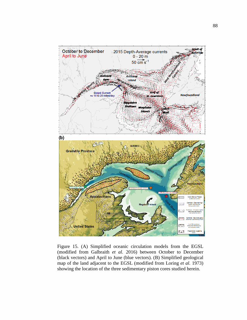
88
Figure 15. (A) Simplified oceanic circulation models from the EGSL (modified from Galbraith et al. 2016) between October to December (black vectors) and April to June (blue vectors). (B) Simplified geological map of the land adjacent to the EGSL (modified from Loring et al. 1973) showing the location of the three sedimentary piston cores studied herein.

89
1.4. MATERIAL AND METHODS
1.4.1. SAMPLES
Three sediment cores from the lower St. Lawrence Estuary (COR0602-36PC) and Gulf
of St. Lawrence (COR0503-CL04-36 and COR0503-CL05-37) were collected on board the
research vessel (R/V) Coriolis II during two different cruises in June 2005 (COR0503) and
2006 (COR0602) (Table 1). These sediment cores were recovered along the axis of the
Laurentian Channel, from its head to its mouth (Figure 15B) using a piston corer, allowing the
sampling of cores up to 7.90 m. All coring sites were targeted using high-resolution seismic
profiles that indicated high sediment accumulation not influenced by mass wasting events
(Barletta et al. 2010).
Table 1. Coordinates and lengths of the three sedimentary piston cores studied herein.
Samples for bulk mineralogical analysis were evenly sampled at 5-cm intervals (total of
456 samples). Complementarily, major and minor element concentrations were determined at
15-cm intervals, whereas sediment grain-size analyses were performed at 10-cm intervals.
Before the bulk mineralogical and geochemical analysis and in order to isolate the detrital
fraction from these sediment samples, organic matter and biogenic carbonate were removed
with 10 mL of peroxide (30%) and 10 mL of hydrochloric acid (0.5 N), respectively. Biogenic
silica was not removed as it appeared to be negligible (likely less than 1%, as suggested by
the fact it was not detected in the bulk sediment XRD diffractograms). Next, sediment
90
samples were rinsed five times with distilled water and ground with a McCrone micronizing
mill with agate grinding elements to obtain a consistent grain size of <10 μm using 5 mL of
ethanol and grinding times of 5–10 min to obtain a homogenous powder. The slurry was oven
dried overnight at about 60 °C and then slightly homogenized with an agate mortar to prevent
the possible agglomeration of finer particles during drying. Aliquots of these homogenized
sediment samples were used for bulk mineralogical and geochemical analysis.
1.4.2. CHRONOSTRATIGRAPHIC FRAMEWORK
The chronostratigraphic framework of all sediment cores used in this study was
published previously and derived from 17 AMS-14C ages obtained on marine mollusc shell
fragments (Barletta et al. 2010). Further support of the age model of core COR0602-36PC
comes from comparison of magnetic susceptibility profiles of the lower part (562 cm) of the
core with nearby core MD99-2221 (St-Onge et al. 2003) (Annexe 1). Characteristic peaks in
both magnetic susceptibility curves have been identified in order to transfer the age model of
core MD99-2221 to core COR0602-36PC below 562 cm where no radiocarbon ages are
available. The R software package BACON (Blaauw & Christen 2011) was used to produce
the “best fit” linearly interpolated age models. BACON uses a Bayesian approach to estimate
the best fit or weighted mean age for each depth with a 95% confidence interval. Overall, the
chronostratigraphic framework of all these sediment cores suggests high sedimentation rates
in the last 10 cal. ka BP (300 to 40 cm ka-1; Figure 16).

91
Figure 16. Age models for cores COR0602-36PC, COR0503-CL05-37PC and COR0503-CL04-36PC. Modified from Barletta et al. (2010).
1.4.3. ANALYTICAL PROCEDURE
1.4.3.1. PHYSICAL PROPERTIES: MULTISENSOR CORE LOGGER ANALYSES.
The physical properties were measured using a GEOTEK Multi Sensor Core Logger
(MSCL) at the Institut des sciences de la mer de Rimouski (ISMER). Diffuse spectral
reflectance data were acquired at 5-cm resolution immediately after splitting the core, using
an X-Rite DTP22 hand-held spectrophotometer and are reported in the L*, a*, b* colour

92
space of the International Commission on Illumination (CIE). L* is a black to white scale, a*
is a green to red scale, and b* is a blue to yellow scale (e.g. St-Onge et al. 2007; Debret et al.
2011). Note that a* was only used in this study because this can be a useful parameter to
detect changes in the concentration of high-coercivity red minerals such as hematite (St-Onge
& Lajeunesse 2007).
1.4.3.2. GRAIN SIZE DISTRIBUTION AND END-MEMBER MODELLING ANALYSIS.
Sediment grain-size analyses were performed on bulk sediment samples using a
Beckman Coulter LS13320 laser diffraction grain-size analyzer. Defloculation of the samples
was done by mixing about 0.5 g of wet sediment with Calgon electrolytic solution (sodium
hexametaphosphate, 20 g L-1) and subsequently shaking for at least 3 h using an in-house
rotator. Grain-size distribution and statistical parameters (e.g., mean, sorting) were calculated
using the moment methods from the GRADISTAT software (Blott & Pye 2001). Also, the
end-member modelling algorithm (EMMA) developed by Weltje (1997) and adapted by
Dietze et al. (2012) was applied to the grain-size data in order to extract meaningful end-
member (EMs) grain-size distributions and estimate their proportional contribution to the
sediments. The cumulative explained variance (r2) was calculated in order to assess the
minimum number of EMs needed for a good estimate of our grain-size data (e.g. Weltje 1997;
Prins & Weltje 1999; Dietze et al. 2012). A more detailed description of the EMMA method
that we applied can be found in Dietze et al. (2012). Overall, grain-size distribution and end-
member modelling analysis were used to investigate the sedimentary transfer regime because
sediment grain-size distribution (primarily driven by sedimentary processes) reflects transport
conditions (e.g. Montero-Serrano et al. 2009, 2010a; Dietze et al. 2012; Simon et al. 2012;
Stuut et al. 2014).

93
1.4.3.3. BULK SEDIMENT MINERALOGY.
The random powder samples were side-loaded into the holders and analysed by X-ray
diffraction (XRD) using a PANalytical X’Pert Powder diffractometer. This instrument is
fitted with a copper tube (Cu K-alpha = 1.54178Å) operating at 45 kV and 40 mA and a post-
diffraction graphite monochromator. Samples were scanned from 5° to 65° two-theta in steps
of 0.02° two-theta and a counting time of 2 seconds per step. For the semi-quantification of
the major mineralogical components, the bulk sediment XRD scans obtained were processed
in the software package X’Pert High-Score Plus (PANalytical) using the Rietveld full-pattern
fitting method (e.g. Young 1993; Grunsky et al. 2013). This method permits the semi-
quantification of whole-sediment mineralogy with a precision of 5–10% for phyllosilicates
and 5% for non-phyllosilicates minerals. The quality of the Rietveld fitting procedure was
evaluated for two statistical agreement indices: R-profile and goodness-of-fit (GOF). R-
profile quantifies the difference between the observed and calculated patterns, whereas the
GOF is the ratio between the R-weighted profile (RWP; best fit of least squares between
observed and calculated patterns) and R-expected theoretical (Rexp; best possible value for
the residual). R-values profile between 20–30% and GOF of less than 3 are typically adequate
in the Rietveld refinement of geological samples (e.g. Young 1993). The major mineralogical
components quantified by this technique are: quartz, potassium (K) feldspar (microcline +
orthoclase), plagioclase feldspar (albite + anorthite), amphibole (hornblende), pyroxene
(augite), magnetite, hematite, goethite, calcite, dolomite, and phyllosilicates (biotite,
muscovite, illite, chlorite, and kaolinite).

94
1.4.3.4. ELEMENTAL GEOCHEMISTRY.
A total of 14 elements (Al, Si, K, Mg, Ca, Ti, Mn, Fe, P, Sr, V, Cr, Zn, and Zr) were
analysed by energy dispersive X-ray fluorescence (EDXRF) spectrometry using a
PANalytical Epsilon 3-XL. Before EDXRF analysis, loss on ignition (LOI) was determined
gravimetrically by heating the dried samples up to 950 °C for two hours. Subsequently,
samples were treated by borate fusion in an automated fusion furnace (CLAISSE® M4
Fluxer). Samples weighing ~0.6 g were mixed with ~6 g of lithium borate flux (CLAISSE,
pure, 49.75% Li2B4O7, 49.75% LiBO2, 0.5% LiBr). The mixtures were melted in Pt-Au
crucibles (95% Pt, 5% Au), and after fusion the melts were cast to flat disks (diameter: 32
mm; height: 3 mm) in Pt–Au moulds. Acquired XRF spectra were processed with the
standardless Omnian software package (PANalytical). The resulting data are expressed as
weight percent (wt.% ; Al, Si, K, Mg, Ca, Ti, Mn, Fe, P) and micrograms per gram (μg g-1; V,
Cr, Zn, Sr, Zr). Procedural blanks always accounted for less than 1% of the lowest
concentration measured in the sediment samples. Analytical accuracy and precision were
found to be better than 1–5% for major elements and 5–10% for the other elements, as
checked by an international standard (USGS SDC‐1) and analysis of replicate samples.
1.4.3.5. MAGNETIC REMANENCE ANALYSES.
The isothermal remanence magnetization (IRM), and saturated isothermal remanent
magnetization (SIRM) measurements of all the sediment cores used in this study were
published previously by Barletta et al. (2010). These measurements were acquired on u-
channel samples at 1-cm intervals using a 2G Enterprises SRM-755 cryogenic magnetometer
in order to identify and characterize the magnetic concentration, mineralogy and grain size.
The IRM was imparted using a 2G Enterprises pulse magnetizer with a direct current field of

95
0.3 T, whereas the SIRM was imparted using a field of 0.95 T. We use the IRM/SIRM ratio
measured at 0 mT (referred to as the pseudo S-ratio, St-Onge et al. 2003) to estimate the
magnetic mineralogy, with values close to 1 indicating lower coercivity minerals such as
magnetite, whereas lower values indicate a contribution from higher coercivity minerals such
as hematite (Stoner & St-Onge 2007).
1.4.3.6. STATISTICAL APPROACH
The mineralogical and geochemical data are of a compositional nature, that is, they are
vectors of non-negative values subjected to a constant-sum constraint (100%). This implies
that relevant information is contained in the relative magnitudes, so statistical analysis must
focus on the ratios between components (Aitchison 1986). In this context, principal
component analysis (PCA) was performed on the mineralogical and elemental geochemical
datasets with the goal of finding associations with similar relative variation patterns that may
be interpreted from a paleoenvironmental standpoint (e.g. von Eynatten et al. 2003; Montero-
Serrano et al. 2010b, 2015; von Eynatten et al. 2016). For the PCA with mineralogical data,
we selected four key minerals (quartz, K-feldspar, plagioclase, and phyllosilicates) that
represented more than 97% of the overall mineral concentration in the sediment sample. For
the PCA with elemental data, we used all major and minor elements analysed as well as LOI.
Prior to PCA, a log-centred (clr) transform was applied to the data set (Aitchison 1990). The
clr transform is derived by dividing each variable (e.g., mineral percentage, element
concentration) by the geometric mean of the composition of the individual observations and
then taking the logarithm. This operation removes statistical constraints on compositional
variables, such as the constant-unit sum, and allows the valid application of classical
(Euclidean) statistical methods to compositional data (Aitchison 1986, 1990). PCA was

96
conducted with “R” software using the package “compositions” (van den Boogaart &
Tolosana-Delgado 2008) (Figure 17).
All analytical data presented are available electronically in the PANGAEA database
(https://doi.pangaea.de/10.1594/PANGAEA.868771).

97
Figure 17. Biplots of the PC-1 versus PC-2 obtained from the log-centred transformation of the bulk mineralogical and geochemical data for cores COR0602-36PC (A) (B), COR0503-CL05-37PC (C) (D) and COR0503-CL04-36PC (E) (F).

98
1.5. RESULTS
1.5.1. SEDIMENT CHARACTERISTICS AND CHRONOSTRATIGRAPHIC FRAMEWORK
In this study, all the sediment cores present two distinct sedimentary units. According to
Barletta et al. (2010), the upper unit is composed of dark grey, bioturbated silty clays to sandy
mud, whereas the lower unit is composed of lighter grey and relatively homogeneous, slightly
bioturbated clayey silts to silty clays (Figure 18). The mean sedimentation rates of the cores
COR0602-36PC and COR0503-CL05-37PC revealed an abrupt change around 8.5 cal. ka,
with variations from ~300 to ~40 cm ka-1 (Figure 16). Conversely, the core located at the most
seaward location (COR0503-CL04-36PC) do not show any significant change in the mean
sedimentation rates (~75 cm ka-1) throughout the Holocene.
Figure 18. Mean grain size versus depth for cores COR0602-36PC, COR0503-CL05-37PC and COR0503-CL04-36PC. The grey and orange areas represent glaciomarine and postglacial sediments, respectively. The sediment texture is indicated to the right of each diagram. St-c = silty clays; C-st = clayey silts; St = silts; S-md = sandy muds. Modified from Barletta et al. (2010).

99
1.5.2. GRAIN-SIZE END-MEMBER
The algorithm of end-member modelling analysis EMMA revealed a four-EM model to
explain more than 95% of the total variance for each core (Figure 19). Every core is
characterized by four grain classes: end-member EM4 is associated to the very coarse silts to
fine sands (30 to 234 µm), end-members EM2 and EM3 correspond to the fine to medium (6
to 18 µm) and medium to coarse (9 to 63 µm) silts, and end-member EM1 is associated to the
clays (<2 µm). The relative contributions of the four end-members are plotted against age in
Fig. 5. All samples from the three sediment cores are mainly composed of fine-grained
detrital sediments (<20 µm). Indeed, the end-members EM1+EM2 represented 67, 74 and
78% of the overall grain-size variance for the cores COR0503-CL04-36PC, COR0503-CL05-
37PC and COR0602-36PC, respectively. Based on these results, the Log(EM2/EM1) ratio is
used here to elucidate down-core grain-size variations (silts vs. clay) within the Laurentian
Channel detrital sediments, and to investigate sediment transfer and transport conditions
during the glaciomarine and postglacial sedimentation.

100
Figure 19. End-member modelling analyses (EMMA) performed on the grain-size distribution of the detrital fraction of cores COR0602-36PC (A), COR0503-CL05-37PC (B) and COR0503-CL04-36PC (C). The grain-size distribution of the four first end-members accounts for more than 95% of the total variance. Four representative unmixed grain-size distributions as well as end-member scores (%) derived from EMMA are shown.

101
1.5.3. MINERALOGICAL AND GEOCHEMICAL ASSOCIATIONS
Stratigraphic distributions of the bulk mineralogical and geochemical data from the
three sedimentary cores studied here are available in Annexe 2. To gain a better understanding
of the mineral and elemental associations and their relationship with sediment samples, PCA
was conducted on all sediment cores (Figure 17). We illustrate the scores from the first two
principal components of the log-centered data as these accounts for more than 90% of the
total variance. According to PCA results, glaciomarine sediments in the lower St. Lawrence
Estuary (COR0602-36PC) are associated mainly with phyllosilicates, K-feldspar, and Mg-Cr-
Fe-Zn-Al-K-V-LOI, whereas postglacial sediments are characterized by the association of
plagioclase-quartz and Si-Zr-Ti-Ca-Sr. In contrast, glaciomarine sediments in the Gulf of St.
Lawrence (COR0503-CL04-36PC and COR0503-CL05-37PC) are typified mainly by the
association of K-feldspar and plagioclase with Mg-Sr-Cr-K-Al-Fe and to a lesser extent with
Si-Ti and Mn, whereas postglacial sediments are associated with phyllosilicates-quartz and
Ca-LOI-V-Zn-Mn-Si-Ti-Zr. Similarly, we note that the fine-grained glaciomarine sediments
in the estuary are characterized by abundant phyllosilicates, while sediments in the gulf are
dominated by K-feldspar and plagioclase (Figure 17). This most likely suggests that the fine-
grained glaciomarine sediments in the gulf contain higher proportions of rock flour derived
from glacial erosion of the crystalline rocks on the Canadian Shield (Loring & Nota 1973).
These mineralogical and geochemical differences between the Estuary and Gulf of St.
Lawrence may be related to different sediment sources and hydrodynamic sorting. Therefore,
based on PCA results, we selected the phyllosilicates/(plagioclase+K-feldspar), Log(Zn/Sr),
Log(Si/K), and Log(Zr/Al) ratios to reconstruct down-core changes in sediment provenance
and transport in the EGSL over the last 10 cal. ka BP (Figure 20, Figure 21, Figure 22). The
phyllosilicates/(plagioclase+K-feldspar) ratio provides a straightforward proxy to discriminate

102
the sediments from the South Shore (Paleozoic sedimentary rocks) from those from the North
Shore (Grenvillian metamorphic rocks). In fact, as suggested in Loring & Nota (1973) and
Jaegle (2015), plagioclases and K-feldspars as well as amphibole, pyroxene, and magnetite
are more abundant along the North Shore, whereas phyllosilicates, quartz, and Fe-oxides
(notably, hematite and goethite) are more common along the South Shore and the Canadian
Maritime Provinces (on the southwest gulf). Likewise, the fact that Log(Zn/Sr) ratios reflect
sediment source is based on preferential Zn concentration in phyllosilicate minerals, whereas
Sr is associated with plagioclase−K-feldspar minerals (Figure 17). However, because Sr may
also be associated with Ca in the biogenic and detrital carbonate fraction (notably, dolomite),
the presence of high concentrations of carbonates can influence this ratio. In this study, the
biogenic carbonates were generally removed from all cores by weak acid treatment; however,
dolomite is not always removed following this attack (Figure 20i, Figure 21i, Figure 22i).
Such is the case for core COR0503-CL05-37PC, collected close to Anticosti Island, where
dolomite contents (Figure 21i) are particularly high in some intervals (up to 12%) compared
to cores COR0602-36PC and COR0503-CL04-36PC (<3%; Figure 20I and Figure 22i). In
these circumstances and based on the PCA results, we prefer to use the Log(Si/K) ratio rather
than Log(Zn/Sr) to track changes in sediment provenance south of Anticosti Island
(COR0503-CL05-37P). A high Log(Si/K) ratio reflects a greater contribution from Si-rich
minerals (notably, quartz), whereas low ratios suggest the input of feldspar-rich minerals,
notably K-feldspar (Figure 17). At the same time, changes in sediment grain size are also
investigated by comparing the Log(Zr/Al) ratios. Zr is concentrated in zircon grains in the
coarser fractions, whereas Al is preferentially associated to clay minerals and aluminosilicates
in the fine-grained fractions (e.g. von Eynatten et al. 2012).

103
Figure 20. Multiproxy analysis for core COR0602-36PC. A. Relative sea level variations at Sept-Iles (Shaw et al. 2002). B. Geochemical log-ratio Zn/Sr. C. Mineralogical ratio phyllosilicates/(plagioclase+K-feldspar). D. Grain-size end-members Log(EM2/EM1). E. Geochemical log-ratio Zr/Al. F. Pseudo S-ratio magnetic parameter. G. Magnetic susceptibility (klf). H. a* indicates sediment colour variations from green to red. I. Dolomite content variations. Note that, organic matter and biogenic carbonate were removed with peroxide (30%) and hydrochloric acid (0.5 N), respectively, before bulk mineralogical analysis.

104
Figure 21. Multiproxy analysis for core COR0503-CL05-37PC. A. Relative sea level at the eastern New Brunswick (Shaw et al. 2002). B. Geochemical log-ratio Si/K. C. Mineralogical ratio phyllosilicates/(plagioclase+K-feldspar). D. Grain-size end-members Log(EM2/EM1). E. Geochemical ratio Zr/Al. F. Pseudo S-ratio magnetic parameter. G. Magnetic susceptibility (klf). H. a* indicates sediment colour variations from green to red. I. Dolomite content variations. Note that, organic matter and biogenic carbonate were removed with peroxide (30%) and hydrochloric acid (0.5 N), respectively, before bulk mineralogical analysis.

105
Figure 22. Multiproxy analysis for sedimentary core COR0503-CL04-36PC. A. Relative sea level at Port au Port (Shaw et al. 2002). B. Geochemical log-ratio Zn/Sr. C. Mineralogical ratio phyllosilicates/(plagioclase+K-feldspar). D. Grain-size end-members Log(EM2/EM1). E. Geochemical log-ratio Zr/Al. F. Pseudo S-ratio magnetic parameter. G. Magnetic susceptibility (klf). H. a* indicates sediment colour variations from green to red. I. Dolomite content variations. Note that, organic matter and biogenic carbonate were removed with peroxide (30%) and hydrochloric acid (0.5 N), respectively, before bulk mineralogical analysis.

106
1.5.4. LAURENTIAN CHANNEL SEDIMENT CORES
Because the last deglaciation and Holocene sediment dynamics did not evolve
synchronously throughout the EGSL (e.g. Dionne et al. 1977; Barletta et al. 2010; Levac et
al. 2015; Rémillard et al. 2016), the mineralogical, geochemical, grain size, magnetic, and
spectral reflectance results obtained for each sediment core are presented by geographic
location as follows:
1.5.4.1. LOWER ST. LAWRENCE ESTUARY: CORE COR0602-36PC.
Sediments between 9 and 8 cal. ka BP in core COR0602-36PC are mainly composed of
clay (up to 80% EM1) and minor amounts of fine to medium silts (~20% EM2). This grain-
size trend is reversed after 8 cal. ka BP with the occurrence of several thin coarser layers
(EM3 and EM4; Figure 19A). The vertical distribution of physical, magnetic, mineralogical,
and geochemical proxies reveals significant downcore variations (Figure 20). Indeed, the a*
(0.33 to -1.14), Log(Zn/Sr) (-0.71 to -0.29), and phyllosilicate/(plagioclase+K-feldspar) (0.95
to 0.22) records show similar patterns, with maximum values in the lowermost part of the core
(~9 cal. ka BP), which sharply decrease between 9 and 8 cal. ka BP, and minimum values
with few variations upwards from 8 cal. ka BP to the present. Conversely, the pseudo S-ratio
(0.95 to 1.04), magnetic susceptibility (klf; 67 to 680 x10-5 SI), Log(Zr/Al) ratio (-2.92 to -
2.42), and Log(EM2/EM1) (-0.95 to 1.51) records show minimum values in the lowermost
part of the core, which slowly increase between 9 to 8 cal. ka BP, and maximum values with
few variations in the uppermost part of the core (8 cal. ka BP to present). Variations in the
Log(Zr/Al) ratio are well correlated with changes in the proportion of the Log(EM2/EM1)
ratio (Figure 20D, E). Detrital carbonate concentrations in this sediment core are negligible
(<0.5%) and no major changes are recorded over time.
107
1.5.4.2. SOUTH OF ANTICOSTI ISLAND: CORE COR0503-CL05-37PC.
In core COR0503-CL05-37PC, the clay (EM1) content increases from 10 to 9 cal. ka
BP (up to 96% EM1), remains high but fluctuates between 20-60% until 5 cal. ka BP, and
then gradually decreases to become almost non-existent from 5 cal. ka BP to the present. The
sum of all the coarse fractions (EM2 + EM3 + EM4) represents more than 80% of the particle
size before 9 cal. ka BP, and both the fine to medium silts (EM2) and very coarse silt to fine
sand (EM4) particles have dominated over the last 6 cal. ka BP (Figure 19B). Downcore
profiles of pseudo S-ratio, Log(EM2/EM1), and Log(Zr/Al) ratios show a similar stratigraphic
trend, with higher values in the lowermost and uppermost parts of the core (Figure 21). The
magnetic parameter pseudo S-ratio decreases slightly from 0.98 to 0.93 between 10.5-6 cal. ka
BP, and then slowly increase up-core (Figure 21F). The Log(EM2/EM1) ratio decrease from 1
to -1 between 10.5-8.5 cal. ka BP, and then slowly increase during the last 8.5 cal. ka BP
(Figure 21D). The Log(Zr/Al) ratio show maxima at the base of the core (up to -2.70) and
decrease to reach its minima at 8.5 cal. ka BP (down to -2.96) and then increases (up to -2.77)
up-core (Figure 21E). Similarly, a* and magnetic susceptibility (klf) records show maximum
values (a* = 3.5; klf = 50 x10-5 SI) in the lowermost parts of the core (10.5–9.5 cal. ka BP),
whereas the lowest values (a* = -1.7; klf = 14 x10-5 SI) are characteristically in the uppermost
part (Figure 21G, H). The vertical distribution of phyllosilicates/(plagioclase+K-feldspar)
show maxima at the base of the core (up to 1.27) and decrease to reach its minima at 9.5 cal.
ka BP (down to 0.65) and then increases upwards (up to 1.04) (Figure 21C). Similar to the
mineralogical ratio, the Log(Si/K) ratio also reveals higher values (up to 0.97) between 10.5
and 9.5 cal. ka BP, which gradually decreases until 9 cal. ka BP (down to 0.91), and then
increases (up to 1.03) during the mid to late Holocene (Figure 21B). Both
phyllosilicates/(plagioclase+K-feldspar) and Log(Si/K) depict a sharp upswing centered at
108
about 5 cal. ka BP. High detrital carbonate concentrations (10–12 %) are recorded between
10.5–9.5 and 6.5–4 cal. ka BP (Figure 21I).
1.5.4.3. CABOT STRAIT: CORE COR0503-CL04-36PC.
In core COR0503-CL04-36PC, sediments between 10.5 and 8.5 cal. ka BP are mainly
composed of clay (up to 80% EM1), whereas fine to medium silts (EM2) and very coarse silts
(EM4) dominate during the last 8.5 cal. ka BP (Figure 19C). Down core profiles of
phyllosilicates/(plagioclase+K-feldspar) (0.9 to 1.8), Log(Zn/Sr) (-0.39 to -0.07), and
Log(Zr/Al) (-2.95 to -2.75) ratios mimic the stratigraphic trend of the Log(EM2/EM1) ratio (-
2.12 to 2.40), with the lowest values between 10.5 and 8.5 cal. ka BP, which gradually
increase between 8.5 to 6 cal. ka BP, and higher values during the last 6 cal. ka BP (Figure
22). These detrital proxies show few variations during the last 6 cal. ka BP. The a* records
reveals minima in the lowermost (10.5–8.5 cal. ka BP; down to -2.26) and uppermost (2.5–1
cal. ka BP; down to -1.00) parts of the core, and maxima between 8.5–2.5 cal. ka BP (up to
1.52) and during the last 1 cal. ka BP (up to 1.64) (Figure 22H). The magnetic susceptibility
(klf) record presents maxima (up to 20 x10-5 SI) in the lowermost parts of the core (10.5–9 cal.
ka BP), which decreases abruptly at about 9 cal. ka BP (down to 8.4 x10⁻⁵ SI) and peaks again
until ~8 cal. ka BP (up to 16 x10-5 SI), then slowly decreases (Figure 22G). The pseudo S-
ratio decreases from 0.97 to 0.83 between 10-6 cal. ka BP, and then slowly increase up-core
(Figure 22F). The pseudo S-ratio inversely mimic the stratigraphic trend of the
Log(EM2/EM1) ratio. Relatively higher detrital carbonate concentrations (up to 3%) are
observed between 7–5, 3.5–2.5, and the last 1 cal. ka BP (Figure 22I).

109
1.5.5. INTERPRETATION AND DISCUSSION
During the last deglaciation, the earth’s orbital configuration induced a strong summer
insolation maximum and winter insolation minimum in the Northern Hemisphere (Berger &
Loutre 1991). This strong boreal summer insolation induced a rapid retreat of the LIS (e.g.
Carlson et al. 2008, 2009; Montero-Serrano et al. 2009, 2011). During this early stage, the
rapid hinterland retreat of the LIS triggered major changes in the EGSL system, engendering
alterations in proglacial drainage and relative sea-level (Figure 23; Dyke et al. 1987, Shaw
2006).
Under this context, the lowermost and the uppermost sedimentary units observed in our
three sedimentary cores (Figure 18) have been interpreted as glaciomarine and postglacial
sediments, respectively (Josenhans & Lehman 1999; St-Onge et al. 2003). The abrupt change
of the mean sedimentation rates from ~300 to ~40 cm ka-1 observed on the core COR0602-
36PC and COR0503-CL05-37PC around 8.5 cal. ka BP (Figure 16) has already been
observed by St-Onge et al. (2003, 2009) in cores MD99-2220 and MD99-2221 collected in
the lower St. Lawrence Estuary. They associated this observation with a significant reduction
in sediment inputs following the re-routing of the LIS meltwaters from the St. Lawrence
Estuary to the Hudson Bay and Strait following the catastrophic drainage of the glacial Lake
Agassiz-Ojibway at ~8.47 cal. ka BP (Lajeunesse & St-Onge 2008). However, as previously
pointed out by Barletta et al. (2010), a drastic changes in sedimentation rates throughout the
Holocene is not observed in the core located at the most seaward location (COR0503-CL04-
36PC), possibly resulting from the scarcity of dated material prior to 8.5 cal. ka BP.
The long-term variations observed in our physical, grain-size, mineralogical,
geochemical, and magnetic records are discussed below in this context in terms of changes in
detrital sediment supply, provenance, and transport, and their possible relations with both the
deglacial/Holocene climate variability and glacio-isostatic relative sea-level variations.

110
Figure 23. Evolution of the relative sea level over the last 10 000 years (Shaw et al. 2002) represented on three different places from the Estuary and Gulf of St. Lawrence: Sept-Isles (A), New-Brunswick border (B) and Port au Port (C). Two zones described by Clark et al. (1978) have also been represented (the inset at the top left): Zone 1 had a relative sea level around 80 m higher at 10 cal. ka BP and progressively decreases until today; and Zones 1–2 (a transition zone) had a higher sea level followed by a lower relative sea level around 8 cal. ka BP, and a gradual re-increase in sea level after that. The positions of the three sedimentary cores studied here are also shown.

111
1.5.5.1. SEDIMENTARY REGIME DURING DEGLACIATION (10–8.5 KA) — MELTWATER DISCHARGES
The high sedimentation rates (~300 cm ka-1) in the thick fine-grained sedimentary
successions during deglaciation (10–8.5 cal. ka BP) suggest sedimentary dynamics mainly
controlled by the meltwater discharge from the local retreat of the southeastern margin of the
LIS on the Canadian Shield (e.g. Syvitski & Praeg 1989; St-Onge et al. 2003, 2008). This
observation is in agreement with the regional deglaciation pattern of the LIS on the Canadian
Shield summarized by Shaw (2006). Indeed, around 13 cal. ka BP, large marine areas of
Atlantic Canada were ice free (e.g. Rémillard et al. 2016), but glaciers remained on most land
areas. At 9 cal. ka BP, glacier ice remained only in the Quebec and Labrador regions (Figure
24). Extensive emerged areas could be found on the Grand Banks and on the Scotian Shelf,
and large parts of the southern Gulf of St. Lawrence (Shaw 2006). All these observations
concurred to highlight the presence of the LIS on the North Shore in the early Holocene
(Dyke & Prest 1987; Syvitski & Praeg 1989; Shaw et al. 2006), which may explain the large
amount of meltwater discharges into the EGSL.
In the lower estuary, the phyllosilicates/(plagioclase+K-feldspar) and Zn/Sr ratios as
well as the a* and pseudo S-ratio indicate a mixed provenance of detrital particles between 9
and 8.5 cal. ka BP, that is, mainly from the North Shore, but with a noticeable contribution
from the South Shore (Figure 24). We hypothesize that this sediment mixture is likely due to
the close proximity of the LIS margin to the North Shore (e.g. Clark et al. 1978; Dyke &
Peltier 2000; Shaw et al. 2002). The glacio-isostatic loading by the LIS over the lower estuary
was greater compared to the Gulf, and induced a higher relative sea level (>100 m) during the
early Holocene than at present (Figure 23A; Clark et al. 1978, Shaw 2006). Such conditions
likely promoted an increase in coastal erosion on the South Shore and, therefore, a larger
sediment supply from this area.
112
In the area south of Anticosti Island (COR0503-CL05-37PC), mineralogical,
geochemical, and magnetic variations observed between 10.5 and 9.5 cal. ka BP also suggest
a mixture of sediment provenances. However, the relative sea level was lower in the Gulf
(about -20 to -30 m below present sea level; Shaw et al. 2002; Rémillard et al. 2016) than in
the lower part of the estuary as the LIS margin was more distant (~400 km NW; Shaw 2006;
Figure 23). In agreement with Loring & Nota (1973), we hypothesize that these lowstand
conditions promoted the remobilization of reddish-brown glacigenic sediments stored on the
Magdalen Shelf as well as subsequent transport towards the Laurentian Channel. Surface
sediments in the Magdalen Shelf are mainly composed of erosional products derived from
Palaeozoic sedimentary rocks of the Appalachian province, which are rich in quartz,
phyllosilicates, and hematite (which imparts a reddish hue to sediments) and minor amounts
of glacigenic sediments derived from crystalline rocks of the Canadian Shield characterized
by an abundance of feldspars, amphibole, and magnetite (Loring & Nota 1973). The
glacigenic materials from the Canadian Shield were transported to the Magdalen Shelf by
southward advances of the LIS during the late Wisconsin glaciation (Loring & Nota 1973).
Very large increases in a* values (red), the Zr/Al ratio, and magnetic susceptibility (klf)
observed at the base of core COR0503-CL05-37PC support the interpretation of the South
Shore sedimentary origin (Figure 21).
Concurrently, in Cabot Strait (COR0503-CL04-36PC), the low
phyllosilicates/(plagioclase+K-feldspar) and Zn/Sr ratios as well as higher Pseudo S-ratio
(magnetite) and magnetic susceptibility (klf) values observed during the early Holocene
suggest that the detrital sediments mainly originated from the North Shore with a minor
influence from the Canadian Maritime Provinces. These results are coherent with those
obtained by Stevenson et al. (2008), whose less-radiogenic ɛNd signatures obtained on a core
taken from the upper slope of the western Grand Banks reveal an increase in the relative
contribution of the North American Shield since 13 ka.
113
Furthermore, results obtained from the end-member modelling analysis EMMA reveal
the dominance of clay and very fine detrital silt particles in the early Holocene in all sediment
cores (Figure 19). This observation is also confirmed by the low Zr/Al ratio values, indicating
high amounts of fine-grained Al-rich mineral at the base of all cores. In agreement with
several sedimentological studies (e.g. Loring & Nota 1964; Josenhans & Lehman 1999; St-
Onge et al. 2008, 2011), we hypothesize that sediment-laden meltwater plumes derived from
the North Shore, together with a relatively higher sea level than today (Clark et al. 1978),
induced the accumulation of fine-grained sediments in the ice-distal zones of the EGSL
during deglaciation. Indeed, the weak hydrodynamic conditions prevailing in these ice-distal
glaciomarine environments caused a less turbulent depositional setting and, therefore, the
preferential accumulation of fine-grained sediments.
To summarize, our results suggest that, between 10 to 8.5 cal. ka BP, sediment supply
in the EGSL became primarily controlled by the LIS meltwaters from the North Shore and
secondarily by glacio-isostatic relative sea-level variations.
1.5.5.2. SEDIMENTARY REGIME DURING THE HOLOCENE (8.5 CAL. KA BP TO PRESENT) — POSTGLACIAL RELATIVE SEA-LEVEL VARIATIONS
The decrease in the sedimentation rate from about 300 to 40 cm ka-1 observed at ~8.5
cal. ka BP (Figure 16) provides evidence for a drastic decrease in erosional processes in the
EGSL as the LIS margin withdrew from its southeasternmost extent and the meltwater
discharges re-routed towards Hudson Bay and Strait (St-Onge et al. 2003, 2011).
Consequently, the variations in grain size, mineralogical, geochemical, and magnetic
susceptibility observed after 8.5 cal. ka BP cannot be related to changes in the extent of the
LIS. Instead, variations in our detrital proxies are most likely related to relative changes in sea
level in response to glacio-isostatic rebound (Dionne 1977; Clark et al. 1978; Shaw et al.

114
2002, 2006). According to Clark et al. (1978), the timing and magnitude of this postglacial
isostatic rebound, and therefore changes in relative sea level, were not uniform in eastern
Canada. The glacio-isostatic rebound varies spatially depending on both ice thickness and the
location of a particular area relative to the ice margin (Licciardi et al. 1999; Dyke & Peltier
2000; Dionne 2001; Shaw et al. 2002; Rémillard et al. 2016). Accordingly, relative sea-level
variations were not similar along the east–west coring transect during the last 10 cal. ka BP
(Figure 23). Indeed, one of the cores (COR0602-CL04) was sampled in Zone 1 of Clark et al.
(1978), which experienced a sea level about 120 m higher at 10 cal. ka BP than the current
level, and which has been progressively decreasing to the present. The two other cores
(COR0503-CL05-37PC and COR0503-CL04-36PC) were collected in the transition zone
(between zones 1 and 2), which experienced higher sea level than the present between 10–8
cal. ka BP, then a lower relative sea level around 8 cal. ka BP (around -20 m), and finally, a
progressive sea level rise to the present (Figure 23).
In this context, we compare our detrital proxy data with the relative sea level curve that
is closest geographically (Figure 23) in order to deduce potential relations between relative
sea-level variations and sediment dynamics in the EGSL over the last 8.5 cal. ka BP (Figure
20, Figure 21, Figure 22). Based on the regional studies of Clark et al. (1978) and Shaw et al.
(2002), we selected three relative sea-level curves along the east–west coring transect: (i) the
Sept-Îles curve on the North Shore was compared with core COR0602-36PC from the estuary
(Figure 20A), (ii) the eastern New Brunswick curve was compared with core COR0503-
CL05-37PC (Figure 21A), and (iii) the Port au Port curve on Newfoundland’s west coast was
compared to core COR0503-CL04-36PC (Figure 22A). All relative sea-level curves reveal a
parallel temporal evolution with grain-size, magnetic, mineralogical, and geochemical proxies
(Figure 20, Figure 21, Figure 22). These observations suggest that glacio-isostatic relative
sea-level variations have exerted a significant control on sedimentation in the EGSL over the
last 8.5 cal. ka BP.
115
In the gulf, the mineralogical and geochemical signatures of cores COR0503-CL05-
37PC and COR0503-CL04-36PC indicate that detrital sediments derived primarily from the
Canadian Maritime Provinces and the South Shore, as evidenced by an increase in
phyllosilicates (up to 46%) and quartz (up to 28%) relative to feldspars. Based on coastal
currents patterns in the EGSL (Figure 15A), we suggest that the Appalachian sediments
observed in these cores are mainly transported via the Gaspé Current. This current has
sufficient energy (21 to 42 cm sec-1; Trites 1972; Couillard 1980) to transport Appalachian
sediments from the South Shore and Canadian Maritime Provinces to the Gulf (Loring &
Nota 1973; Dufour & Ouellet 2007). Indeed, the outward transport that integrates all currents
heading toward the ocean near Honguedo Strait ranges between 0.937 Sv ±0.233 in December
and 0.460 Sv ±0.086 in June (Galbraith et al. 2016). According to Sheng (2001), this coastal
current is separated in two branches past the tip of the Gaspé Peninsula: the south branch
flows over the Magdalen Shelf and along the Canadian Maritime Provinces coast, whereas the
north branch flows along the western edge of the Laurentian Channel. In this context, the
south branch forms the main outflow of the Gulf on the western side of Cabot Strait and may
therefore supply sediments from the Canadian Maritime Provinces to the core COR0503-
CL04-36PC. Conversely, the north branch may supply to the core COR0503-CL05-37PC
sediments derived mainly from the South Shore and in minor proportion from the North
Shore.
However, we do not rule out that erosion of the Palaeozoic sedimentary rocks cropping
out along the west coast of Newfoundland might also act as a secondary sediment supply to
the southern gulf. In fact, the southwestern Newfoundland coast is also characterized by
calcareous brownish-red sandstones, as well as reddish and grey limestone and dolostone
(Loring & Nota 1973) and, therefore, may also supply phyllosilicates, quartz, dolomite, and
hematite to the overall sedimentation. The significant increase in a* values (red) and decrease
in the Pseudo S-ratio (hematite) observed between 8.5 and 2.5 cal. ka BP in core COR0503-
CL04-36PC support this observation. Therefore, the detrital carbonate-rich intervals (up to

116
3%) observed in core COR0503-CL04-36PC (Figure 22I) at 7–5, 3.5–2.5 and the last 1 cal. ka
BP were most likely derived from carbonate outcrops around the southwestern Newfoundland
coast. In contrast, we suggest that the carbonate-rich interval (up to 12%) observed in core
COR0503-CL05-37PC (Figure 21I) between 6.5 and 4 cal. ka BP were most likely derived
from the coastal erosion of the limestone outcrop on the Anticosti Shelf as relative sea level
rose. Overall, our detrital proxies suggest that the progressive and rapid relative sea-level rise
in the gulf since 8.5 cal. ka BP promoted shifts in the positions of the shorelines and increases
in coastal erosion in the Canadian Maritime Provinces, western Newfoundland and Anticosti
Shelf and, therefore, a larger sediment supply from these areas.
In the lower estuary (COR0602-36PC), the low phyllosilicates/(plagioclase+K-
feldspar), Zn/Sr, and a* values as well as Pseudo S-ratio values close to 1 (magnetite) indicate
a detrital sediment provenance mainly derived from the North Shore, with the South Shore
contributing weakly to overall sedimentation (Figure 20). These detrital proxies show few
noticeable variations over the last 7.5 cal. ka BP, indicating relatively stable sedimentation
dynamics through the middle-to-late Holocene. These results are in agreement with
mineralogical interpretations by Jaegle (2015) in surface marine sediments from the St.
Lawrence Estuary suggesting that the North Shore is the main source of sediment supply in
the St. Lawrence Estuary. Finally, the concomitant dominance of coarser particles (EM2 to
EM4) in the last 7.5 cal. ka BP in all sediment cores suggests that the onset of modern
estuarine conditions in the EGSL occurred during the mid-Holocene.
117
1.6. CONCLUSIONS
The multiproxy approach performed on three sedimentary cores recovered along an
west-east transect in the Laurentian Channel (from its head to its mouth) highlights the
evolution of the origin, transport, and dynamics of the detrital sediments in the EGSL since
the deglaciation. Two sedimentary regimes can be distinguished based on the physical,
magnetic, grain-size, mineralogical, and geochemical signatures of the sediment cores (Figure
24):
(i) During deglaciation (10–8.5 cal. ka BP), the high sedimentation rates (~300 cm ka-1),
together with specific mineralogical, geochemical, and magnetic signatures, suggest that
sediment dynamics were mainly controlled by the sediment-laden meltwater discharges from
the North Shore resulting from the rapid hinterland retreat of the southeastern margin of the
LIS on the Canadian Shield. Moreover, the end-member modelling analysis EMMA and
Zr/Al ratio from the three sedimentary cores reveal the dominance of clay and very fine silt
detrital particles in the early Holocene, corroborating that sedimentary deposition in the
Laurentian Channel took place under an ice-distal glaciomarine environment at that time.
(ii) From 8.5 ka to the present, the retreat of the LIS and the subsequent postglacial
movements of the continental crust triggered significant variations in relative sea level and,
therefore, changes in EGSL sedimentary dynamics. Similar trends observed between the
relative sea-level curves obtained by Shaw et al. (2002) and our mineralogical, geochemical,
magnetic, and grain size data suggest that the RSL changes are the predominant forces acting
on the EGSL sedimentary dynamics during the last 8.5 cal. ka BP. In the gulf, specific detrital
signatures suggest that the South Shore, Canadian Maritime Provinces and western
Newfoundland coast are the primary source-area for detrital sediments, with the Canadian
Shield province acting as a secondary source. Conversely, detrital supply in the lower estuary
remains mainly controlled by the North Shore.

118
The absence of any major changes in our detrital proxies over the last 7.5 cal. ka BP
suggests that the onset of the modern sedimentation regime in the EGSL occurred during the
mid-Holocene. Finally, our multiproxy data provide new constraints on the influence of the
LIS meltwater discharges and relative sea-level variations on sediment dynamics in the EGSL
since the deglaciation.
Figure 24. Evolution of sedimentary dynamics between 10-8.5 cal. ka BP and since 8.5 cal. ka BP. During the early Holocene (A), the sedimentary dynamics is mainly controlled by the meltwater discharges due to the rapid retreat of the southeastern margin of the LIS on the North Shore (LIS position is schematic for the period from 10 to 9 cal. ka BP; Shaw et al. 2002). The sedimentary contribution of the Appalachians is induced by a high relative sea level in the estuary and by a low relative sea level in the gulf, causing a strong erosion of the Magdalen Shelf (modified from Shaw et al. 2002). From 8.5 cal. ka BP to the present (B), variations in relative sea level represent the predominant forces acting on the EGSL sedimentary dynamics. A sharp discrimination of sedimentary sources appears, with the North Shore becoming the main sediment supply in the estuary whereas the South Shore appears as the main sedimentary sources in the gulf.
119
1.7. ACKNOWLEDGEMENTS.
This research was funded by the FRQ-NT (établissement de nouveaux chercheurs
universitaires to J-C Montero-Serrano) as well as by the Natural Sciences and Engineering
Research Council of Canada (NSERC) through Discovery Grants to J-C Montero-Serrano and
G. St-Onge. We also acknowledge the financial support of the Canadian Foundation for
Innovation (CFI) and Canada Economic Development for Quebec Regions (CED) for the
acquisitions of the PANalytical X-ray diffractometer (X’Pert Powder) and X-ray fluorescence
(Epsilon 3-XL), respectively. We also thank Quentin Beauvais (ISMER), Joël Chassé (IML)
and Marie-Pier St-Onge (ISMER) for their technical support and advice. Finally, we thank
Christine Laurin for reviewing the grammar as well as the editor Jan A. Piotrowski and the
reviewers Erik S. Rasmussen and Elisabeth Levac for their constructive comments that helped
improved the manuscript.

120
1.8. REFERENCES.
Aitchison, J. 1986: The Statistical Analysis of Compositional Data. Monographs on Statistics and Applied Probability. 416 pp. Chapman & Hall Ltd., London (reprinted in 2003 by the Blackburn Press, New Jersey).
Aitchison, J. 1990: Relative variation diagrams for describing patterns of compositional variability. Mathematical Geology 22, 487–511.
Barletta, F., St-Onge, G., Stoner, J. S., Lajeunesse, P. & Locat, J. 2010: A high-resolution Holocene paleomagnetic secular variation and relative paleointensity stack from eastern Canada. Earth and Planetary Science Letters 298, 162–174.
Berger, A. & Loutre, M. F. 1991: Insolation values for the climate of the last 10 million years. Quaternary Science Reviews 10, 297–317.
Blaauw, M. & Christen, J. A. 2011: Flexible Paleoclimate Age-Depth Models Using an Autoregressive Gamma Process. Bayesian Analysis 6, 457–474.
Blott, S. J. & Pye, K. 2001: GRADISTAT: a grain size distribution and statistics package for the analysis of unconsolidated sediments. Earth Surface Processes and Landforms 26, 1237–1248.
Carlson, A. E., Clark, P. U., Haley, B. A., Klinkhammer, G. P., Simmons, K., Brook, E. J. & Meissner, K. J. 2007: Geochemical proxies of North American freshwater routing during the Younger Dryas cold event. Proceedings of the National Academy of Sciences 104, 6556–6561.
Carlson, A. E., LeGrande, A. N., Oppo, D. W., Came, R. E., Schmidt, G. A., Anslow, F. S. & Obbink, E. A. 2008: Rapid early Holocene deglaciation of the Laurentide ice sheet. Nature Geoscience 1, 620–624.
Carlson, A. E., Anslow, F. S., Obbink, E. A., LeGrande, A. N., Ullman, D. J. & Licciardi, J. M. 2009: Surface-melt driven Laurentide Ice Sheet retreat during the early Holocene. Geophysical Research Letters 36.
Clark, J. A., Farrell, W. E. & Peltier, W. R. 1978: Global changes in postglacial sea level: A numerical calculation. Quaternary Research 9, 265–287.

121
COHMAP Members. 1988: Climatic changes of the last 18,000 years: observations and model simulations. Science 241, 1043-1052.
Couillard, D. 1980 : Physico-Chimie des eaux du Golfe et de l’Estuaire Saint-Laurent. Canadian Water Resources Journal 5, 55–81.
D’Anglejan, B. F. & Smith, E. C. 1973: Distribution, transport, and composition of suspended matter in the St. Lawrence estuary. Canadian Journal of Earth Sciences 10, 1380–1396.
D’Anglejan, B. F. 1969: Preliminary observations on suspended matter in the Gulf of St. Lawrence. Maritime Sediment 5, 15–18.
De Vernal, A., St-Onge, G. & Gilbert, D. 2011: Oceanography and Quaternary geology of the St. Lawrence Estuary and the Saguenay Fjord. IOP Conference Series: Earth and Environmental Science 14, 012004.
Debret, M., Sebag, D., Desmet, M., Balsam, W., Copard, Y., Mourier, B. & Winiarski, T. 2011: Spectrocolorimetric interpretation of sedimentary dynamics: The new “Q7/4 diagram.” Earth-Science Reviews 109, 1–19.
Dietze, E., Hartmann, K., Diekmann, B., IJmker, J., Lehmkuhl, F., Opitz, S. & Borchers, A. 2012: An end-member algorithm for deciphering modern detrital processes from lake sediments of Lake Donggi Cona, NE Tibetan Plateau, China. Sedimentary Geology 243-244, 169–180.
Dionne, J.-C. 1993: Sediment Load of Shore Ice and Ice Rafting Potential, Upper St. Lawrence Estuary, Quebec, Canada. Journal of Coastal Research 9, 628–646.
Dionne, J.-C. 1977 : La mer de Goldthwait au Québec. Géographie physique et Quaternaire 31, 61-80.
Dionne, J.-C. & Pfalzgraf, F. 2001: Fluctuations holocènes du niveau marin relatif à Rivière-Ouelle, côte sud du moyen estuaire du Saint-Laurent : données complémentaires. Géographie physique et Quaternaire 55, 289–300.
Drapeau, G. 1992 : Dynamique sédimentaire des littoraux de l’estuaire du Saint-Laurent. Géographie physique et Quaternaire 46, 233–242.

122
Duchesne, M. J., Pinet, N., Bédard, K., St-Onge, G., Lajeunesse, P., Campbell, D. C. & Bolduc, A. 2010 : Role of the bedrock topography in the Quaternary filling of a giant estuarine basin: the Lower St. Lawrence Estuary, Eastern Canada. Basin Research 22, 933–951.
Dufour, R. & Ouellet, P. 2007: Estuary and Gulf of St. Lawrence Marine Ecosystem Overview and Assessment Report, Can. Tech. Rep. Fish. Aquat. Sci, 112 pp.
Dyke, A. S. & Peltier, W. R. 2000: Forms, response times and variability of relative sea-level curves, glaciated North America. Geomorphology 32, 315–333.
Dyke, A. S. & Prest, V. K. 1987: Late Wisconsinan and Holocene History of the Laurentide Ice Sheet. Géographie physique et Quaternaire 41, 237-263.
Ebbestad, J. O. R. & Tapanila, L. 2005 : Non-predatory borings in Phanerotrema (Gastropoda), Early Silurian, Anticosti Island, Québec, Canada. Palaeogeography, Palaeoclimatology, Palaeoecology 221, 325–341.
Galbraith, P.S., Chassé, J., Caverhill, C., Nicot, P., Gilbert, D., Pettigrew, B., Lefaivre, D., Brickman, D., Devine, L. & Lafleur, C. 2016 : Physical Oceanographic Conditions in the Gulf of St. Lawrence in 2015. DFO Canadian Science Advisory Secretariat Research Document 2016/056, 90 pp.
Grunsky, E. C., Drew, L. J., Woodruff, L. G., Friske, P. W. B. & Sutphin, D. M. 2013: Statistical variability of the geochemistry and mineralogy of soils in the Maritime Provinces of Canada and part of the Northeast United States. Geochemistry: Exploration, Environment, Analysis 13, 249–266.
Hargrave, B. T., Bugden, G. L., Head, E. J. H., Petrie, B., Phillips, G. A., Subba Rao, D. V. & Yeats, P. A. 2007: Factors affecting seasonality of lithogenic and biogenic particle flux in a large estuarine ecosystem. Estuarine, Coastal and Shelf Science 73, 379–398.
Jaegle, M. 2015: Nature et origine des sédiments de surface de l'estuaire du Saint-Laurent. M.Sc. thesis, Université du Québec à Rimouski, 83 pp.
Josenhans, H. & Lehman, S. 1999: Late glacial stratigraphy and history of the Gulf of St. Lawrence, Canada. Canadian Journal of Earth Sciences 36, 1327–1345.

123
King, L. H. & MacLean, B. 1970: Origin of the outer part of the Laurentian Channel. Canadian Journal of Earth Sciences 7, 1470–1484.
Koutitonsky, V. G. & Bugden, G. L. 1991: The physical oceanography of the Gulf of St. Lawrence: a review with emphasis on the synoptic variability of the motion. The Gulf of St. Lawrence: small ocean or big estuary 113, 57-90.
Lajeunesse, P. & St-Onge, G. 2008: The subglacial origin of the Lake Agassiz–Ojibway final outburst flood. Nature Geoscience 1, 184–188.
Levac, E., Lewis, M., Stretch, V., Duchesne, K. & Neulieb, T. 2015: Evidence for meltwater drainage via the St. Lawrence River Valley in marine cores from the Laurentian Channel at the time of the Younger Dryas. Global and Planetary Change 130, 47–65.
Licciardi, J. M., Teller, J. T. & Clark, P. U. 1999: Freshwater routing by the Laurentide Ice Sheet during the last deglaciation. In Clark, U., Webb, S. & Keigwin, D. (eds.): Geophysical Monograph Series 112, 177–201.
Loring, D. H. & Nota, D. J. G. 1964: Recent depositional conditions in the St. Lawrence River and Gulf — A reconnaissance survey. Marine Geology 2, 198–235.
Loring, D. H. & Nota, D. J. G. 1973: Morphology and sediments of the Gulf of St. Lawrence. Bulletin of the Fisheries Research Board of Canada 182, 147 pp.
Mattheus, C. R., Rodriguez, A. B., Greene, D. L., Simms, A. R. & Anderson, J. B. 2007: Control of Upstream Variables on Incised-Valley Dimension. Journal of Sedimentary Research 77, 213–224.
Montero-Serrano, J. C., Bout-Roumazeilles, V., Tribovillard, N., Sionneau, T., Riboulleau, A., Bory, A. & Flower, B. 2009 : Sedimentary evidence of deglacial megafloods in the northern Gulf of Mexico (Pigmy Basin). Quaternary Science Reviews 28, 3333–3347.
Montero-Serrano, J. C., Bout-Roumazeilles, V., Sionneau, T., Tribovillard, N., Bory, A., Flower, B. P. & Billy, I. 2010a: Changes in precipitation regimes over North America during the Holocene as recorded by mineralogy and geochemistry of Gulf of Mexico sediments. Global and Planetary Change 74, 132–143.

124
Montero-Serrano, J. C., Palarea-Albaladejo, J., Martín-Fernández, J. A., Martínez-Santana, M. & Gutiérrez-Martín, J. V. 2010b: Sedimentary chemofacies characterization by means of multivariate analysis. Sedimentary Geology 228, 218–228.
Montero‐Serrano, J.-C., Bout‐Roumazeilles, V., Carlson, A.E., Tribovillard, N., Bory, A, Meunier, G., Sionneau, T., Flower, B.P., Martinez, P., Billy, I. & Riboulleau, R. 2011: Contrasting rainfall patterns over North America during the Holocene and Last Interglacial as recorded by sediments of the northern Gulf of Mexico. Geophysical Research Letters 38, L14709, doi:10.1029/2011GL048194.
Montero-Serrano, J.-C., Föllmi, K. B., Adatte, T., Spangenberg, J. E., Tribovillard, N., Fantasia, A. & Suan, G. 2015 : Continental weathering and redox conditions during the early Toarcian Oceanic Anoxic Event in the northwestern Tethys: Insight from the Posidonia Shale section in the Swiss Jura Mountains. Palaeogeography, Palaeoclimatology, Palaeoecology 429, 83–99.
Neumeier, U. 2011: Boulder transport by ice on a St. Lawrence salt-marsh, pattern of pluriannual movements. In Wang, P., Rosati, J.D. and Roberts, T.M. (eds.): Coastal Sediments 1, 2533–2545. World Scientific Publishing, Miami.
Pinet, N., Brake, V., Campbell, C. & Duchesne, M. 2011: Seafloor and Shallow Subsurface of the St. Lawrence River Estuary. Geoscience Canada 38, 31–40.
Piper, D. J. W., Mudie, P. J., Fader, G. B., Josenhans, H. W., MacLean, B. & Vilks, G. 1990: Quaternary geology, 475–607. In Keen, M. J. (ed.): Geology of the Continental Margin of Eastern Canada. Geological Survey of Canada.
Prins, M. & Weltje, G. J. 1999: End-member modeling of siliciclastic grain-size distributions: The late Quaternary record of eolian and fluvial sediment supply to the Arabian Sea and its paleoclimatic significance. SEPM Special Publication 62, 91–111.
Rémillard, A. M., St-Onge, G., Bernatchez, P., Hétu, B., Buylaert, J.-P., Murray, A. S. & Vigneault, B. 2016: Chronology and stratigraphy of the Magdalen Islands archipelago from the last glaciation to the early Holocene: new insights into the glacial and sea-level history of eastern Canada. Boreas 45, 604–628.
Saucier, F. J. 2003: Modeling the formation and circulation processes of water masses and sea ice in the Gulf of St. Lawrence, Canada. Journal of Geophysical Research 108(C8).
125
Scully, M. E. & Friedrichs, C. T. 2007: Sediment pumping by tidal asymmetry in a partially mixed estuary. Journal of Geophysical Research 112(C7).
Shaw, J., Gareau, P. & Courtney, R. C. 2002: Palaeogeography of Atlantic Canada 13–0kyr. Quaternary Science Reviews 21, 1861–1878.
Shaw, J., Piper, D. J. W., Fader, G. B. J., King, E. L., Todd, B. J., Bell, T. & Liverman, D. G. E. 2006: A conceptual model of the deglaciation of Atlantic Canada. Quaternary Science Reviews 25, 2059–2081.
Sheng, J. 2001: Dynamics of a buoyancy-driven coastal jet: The Gaspe Current. Journal of Physical Oceanography 31, 3146–3162.
Simon, Q., St-Onge, G. & Hillaire-Marcel, C. 2012: Late Quaternary chronostratigraphic framework of deep Baffin Bay glaciomarine sediments from high-resolution paleomagnetic data: Baffin bay Late Quaternary stratigraphy. Geochemistry, Geophysics, Geosystems 13.
Smith, P. C., Petrie, B. D., Elliott, J. A., Oakey, N. S. & Bugden, G. L. 2014: Coastal ocean circulation studies. In Nettleship, D .N., Gordon, D. C., Lewis, C. F. M., Latremouille, M. P. (eds.): Voyage of Discovery: Fifty Years of Marine Research at Canada’s Bedford Institute of Oceanography 17, 149–157. BIO-Oceans Association, Dartmouth.
Stevenson, R. K., Hollings, P., Meng, X. W. & Hillaire-Marcel, C. 2008: Impact of melting of the Laurentide Ice Sheet on sediments from the upper continental slope off southeastern Canada: evidence from Sm–Nd isotopes. Canadian Journal of Earth Sciences 45, 1243–1252.
St-Onge, G., Stoner, J. S. & Hillaire-Marcel, C. 2003: Holocene paleomagnetic records from the St. Lawrence Estuary, eastern Canada: centennial- to millennial-scale geomagnetic modulation of cosmogenic isotopes. Earth and Planetary Science Letters 209, 113–130.
St-Onge, G., Mulder, T., Francus, P. & Long, B. 2007: Continuous Physical Properties of Cored Marine Sediments. Developments in Marine Geology 1, 63–98.

126
St-Onge, G. & Lajeunesse, P. 2007: Flood-induced turbidites from northern Hudson Bay and western Hudson Strait: a two-pulse record of Lake Agassiz final outburst flood? In Lykousis, V., Sakellariou D. & Locat J. (eds.): Submarine Mass Movements and Their Consequences, 129-137, Springer.
St-Onge, G., Lajeunesse, P., Duchesne, M. J. & Gagné, H. 2008: Identification and dating of a key Late Pleistocene stratigraphic unit in the St. Lawrence Estuary and Gulf (Eastern Canada). Quaternary Science Reviews 27, 2390–2400.
St-Onge, G. & Long, B. F. 2009: CAT-scan analysis of sedimentary sequences: An ultrahigh-resolution paleoclimatic tool. Engineering Geology 103, 127–133.
St-Onge, G., Duchesne, M. J. & Lajeunesse, P. 2011: Marine geology of the St. Lawrence Estuary. IOP Conference Series: Earth and Environmental Science 14, 012003.
Stoner, J. S. & St-Onge, G. 2007: Chapter Three Magnetic Stratigraphy in Paleoceanography: Reversals, Excursions, Paleointensity, and Secular Variation. Developments in Marine Geology 1, 99–138.
Stuut, J.-B. W., Temmesfeld, F. & De Deckker, P. 2014: A 550 ka record of aeolian activity near North West Cape, Australia: inferences from grain-size distributions and bulk chemistry of SE Indian Ocean deep-sea sediments. Quaternary Science Reviews, 83–94.
Syvitski, J. P. M. & Praeg, D. B. 1989: Quaternary Sedimentation in the St. Lawrence Estuary and Adjoining Areas, Eastern Canada: An Overview Based on High-Resolution Seismo-Stratigraphy. Géographie physique et Quaternaire 43, 291–310.
Tang, C. L. & Bennett A. S. 1981: Physical oceanographic observations in the northwestern Gulf of St. Lawrence. Data series BI-D-810–6, Bedford Institute of Oceanography, Dartmouth, 127 pp.
Trites, R. W. 1972: The Gulf of St. Lawrence from a pollution point of view. In Marine Pollution and Sea Life, 59-62. FishingNews Books, London.
Van den Boogaart, K. G. & Tolosana-Delgado, R. 2008: “Compositions”: a unified R package to analyze compositional data. Computers & Geosciences 34, 320–338.
127
Von Eynatten, H., Barceló-Vidal, C. & Pawlowsky-Glahn, V. 2003: Composition and discrimination of sandstones: a statistical evaluation of different analytical methods. Journal of Sedimentary Research 73, 47–57.
Von Eynatten, H., Tolosana-Delgado, R. & Karius, V. 2012: Sediment generation in modern glacial settings: Grain-size and source-rock control on sediment composition. Sedimentary Geology 280, 80–92.
Von Eynatten, H., Tolosana-Delgado, R., Karius, V., Bachmann, K. & Caracciolo, L. 2016: Sediment generation in humid Mediterranean setting: Grain-size and source-rock control on sediment geochemistry and mineralogy (Sila Massif, Calabria). Sedimentary Geology 336, 68–80.
Walker, M. J., Berkelhammer, M., Björck, S., Cwynar, L. C., Fisher, D. A., Long, A. J., ... & Weiss, H. 2012: Formal subdivision of the Holocene Series/Epoch: a Discussion Paper by a Working Group of INTIMATE (Integration of ice‐core, marine and terrestrial records) and the Subcommission on Quaternary Stratigraphy (International Commission on Stratigraphy). Journal of Quaternary Science 27, 649-659.
Webb III, T., Anderson, K. H., Bartlein, P. J. & Webb, R. S. 1998: Late Quaternary climate change in Eastern North America: A comparison of pollen-derived estimates with climate model results. Quaternary Science Reviews 17, 587–606.
Weltje, G. J. 1997: End-member modeling of compositional data: numerical-statistical algorithms for solving the explicit mixing problem. Mathematical Geology 29, 503–549.
Young, R. A. 1993: The Rietveld Method, 308 pp. Chester.

CHAPITRE 2
Étude des concentrations en REEs et des compositions isotopiques en
Nd et Sr obtenues sur des sédiments de surface de l’est du Canada :
extraction du signal d’eau de mer et provenance détritique
2.1. RÉSUMÉ EN FRANÇAIS DU DEUXIÈME ARTICLE
Les compositions isotopiques en néodyme (exprimées comme unité d’epsilon,
ɛNd) et en strontium (Sr) obtenues sur les phases détritiques et authigéniques
(oxyhydroxides de fer et de manganèse) des sédiments marins, représentent de puissants
traceurs pour évaluer sur différentes échelles de temps les changements au sein de
l’origine des masses d’eau et l’évolution des apports continentaux. Cependant, compte
tenu de la sensibilité du ɛNd de l’eau de mer face à la variabilité des apports
continentaux, l’utilisation de ce traceur paleoceanographique dans les environnements
estuariens et dans les milieux marins côtiers doit être testée. Dans cette étude, les
concentrations en éléments de terres rares (REEs) et les compositions isotopiques en Nd
et Sr obtenues à partir d’échantillons d’eau de mer et sur les phases authigéniques et
détritiques des sédiments de surface recueillis dans l’estuaire et le golfe du Saint-
Laurent et sur le plateau continental canadien sont présentées. Les valeurs ɛNd
authigéniques obtenues sur l’ensemble de la colonne d’eau sont très peu radiogéniques,
enregistrant des données variant de -18.9 ± 0.35 à -21.7 ± 0.35, alors que celles
obtenues sur la fraction authigénique des sédiments sont comprises entre -16.12 ± 0.18

129
et -27.18 ± 0.23. Les concentrations en REEs et les compositions isotopiques en Nd
obtenues sur la phase authigénique attestent que les processus de scavenging et le rejet
de sel au cours de la formation de la glace de mer influencent fortement la distribution
verticale des REE tout au long de la colonne d’eau dans l’EGSL. Nous suggérons que le
signal ɛNd authigénique obtenu dans l’EGSL représente principalement la signature
ɛNd détritique très peu radiogénique des continents avoisinants, provenant notamment
de l’érosion des roches métamorphiques du bouclier canadien sur la Côte-Nord. Les
profils de distribution des REEs, les signatures ɛNd détritiques et les compositions
isotopiques 87Sr/86Sr détritiques permettent de discriminer les différentes sources
continentales délivrant des sédiments dans l’EGSL. En effet, les sédiments provenant du
golfe du Saint-Laurent et du plateau continental sont caractérisés par une signature ɛNd
allant de -14.3 ± 0.13 à -16.0 ± 0.23, une signature 87Sr/86Sr variant de 0.7271 ± 0.00001
à 0.7148 ± 0.00002, des faibles ratios La/Yb et Gd/Yb, semblables aux roches
Paléozoïque issues de la chaine des Appalaches sur la Côte-Sud. Les sédiments
provenant du chenal Laurentien et Esquiman ont un fort ratio La/Yb et Gd/Yb, une
signature ɛNd variant entre -18.7 ± 0.12 et -21.8 ± 0.12, un ratio 87Sr/86Sr compris entre
0.7207 ± 0.00002 et 0.7261 ± 0.00001, caractérisant ainsi les sédiments provenant de la
province de Grenville. Enfin, les sédiments de surface issus du plateau du Labrador sont
principalement originaire de la baie d’Hudson et de la baie de Baffin, avec un ratio ɛNd
= -28.7 ± 0.17, une composition isotopique 87Sr/86Sr = 0.7306 ± 0.00002, et des forts
ratios La/Yb et Gd/Yb. Dans l’ensemble, nos résultats suggèrent que les isotopes
radiogéniques représentent des traceurs robustes pour comprendre l’évolution des
conditions d’altération continentale dans l’EGSL au cours du temps.
Cet article intitulé « REEs and Nd-Sr isotope compositions of surface sediments
from eastern Canada: Extraction of seawater signatures and detrital provenance » a été
130
écrit par moi-même avec la supervision de mon directeur Jean-Carlos Montero-Serrano
(UQAR-ISMER), de mon co-directeur Guillaume St-Onge (UQAR-ISMER), et d’André
Poirier (GEOTOP). Ce dernier et Mathieu Babin (ISMER-UQAR) ont également apporté
leur aide pour les analyses de spectrométrie de masse (ICP-MS et MC-ICP-MS). L’article a
été soumis le 14 septembre 2017 dans l’édition spéciale « Biogeochemical reactors » du
journal Marine Chemistry.
Les résultats obtenus dans cet article ont été présentés sous la forme d’une
présentation orale au workshop ARC-Train en février 2016 qui a eu lieu à Rimouski, au
congrès annuel des étudiants du GEOTOP à Montreal en mars 2016, et lors de la
rencontre annuelle ArcTrain en Alberta en septembre 2016. De plus, ces travaux ont été
présentés sous forme d’une affiche lors de la 12ème édition du congrès « International
conference on paleoceanography » à Utrecht au Pays-bas.
2.2. INTRODUCTION
The elemental and isotope geochemistry signatures of continent-derived particles
are primarily related to the composition of the source rocks, which have different
geological ages and petrographic signatures. Consequently, rare earth elements (REEs)
as well as the radiogenic isotope compositions of neodymium (Nd) and strontium (Sr)
from seawater and marine sediments have been used to decipher: (1) variations in
detrital particle provenance (e.g., Frank 2002; Bayon et al. 2004; Haley et al. 2008b;
Meyer et al. 2011; Révillon et al. 2011; Bataille and Bowen 2012; Fagel et al. 2014),
(2) changes in sediment propagation and ocean-current pathways (e.g., Goldstein and
Jacobsen 1988; Tachikawa et al. 1999a; Ingri et al. 2000 ; Frank 2002; Ehlert et al.
2011), and (3) changes in water mass provenance (Piepgras and Jacobsen 1992; Frank
131
2002; Jeandel et al. 2013; Lambelet et al. 2016; Filippova et al. 2017) at different time
scales.
Among the REEs, Nd isotopes (143Nd/144Nd ratio) are a sensitive tracer for water
mass mixing given a Nd seawater residence time on the order of 500–1000 years
(Tachikawa et al. 2003) and the distinct Nd isotope composition of the major water
masses involved (e.g., Frank 2002; Goldstein and Hemming 2003; Jeandel et al. 2007;
Lacan et al. 2012). The Nd isotope composition is expressed as
ɛNd=[(143Nd/144Nd)Sample/(143Nd/144Nd)CHUR -1] x 10,000, where CHUR stands for
chondritic uniform reservoir and represents the present-day average Earth value
(143Nd/144Nd)CHUR = 0.512638 (Jacobsen and Wasserburg 1980). Seawater displays
regional ɛNd signatures derived primarily from continental weathering, erosion, and
particle-seawater interactions (e.g., Frank,2002; Jeandel et al. 2007). Therefore, the
lateral and vertical exchange of water with distinct isotope compositions causes changes
in seawater ɛNd assuming no significant changes in local Nd isotope boundary
exchange processes or local sources (Jeandel et al. 2007; Wilson et al. 2013). It is
possible to estimate the deep-water Nd isotope signature in seawater by analyzing the
authigenic fraction from marine sediments, such as ferromanganese (Fe-Mn)
oxyhydroxide coatings (e.g., Piotrowski et al. 2004; Bayon et al. 2004; Gutjahr et al.
2007). The Nd isotope signatures from authigenic iron (Fe) and manganese (Mn)
coatings directly reflect the composition of seawater because dissolved trace elements
are incorporated by co-precipitation process during early burial in the top few
centimeters of sediments (e.g., Bayon et al. 2004; Gutjahr et al. 2007). Under oxic to
suboxic conditions, strontium is also incorporated into Fe–Mn oxyhydroxide coatings
within the uppermost few centimeters of the seafloor (Haley et al. 2004). Sr has long
oceanic residence times (2.5 Ma) in the water column (Hodell et al. 1990) compared to
the mixing rate of the oceans (500-1000 years; Tachikawa et al. 2003). Consequently,
the Sr isotope ratio of seawater has changed but is globally homogeneous at any given
132
time (current value of 87Sr/86Sr = 0.7091; Palmer and Elderfield 1985; Veizer 1989;
Henderson et al. 1994) and the authigenic Sr isotope composition obtained on Fe–Mn
oxyhydroxide coatings can confirm a seawater signal. Likewise, Sr is very mobile
during chemical weathering and can be easily removed from the continental source
region (Edmond 1992; Blum and Erel 1997). Consequently, variations in the 87Sr/86Sr
ratio of detrital sediments have been shown to be a powerful tool to identify changes in
continental weathering regimes on different time scales (e.g., Frank 2002; Rhodes et al.
2002; Meyer et al. 2011). Therefore, the combined use of εNd versus 87Sr/86Sr ratios on
detrital sediment may help not only to investigate changes in weathering regimes but
also sediment provenance over time (e.g., Meyer et al. 2011; Asahara et al. 2012;
Molina-Kescher et al. 2014).
The Estuary and Gulf of St. Lawrence (EGSL) in eastern Canada is a transitional
environment between the St. Lawrence River and the Northwest Atlantic Ocean (Figure
25). The deep-water masses characterizing the EGSL are the result of a mixture of
varying proportions of cold, fresh, and oxygen-rich waters from the Labrador Current
Water (LCW) and warm, salty, and oxygen-poor North Atlantic Central Water
(NACW). Therefore, small changes in the proportions of the LCW and NACW may
result in variations in the physicochemical properties of the Laurentian Channel bottom
waters, such as a decrease in dissolved oxygen concentrations (e.g., Gilbert et al. 2005;
Bourgault et al. 2012) and an increase in bottom water temperatures (Gilbert et al.
2007). In the eastern Canadian continental shelf, LCW (εNd ~ −15 to −14; Lacan and
Jeandel 2004; Lacan et al. 2012) and NACW (εNd ~ −11 to −10; Spivack and
Wasserburg 1988; Lacan et al. 2012) are clearly distinguishable by their εNd signatures
(Figure 25). In this context, seawater Nd isotope signatures extracted from the
authigenic Fe–Mn coatings of marine bottom sediment from the EGSL may provide
valuable information on long-term changes in the proportions of LCW and NACW that
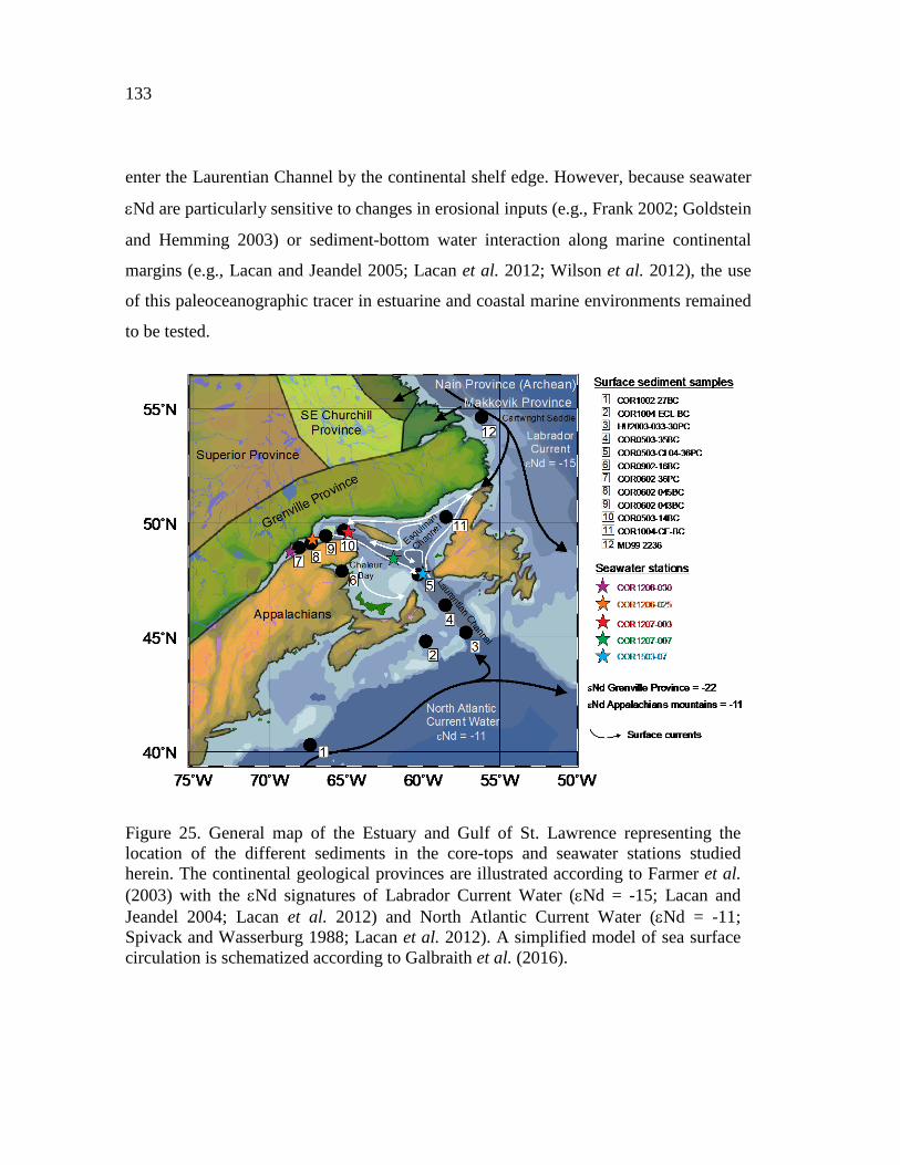
133
enter the Laurentian Channel by the continental shelf edge. However, because seawater
εNd are particularly sensitive to changes in erosional inputs (e.g., Frank 2002; Goldstein
and Hemming 2003) or sediment-bottom water interaction along marine continental
margins (e.g., Lacan and Jeandel 2005; Lacan et al. 2012; Wilson et al. 2012), the use
of this paleoceanographic tracer in estuarine and coastal marine environments remained
to be tested.
Figure 25. General map of the Estuary and Gulf of St. Lawrence representing the location of the different sediments in the core-tops and seawater stations studied herein. The continental geological provinces are illustrated according to Farmer et al. (2003) with the εNd signatures of Labrador Current Water (εNd = -15; Lacan and Jeandel 2004; Lacan et al. 2012) and North Atlantic Current Water (εNd = -11; Spivack and Wasserburg 1988; Lacan et al. 2012). A simplified model of sea surface circulation is schematized according to Galbraith et al. (2016).
134
In this context, we raised the question of whether the Nd isotope composition of
bottom seawater in the EGSL could be reliably obtained from the bulk sediments in
order to elucidate sources and bottom water mass mixing in this estuarine environment.
To resolve this query, we investigated and compared the concentrations in rare earth
elements (REEs) and the εNd and 87Sr/86Sr signatures from a set of seawater samples
and authigenic (leached Fe-Mn oxyhydroxides) and detrital fractions of bulk sediment
core-tops collected in the EGSL and continental shelf off southeastern Canada. To
corroborate the reliability of our leaching method (Chen et al. 2012), we examine REE
patterns and 87Sr/86Sr ratios to assess the absence of detrital contributions to the leaching
solutions and to support the seawater origin of the εNd signatures in the bulk sediment
leachates. In addition, detrital εNd, 87Sr/86Sr, and REE records of surface sediments are
used to identify different source areas and transport pathways of terrigenous material in
eastern Canada.
2.3. ENVIRONMENTAL SETTING
2.3.1. REGIONAL MORPHOLOGY AND GEOLOGICAL SETTING
The EGSL bathymetry is profoundly marked by the Laurentian Channel, a U-
shaped submarine valley resulting from Quaternary glacial erosion (Piper et al. 1990;
St-Onge et al. 2011). This dominant topographic feature (250–500 m deep) extends
from the eastern Canadian continental shelf to the mouth of the Saguenay Fjord near
Tadoussac (e.g., St-Onge et al. 2011). Two other U-shaped channels are also well
defined in the northeast Gulf: the Anticosti and Esquiman channels. Moreover, surface
sediments in the EGSL are characterized by fine-grained sediments (notably fine silts)
in the deep central parts of the Laurentian Channel and by coarser-grained sediments

135
(gravels, sands and, in lesser proportions, fine silts) in the slopes and adjacent shelves
(Loring and Nota 1973; St-Onge et al. 2003; Barletta et al. 2010; Pinet et al. 2011;
Jaegle 2015).
Two main geological provinces characterize southeastern Canada: (1) the
Canadian Shield in the northern part, typified by old silicate rocks (Paleo- to
Mesoproterozoic granites and gneisses) from the Grenville and Makkovik provinces
(Culshaw et al. 2000; Rivers et al. 2002; Farmer et al. 2003), (2) the Appalachian
Province in the southern part, composed of Paleozoic sedimentary rocks (including
shale, limestone, dolostone, and calcareous shale; Loring and Nota 1973). In this latter
province, Paleozoic carbonate rocks crop out mainly on Anticosti Island and the western
Newfoundland coast (Loring and Nota 1973; Ebbestad and Tapanila 2005).
Detrital sediments in the Gulf of St. Lawrence mainly derive from the Canadian
Maritime provinces and western Newfoundland coast, with the Grenvillian
metamorphic rocks of the Canadian Shield on the North Shore being a secondary source
(Loring and Nota 1973; Farmer et al. 2003; Jaegle 2015; Casse et al. 2017). Conversely,
in the lower St. Lawrence Estuary, detrital sediments are mainly supplied by the
Canadian Shield Province (Jaegle 2015; Casse et al. 2017). Sedimentary inputs from the
southern Labrador margin derive mainly from the Grenville and Makkovic provinces as
well as Hudson Strait and Baffin Bay (Farmer et al. 2003).
2.3.2. HYDROLOGICAL SETTING
Circulation in the EGSL is estuarine, with a lower-salinity surface layer flowing
seawards and saltier intermediate and deep layers flowing landwards (Koutitonsky and
Bugden 1991): (1) A thin, seaward-flowing surface layer (down to 50 m) has a
136
temperature of 2–10°C, salinity of 25–32‰, and originates from the mixing of seawater
with freshwater runoff from the Great Lakes, the St. Lawrence River, and the northern
Quebec drainage system; (2) a cold (-1 to 2°C) and saline (31.5–33 ‰) intermediate
layer (50–150 m), formed from the winter cooling of denser surface waters as tributary
flow decreases and ice forms; and (3) a warmer (3–6°C) and saltier (34–35 ‰)
landward-flowing bottom layer ( > 150 m deep) that originates from the edge of the
continental shelf through a mixture of cold, fresh, and oxygen-rich waters from the
LCW and warm, salty, and oxygen-poor NACW. In this bottom layer, the mixing
proportion between LCW and NACW varies on a decadal or secular time scale (e.g.,
Bugden 1991; Gilbert et al. 2005, 2007; Thibodeau et al. 2010; Sherwood et al. 2011).
Indeed, Gilbert et al. (2005) suggest a change in the relative proportion of LCW and
NACW in the water mass entering the Laurentian Channel from the 1930s to the 1980s.
Based on instrument temperature and salinity measurements of the LCW and the
NACW, these authors propose that the Laurentian Channel bottom waters were
composed of a LCW/NACW mixture of approximately 72% and 28% in the 1930s
compared to 53% and 47% in the 1980s, respectively.
Annual mean circulation in the EGSL is principally characterized by coastal
currents with a dominant E–W flow such as the Gaspé Current, the Anticosti Gyre, and
the inflowing West Newfoundland Current, which flows northward along the west coast
of Newfoundland (Figure 25). These currents are characterized by a mean speed on the
order of ~1 cm/s (Tang 1980). In the EGSL, one of the most striking features of near-
surface circulation is the Gaspé Current, which is a buoyancy-driven coastal jet
originating in the St. Lawrence Estuary (near Rimouski) and flowing seaward along the
coast of the Gaspé Peninsula (Sheng 2001) to finally exit the gulf through the Cabot
Strait. The tidal pulse from the Atlantic Ocean enters the Gulf of St. Lawrence from two
directions, through the Cabot Strait and the Strait of Belle Isle. Water mass circulation
through the Strait of Belle Isle is mainly characterized by a branch of the LC that flows

137
southwest along the Labrador coast into the Gulf of St. Lawrence (Figure 25). The
Cabot Strait represents a direct connection between the EGSL and the Northwest
Atlantic Ocean, where seawater masses passing through it are characterized by a mixing
of the NACW and the LCW (Gilbert et al. 2005). It can be underlined that in addition to
tidal pulse from the Atlantic Ocean, internal tides and waves can also be responsible for
sediment remobilization in the EGSL (e.g., Normandeau et al. 2014).
2.3.3. SEAWATER AND SEDIMENT εND AND 87SR/86SR VARIATIONS IN EASTERN CANADA AND ADJACENT CONTINENTAL SHELVES
The LCW water (which combines waters from the West Greenland Current and
from western Baffin Bay) is characterized today by low εNd with mean values ranging
between −15 and −14 around the tail of the Grand Banks of Newfoundland (Lacan and
Jeandel 2004; Lacan et al. 2012; Figure 25). Seawater from Baffin Bay reveals very
unradiogenic εNd values, dominated by Archean sources with εNd = -25 (Stordal and
Wasserburg 1986). Conversely, NACW waters (which originate in the temperate
Northwest Atlantic) are characterized by higher εNd values of −11 to −10.5 (Spivack
and Wasserburg 1988; Tachikawa et al. 1999b; Lacan et al. 2012; Figure 25).
In the eastern Canadian Shield, both glaciomarine sediments from the western
basin of Hudson Strait and Baffin Bay have very low εNd signatures with values
ranging between -28.1 to -28.9 and -23.1 to -27.2, respectively (Piepgras and
Wasseburg 1987; Farmer et al. 2003). The Precambrian crust of the North American
Shield is also characterized by a very low εNd signature (εNd = -32; Hollings et al.
2008; Innocent et al. 1997). Sediments originating from the Grenville Province have a
low Nd isotope ratio (εNd = -22; Farmer et al. 2003; Pratte et al. 2017; Figure 25) and a
large distribution of the Sr isotope composition, with a 87Sr/86Sr ratio of 0.7094–0.7746

138
(Millot 2002; Charlier et al. 2015). The Appalachian Province in the southern part of the
EGSL records a Panafrican Nd isotope signature (εNd ≈ -11; Hollings et al. 2008;
Figure 25) and 87Sr/86Sr values of 0.7103–0.7633 (van Breemen and Dallmeyer 1984;
Samson et al. 1995; Vinciguerra et al. 2016). Overall, as ɛNd and 87Sr/86Sr vary widely
according to the different geological provinces present in eastern Canada, we can use
sediment ɛNd and 87Sr/86Sr signatures to reconstruct sediment provenance changes in
the EGSL.
2.4. MATERIAL AND METHODS
2.4.1. SAMPLES
A total of 12 core-top sediment samples were collected at different depths in the
EGSL and adjacent continental shelves (Figure 25; Table 2) during several
oceanographic missions on board the R/V Coriolis II (COR-05, -06, -09 and -10) and
Marion Dufresne (MD99) as well as on the Canadian Coast Guard Ship Hudson
(HU2003). The sampling was performed using a box core (0.5 m x 0.5 m x 0.5 m),
gravity and piston core sampler wherein the uppermost 1 cm of sediment was recovered
in order to collect only the sediment-water interface. These core-top sediments were
found to represent modern time or at least the last decade/century in the case of the first
centimeters are missing.
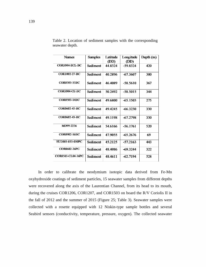
139
Table 2. Location of sediment samples with the corresponding seawater depth.
In order to calibrate the neodymium isotopic data derived from Fe-Mn
oxyhydroxide coatings of sediment particles, 15 seawater samples from different depths
were recovered along the axis of the Laurentian Channel, from its head to its mouth,
during the cruises COR1206, COR1207, and COR1503 on board the R/V Coriolis II in
the fall of 2012 and the summer of 2015 (Figure 25; Table 3). Seawater samples were
collected with a rosette equipped with 12 Niskin-type sample bottles and several
Seabird sensors (conductivity, temperature, pressure, oxygen). The collected seawater
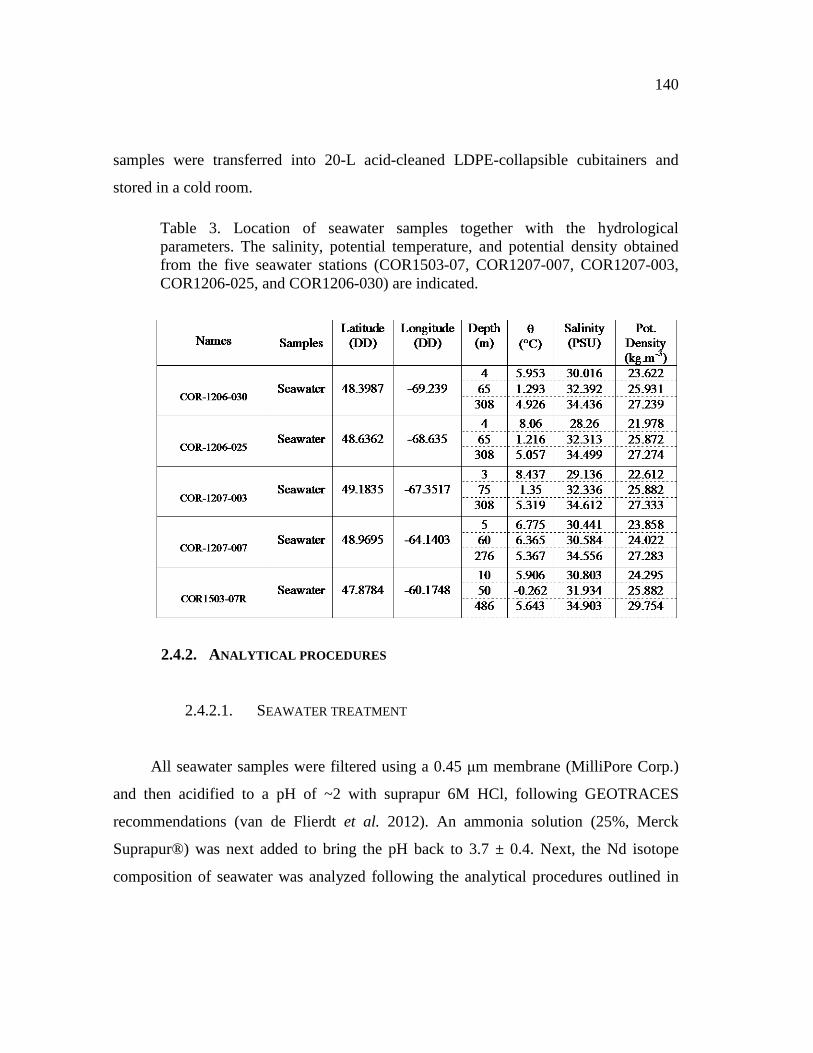
140
samples were transferred into 20-L acid-cleaned LDPE-collapsible cubitainers and
stored in a cold room.
Table 3. Location of seawater samples together with the hydrological parameters. The salinity, potential temperature, and potential density obtained from the five seawater stations (COR1503-07, COR1207-007, COR1207-003, COR1206-025, and COR1206-030) are indicated.
2.4.2. ANALYTICAL PROCEDURES
2.4.2.1. SEAWATER TREATMENT
All seawater samples were filtered using a 0.45 μm membrane (MilliPore Corp.)
and then acidified to a pH of ~2 with suprapur 6M HCl, following GEOTRACES
recommendations (van de Flierdt et al. 2012). An ammonia solution (25%, Merck
Suprapur®) was next added to bring the pH back to 3.7 ± 0.4. Next, the Nd isotope
composition of seawater was analyzed following the analytical procedures outlined in
141
Shabani et al. (1992) and Jeandel et al. (1998). Briefly, seawater REEs were
preconcentrated from seawater samples using a SEP-PAK Classic C18 cartridge loaded
with a HDEHP/H2MEHP [di(2-ethyl)hydrogen-phosphate and 2-ethylhexyldihydrogen-
phosphate] complexing agent. In order to destroy organic components, the pre-
concentrated REEs were then treated with 4.5 mL of aqua regia for at least 24 h at
110°C and subsequently evaporated. Samples were re-dissolved in 2 mL 7M HNO3, and
the solutions were divided into two aliquots of 1 mL for REE concentration and Nd-Sr
separation, respectively. In the aliquot for REE concentration analysis, 250 ng of Cd
was added as an internal standard. After evaporation almost to dryness, the residue was
dissolved in 1 mL of concentrated HNO3 and subsequently diluted with Milli-Q water to
a total volume of 5 mL. The aliquots for the Sr-Nd separation were evaporated to
dryness and re-dissolved in 2 mL of 2.5 M HCl before ion exchange chemistry.
2.4.2.2. BULK SEDIMENT LEACHING
Seawater Nd and Sr isotope signatures from authigenic Fe-Mn coatings of the
bulk sediment were extracted applying the leaching protocol of Chen et al. (2012).
Briefly, 200 mg of dried and powdered sediment were rinsed three times with Milli-Q
water. Next, Sr and Nd contained in the sediment oxyhydroxide fraction were leached
for about 30 min in a single step using a dilute reducing and complexing solution
consisting of 0.005M hydroxylamine hydrochloride (HH), 1.5% acetic acid, and 0.03M
Na-EDTA, buffered to pH 4 with suprapur NaOH. A buffered acetic acid leach step was
omitted since biogenic carbonates are negligible in all sediment samples (Casse et al.
2017). During treatment, the sediment samples were gently shaken to enhance the
reaction. After centrifugation, the leach solution was decanted, evaporated, and re-
dissolved in 2 mL of 2.5 M HCl This last solution was divided into two aliquots of 1
142
mL, one for the REE concentration analyses and the other one for the Nd and Sr
chromatographic extraction. In the aliquot for REE concentration analysis, 250 ng of Cd
is added as an internal standard. After evaporation almost to dryness, the residue is re-
dissolved in 1 mL of concentrated HNO3 and subsequently diluted with Milli-Q water to
a total volume of 5 mL.
2.4.2.3. BULK SEDIMENT DIGESTION (DETRITAL FRACTION)
In order to assess the different sources of the detrital particles, the previously
leached sediments were leached again for about 24 h with a stronger leaching solution
(0.05 M HH) to ensure complete removal of residual Fe-Mn oxyhydroxides.
Approximately 200 mg of powder sediment samples were weighed into 100 mL
microwave PTFE vessels. Next, a mixture of concentrated HNO3/HF/HCLO4 (1:6:1
mL; Optima™ grade) was added to break down aluminosilicates. Samples were run in a
microwave for 10 min at 175°C and 30 min at 220°C. Samples were left to cool and
transferred to 30 ml Savillex® PFA Teflon® beakers. To minimize sample loss by
adsorption onto the microwave vessels, the interior of each vial was rinsed with about 2
mL of HNO3. Beakers were heated at 120°C to reduce solution volume to incipient
desiccation. Subsequently, 1 mL of concentrated HNO3 and 4 mL of concentrated H2O2
(Optima™ grade) were added to remove remaining organic matter from the solution.
Samples were dried once more at 120°C and re-dissolved in 3 mL of 6M HCl. This
solution was again dried at 120°C. Samples were finally re-dissolved in 2.2 mL of 2.5M
HCl. The solution was divided into two aliquots of 1 mL, one for the REE concentration
analyses and the other one for the Nd and Sr chromatographic extraction. In the aliquot
for REE concentration analysis, 250 ng of Cd is added as an internal standard. After
143
evaporation almost to dryness, the residue is re-dissolved in 1 mL of concentrated
HNO3 and subsequently diluted with Milli-Q water to a total volume of 5 mL.
2.4.2.4. COLUMN CHEMISTRY: SR AND ND SEPARATION
Sr and Nd are separated from other elements applying a single-step ion
chromatographic separation (Li et al. 2014). Briefly, solutions obtained from previous
steps (seawater, leaching, and detrital fraction) were centrifuged at 5000 rpm for 8 min.
Then, 1 mL of the supernatant solution was passed through a two-layered mixed resin
column (70 mm length, 6 mm diameter) with the upper layer containing 1.5 mL of
Biorad® AG50W-X12 (200–400 mesh) resin and the bottom layer containing 0.45 mL
of Eichrom® LN Spec resin (100–150 μm). Before sample loading for separation of Sr–
Nd from the sample matrix, the mixed resin column was pre-washed with 18 mL of 6 M
HCl, 8 mL of 3 M HF, and 4 mL of H2O in turn. After sample loading and rinsing four
times with 0.5 mL of 2.5 M HCl, the column was washed with 13.5 mL of 2.5 M HCl.
Most matrix elements (K, Ca, Na, Mg, Al, Fe, Mn, Ti) and Rb were removed during this
step. Then, the Sr fraction was stripped with 5.5 mL of 2.5 M HCl. Some of the HREEs
(Dy, Ho, Er, Tm, Yb, Lu) and Ba were then washed out with 3 mL of 2.5 M HCl. Next,
Nd was then isolated from other REEs with 8 mL of 6 M HCl. Sr and Nd fractions were
heated on a hotplate at 120°C to dryness and prepared for isotope measurements.
2.4.2.5. REE CONCENTRATIONS AND SR-ND ANALYSIS
REE concentrations are determined using an inductively coupled plasma-
quadrupole mass spectrometer (ICP-QMS Agilent 7500c) at ISMER. Due to isobaric

144
interference, Eu concentrations are corrected for the residual presence of Ba-generating
oxides at masses 151 and 153, and Gd concentrations, taking into account the influence
of Pr oxides (about 2%). Procedural blanks always account for less than 1% of the
lowest concentration measured in the samples. Analytical accuracy and precision are
better than 5% for all REE, as checked by international standards and analysis of
replicate samples. REE are normalized to Post Archaean Australian Shale (PAAS,
Pourmand et al. 2012) in order to evaluate the REE patterns as given in Martin et al.
(2010) and Du et al. (2016). Fractionation between light REE (LREE: La–Nd), medium
REE (MREE: Sm–Dy), and heavy REE (HREE: Ho–Lu) was investigated using the
following indices: HREE/LREE ratio (Tm+Yb+Lu)/(La+Ce+Pr+Nd) and MREE*
(2[Gd+Tb+Dy]/[HREE+LREE]). Additionally, we calculated the distribution of the Ce-
anomaly Ce/Ce* [Ce/Ce* = 2*Cen/((Lan + Prn)] to study dissolved/particulate
interactions in seawater and especially for identifying lithogenic inputs (Elderfield,
1988; Tachikawa et al., 1999b). The vertical distribution of Nd and LREE-HREE
concentrations through the seawater column has been examined to investigate the main
seawater process controlling their distribution in the EGSL.
Sr isotope ratios (88Sr/86Sr) were measured in dynamic mode on a Thermo
Scientific Triton Plus™ multicollector thermal ionization mass spectrometer (TIMS) at
GEOTOP (Montreal, Canada). Sr samples were loaded and analyzed on a single Re
center filament. The mass bias is corrected using a 86Sr/88Sr ratio of 0.1194, assuming
exponential fractionation behavior. Repeated analyses of the NIST-987 standard yield
values of 0.71026 (± 0.00001, 2σ reproducibility). This mean value compares well to its
certified value of 0.710248 ± 0.000010 (Weis et al., 2006). The total procedural blanks
for Sr was less than 0.5 ng, which is considered negligible compared to the sample
yields (>100 ng).

145
Neodymium isotope ratios (146Nd/144Nd) are analyzed on a Nu Instruments Multi-
Collector Inductively Coupled Plasma Mass Spectrometer (MC-ICP-MS), also at
GEOTOP. The mass-bias correction is performed by normalizing 146Nd/144Nd to 0.7219
and applying an exponential-fractionation correction. The long-term precision of this
instrument is ensured by analyses of the JNdi-1 standard (143Nd/144Nd = 0.512114 +/-
0.000010; n=13). The results are normalized to the accepted 143Nd/144Nd of 0.512115
for the JNdi-1 standard (Tanaka et al. 2000). 143Nd/144Nd isotope ratios are expressed as
follows: εNd = ([(143Nd/144Nd)sample/(143Nd/144Nd)CHUR]-1)x10000 (CHUR:
Chrondritic Uniform Reservoir; Jacobsen and Wasserburg 1980). External
reproducibility (2σ) of repeated JNdi-1 standard measurements is between 0.3 and 0.6
εNd units. The blank has an internal 144Nd signal of 0.2 V compared to 3 V for the other
samples, which represent only 7% of the global sample intensity. Overall, the total
procedural blanks are negligible compared to Nd extracted from seawater, leachates,
and detrital sediments.
All analytical data presented are available in the annexes (Annexs 3 to 4).
2.5. RESULTS
2.5.1. SEAWATER PHYSICAL PROPERTIES
Potential temperature, salinity, and potential density results from five seawater
stations (COR1503-07, COR1207-007, COR1207-003, COR1206-025, COR1206-030)
are illustrated in Figure 26. The salinity versus potential temperature (Figure 26A) and
salinity versus potential density (Figure 26B) allow the identification of similar water
masses at the five stations. In the surface layer, the five stations have low salinity (28.2–
31.5 psu), high temperature (3–9°C), and low potential density (21.9–25.5‰). The

146
intermediate layer has a salinity of 31.5–33.0 psu, a cold temperature of -1.0–2.5°C, and
a potential density of 25.5–26.5 kg/m3. The deep layer records the highest salinity
(34.0–35.0 psu), a high temperature (4.0–6.7°C), and a high potential density (27.0–29.8
kg/m3).
Figure 26. (A) Salinity versus potential temperature and (B) Salinity versus potential density obtained from the five seawater stations (COR1503-07, COR1207-007, COR1207-003, COR1206-025, and COR1206-030).
2.5.2. RARE EARTH ELEMENT CONCENTRATIONS
Nd concentrations from seawater, leached bulk sediment, and detrital samples
analyzed range from 1.0 to 6.7 pmol/kg (Figure 27A), 4.6 to 235.4 ng/g, and 1.24 to
2.64 μg/g, respectively (Annexe 3). All the REE concentrations are presented in annexe
3. All the seawater stations show a decrease in Nd concentrations from the surface to the
deeper layer (Figure 27A). Nd concentrations for seawater stations COR1207-003,
COR1206-025, and COR1206-030 decrease from 2.1 to 0.4 pmol/kg, 3.9 to 1.3
pmol/kg, and 1.4 to 0.3 pmol/kg, respectively. Nd concentrations from station

147
COR1207-007 present the largest decrease, from 6.7 pmol/kg for the upper layer to 2.3
pmol/kg for the deeper layer. Seawater station COR1503-07 (the one closest to the
mouth) records a lower decrease in Nd concentrations with data of 1.0 to 0.4 pmol/kg.
PAAS-normalized REE patterns of most seawater samples are quite similar and have a
negative cerium anomaly (Figure 28A), which is a similar pattern to other published
seawater REE patterns (e.g., Piepgras and Jacobsen 1992; Lacan and Jeandel 2001;
Jeandel et al. 2013; Grenier et al. 2013; Tostevin et al. 2016; Filippova et al. 2017). The
negative cerium anomaly is generally more pronounced for the deeper seawater samples
compared to the surface and intermediate depths, although this anomaly is less
pronounced for stations COR1206-025 (305 m) and COR1207-007 (60 m). For stations
closest to the lower estuary (COR1207-003, COR1206-030, and COR1206-025), the
Ce/Ce* ratio increases from 0.08 to 0.16, from 0.16 to 0.18, and from 0.31 to 0.92
between the surface and the deeper layer, respectively (Figure 27B). For the stations
closest to the mouth (COR1503-07 and COR1207-007), the Ce/Ce* ratio decreases
continuously from the surface to the bottom, with values dropping from 0.36 to 0.17 and
from 0.71 to 0.61, respectively. As a whole, the LREE/HREE ratio follows the same
trend as the Ce/Ce* ratio. The seawater station from the gulf (COR1503-07) has a heavy
versus light REE enrichment, with LREE/HREE of < 0.4 throughout the water column
(Figure 27C). Seawater stations COR1206-030 and COR1206-025 from the estuary
have many variations in the LREE/HREE ratio. In seawater station COR1206-030, the
LREE/HREE increases from 1.4 in the surface layer to 2.3 in the intermediate layer, but
decreases to 0.2 in the deeper layer. Similarly, the LREE/HREE ratio from seawater
station COR1206-025 increases from 0.7 in the surface layer to 3.2 in the intermediate
layer, to finally decrease to 1.0 in the bottom. Station COR1207-007 follows the same
trend, with the LREE/HREE increasing from 0.8 to 1.7 in the intermediate layer, and
decreasing in the deeper layer to reach 0.4. Only station COR1207-003 increases
continuously from 0.6 to 1.6 from the surface to the bottom.

148
Figure 27. Distribution of (A) Nd concentrations, (B) Ce/Ce* (Ce/Ce* = 2[Ce]n /([La]n + [Pr]n), and (C) LREE/HREE ratio obtained from the five seawater stations. (D) Vertical distribution of suspended particulate matter from the Gulf (station 39; Sundby, 1974) and Estuary of St. Lawrence (station 38 from Yeats et al., 1979; stations F1 and EM4 from Neumeier, personal communication 2017). (E) Vertical distribution of the salinity obtained from the five seawater stations.
PAAS-normalized REE of bulk sediment leachates reveal an “MREE bulge” type
pattern, with an MREE enrichment compared to the HREE and LREE and no negative
Ce anomalies (Figure 28B). This MREE bulge enrichment is more pronounced on the
sediment sample from Chaleur Bay (COR0902-16BC). PAAS-normalized REE patterns
of the detrital sediment samples are characterized by slight MREE enrichment over
LREE and progressive HREE depletion (Figure 28C). Detrital REE signatures reveal a
slight enrichment in LREE and MREE over HREE evidenced by the La/Yb and Gd/Yb
ratios. Sediments from the Labrador Shelf (MD9922-36) have the highest LREE and
MREE enrichment (La/Yb = 1.77, Gd/Yb = 1.46). Sediments from the Laurentian and
Esquiman Channel have higher La/Yb ratios (∼1.23 to 1.53) than sediments from the
shelf (La/Yb ∼ 0.95 to 1.19). Similarly, the Gd/Yb ratio is higher for sediments close to

149
the North Shore (from 1.23 to 1.39) compared to sediments from the South Shore and
south of the continental shelf (Gd/Yb ∼ 1.01–1.16).
Figure 28. (A) REE patterns normalized to PAAS at the different depths of the five stations. (B) REE patterns normalized to PAAS for the leachate sediment samples. (C) REE patterns normalized to PAAS for the detrital sediment samples.
2.5.3. STRONTIUM ISOTOPE SIGNATURES
87Sr/86Sr values obtained on seawater samples range between 0.70915 and
0.70937 (Annexe 4), which is characteristic of present-day seawater mass (0.709211 ±
37; Elderfields 1986; Winter et al. 1997). The 87Sr/86Sr values obtained from bulk-
sediment leachates range between 0.70975 and 0.70870 (average 0.70922). The detrital
sediment samples reveal higher 87Sr/86Sr values, ranging between 0.71475 and 0.73062
(average 87Sr/86Sr = 0.72349).

150
2.5.4. NEODYMIUM ISOTOPE SIGNATURES
The εNd values obtained on seawater mass are unradiogenic, ranging between -
18.9 ± 0.35 and -21.7 ± 0.35 (Annexe 4; Figure 29). There are no significant differences
between the εNd values of seawater stations collected in autumn (COR1207-007,
COR1207-003, COR1206-025, COR1206-030) compared to the one taken in summer
(COR1503-07), with an average of εNd = -19.40 ± 0.51 and εNd=-20.24 ± 0.53,
respectively. The vertical distribution of εNd seawater values from the COR1206-030
and COR1503-07 stations shows a slight decrease from -18.88 and -19.77 for the upper
layers to -20.86 and -20.50 in the deep layer, respectively. Conversely, the εNd from
seawater station COR1207-003 increases slightly from -21.69 to -20.10 between the
surface and bottom layers. The εNd values for station COR1206-025 are almost
homogeneous throughout the water column, with very similar values between the
surface (εNd = -18.41) and the bottom (εNd = -18.23). The only εNd value obtained for
station COR1207-007 is slightly more radiogenic (εNd = -17.27) than those of other
stations.
The εNd values from bulk sediment leachates range between -16.12 ± 0.18
(Chaleur Bay) and -27.18 ± 0.23 (southern Labrador Shelf) (Annexe 4; Figure 30A).
Leached samples from the lower estuary have unradiogenic εNd signatures with values
ranging between -19.27 ± 0.43 and -21.02 ± 0.31, with a mean value of -19.54 ± 0.24.
Samples from the mouth and continental shelves record slightly more radiogenic εNd
values ranging between -16.12 ± 0.18 and -19.35 ± 0.19 (average -17.95 ± 0.36). εNd
obtained on the detrital sediment samples range between -14.30 ± 0.13 (Chaleur Bay)
and -28.72 ± 0.17 (southern Labrador Shelf), with a mean value of -18.69 ± 0.16 (
Figure 30B). εNd signatures from the estuary range between -18.71 ± 0.12 and -21.83 ±
0.12, with a mean value of -20.41 ± 0.14. Detrital εNd from the mouth and the
continental shelves are more radiogenic, with values ranging from -14.29 ± 0.13 to -

151
15.96 ± 0.23 (average -15.20 ± 0.17). We can note that a good correlation is observed
between the εNd values obtained on detritic sediment samples and authigenic sediment
samples (Figure 31).
Figure 29. Vertical profiles of εNd values at the five seawater stations along a W-E salinity transect from the EGSL.
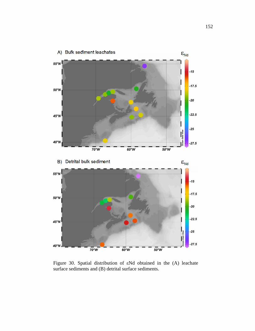
152
Figure 30. Spatial distribution of εNd obtained in the (A) leachate surface sediments and (B) detrital surface sediments.

153
Figure 31. εNd detritic vs εNd obtained on leachate sediment. The Appalachian area is composed by the surface sediments obtained on the cores COR0902-16BC, COR0503-CL03-35BC, 2003-033-030PC, COR1004-ECL-BC and COR1002-27B. The Grenville Province area is composed by the surface sediments obtained on the cores COR0503HONOI-14BC, COR1004-CE-BC, COR-0602-043-BC and COR0602-045BC. The Baffin Bay area is defined by the sediment sample MD99-2236.
2.6. DISCUSSION
PAAS-normalized REE patterns and Nd-Sr isotope variations observed in our
seawater, bulk sediment leachates, and detrital samples are discussed in terms of
changes in local water sources, particle scavenging, continental input, and sediment
provenance.

154
2.6.1. RELIABLE EXTRACTION OF THE SEAWATER SIGNAL: SEAWATER VERSUS BULK SEDIMENT LEACHATES
Due to the high detrital influence in estuarine and coastal marine environments,
the Nd isotope composition of local seawater can deviate from that of a true seawater
signal. Therefore, prior to interpreting Nd isotope signatures of bulk sediment leachates
from the EGSL in terms of sources and mixing of water masses, an evaluation of the
reliability of this extraction method is crucial. We therefore compared the REEs and
Nd-Sr isotope signature extract of bulk sediment leachates to the signatures of the
overlying water column and of the detrital fraction in order to evaluate the reliability of
bulk sediment leachates as recorders of bottom-water Nd isotope composition.
2.6.1.1. VERTICAL DISTRIBUTION OF REES THROUGHOUT THE SEAWATER COLUMN
The REE patterns of most of our seawater samples show a negative Ce-anomaly
together with slight enrichment of heavy REE (Figure 28A). Such a pattern is consistent
with oceanic REE trends (e.g., Piepgras and Jacobsen 1992), characterized by poor Ce
solubility due to its specific redox properties and its oxidative state (IV) compared to the
other trivalent REEs (Jeandel et al. 2013).
For seawater stations COR1503-07 and COR1207-007 (gulf stations), the Ce/Ce*
ratio decreases from the surface to the bottom, reflecting a typical seawater trend
(Figure 27B). Ce/Ce* ratios from the seawater stations from the lower estuary
(COR1206-025, COR1207-003, COR1206-030) increase from the surface to the
bottom, probably due to particles settling down through the water column (Figure 27D).

155
This assumption is supported by the larger amount of suspended particulate matter
(SPM) in the lower estuary compare to the gulf (Figure 27D). Moreover, because REEs
have a relatively gradual decrease in ionic size with increasing atomic number, several
chemistry processes (such as adsorption or scavenging) can cause fractioning between
LREE and HREE (Elderfield et al. 1988; Lacan and Jeandel 2004; Jeandel et al. 2013;
Garcia-Solsona et al. 2014). The HREEs form stronger complexes with ligands like
CO32- or OH- in solution (Bau and Möller 1992) compared to the LREEs, which are
less soluble in seawater and are preferentially adsorbed at particle surfaces in adsorption
reactions (Elderfield 1990). The relatively light enrichment in HREE of our seawater
samples suggests that the EGSL water column is influenced by higher lithogenic inputs.
Only seawater stations COR1503-07 and COR1207-007 (which are the closest to the
mouth) have Ce/Ce* and LREE/HREE ratios characteristic of seawater trends (Figure
27B-C). For the two seawater stations near the lower estuary (COR1206-025 and
COR1206-030), the LREE/HREE ratio varies widely through the water column,
reflecting greater fractionation between REEs due to higher particle contents in the
estuarine area (Figure 27A, D). Indeed, increasing SPM concentrations from the gulf
toward the estuary have been noted in the surface layer (Sundby 1974). This observation
is in agreement with previous studies on shallow environments that suggest that
seawater REE patterns in these areas display relatively flat patterns and strong
interactions with suspended particulate matter (Jeandel et al. 2013; Wu et al. 2015).
The decrease in Nd concentrations throughout the water column is well correlated
with the evolution of suspended particle contents in the EGSL (Figure 27A, D).
Significant riverine influence can be readily observed in the surface water from the
estuary and gulf in the form of decreased salinity (Figure 26; Figure 27E). Many factors
(e.g. tidal and non-tidal circulation, basin geology, bathymetry, flocculation, size and
specific gravity of particles, organic productivity, wind, and seasonal climate
variability) can control SPM distribution (D'anglejan and Smith 1973) in the EGSL,
156
thus accounting for the high variability in distribution in the different estuary stations
(38, F1, EM4; Figure 27D). Both the high Nd and SPM concentrations (0.10 to 2.9
mg/L; Sunbdy 1974) in the St. Lawrence Estuary are linked to the high riverine
discharge. According to Sundy (1974), the highest SPM concentrations in the gulf are
associated with water that flows seaward from the estuary along the shore of the Gaspé
Peninsula (Figure 25). Similarly, Figure 27A reveals that the nearest seawater station to
the Gaspé Peninsula (COR1207-007) records the highest Nd concentrations, probably
due to the proximity with the Gaspé current which is the predominant surface current in
the EGSL (Sheng 2001; Casse et al. 2017). Low SPM concentrations occur in the
intermediate layer (0.05–0.1 mg/L; Sundby 1974) and bottom layer (0.1–0.4 mg/L;
Sundby 1974). This decrease is well correlated with low Nd concentrations through the
intermediate and deeper layers, with the lowest concentrations near the bottom. These
low SPM concentrations are related to seawater entering from the Atlantic Ocean into
the Gulf of St. Lawrence through the Cabot Strait. Overall, because of the open ocean
seawater origin, there is lower variability in the SPM concentrations in the intermediate
and bottom waters of the EGSL compared to the surface water. Therefore, we
hypothesize that the deep-water Nd depletion is principally caused by the adsorption of
LREEs into suspended matter. Indeed, suspended matter plays a key role in the
scavenging of particle-reactive elements (Tachikawa et al. 1999b). Throughout the
water column, suspended matter adsorbs dissolved REEs, and then these suspensions
are removed from the water column to be assimilated into large sinking aggregates. The
strong relationship between the vertical distribution of Nd and SPM concentrations
suggests that scavenging processes control the behavior of REE elements in the EGSL.
The hypothesis of setting the dissolved Nd into organic particles can be excluded
because the contribution from biological production of the total suspended material in
the EGSL is low, representing only a small fraction of the total (D'anglejan and Smith
1973; Sundby 1974; Barth et al. 1998). Indeed, the total SPM is 60% to more than 90%

157
inorganic by weight (essentially composed of illites and chlorites), with a mean particle
size of 5–7 μm (D'anglejan and Smith 1973).
2.6.1.2. DISTRIBUTION OF REES IN LEACHATE BULK SEDIMENT SAMPLES
The PAAS-normalized REE plot of the bulk sediment leachates shows significant
MREE enrichment (Figure 28B), which is not evident for the seawater (Figure 28A) and
detrital sediment samples (Figure 28C). This MREE enrichment, essentially similar to
marine pore water REE patterns, is probably due to the reduction of particulate Fe3+
oxides, which preferentially release incorporated MREE under reducing conditions
(e.g., Haley et al. 2004; Martin et al. 2010; Molina-Kescher et al. 2014, and references
therein). Alternatively, we cannot rule out that other sedimentary processes such as
riverine input of oxide sediment coatings or remineralization of organic matter (Bayon
et al. 2004; Freslon et al. 2014) could account for this MREE bulge. In estuarine and
coastal marine environments, Nd signals are more variable due to Nd input from local
river sources, which may well include preformed signals from riverine-based metal
oxide sediment coatings (Bayon et al. 2004; Kraft et al. 2013). These riverine oxide
sediment coatings also show MREE bulges (Bayon et al. 2004). However, given that
the present-day seawater in the EGSL shows no MREE enrichment, it is more likely
that the MREE bulge in the bulk sediment leachates does not result from riverine input
to seawater. Furthermore, although this enrichment could also be caused by the
dissolution of phosphates, such as authigenic apatite (Hannigan and Sholkovitz 2001),
in this case we must reject this possibility because apatite appears to be negligible in
surface sediment samples from the main rivers that feed the EGSL, as suggested by its
absence in the bulk sediment XRD diffractograms (Jaegle 2015; Casse et al. 2017).
Likewise, the remineralization of organic compounds in marine sediments could also

158
explain (at least partly) the REE distribution in pore waters (Bayon et al. 2014).
However, since we do not use the specific reagents that target the organic fraction (e.g.,
Bayon et al. 2014; Freslon et al. 2014), we cannot consider their contribution to
sediment leachate Nd. Moreover, even if the organic matter presents a typical MREE
‘bulge’ profile, the dissolution of organic compounds during the leaching processes also
releases LREE, leading to a REE shape pattern 10 time more LREE-enriched (Freslon et
al. 2014) than our sediment leachates. As our sediment leachates are not characterized
by a similar LREE enrichment, we proposed that sedimentary organic matter is not a
significant source of the MREE enrichment in our samples.
2.6.1.3. DISSOLVED-PARTICULATE INTERACTIONS OF REES
In the HREE/LREE - MREE* crossplots (Figure 31), most of our seawater
samples and bulk sediment leachates plot along the mixing line (authigenic-pore water
array) between the most MREE-enriched leachates (Gutjahr et al. 2010) and the most
HREE-enriched oxic pore water (Haley et al. 2004). These results support the idea that
authigenic Fe–Mn oxyhydroxide coatings dominate the Nd signal in our bulk sediment
leachates. On the other hand, REE data from detrital sediments fall in the detrital zone
(Figure 31). Here, all our detrital sediment samples are characteristic of continental
crustal materials similar to PAAS end-members. Some surface and subsurface seawater
samples (COR1207-003-3m, COR1207-003-75m, COR1207-003-308m, COR1206-
030-4m, COR1206-030-65, COR1207-007-5m, COR1207-007-60m, COR1206-025-
4m, COR1206-025-65m, and COR1206-025-305m) are also close to this detrital zone.
Because the stations of these seawater samples are close to the continental margin, we
suppose that boundary-exchange processes could disturb the initial seawater signal (e.g.,
Wilson et al. 2003). Moreover, most of these seawater stations are close to the surface

159
(< 100 m depth), which is consistent with a higher SPM content in the seawater (Figure
27D). On the other hand, the closest seawater station to Cabot Strait (COR1503-07)
recorded the highest HREE/LREE ratio, probably due to the influence of more oceanic
water masses, which are less laden with suspended particulate matter. Most of the
deepest seawater stations (COR1503-07-485m, COR1206-030-308m, and COR1207-
007-276m) also have a higher HREE/LREE ratio, which is characteristic of
conventional seawater behavior.
Figure 32. Comparison of HREE/LREE vs. MREE* crossplots (Du et al. 2016) obtained from seawater samples, and authigenic and detrital sediment samples. A mixing line between the most HREE-enriched oxic pore waters (Haley et al. 2004) and the most MREE-enriched leachates (Gutjahr et al. 2010) reflects the ‘‘authigenic-pore water array” (dashed line).

160
2.6.1.4. STRONTIUM AND NEODYMIUM ISOTOPE SIGNATURES
The 2.4 Myr residence time of Sr in seawater is long compared to the mixing time
of the oceans (500–1000 years; Tachikawa et al. 2003), causing a globally uniform 87Sr/86Sr ratio of seawater and modern marine carbonates (87Sr/86Sr ∼0.70918; Palmer
and Elderfield 1985; Veizer 1989; Henderson et al. 1994) over timescales of ~50 ka,
even in relatively enclosed ocean basins (Winter et al. 1997). Consequently, both the 87Sr/86Sr values of modern seawater and leachate sediment in the EGSL (~0.70924 ±
0.00005) are close to the global seawater value. This observation is especially relevant
in the EGSL, where biogenic sources of carbonates are negligible (less than 1%; Jaegle
2015; Casse et al. 2017) and detrital sediments typically have highly elevated 87Sr/86Sr
values (0.71475 to 0.73062).
The CTD profile of seawater stations from the Laurentian Channel shows three
distinctive water mass layers (Figure 26), with a seawater surface layer characterized by
low salinity and high temperature, a cold intermediate layer, and a warm and salty deep
water layer (which represents mixing between the LCW and NACW). Despite this
pronounced stratification, the vertical distribution of εNd from all seawater stations
shows unradiogenic Nd isotope signatures in the entire water column (-18.9 ± 0.35 and -
21.7 ± 0.35; Figure 29), implying that particle scavenging and downward transport
processes within the water column play a significant role (Jeandel et al. 2007; Stichel et
al. 2012, 2015; Van de Flierdt et al. 2016). Dissolved lanthanide concentrations are
about 10 times higher in estuaries than in coastal seawater or open-ocean waters
(Elderfield et al. 1990). This reflects intense scavenging of REE in estuarine
environments (about 90%), which is usually explained by adsorption onto suspended
detrital particles (Sholkovitz and Szymczak 2000; Freslon et al. 2014). Because water

161
depth in the EGSL is quite low (<500 m), we hypothesize that suspended particles settle
quickly from the surface to the bottom and the Nd isotope fractionation remains the
same throughout the water column. Consequently, the dissolved Nd isotope signatures
in the EGSL are almost homogeneous from the surface to the bottom and depend on
both the scavenging processes and the Nd inputs from the surrounding geological
provinces (ɛNd Canadian Shield ~ -22, εNd Appalachian ~ -11; Farmer et al. 2003;
Hollings et al. 2008; Pratte et al. 2017). Moreover, the EGSL is considered a sub-arctic
region, with air temperatures below zero celsius during the winter, allowing the
formation of sea ice (Saucier 2003; de Vernal et al. 2011). Thus, brine rejection
resulting from sea ice formation may play a significant role in the distribution of the
homogeneous Nd isotope composition in EGSL seawater (Haley and Polyak 2013;
Haley et al. 2008a). Indeed, the flow from the surface to the bottom of the substantially
dense brines may homogenize the Nd isotope composition through the seawater column.
According to Ivanov et al. (2004), dense water overflow off continental shelves
(cascading) originating from cooling or salinization is one of the contributing processes
of deep-shelf ocean material transfer. Similar observations have been reported by
Porcelli et al. (2009) and Haley and Polyak (2013) in the Arctic Ocean.
As for the seawater samples, the authigenic εNd values obtained on bulk sediment
leachates is unradiogenic, with values ranging between -16.12 ± 0.18 (Chaleur Bay) and
-27.18 ± 0.23 (Labrador Shelf), with an average of -19.38 ± 0.30 (Figure 30A). These
εNd values are very unradiogenic compared to the actual εNd values of LCW (εNd ~ -
15; Lacan and Jeandel 2004; Lacan et al. 2012) and NACW (εNd ~ -11; Piepgras and
Wasserburg 1987; Lacan et al. 2012). According to Frank (2002), one of the most
important sources for the dissolved Nd budget of water masses is riverine input,
although most of the dissolved Nd river load is precipitated to form oxyhydroxides in
estuarine sediments (Goldstein and Jacobsen 1988; Elderfield et al. 1990; Ingri et al.
2000). The authigenic εNd signal in the EGSL therefore likely represents mainly the
162
unradiogenic εNd detrital signatures resulting from the erosion of the Grenvillian
metamorphic rocks of the Canadian Shield (εNd ~ -22; Farmer et al. 2003; Pratte et al.
2017) and, to a lesser extent, from the early Paleozoic sedimentary rocks of the
Appalachian domain on the South Shore, Canadian Maritime Provinces, and western
Newfoundland coast (εNd ~ -11; Hollings et al. 2008). Indeed, taking into consideration
the εNd values of the Grenville Province and Appalachian Province and using a
conservative binary mixing, we can estimate that seawater εNd signatures in EGSL
reflect a mixture of approximately 74% from the Canadian Shield and 26% from the
Appalachian domain (Figure 32). These figures are in agreement with other estimates
from EGSL sediments based on bulk mineralogical data (Jaegle 2015). However, we
cannot rule out that the LCW/NACW εNd signatures are represented in our authigenic
εNd signal. Given the high river discharges and detrital influence in the EGSL, we
suggest that the LCW/NACW signal recorded in the EGSL bottom sediments is masked
by the εNd signatures of continental river inputs. Consequently, Nd inputs from the
EGSL to North Atlantic surface waters may thus imprinting an unradiogenic Nd
isotopic composition to the Inner Labrador Current as well as the North Atlantic
Current.
The εNd obtained from surface leached sediments closest to the North Shore
(COR0602-043BC, COR1004-CE-BC, COR0503-HONOI-14BC, and COR0602-
045BC) have a higher concentration of εNd (~83%) from the Grenville Province
compared to sediments from the shelves (HU2003-033-30PC, COR0503-CL03-35BC,
COR1004-ECL-BC, COR0902-16BC, and COR1002-27BC), which have higher
amounts of εNd (~64%) from the Appalachian domain (Figure 32). Therefore, the
authigenic εNd signal obtained in the EGSL cannot be used to track water mass
provenance and mixing, but instead reflects the composition of the surrounding
continental margins. Overall, these results suggest that Nd isotopes may further be used
to understand changes in continental weathering regimes over time. Because the detrital

163
Nd isotopic composition presents a wider range of εNd values, it is used to discriminate
the origin of sediment sources.
Figure 33. Relative contribution of Appalachian source vs. the North American Shield. The relative percentages were calculated with the Nd isotope composition from the North American Shield (143Nd/144Nd = 0.51105 ; Innocent et al. 1997) and

164
Appalachian sources (143Nd/144Nd = 0.512045 ; Fagel and Hilaire Marcel 2006) according to 143Nd/144Nd(%Grenville-Prov)=[[( 143Nd/144Ndsample) – (0.512045-0.51105)]/ (0.512045-0.51105)]*100.
2.6.2. SEDIMENT PROVENANCE
2.6.2.1. DETRITAL REE PATTERNS
PAAS-normalized REE patterns of detrital sediments can provide important clues
on source-rock characteristics (e.g., Hoskin and Ireland 2000; Montero-Serrano et al.
2009; Armstrong-Altrin et al. 2013, 2016; Osborne et al. 2015). Indeed, higher
LREE/HREE ratios, MREE enrichment (MREE/MREE*), and the occurrence of
positive Eu anomalies (Figure 28C) are characteristic of sediments derived mainly from
igneous/metamorphic sources (Bayon et al. 2015). According to Eade and Fahrig (1971)
and Shaw et al. (1976, 1986), Canadian Shield composites are enriched in LREE
relative to HREE. In contrast, sedimentary rocks from the Appalachians are less
enriched in LRRE compared to HREE and have a low La/Yb ratio (e.g., Camiré et al.
1995; Berger 2001) (Figure 33). The positive Eu anomaly is generally attributed to
europium’s tendency to be incorporated preferentially into plagioclase (Weill and Drake
1973). Eu3+ is commonly reduced to Eu2+ during intracrustal partial melting and
substitutes Ca2+ within plagioclase feldspar and carbonates (Weill and Drake 1973;
Drake 1975), causing Eu2+ enrichment in continental rocks. In the present study, the
high LREE/HREE ratios, MREE enrichment, and significant positive Eu anomalies are
attributed to felsic source-rock characteristics. Indeed, sedimentary inputs in the EGSL
derive mainly from the Canadian Shield on the North Shore (Loring and Nota 1973;
Jaegle 2015; Casse et al. 2017), and are characterized by high plagioclase feldspar (32–
65%), potassium feldspar (7–21%), and amphibole (1–7%) (Jaegle 2015). Thus, the
high amount of plagioclase in the North Shore rocks could explain the higher Eu
165
concentrations in that mineral versus other REEs. Furthermore, the (La/Yb)n and
(Gd/Yb)n ratios suggest that sediments from the Laurentian and Esquiman channels as
well as the southern Labrador Shelf mainly originate from the Canadian Shield, whereas
sediments from the continental shelf originate from the Appalachian Province (Figure
33C).
2.6.2.2. DETRITAL STRONTIUM AND NEODYMIUM ISOTOPE SIGNATURES
The 87Sr/86Sr signatures of detrital sediments from the EGSL are characterized by
relatively radiogenic values ranging between 0.7148 ± 0.00002 and 0.7306 ± 0.00002.
These values are coherent with 87Sr/86Sr isotope ratios from the Grenville Province
(0.7094 to 0.7746; Millot 2002; Charlier et al. 2015) and the Appalachian Mountains
(0.7103 to 0.7633; van Breemen and Dallmeyer 1984; Samson et al. 1995; Vinciguerra
et al. 2016).
As the 87Sr/86Sr values vary considerably on the adjacent continents, it is difficult
to pinpoint sediment sources in the EGSL based only on Sr isotopes; therefore, we
propose combining Sr and Nd isotopes to better track the origin of these sedimentary
sources.
εNd - 87Sr/86Sr ratios as well as εNd - La/Yb and La/Yb - Gd/Yb of surface
detrital sediments from the EGSL and off southeastern Canada are presented in Figure
33, together with data from (1) marine sediments from Baffin Bay, the western Hudson
Strait, the southern Labrador Shelf, and the Gulf of St. Lawrence (Fagel et al. 1999;
Farmer et al. 2003; Pratte et al. 2017) and (2) rocks cropping out in the Grenville and
Appalachian Provinces (Whalen et al. 1996; Samson et al. 2000; Dickin 2000; Farmer
et al. 2003). The diagrams reveal three distinctive sedimentary sources (end-members):

166
the Appalachian domain, Grenville Province, and the Hudson Strait/Baffin Bay. The
surface sediment samples collected on the continental shelf and at Chaleur Bay have
εNd values ranging between -14.3 and -16.0, a high 87Sr/86Sr ratio ranging between
0.7148 to 0.7271, a low La/Yb ratio ranging from 1.19 to 0.95, and a low Gd/Yb ratio of
1.16 to 1.01 (Figure 33A-C). Because they have an average value of εNd = -15.3 ± 0.2,
it has been estimated that the Nd isotope composition of these samples is 61%
characterized by Appalachian sources, and only 39% characterized by the Grenville
Province (Figure 32). Farmer et al. (2003) identified a similar range of εNd signatures
on deglacial sediments from the Gulf of St. Lawrence. Based on coastal current patterns
in the EGSL (Galbraith et al. 2016), we suggest that the Appalachian sediments
observed in these surface sediment samples are mainly transported via the Gaspé
Current. This current has sufficient energy (21–42 cm/sec; Trites 1972; Couillard 1980)
to transport Appalachian sediments from the South Shore and Canadian Maritime
Provinces to the Gulf and then to the Canadian continental shelf through the Cabot
Strait (Loring and Nota 1973; Dufour and Ouellet 2007). Indeed, the outward transport
that comprises all the currents heading toward the ocean near Honguedo Strait averages
0.937 Sv ± 0.233 in December and 0.460 Sv ± 0.086 in June (Galbraith et al. 2016).
According to Sheng (2001), this coastal current is separated into two branches past the
tip of the Gaspé Peninsula: the south branch flows over the Magdalen Shelf and along
the Canadian Maritime Provinces coast, whereas the north branch flows along the
western edge of the Laurentian Channel. In this context, the south branch forms the
main outflow of the gulf on the western side of Cabot Strait and may therefore supply
sediments from the Canadian Maritime Provinces to the gulf and continental shelf off
southeastern Canada.
Sediment samples from the Laurentian and Esquiman Channel reveal low εNd
values (-18.7 to -21.8), high 87Sr/86Sr (0.7207 to 0.7261), and relatively high La/Yb and
Gd/Yb ratios (1.53 to 1.23 and from 1.39 to 1.16, respectively; Figure 33A-C), which is

167
characteristic of the Canadian Shield source rocks (Farmer et al. 2003; Pratte et al.
2017). Indeed, most of the supply of unradiogenic Nd to the EGSL is provided by the
erosion of the rocks cropping out on the Canadian Shield (Farmer et al. 2003). The
overall Nd signature of the Canadian Shield is difficult to assess because these terranes
are very complex and composite in age (1.8–3.8 Ga; Innocent et al. 1997). The Nd
isotope ratio measured on terranes belonging to the Canadian Shield record
unradiogenic εNd values of -35.9 to -22 (Revel et al. 1996; Innocent et al. 1997; Dickin
2000; Pratte et al. 2017). According to Figure 32, detrital sediments from the Laurentian
and Esquiman Channel are characterized by a mixture comprising 86% from the
Grenville Province and 14% from the Appalachian Mountains. The sediment samples
from the Esquiman Channel have a higher 87Sr/86Sr (up to 0.7261) compared to
sediment from the Laurentian Channel (Figure 33A), probably due to their proximity to
the Hudson Strait. Indeed, a branch of the Labrador Current coming from southeast of
the Hudson Strait flows southwest along the Labrador coast into the Gulf of St.
Lawrence through the Strait of Belle Isle (Petrie and Anderson 1983). Because this
current transports dissolved and particulate elements with a distinctive geochemical
signature from the Hudson Strait and the Labrador continental margin (Lacan and
Jeandel 2005), it can influence the geochemical signature of surface sediments in the
Esquiman Channel.
Finally, sediment samples from the southern Labrador Shelf (Cartwright Saddle;
MD99-2236) have an εNd value of -28.7, 87Sr/86Sr of 0.7306, a high La/Yb (~1.77), and
a high Gd/Yb (~1.46) (Figure 33A-C). Such Nd and Sr isotope signature ranges are
characteristic of the Hudson Strait and Baffin Bay sediments, which have a low εNd
ratio (~ 28.1 to -28.9 and -23.1 to -27.2, respectively) and high 87Sr/86Sr (0.722 to 0.726
and 0.726 to 0.736, respectively) (Farmer et al. 2003). These low εNd values may be
associated with increased Nd input to this area by the Labrador Coastal Current, which
ultimately delivers Nd eroded from the North American continent (Farmer et al. 2003;

168
Lambelet et al. 2016). Similar interpretations have been reported by Innocent et al.
(1997) in a sediment core located along the Labrador Current trajectory in the eastern
Labrador Rise (Orphan Knoll).
Figure 34. Comparison of detrital sediment sample sources with (A) εNd versus 87Sr/86Sr ratios (B) εNd versus La/Yb (C) La/Yb vs Gd/Yb.
2.7. SUMMARY AND CONCLUSION
We determined the Nd and Sr isotope concentrations and REE distributions at five
seawater stations and on a set of surface marine sediments in the EGSL and continental
shelf off southeastern Canada. Both the seawater stations (εNd ranging from -18.9 to -
21.7) and the detrital leachate sediment (εNd ranging from -16.1 to -27.2) have an
unradiogenic εNd signature. The HREE/LREE - MREE* crossplots, Ce/Ce* ratio, 87Sr/86Sr values (from 0.70918 to 0.70925) close to the global seawater value of modern
seawater (~0.70923), and leachate sediment samples in the EGSL suggest that
authigenic seawater signatures extracted from bulk sediment effectively record bottom

169
seawater signatures. However, we suggest that the authigenic εNd signal recorded in the
EGSL results mainly from the erosion and weathering of the unradiogenic continental
shield, notably from the Grenville Province on the Canadian Shield (εNd ~ -22). Both
the REE concentrations and Nd isotopes suggest that particle scavenging within the
water column control the vertical distribution of REEs in the EGSL. Furthermore,
seawater freezing leads to the formation of brines that also have a significant impact on
the homogenization of REEs through the water column. By comparing leached and
detrital core-top ɛNd signatures to those of bottom waters, we hypothesize that the
LCW/NACW signal recorded in the EGSL bottom sediments is masked by the
lithogenic εNd signatures derived from river inputs. Consequently, Nd isotope
compositions extracted from bulk sediment leachates in the EGSL represents mainly
unradiogenic ɛNd detrital signatures from the adjacent continents. Furthermore, the
La/Yb and Gd/Yb ratios and the εNd and 87Sr/86Sr isotope signatures of detrital
sediments allow the successful discrimination of sediment continental sources. Modern
surface sediments from the continental shelf that have a εNd ranging from -14.3 to -
16.0, 87Sr/86Sr ranging from 0.7271 to 0.7148, and low La/Yb and Gd/Yb ratios mainly
derive from the Appalachian domain, whereas surface sediments from the Laurentian-
Esquiman channels (εNd = -18.7 to -21.8; 87Sr/86Sr = 0.7261 to 0.7207; high La/Yb and
Gd/Yb ratios) principally originate from the Grenville Province, and surface sediments
from the southern Labrador Shelf (εNd = -28.7; 87Sr/86Sr = 0.7306; high La/Yb-Gd/Yb
ratios) derive from the Hudson Strait and Baffin Bay.
This work provides a basis for comparing down-core εNd, 87Sr/86Sr, La/Yb, and
Gd/Yb signatures preserved in the Estuary and Gulf of St. Lawrence sedimentary
records in order to reconstruct and document past variations in continental inputs and
sediment dispersal related to climate changes, particularly during the last glacial cycle
when sediment inputs would have been different from those of today due to the
presence of the Laurentide Ice Sheet.

170
2.8. ACKNOWLEDGEMENTS
This research was funded by the FRQ-NT (établissement de nouveaux chercheurs
universitaires to J.-C. Montero-Serrano), ISMER excellence scholarships (M. Casse) as
well as by the Natural Sciences and Engineering Research Council of Canada (NSERC)
through Discovery Grants to J.-C. Montero-Serrano and G. St-Onge. We thank the
captain, crew, and scientists of the COR0503 and COR0602, COR0902, COR1002, and
COR1004 campaigns on board the R/V Coriolis II. Finally, we thank Christine Laurin
for reviewing the grammar.

171
2.9. REFERENCES
Armstrong-Altrin, J.S., Nagarajan, R., Madhavaraju, J., Rosalez-Hoz, L., Lee, Y.I., Balaram, V., Cruz-Martínez, A., & Avila-Ramírez, G. (2013). Geochemistry of the Jurassic and Upper Cretaceous shales from the Molango Region, Hidalgo, eastern Mexico: Implications for source-area weathering, provenance, and tectonic setting. Comptes Rendus Geoscience, 345(4), 185–202. doi:10.1016/j.crte.2013.03.004
Armstrong-Altrin, J.S., Lee, Y.I., Kasper-Zubillaga, J.J., & Trejo-Ramírez, E. (2016). Mineralogy and geochemistry of sands along the Manzanillo and El Carrizal beach areas, southern Mexico: implications for palaeoweathering, provenance and tectonic setting: Geochemistry of Beach Sands from Southern Mexico. Geological Journal, 57, 1446–1461.
Asahara, Y., Takeuchi, F., Nagashima, K., Harada, N., Yamamoto, K., Oguri, K., & Tadai, O. (2012). Provenance of terrigenous detritus of the surface sediments in the Bering and Chukchi Seas as derived from Sr and Nd isotopes: Implications for recent climate change in the Arctic regions. Deep Sea Research Part II: Topical Studies in Oceanography, 61, 155–171. doi:10.1016/j.dsr2.2011.12.004
Barletta, F., St-Onge, G., Stoner, J.S., Lajeunesse, P., & Locat, J. (2010). A high-resolution Holocene paleomagnetic secular variation and relative paleointensity stack from eastern Canada. Earth and Planetary Science Letters, 298(1), 162–174. doi:10.1016/j.epsl.2010.07.038
Barth, J.A., Veizer, J., Mayer, B. (1998). Origin of particulate organic carbon in the upper St. Lawrence: isotopic constraints. Earth and Planetary Science Letters, 162(1), 111–121.
Bataille, C.P., & Bowen, G.J. (2012). Mapping 87Sr/86Sr variations in bedrock and water for large-scale provenance studies. Chemical Geology, 304, 39–52. doi:10.1016/j.chemgeo.2012.01.028
Bau, M., & Möller, P. (1992). Rare earth element fractionation in metamorphogenic hydrothermal calcite, magnesite and siderite. Mineralogy and Petrology, 45(3-4), 231–246. doi:10.1007/BF01163114

172
Bayon, G., German, C.R., Burton, K.W., Nesbitt, R.W., & Rogers, N. (2004). Sedimentary Fe–Mn oxyhydroxides as paleoceanographic archives and the role of aeolian flux in regulating oceanic dissolved REE. Earth and Planetary Science Letters, 224(3), 477–492. doi:10.1016/j.epsl.2004.05.033
Bayon, G., Henderson, G.M., Etoubleau, J., Caprais, J.-C., Ruffine, L., Marsset, T., Dennielou, B., Cauquil, E., Voisset, M., & Sultan, N. (2015). U-Th isotope constraints on gas hydrate and pockmark dynamics at the Niger delta margin. Marine Geology, 370, 87–98. doi:10.1016/j.margeo.2015.10.012
Berger, S., Cochrane, D., Simons, K., Savov, I. P., Ryan, J. G., & Peterson, V. L. (2001). Insights from rare earth elements into the genesis of the Buck Creek Complex and other Blue Ridge ultramafic bodies. Southeastern Geology, 40(3), 201.
Blum, J.D., & Erel, Y. (1997). Rb Sr isotope systematics of a granitic soil chronosequence: The importance of biotite weathering. Geochimica et Cosmochimica Acta, 61(15), 3193–3204. doi:10.1016/S0016-7037(97)00148-8
Bourgault, D., Cyr, F., Galbraith, P.S., & Pelletier, E. (2012). Relative importance of pelagic and sediment respiration in causing hypoxia in a deep estuary. Journal of Geophysical Research: Oceans, 117(C8).
Bugden, G. L. (1991). Changes in the temperature-salinity characteristics of the deeper waters of the Gulf of St. Lawrence over the past several decades. Can. Spec. Publ. Fish. Aquat. Sci., 113, 139-147.
Camiré, G., La Flèche, M. R., & Jenner, G. A. (1995). Geochemistry of pre-Taconian mafic volcanism in the Humber Zone of the northern Appalachians, Québec, Canada. Chemical Geology, 119(1-4), 55–77.
Casse, M., Montero-Serrano, J.-C., & St-Onge, G. (2017). Influence of the Laurentide Ice Sheet and relative sea-level changes on sediment dynamics in the Estuary and Gulf of St. Lawrence since the last deglaciation, Boreas. doi:10.1111/bor.12230
Charlier, B., Namur, O., Bolle, O., Latypov, R., & Duchesne, J.-C. (2015). Fe–Ti–V–P ore deposits associated with Proterozoic massif-type anorthosites and related rocks. Earth-Science Reviews, 141, 56–81.
173
Chen, T.-Y., Frank, M., Haley, B.A., Gutjahr, M., & Spielhagen, R.F. (2012). Variations of North Atlantic inflow to the central Arctic Ocean over the last 14 million years inferred from hafnium and neodymium isotopes, Earth and Planetary Science Letters, 353, 82–92. doi:10.1016/j.epsl.2012.08.012
Couillard, D. (1980). Physico-chimie des eaux du Golfe et de l’Estuaire Saint-Laurent. Canadian Water Resources Journal, 5(4), 55–81. doi:10.4296/cwrj0504055
Culshaw, N., Brown, T., Reynolds, P.H., & Ketchum, J.W. (2000). Kanairiktok shear zone: the boundary between the Paleoproterozoic Makkovik Province and the Archean Nain Province, Labrador, Canada. Canadian Journal of Earth Sciences, 37(9), 1245–1257. doi:10.1139/e00-035
D’Anglejan, B.F., & Smith, E.C. (1973). Distribution, transport, and composition of suspended matter in the St. Lawrence estuary. Canadian Journal of Earth Sciences, 10(9), 1380–1396.
De Vernal, A., St-Onge, G., & Gilbert, D. (2011). Oceanography and Quaternary geology of the St. Lawrence Estuary and the Saguenay Fjord. IOP Conference Series: Earth and Environmental Science, 14(1), 012004. doi:10.1088/1755-1315/14/1/012004
Dickin, A. P. (2000). Crustal formation in the Grenville Province: Nd-isotope evidence. Canadian Journal of Earth Sciences, 37(2-3), 165–181.
Drake, M. J. (1975). The oxidation state of europium as an indicator of oxygen fugacity. Geochimica et Cosmochimica Acta, 39(1), 55-64.
Du, J., Haley, B. A., & Mix, A. C. (2016). Neodymium isotopes in authigenic phases, bottom waters and detrital sediments in the Gulf of Alaska and their implications for paleo-circulation reconstruction. Geochimica et Cosmochimica Acta, 193, 14–35.
Dufour, R. & Ouellet, P. (2007). Estuary and Gulf of St. Lawrence Marine Ecosystem Overview and Assessment Report. Canadian Technical Report of Fisheries and Aquatic Sciences, 112 pp.

174
Eade, K. E., & Fahrig, W. F. (1971). Geochemical evolutionary trends of Continental Plates-A preliminary study of the Canadian Shield. Geol. Surv. Canada Bull., 179, 51pp.
Ebbestad, J.O.R. & Tapanila, L. (2005). Non-predatory borings in Phanerotrema (Gastropoda), Early Silurian, Anticosti Island, Québec, Canada. Palaeogeography, Palaeoclimatology, Palaeoecology, 221(3), 325–341. doi:10.1016/j.palaeo.2005.03.003
Edmond, J.M. (1992). Himalayan Tectonics, Weathering Processes, and the Strontium Isotope Record in Marine Limestones. Science, 258, 1594–1597. doi:10.1126/science.258.5088.1594
Ehlert, C., Frank, M., Haley, B.A., Böniger, U., De Deckker, P., & Gingele, F.X. (2011). Current transport versus continental inputs in the eastern Indian Ocean: Radiogenic isotope signatures of clay size sediments: radiogenic isotopes in ITF clay sediment. Geochemistry, Geophysics, Geosystems, 12(6). doi:10.1029/2011GC003544
Elderfield, H. (1986). Strontium isotope stratigraphy. Palaeogeography, Palaeoclimatology, Palaeoecology, 57(1), 71–90.
Elderfield, H., Upstill-Goddard, R., & Sholkovitz, E. R. (1990). The rare earth elements in rivers, estuaries, and coastal seas and their significance to the composition of ocean waters. Geochimica et Cosmochimica Acta, 54(4), 971–991.
Elderfield, H., Whitfield, M., Burton, J. D., Bacon, M. P., & Liss, P. S. (1988). The oceanic chemistry of the rare-earth elements [and discussion]. Philosophical Transactions of the Royal Society of London A: Mathematical, Physical and Engineering Sciences, 325(1583), 105–126.
Fagel, N., Innocent, C., Stevenson, R. K., & Hillaire-Marcel, C. (1999). Deep circulation changes in the Labrador Sea since the Last Glacial Maximum: New constraints from Sm-Nd data on sediments. Paleoceanography, 14(6), 777–788.
175
Fagel, N., & Hillaire-Marcel, C. (2006). Glacial/interglacial instabilities of the Western Boundary Under Current during the last 365 kyr from Sm/Nd ratios of the sedimentary clay-size fractions at ODP site 646 (Labrador Sea). Marine Geology, 232(1), 87–99.
Fagel, N., Not, C., Gueibe, J., Mattielli, N., & Bazhenova, E. (2014). Late Quaternary evolution of sediment provenances in the Central Arctic Ocean: mineral assemblage, trace element composition and Nd and Pb isotope fingerprints of detrital fraction from the Northern Mendeleev Ridge. Quaternary Science Reviews, 92, 140–154. doi:10.1016/j.quascirev.2013.12.011
Farmer, G. L., Barber, D., & Andrews, J. (2003). Provenance of Late Quaternary ice-proximal sediments in the North Atlantic: Nd, Sr and Pb isotopic evidence. Earth and Planetary Science Letters, 209(1-2), 227–243.
Filippova, A., Frank, M., Kienast, M., Rickli, J., Hathorne, E., Yashayaev, I.M., & Pahnke, K. (2017). Water mass circulation and weathering inputs in the Labrador Sea based on coupled Hf–Nd isotope compositions and rare earth element distributions. Geochimica et Cosmochimica Acta, 199, 164–184. doi:10.1016/j.gca.2016.11.024
Frank, M. (2002). Radiogenic isotopes: Tracers of past ocean circulation and erosional input. Reviews of Geophysics, 40(1).
Freslon, N., Bayon, G., Toucanne, S., Bermell, S., Bollinger, C., Chéron, S., Etoubleau, J., Germain, Y., Khripounoff, A., Ponzevera, E., Rouget, M.-L. (2014). Rare earth elements and neodymium isotopes in sedimentary organic matter. Geochimica et Cosmochimica Acta, 140, 177–198. doi:10.1016/j.gca.2014.05.016
Galbraith, P. S., Chasse, J., Caverhill, C., Nicot, P., Gilbert, D., Pettigrew, B., Lefaivre, D., Brickman, D., Devine, L. & Lafleur, C. (2016). Physical Oceanographic Conditions in the Gulf of St. Lawrence in 2015. DFO Canadian Science Advisory Secretariat Research Document 2016/056, 90 pp.
Garcia-Solsona, E., Jeandel, C., Labatut, M., Lacan, F., Vance, D., Chavagnac, V., & Pradoux, C. (2014). Rare earth elements and Nd isotopes tracing water mass mixing and particle-seawater interactions in the SE Atlantic. Geochimica et Cosmochimica Acta 125, 351–372. doi:10.1016/j.gca.2013.10.009
176
Gilbert, D., Sundby, B., Gobeil, C., Mucci, A., & Tremblay, G.-H. (2005). A seventy-two-year record of diminishing deep-water oxygen in the St. Lawrence estuary: The northwest Atlantic connection. Limnology and Oceanography, 50(5), 1654–1666.
Gilbert, D., Chabot D., Archambault P., Rondeau B., & Hébert S. (2007). Appauvrissement en oxygène dans les eaux profondes du Saint-Laurent marin: causes possibles et impacts écologiques. Le Naturaliste Canadien, 131, 67–75.
Goldstein, S. J., & Jacobsen, S. B. (1988). Rare earth elements in river waters. Earth and Planetary Science Letters, 89(1), 35–47.
Goldstein, S. L., & Hemming, S. R. (2003). Long-lived isotopic tracers in oceanography, paleoceanography, and ice-sheet dynamics. Treatise on Geochemistry, 6(6), 453–489.
Grenier, M., Jeandel, C., Lacan, F., Vance, D., Venchiarutti, C., Cros, A., & Cravatte, S. (2013). From the subtropics to the central equatorial Pacific Ocean: Neodymium isotopic composition and rare earth element concentration variations: Nd isotopic composition and REE variations. Journal of Geophysical Research: Oceans, 118(2), 592–618. doi:10.1029/2012JC008239
Gutjahr, M., Frank, M., Stirling, C., Klemm, V., Vandeflierdt, T., & Halliday, A. (2007). Reliable extraction of a deepwater trace metal isotope signal from Fe–Mn oxyhydroxide coatings of marine sediments. Chemical Geology, 242(3), 351–370. doi:10.1016/j.chemgeo.2007.03.021
Gutjahr, M., Hoogakker, B.A.A., Frank, M., & McCave, I.N. (2010). Changes in North Atlantic Deep Water strength and bottom water masses during Marine Isotope Stage 3 (45–35 ka BP). Quaternary Science Reviews 29(19), 2451–2461. doi:10.1016/j.quascirev.2010.02.024
Haley, B.A., Frank, M., Spielhagen, R.F., & Eisenhauer, A. (2008a). Influence of brine formation on Arctic Ocean circulation over the past 15 million years. Nature Geoscience 1(1), 68–72. doi:10.1038/ngeo.2007.5

177
Haley, B.A., Frank, M., Spielhagen, R.F., & Fietzke, J. (2008b). Radiogenic isotope record of Arctic Ocean circulation and weathering inputs of the past 15 million years. Paleoceanography 23(1). doi:10.1029/2007PA001486
Haley, B.A., & Polyak, L., (2013). Pre-modern Arctic Ocean circulation from surface sediment neodymium isotopes: Deep Arctic circulation from Nd isotopes. Geophysical Research Letters, 40(5), 893–897. doi:10.1002/grl.50188.
Haley, B. A., Klinkhammer, G. P., & McManus, J. (2004). Rare earth elements in pore waters of marine sediments. Geochimica et Cosmochimica Acta, 68(6), 1265–1279.
Hannigan, R. E., & Sholkovitz, E. R. (2001). The development of middle rare earth element enrichments in freshwaters: weathering of phosphate minerals. Chemical Geology, 175(3-4), 495–508.
Henderson, G.M., Martel, D.J., O’Nions, R.K., Shackleton, N.J. (1994). Evolution of seawater 87Sr86Sr over the last 400 ka: the absence of glacial/interglacial cycles. Earth and Planetary Science Letters, 128(3-4), 643–651. doi:10.1016/0012-821X(94)90176-7.
Hodell, D.A., Mead, G.A., & Mueller, P.A. (1990). Variation in the strontium isotopic composition of seawater (8 Ma to present): Implications for chemical weathering rates and dissolved fluxes to the oceans. Chemical Geology: Isotope Geoscience section, 80(4), 291–307.
Hollings, P., Stevenson, R., Meng, X., & Hillaire-Marcel, C. (2008). Impact of melting of the Laurentide Ice Sheet on sediments from the upper continental slope off southeastern Canada: evidence from Sm-Nd isotopes. Canadian Journal of Earth Sciences, 45(11), 1243–1252.
Hoskin, P.W.O., & Ireland, T.R. (2000). Rare earth element chemistry of zircon and its use as a provenance indicator. Geology 28(7), 627.
Ingri, J., Widerlund, A., Land, M., Gustafsson, Ö., Andersson, P., & Öhlander, B. (2000). Temporal variations in the fractionation of the rare earth elements in a boreal river; the role of colloidal particles. Chemical Geology, 166(1-2), 23–45.
178
Innocent, C., Fagel, N., Stevenson, R. K., & Hillaire-Marcel, C. (1997). Sm-Nd signature of modern and late Quaternary sediments from the northwest North Atlantic: Implications for deep current changes since the Last Glacial Maximum. Earth and Planetary Science Letters, 146(3-4), 607–625.
Ivanov, V.V., Shapiro, G.I., Huthnance, J.M., Aleynik, D.L., & Golovin, P.N. (2004). Cascades of dense water around the world ocean. Progress in Oceanography, 60(1), 47–98. doi:10.1016/j.pocean.2003.12.002
Jacobsen, S. B., & Wasserburg, G. J. (1980). Sm-Nd isotopic evolution of chondrites. Earth and Planetary Science Letters, 50(1), 139–155.
Jaegle, M. (2015). Nature et origine des sédiments de surface de l’estuaire du Saint-Laurent. M.Sc. thesis, Université du Québec a Rimouski, 83 pp.
Jeandel, C., Thouron, D., & Fieux, M. (1998). Concentrations and isotopic compositions of neodymium in the eastern Indian Ocean and Indonesian straits. Geochimica et Cosmochimica Acta, 62(15), 2597–2607.
Jeandel, C., Arsouze, T., Lacan, F., Techine, P., & Dutay, J. (2007). Isotopic Nd compositions and concentrations of the lithogenic inputs into the ocean: A compilation, with an emphasis on the margins. Chemical Geology, 239(1-2), 156–164.
Jeandel, C., Delattre, H., Grenier, M., Pradoux, C., & Lacan, F. (2013). Rare earth element concentrations and Nd isotopes in the Southeast Pacific Ocean. Geochemistry, Geophysics, Geosystems 14(2), 328–341.
Koutitonsky V.G. & Bugden G.L. (1991). The physical oceanography of the Gulf of St. Lawrence: a review with emphasis on the synoptic variability of the motion. Can. Spec. Publ. Fish. Aquat. Sci., 113, 57-90.
Kraft, S., Frank, M., Hathorne, E.C., & Weldeab, S. (2013). Assessment of seawater Nd isotope signatures extracted from foraminiferal shells and authigenic phases of Gulf of Guinea sediments. Geochimica et Cosmochimica Acta 121, 414–435.
179
Lacan, F. & Jeandel, C. (2001). Tracing Papua New Guinea imprint on the central Equatorial Pacific Ocean using neodymium isotopic compositions and Rare Earth Element patterns. Earth and Planetary Science Letters, 186(3), 497–512. doi:10.1016/S0012-821X(01)00263-1
Lacan, F., & Jeandel, C. (2004). Neodymium isotopic composition and rare earth element concentrations in the deep and intermediate Nordic Seas: Constraints on the Iceland Scotland Overflow Water signature: ICELAND SCOTLAND OVERFLOW WATER. Geochemistry, Geophysics, Geosystems, 5(11).
Lacan, F., & Jeandel, C. (2005). Acquisition of the neodymium isotopic composition of the North Atlantic Deep Water: Neodymium Isotopic Composition. Geochemistry, Geophysics, Geosystems 6(12). doi:10.1029/2005GC000956
Lacan, F., Tachikawa, K., & Jeandel, C. (2012). Neodymium isotopic composition of the oceans: A compilation of seawater data. Chemical Geology, 300, 177–184.
Lambelet, M., van de Flierdt, T., Crocket, K., Rehkämper, M., Kreissig, K., Coles, B., Rijkenberg, M.J.A., Gerringa, L.J.A., de Baar, H.J.W., & Steinfeldt, R. (2016). Neodymium isotopic composition and concentration in the western North Atlantic Ocean: Results from the GEOTRACES GA02 section. Geochimica et Cosmochimica Acta 177, 1–29. doi:10.1016/j.gca.2015.12.019
Li, C.-F., Guo, J.-H., Yang, Y.-H., Chu, Z.-Y., & Wang, X.-C. (2014). Single-step separation scheme and high-precision isotopic ratios analysis of Sr–Nd–Hf in silicate materials. Journal of Analytical Atomic Spectrometry, 29(8), 1467.
Loring, D. H., & Nota, D. J. G. (1973). Morphology and sediments of the Gulf of St. Lawrence. Bulletin of the Fisheries Research Board of Canada, 182, 147 pp.
Martin, E. E., Blair, S. W., Kamenov, G. D., Scher, H. D., Bourbon, E., Basak, C., & Newkirk, D. N. (2010). Extraction of Nd isotopes from bulk deep sea sediments for paleoceanographic studies on Cenozoic time scales. Chemical Geology, 269(3), 414–431.
180
Meyer, I., Davies, G.R., & Stuut, J.-B.W. (2011). Grain size control on Sr-Nd isotope provenance studies and impact on paleoclimate reconstructions: An example from deep-sea sediments offshore NW Africa: Grain size control on Sr-Nd isotope. Geochemistry, Geophysics, Geosystems 12(3). doi:10.1029/2010GC003355
Millot, R., Gaillardet, J., Dupré, B., & Allègre, C. J. (2002). The global control of silicate weathering rates and the coupling with physical erosion: new insights from rivers of the Canadian Shield. Earth and Planetary Science Letters, 196(1), 83–98.
Molina-Kescher, M., Frank, M., & Hathorne, E. C. (2014). Nd and Sr isotope compositions of different phases of surface sediments in the South Pacific: Extraction of seawater signatures, boundary exchange, and detrital/dust provenance. Geochemistry, Geophysics, Geosystems, 15(9), 3502–3520.
Montero-Serrano, J.C., Bout-Roumazeilles, V., Tribovillard, N., Sionneau, T., Riboulleau, A., Bory, A., & Flower, B. (2009). Sedimentary evidence of deglacial megafloods in the northern Gulf of Mexico (Pigmy Basin). Quaternary Science Reviews, 28(27), 3333–3347. doi:10.1016/j.quascirev.2009.09.011
Normandeau, A., Lajeunesse, P., St-Onge, G., Bourgault, D., Drouin, S.S.-O., Senneville, S., & Bélanger, S. (2014). Morphodynamics in sediment-starved inner-shelf submarine canyons (Lower St. Lawrence Estuary, Eastern Canada). Marine Geology, 357, 243–255.
Osborne, A.H., Haley, B.A., Hathorne, E.C., Plancherel, Y., & Frank, M. (2015). Rare earth element distribution in Caribbean seawater: Continental inputs versus lateral transport of distinct REE compositions in subsurface water masses. Marine Chemistry 177, 172–183. doi:10.1016/j.marchem.2015.03.013
Palmer, M.R., & Elderfield, H. (1985). Sr isotope composition of sea water over the past 75 Myr. Nature, 314(6011), 526–528. doi:10.1038/314526a0
Petrie, B., & Anderson, C. (1983). Circulation on the newfoundland continental shelf. Atmosphere-Ocean, 21(2), 207–226. doi:10.1080/07055900.1983.9649165

181
Piepgras, D. J., & Wasserburg, G. J. (1987). Rare earth element transport in the western North Atlantic inferred from Nd isotopic observations. Geochimica et Cosmochimica Acta, 51(5), 1257–1271.
Piepgras, D.J., & Jacobsen, S.B. (1992). The behavior of rare earth elements in seawater: Precise determination of variations in the North Pacific water column. Geochimica et Cosmochimica Acta, 56(5), 1851–1862.
Pinet, N., Brake, V., Campbell, C., & Duchesne, M. (2011). Seafloor and Shallow Subsurface of the St. Lawrence River Estuary. Geoscience Canada, 38(1).
Piotrowski, J.A., Larsen, N.K., & Junge, F.W. (2004). Reflections on soft subglacial beds as a mosaic of deforming and stable spots. Quaternary Science Reviews, 23(9), 993–1000. doi:10.1016/j.quascirev.2004.01.006
Piper, D. J. W., Mudie, P. J., Fader, G. B., Josenhans, H. W., MacLean, B. & Vilks, G. (1990). Quaternary geology. In Keen, M. J. & Williams, G. L. (eds.): Geology of the Continental Margin of Eastern Canada, 475–607. Geology of Canada, Series 2. Geological Survey of Canada, Ottawa, ON.
Porcelli, D., Andersson, P.S., Baskaran, M., Frank, M., Björk, G., & Semiletov, I. (2009). The distribution of neodymium isotopes in Arctic Ocean basins. Geochimica et Cosmochimica Acta, 73(9), 2645–2659. doi:10.1016/j.gca.2008.11.046
Pourmand, A., Dauphas, N., & Ireland, T.J. (2012). A novel extraction chromatography and MC-ICP-MS technique for rapid analysis of REE, Sc and Y: Revising CI-chondrite and Post-Archean Australian Shale (PAAS) abundances. Chemical Geology 291, 38–54. doi:10.1016/j.chemgeo.2011.08.011
Pratte, S., De Vleeschouwer, F., & Garneau, M. (2017). Geochemical characterization (REE, Nd and Pb isotopes) of atmospheric mineral dust deposited in two maritime peat bogs from the St. Lawrence North Shore (eastern Canada). Journal of Quaternary Science, 32, 617–627.
Revel, M., Sinko, J.A., Grousset, F.E., & Biscaye, P.E. (1996). Sr and Nd isotopes as tracers of North Atlantic lithic particles: Paleoclimatic implications. Paleoceanography, 11(1), 95–113. doi:10.1029/95PA03199

182
Révillon, S., Jouet, G., Bayon, G., Rabineau, M., Dennielou, B., Hémond, C., & Berné, S. (2011). The provenance of sediments in the Gulf of Lions, western Mediterranean Sea: sediments in the gulf of Lions. Geochemistry, Geophysics, Geosystems 12(8). doi:10.1029/2011GC003523.
Rhodes, M.K., Carroll, A.R., Pietras, J.T., Beard, B.L., & Johnson, C.M. (2002). Strontium isotope record of paleohydrology and continental weathering, Eocene Green River Formation, Wyoming. Geology 30(2), 167.
Rivers, T., Ketchum, J., Indares, A., & Hynes, A. (2002). The High Pressure belt in the Grenville Province: architecture, timing, and exhumation. Canadian Journal of Earth Sciences, 39(5), 867–893. doi:10.1139/e02-025
Samson, S.D., Matthews, S., Mitchell, C.E., & Goldman, D. (1995). Tephrochronology of highly altered ash beds: the use of trace element and strontium isotope geochemistry of apatite phenocrysts to correlate K-bentonites. Geochimica et Cosmochimica Acta, 59(12), 2527–2536.
Samson, S.D., Barr, S.M., & White, C.E. (2000). Nd isotopic characteristics of terranes within the Avalon Zone, southern New Brunswick. Canadian Journal of Earth Sciences, 37(7), 1039–1052. doi:10.1139/e00-015
Saucier, F.J. (2003). Modeling the formation and circulation processes of water masses and sea ice in the Gulf of St. Lawrence, Canada. Journal of Geophysical Research, 108(C8). doi:10.1029/2000JC000686
Shabani, M. B., Akagi, T., & Masuda, A. (1992). Preconcentration of trace rare-earth elements in seawater by complexation with bis (2-ethylhexyl) hydrogen phosphate and 2-ethylhexyl dihydrogen phosphate adsorbed on a C18 cartridge and determination by inductively coupled plasma mass spectrometry. Analytical Chemistry, 64(7), 737–743.
Shaw, D. M., Cramer, J. J., Higgins, M. D., & Truscott, M. G. (1986). Composition of the Canadian Precambrian shield and the continental crust of the earth. Geological Society, London, Special Publications, 24(1), 275–282.
Shaw, D. M., Dostal, J., & Keays, R. R. (1976). Additional estimates of continental surface Precambrian shield composition in Canada. Geochimica et Cosmochimica Acta, 40(1), 73–83.

183
Sheng, J. (2001). Dynamics of a buoyancy-driven coastal jet: The Gaspe Current. Journal of Physical Oceanography, 31(11), 3146–3162.
Sherwood, O. A., Lehmann, M. F., Schubert, C. J., Scott, D. B., & McCarthy, M. D. (2011). Nutrient regime shift in the western North Atlantic indicated by compound-specific δ15N of deep-sea gorgonian corals. Proceedings of the National Academy of Sciences, 108(3), 1011–1015.
Sholkovitz, E., & Szymczak, R., (2000). The estuarine chemistry of rare earth elements: comparison of the Amazon, Fly, Sepik and the Gulf of Papua systems. Earth and Planetary Science Letters, 179(2), 299–309. doi:10.1016/S0012-821X(00)00112-6
Spivack, A. J., & Wasserburg, G. (1988). Neodymium isotopic composition of the Mediterranean outflow and the eastern North Atlantic. Geochimica et Cosmochimica Acta, 52(12), 2767–2773.
Stichel, T., Frank, M., Rickli, J., Hathorne, E.C., Haley, B.A., Jeandel, C., & Pradoux, C. (2012). Sources and input mechanisms of hafnium and neodymium in surface waters of the Atlantic sector of the Southern Ocean. Geochimica et Cosmochimica Acta, 94, 22–37. doi:10.1016/j.gca.2012.07.005
Stichel, T., Hartman, A.E., Duggan, B., Goldstein, S.L., Scher, H., & Pahnke, K. (2015). Separating biogeochemical cycling of neodymium from water mass mixing in the Eastern North Atlantic. Earth and Planetary Science Letter,s 412, 245–260. doi:10.1016/j.epsl.2014.12.008
St-Onge, G., Stoner, J.S., & Hillaire-Marcel, C. (2003). Holocene paleomagnetic records from the St. Lawrence Estuary, eastern Canada: centennial- to millennial-scale geomagnetic modulation of cosmogenic isotopes. Earth and Planetary Science Letters, 209(1-2), 113–130.
St-Onge, G., Duchesne, M. J., & Lajeunesse, P. (2011). Marine geology of the St. Lawrence Estuary. IOP Conference Series: Earth and Environmental Science, 14, 012003.
Stordal, M. C., & Wasserburg, G. J. (1986). Neodymium isotopic study of Baffin Bay water: sources of REE from very old terranes. Earth and Planetary Science Letters, 77(3), 259–272.

184
Sundby, B. (1974). Distribution and transport of suspended particulate matter in the Gulf of St. Lawrence. Canadian Journal of Earth Sciences, 11(11), 1517–1533.
Tachikawa, K. (2003). Neodymium budget in the modern ocean and paleo-oceanographic implications. Journal of Geophysical Research, 108(C8).
Tachikawa, K., Jeandel, C., & Roy-Barman, M. (1999a). A new approach to the Nd residence time in the ocean: the role of atmospheric inputs. Earth and Planetary Science Letters, 170(4), 433–446.
Tachikawa, K., Jeandel, C., Vangriesheim, A., & Dupré, B. (1999b). Distribution of rare earth elements and neodymium isotopes in suspended particles of the tropical Atlantic Ocean (EUMELI site). Deep Sea Research Part I: Oceanographic Research Papers 46(5), 733–755.
Tanaka, T., Togashi, S., Kamioka, H., Amakawa, H., Kagami, H., Hamamoto, T., Yuhara, M., Orihashi, Y., Yoneda, S., Shimizu, H., Kunimaru, T., Takahashi, K., Yanagi, T., Nakano, T., Fujimaki, H., Shinjo, R., Asahara, Y., Tanimizu, M., & Dragusanu, C. (2000). JNdi-1: a neodymium isotopic reference in consistency with LaJolla neodymium. Chemical Geology, 168(3), 279–281. doi:10.1016/S0009-2541(00)00198-4
Tang, C. L. (1980). Mixing and circulation in the northwestern Gulf of St. Lawrence: A study of a buoyancy-driven current system. Journal of Geophysical Research, 85(C5), 2787.
Thibodeau, B., De Vernal, A., Hillaire-Marcel, C., & Mucci, A. (2010). Twentieth century warming in deep waters of the Gulf of St. Lawrence: A unique feature of the last millennium: St. Lawrence Deep Waters Warming. Geophysical Research Letters, 37(17).
Tostevin, R., Shields, G.A., Tarbuck, G.M., He, T., Clarkson, M.O., & Wood, R.A. (2016). Effective use of cerium anomalies as a redox proxy in carbonate-dominated marine settings. Chemical Geology, 438, 146–162. doi:10.1016/j.chemgeo.2016.06.027
Trites, R. W. (1972). The Gulf of St. Lawrence from a pollution point of view. In Ruivo, M. (ed.): Marine Pollution and Sea Life, 59–72. FAO Fishing News Books, London.

185
Van Breemen, O., & Dallmeyer, R.D. (1984). The scale of Sr isotopic diffusion during post-metamorphic cooling of gneisses in the Inner Piedmont of Georgia, southern Appalachians. Earth and Planetary Science Letters, 68(1), 141–150.
Van de Flierdt, T., Griffiths, A.M., Lambelet, M., Little, S.H., Stichel, T., & Wilson, D.J. (2016). Neodymium in the oceans: a global database, a regional comparison and implications for palaeoceanographic research. Philosophical Transactions of the Royal Society A: Mathematical, Physical and Engineering Sciences, 374(2081), 20150293. doi:10.1098/rsta.2015.0293
Van de Flierdt, T., Pahnke, K., Amakawa, H., Andersson, P., Basak, C., Coles, B., Colin, C., Crocket, K., Frank, M., Frank, N., Goldstein, S.L., Goswami, V., Haley, B.A., Hathorne, E.C., Hemming, S.R., Henderson, G.M., Jeandel, C., Jones, K., Kreissig, K., Lacan, F., Lambelet, M., Martin, E.E., Newkirk, D.R., Obata, H., Pena, L., Piotrowski, A.M., Pradoux, C., Scher, H.D., Schöberg, H., Singh, S.K., Stichel, T., Tazoe, H., Vance, D., & Yang, J. (2012). GEOTRACES intercalibration of neodymium isotopes and rare earth element concentrations in seawater and suspended particles. Part 1: reproducibility of results for the international intercomparison: Intercalibration of Seawater Nd Isotopes. Limnology and Oceanography: Methods, 10(4), 234–251. doi:10.4319/lom.2012.10.234
Veizer, J. (1989). Strontium Isotopes in Seawater through Time. Annual Review of Earth and Planetary Sciences, 17(1), 141–167.
Vinciguerra, V., Stevenson, R., Pedneault, K., Poirier, A., Hélie, J.-F., & Widory, D. (2016). Strontium isotope characterization of wines from Quebec, Canada. Food Chemistry, 210, 121–128.
Weill, D.F., & Drake, M.J. (1973). Europium Anomaly in Plagioclase Feldspar: Experimental Results and Semiquantitative Model. Science, 180(4090), 1059–1060. doi:10.1126/science.180.4090.1059
Weis, D., Kieffer, B., Maerschalk, C., Barling, J., de Jong, J., Williams, G.A., Hanano, D., Pretorius, W., Mattielli, N., Scoates, J.S., Goolaerts, A., Friedman, R.M., & Mahoney, J.B. (2006). High-precision isotopic characterization of USGS reference materials by TIMS and MC-ICP-MS: isotopic study of USGS reference materials. Geochemistry, Geophysics, Geosystems, 7(8). doi:10.1029/2006GC001283
186
Whalen, J.B., Jenner, G.A., Longstaffe, F.J., Robert, F., & GariéPy, C. (1996). Geochemical and Isotopic (O, Nd, Pb and Sr) Constraints on A-type Granite Petrogenesis Based on the Topsails Igneous Suite, Newfoundland Appalachians. Journal of Petrology, 37(6), 1463–1489. doi:10.1093/petrology/37.6.1463
Wilson, P.G., Turner, J.P., & Westbrook, G.K. (2003). Structural architecture of the ocean–continent boundary at an oblique transform margin through deep-imaging seismic interpretation and gravity modelling: Equatorial Guinea, West Africa. Tectonophysics, 374(1), 19–40. doi:10.1016/S0040-1951(03)00326-3
Wilson, D.J., Piotrowski, A.M., Galy, A., & Clegg, J.A. (2013). Reactivity of neodymium carriers in deep sea sediments: Implications for boundary exchange and paleoceanography. Geochimica et Cosmochimica Acta, 109, 197–221. doi:10.1016/j.gca.2013.01.042
Wilson, D.J., Piotrowski, A.M., Galy, A., & McCave, I.N., (2012). A boundary exchange influence on deglacial neodymium isotope records from the deep western Indian Ocean. Earth and Planetary Science Letters, 341, 35–47. doi:10.1016/j.epsl.2012.06.009
Winter, B. L., Johnson, C. M., & Clark, D. L. (1997). Strontium, neodymium, and lead isotope variations of authigenic and silicate sediment components from the Late Cenozoic Arctic Ocean: Implications for sediment provenance and the source of trace metals in seawater. Geochimica et Cosmochimica Acta, 61(19), 4181–4200.
Wu, Q., Colin, C., Liu, Z., Thil, F., Dubois-Dauphin, Q., Frank, N., Tachikawa, K., Bordier, L., & Douville, E. (2015). Neodymium isotopic composition in foraminifera and authigenic phases of the South China Sea sediments: Implications for the hydrology of the North Pacific Ocean over the past 25 kyr: hydrology of the North Pacific Ocean. Geochemistry, Geophysics, Geosystems, 16(11), 3883–3904. doi:10.1002/2015GC005871
Yeats, P.A., Sundby, B., & Bewers, J.M. (1979). Manganese recycling in coastal waters. Marine Chemistry, 8(1), 43–55

CHAPITRE 3
Evaluation de la dynamique sédimentaire dans l’Estuaire et le Golfe du
Saint-Laurent au cours de l’Holocène par la composition isotopique en
Nd et les concentrations en REEs.
3.1. RÉSUMÉ EN FRANÇAIS DU TROISIÈME ARTICLE
Les concentrations en REE et les compositions isotopiques en Nd (ɛNd) et Sr
(87Sr/86Sr) ont été obtenues sur la phase authigénique (oxyhydroxides de fer et de
manganese) des sédiments de deux carottes sédimentaires prélevées dans l’EGSL afin de
reconstituer l’évolution des sources détritiques au cours de l’Holocène. Avant 8 cal ka BP,
les sédiments enregistrent des valeurs ɛNd très peu radiogéniques, avec une composition
isotopique en Nd moyenne de -24.3 ± 0.1 et -21.4 ± 0.2 pour les carottes sédimentaires de
l’estuaire et du golfe, respectivement. Ces valeurs très peu radiogéniques ne sont pas
contrôlées par des variations au sein de l’origine et/ou du mélange des masses d’eau, mais
plutôt par les apports de particules détritiques associés à la fonte de la calotte de glace
Laurentienne provoquant l’érosion des roches précambriennes présentes sur la côte nord.
Après la déglaciation (8 cal ka BP – actuel), les variations relatives du niveau marin
postglaciaires apparaissent comme étant le forçage principal contrôlant la dynamique
sédimentaire dans l’EGSL. Les valeurs ɛNd et les concentrations en REEs combinées avec
les données de minéralogie, de géochimie, et de granulométrie révèlent une claire
discrimination au sein de l’origine des sources sédimentaires entre l’estuaire et le golfe.

188
Dans l'estuaire, la forte anomalie en europium (Eu/Eu* = 0,86) et les valeurs en LREE
élevées (HREE/LREE = 0,39) suggèrent que les sédiments sont principalement originaires
de la Côte-Nord. De façon opposée, les sédiments du golfe sont caractérisés par une faible
anomalie en europium (Eu/Eu* = 1,02) et un fort ratio HREE/LREE (=0,47), indiquant une
origine sédimentaire provenant essentiellement de la chaine des Appalaches et des
provinces maritimes. L’absence de variations significatives au sein des traceurs détritiques
au cours des derniers 8 cal ka BP suggère que la mise en place des conditions
océanographiques modernes s’est effectuée à partir de l’Holocène moyen. Dans l’ensemble,
les compositions isotopiques authigéniques en Nd et la distribution des REEs dans les
sédiments constituent de tres bons traceurs pour (1) différencier les principales sources
continentales délivrant des sédiments dans l’EGSL, et (2) pour déterminer les principaux
forçages climatiques et/ou océanographiques exerçant un contrôle sur la dynamique
sédimentaire au cours de l’Holocène.
Cet article intitulé « Holocene sediment dynamics in the St. Lawrence Estuary and
Gulf tracked by the Nd isotope signatures and REEs concentrations » a été écrit par moi-
même avec la supervision de mon directeur Jean Carlos Montero-Serrano (UQAR-ISMER),
mon co-directeur Guillaume St-Onge (UQAR-ISMER) et par André Poirier (GEOTOP). Ce
dernier et Mathieu Babin (UQAR-ISMER) ont également apporté leur aide pour les analyses de
spectrométrie de masse (ICP-MS et MC-ICP-MS). L’article sera soumis prochainement dans le
journal Journal of Quaternary Science.
Les données et les conclusions obtenues dans cet article ont été présentées sous la forme
d’une affiche lors du congrès Québec-Océan qui a eu lieu à Rimouski en novembre 2016. Ces
travaux ont également été exposés lors d’une présentation orale pendant le congrès annuel des
étudiants du GEOTOP en mars 2016 à Montréal, et lors de la 14ème édition du congrès IEBS «
International Estuarine Biogeochemistry Symposium » qui a eu lieu à Rimouski en juin 2017.
Sur la base de ces résultats, j’ai reçu le Prix de la meilleure présentation orale lors du congrès
IEBS.

189
3.2. INTRODUCTION
During the early Holocene (11.5–8.2 cal. ka BP; Walker et al. 2012), high boreal
summer insolation drove the rapid retreat of the Laurentide Ice Sheet (LIS), resulting in
progressive changes in the North American climate (e.g., COHMAP Members 1988; Webb
et al. 1998; Carlson et al. 2007; Montero-Serrano et al. 2009, 2010a, 2011). During this
early stage, the hydrological and sedimentary characteristics of the Estuary and Gulf of St.
Lawrence (EGSL) in eastern Canada were heavily disturbed by meltwater discharges from
the southeastern margin of the LIS and subsequent relative sea level (RSL) variations (e.g.
Dyke and Prest 1987; Shaw et al. 2002, 2006; St-Onge et al. 2008; Levac et al. 2015).
Abrupt changes in sedimentation rates in the EGSL have been generated by modifications
to deglacial meltwater inputs via the St. Lawrence drainage system (e.g., St-Onge et al.
2003; Barletta et al. 2010; Casse et al. 2017), with rates higher than ~30 m ka-1 during the
initial deglaciation and lower rates (~40–67 cm ka-1) during the early to late Holocene. The
postglacial sedimentation history in the EGSL is therefore likely a product of changes to the
timing and magnitude of sediment flux, glacio-isostatic adjustment and relative sea level
variations caused by the melting and retreat of the LIS (e.g., Casse et al. 2017).
The elemental and isotopic geochemical signatures of continent-derived particles
are primarily related to the composition of the source rocks, which have different
geological ages and petrographic signatures. Consequently, rare earth element (REE)
distribution and the radiogenic isotope compositions of neodymium (Nd) from marine
sediments have been used to identify both changes in detrital source (e.g., Frank 2002;
Bayon et al. 2004; Haley et al. 2008; Meyer et al. 2011; Révillon et al. 2011; Bataille and
Bowen 2012; Fagel et al. 2014) and water mass provenance (Piepgras and Jacobsen 1992;
Frank 2002; Jeandel et al. 2013; Lambelet et al. 2016; Filippova et al. 2017) at different
time scales. Rare earth elements have geochemical characteristics (e.g. similar ionic radii
and electrical charges) that leave them relatively unaffected by secondary processes such as

190
weathering, preserving the relative abundances of these elements given by the source rock
they originate from. Such sources will have different REE patterns (as seen in so-called
spider diagrams e.g. Figure 36), because magmatic processes can fractionate REE from one
another (because of the so-called lanthanide contraction effect) and even create anomalies
in Ce and Eu, since these two can take different valence states at different oxygen fugacity
values of the parent magma, and hence, behave differently to the other REEs, and generate
a distinctive REE signature. Because of this, REEs are a powerful tracer of sediment
provenance and the evolution of chemical weathering conditions in drainage basins (Xu et
al. 2009). REEs are characterized by strong partitioning into the particulate phase and have
a similar behavior during weathering, erosion and fluvial transport (Xu et al. 2009). Their
distribution in marine sediments is mainly linked to the competing influences of origin,
mineralogical features and to a lower degree, chemical weathering intensity (McLennan
1989). Based on these influences, it has been suggested that the REE composition of a
sedimentary rock tends to reflect the average REE composition of its provenance (e.g.,
Taylor and McLennan 1981, 1995). For all these reasons, REEs have been used to
determine sediment source (e.g., Hoskin and Ireland 2000; Kimoto et al. 2006; Xu et al.
2009; Zhu et al. 2011; Casse et al. under review). Among the REEs, Nd isotopes
(143Nd/144Nd) are a sensitive tracer for water mass mixing and provenance given the
seawater residence time of Nd on the order of 500–1000 years (Tachikawa et al. 2003). The
Nd isotopic composition is expressed as ɛNd = [(143Nd/144Nd)Sample/(143Nd/144Nd)CHUR -1] x
10,000, where CHUR stands for chondritic uniform reservoir and represents the present day
average earth value; (143Nd/144Nd)CHUR = 0.512638 (Jacobsen and Wasserburg 1980).
Because dissolved trace elements are incorporated by co-precipitation processes during
early burial in the top few centimeters of the sediments (e.g., Bayon et al. 2004), the
authigenic ɛNd can be extracted from ferromanganese (Fe-Mn) oxyhydroxide coatings on
marine sediment samples (e.g., Piotrowski et al. 2004; Bayon et al. 2004; Gutjahr et al.
2007). In coastal environments, the ɛNd obtained from seawater masses or authigenic

191
signals of marine sediment is particularly sensitive to changes in erosional inputs (e.g.,
Frank 2002; Goldstein and Hemming 2003) or sediment-bottom water interactions (e.g.,
Lacan and Jeandel 2005; Lacan et al. 2012; Wilson et al. 2012). Because neodymium
isotope composition is mostly unaltered by particle size and is not fractionated during
chemical weathering (e.g., Jung et al. 2004; Meyer et al. 2011), it reflects the ɛNd
signatures and crustal age of its source rocks (e.g., Goldstein et al. 1984). In the EGSL,
Casse et al. (under review) have shown that the authigenic ɛNd obtained from bulk
sediment leachate results mainly from the erosion and weathering of the adjacent continent.
Based on these findings, analysis of ɛNd signatures of authigenic fractions in marine
sediments is a powerful tool for assessing changes in sediment provenance and transport.
In this context, Nd isotope signatures and REE concentrations obtained from the
authigenic Fe–Mn oxyhydroxide fractions of two sediment cores recovered in the
Laurentian Channel, from the head and the mouth respectively, are used here to (1) better
constrain the long-term changes in erosional inputs in eastern Canada and (2) provide new
insights on potential relations between sea level variations and sediment dynamics in the
EGSL since the last deglaciation. Overall, this study provides a unique opportunity to
compare new authigenic Nd isotope and REE data with bulk mineralogical and elemental
geochemical records from the EGSL previously published by Casse et al. (2017). The
combination of these different proxies will ensure the robustness and relevancy of
oceanographic feature evolution in the EGSL over the last 10,000 years. Taken as a whole,
these results provide new constraints on the influence of LIS meltwater discharges and
relative sea level variations on sediment dynamics in the EGSL since the deglaciation.
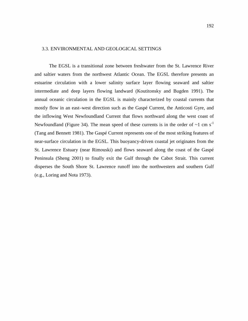
192
3.3. ENVIRONMENTAL AND GEOLOGICAL SETTINGS
The EGSL is a transitional zone between freshwater from the St. Lawrence River
and saltier waters from the northwest Atlantic Ocean. The EGSL therefore presents an
estuarine circulation with a lower salinity surface layer flowing seaward and saltier
intermediate and deep layers flowing landward (Koutitonsky and Bugden 1991). The
annual oceanic circulation in the EGSL is mainly characterized by coastal currents that
mostly flow in an east–west direction such as the Gaspé Current, the Anticosti Gyre, and
the inflowing West Newfoundland Current that flows northward along the west coast of
Newfoundland (Figure 34). The mean speed of these currents is in the order of ~1 cm s-1
(Tang and Bennett 1981). The Gaspé Current represents one of the most striking features of
near-surface circulation in the EGSL. This buoyancy-driven coastal jet originates from the
St. Lawrence Estuary (near Rimouski) and flows seaward along the coast of the Gaspé
Peninsula (Sheng 2001) to finally exit the Gulf through the Cabot Strait. This current
disperses the South Shore St. Lawrence runoff into the northwestern and southern Gulf
(e.g., Loring and Nota 1973).

193
Figure 35. Simplified map of the continental geological provinces around the Estuary and Gulf of St. Lawrence (modified from Farmer et al. 2003). The locations of the sediment cores COR0602-36PC (estuary; blue star) and COR0503-CL04-36PC (gulf; red star) studied herein are indicated. The location of cores MD95-2033 (orange circle; Stevenson et al. 2008) and 91-045-094 (green circle; Fagel et al. 1999) are also shown. The εNd signatures of the Labrador Current Water (εNd = -15; Lacan and Jeandel 2004; Lacan et al. 2012) and North Atlantic Current Water (εNd = -11; Spivack and Wasserburg 1988; Lacan et al. 2012) are reported. A simplified model of sea surface circulation is schematized according to Galbraith et al. (2016).
Over time, Quaternary glacial erosion and deposition formed three submarine u-
shaped channels in the EGSL—the Anticosti and Esquiman Channels in the Northeast Gulf
and the Laurentian Channel—that represent the main characteristic feature of the EGSL
(King and MacLean 1970; Loring and Nota 1973; Piper et al. 1990; St-Onge et al. 2011).
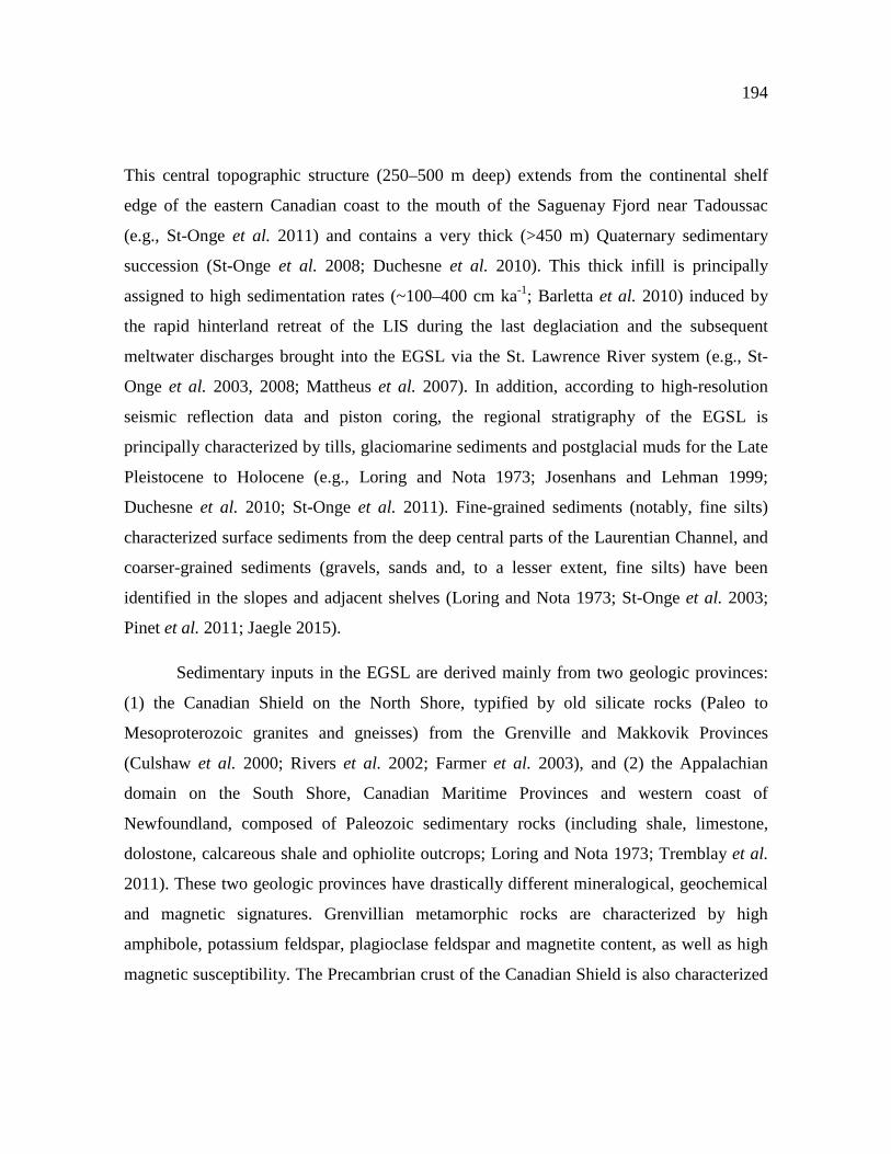
194
This central topographic structure (250–500 m deep) extends from the continental shelf
edge of the eastern Canadian coast to the mouth of the Saguenay Fjord near Tadoussac
(e.g., St-Onge et al. 2011) and contains a very thick (>450 m) Quaternary sedimentary
succession (St-Onge et al. 2008; Duchesne et al. 2010). This thick infill is principally
assigned to high sedimentation rates (~100–400 cm ka-1; Barletta et al. 2010) induced by
the rapid hinterland retreat of the LIS during the last deglaciation and the subsequent
meltwater discharges brought into the EGSL via the St. Lawrence River system (e.g., St-
Onge et al. 2003, 2008; Mattheus et al. 2007). In addition, according to high-resolution
seismic reflection data and piston coring, the regional stratigraphy of the EGSL is
principally characterized by tills, glaciomarine sediments and postglacial muds for the Late
Pleistocene to Holocene (e.g., Loring and Nota 1973; Josenhans and Lehman 1999;
Duchesne et al. 2010; St-Onge et al. 2011). Fine-grained sediments (notably, fine silts)
characterized surface sediments from the deep central parts of the Laurentian Channel, and
coarser-grained sediments (gravels, sands and, to a lesser extent, fine silts) have been
identified in the slopes and adjacent shelves (Loring and Nota 1973; St-Onge et al. 2003;
Pinet et al. 2011; Jaegle 2015).
Sedimentary inputs in the EGSL are derived mainly from two geologic provinces:
(1) the Canadian Shield on the North Shore, typified by old silicate rocks (Paleo to
Mesoproterozoic granites and gneisses) from the Grenville and Makkovik Provinces
(Culshaw et al. 2000; Rivers et al. 2002; Farmer et al. 2003), and (2) the Appalachian
domain on the South Shore, Canadian Maritime Provinces and western coast of
Newfoundland, composed of Paleozoic sedimentary rocks (including shale, limestone,
dolostone, calcareous shale and ophiolite outcrops; Loring and Nota 1973; Tremblay et al.
2011). These two geologic provinces have drastically different mineralogical, geochemical
and magnetic signatures. Grenvillian metamorphic rocks are characterized by high
amphibole, potassium feldspar, plagioclase feldspar and magnetite content, as well as high
magnetic susceptibility. The Precambrian crust of the Canadian Shield is also characterized

195
by very low εNd signatures (εNd = -32; Stevenson et al. 2008; Innocent et al. 1997).
Sediments originating from the Grenville Province have a low Nd isotopic ratio (εNd = -22;
Farmer et al. 2003; Pratte et al. 2017; Figure 34) and a large distribution of the Sr isotopic
composition, with 87Sr/86Sr ratios ranging from 0.7094 to 0.7746 (Millot 2002; Charlier et
al. 2015), while Paleozoic sedimentary rocks from the Appalachian domain are
characterized by high quartz, phyllosilicates (mainly biotite and muscovite) and hematite
content, as well as low magnetic susceptibility (Loring and Nota 1973; Whalen et al. 1996;
Jaegle 2015). Sediments from the Appalachian domain also record a Pan-African Nd
isotope signature (εNd ≈ -11; Stevenson et al. 2008) (Figure 34) and 87Sr/86Sr values
varying from 0.7103 and 0.7633 (van Breemen and Dallmeyer, 1984; Samson et al. 1995;
Vinciguerra et al. 2016). One of the broad conclusions of these studies is that Nd isotopic
composition and elemental geochemical variations recorded in the Laurentian Channel
sediment cores can be associated with changes in the relative contributions of various
sediment sources.
3.4. MATERIAL AND METHODS
3.4.1. SAMPLES
Two sediment cores from the lower St. Lawrence Estuary (COR0602-36PC) and
Gulf of St. Lawrence (COR0503-CL04-36) were collected on board the research vessel
(R/V) Coriolis II during two different cruises in June 2005 (COR0503) and 2006
(COR0602). These sediment cores were recovered along the axis of the Laurentian
Channel, from the head and the mouth respectively, using a piston corer, allowing the
sampling of cores up to 7.90 m. All coring sites were targeted using high-resolution seismic

196
profiles that indicated high sediment accumulation not influenced by mass wasting events
(Barletta et al. 2010).
3.4.2. CHRONOSTRATIGRAPHIC FRAMEWORK
The chronostratigraphic framework of all sediment cores used in this study was
published previously and derived from 17 AMS-14C ages obtained on marine mollusc shell
fragments (Barletta et al. 2010). Further support of the age model of core COR0602-36PC
comes from comparison of magnetic susceptibility profiles of the lower part (562 cm) of
the core with nearby core MD99-2221 (St-Onge et al. 2003). Characteristic peaks in both
magnetic susceptibility curves have been identified in order to transfer the age model of
core MD99-2221 to core COR0602-36PC below 562 cm where no radiocarbon ages are
available (Annex 1). The R software package BACON (Blaauw and Christen 2011) was
used to produce the ‘best fit’ linearly interpolated age models. BACON uses a Bayesian
approach to estimate the best fit or weighted mean age for each depth with a 95%
confidence interval. Overall, the chronostratigraphic framework of all these sediment cores
suggests high sedimentation rates in the last 10 cal. ka BP (300 to 40 cm ka-1) (Figure 35).
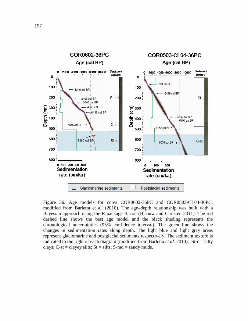
197
Figure 36. Age models for cores COR0602-36PC and COR0503-CL04-36PC, modified from Barletta et al. (2010). The age–depth relationship was built with a Bayesian approach using the R-package Bacon (Blaauw and Christen 2011). The red dashed line shows the best age model and the black shading represents the chronological uncertainties (95% confidence interval). The green line shows the changes in sedimentation rates along depth. The light blue and light gray areas represent glaciomarine and postglacial sediments respectively. The sediment texture is indicated to the right of each diagram (modified from Barletta et al. 2010). St-c = silty clays; C-st = clayey silts; St = silts; S-md = sandy muds.

198
3.4.3. ANALYTICAL PROCEDURES
3.4.3.1. BULK SEDIMENT LEACHING
Seawater Sr and Nd isotopic signatures from authigenic Fe-Mn coatings of the bulk
sediment were extracted applying the leaching protocol of Chen et al. (2012). Briefly, 1g of
dried and powdered sediments were rinsed three times with Milli-Q water. Next, Sr and Nd
contained in the sediment oxyhydroxide fraction were leached for about 1h in a single step
using a dilute reducing and complexing solution consisting of 0.005M hydroxylamine
hydrochloride (HH), 1.5% acetic acid, and 0.03M Na-EDTA, buffered to pH = 4 with
suprapur NaOH. A buffered acetic acid leach step was omitted since biogenic carbonates
are negligible in all sediment samples (Casse et al. 2017). During treatment, the sediment
samples were gently shaken to enhance the reaction. After centrifugation, the leach solution
was decanted, evaporated and re-dissolved in 2 mL of 2.5 M HCl. This last solution was
divided into two aliquots of 1 mL, one for the REE concentration analyses and the other
one for the Nd and Sr chromatographic extraction. The aliquot for REE concentration
analysis was evaporated almost to dryness, the residue is re-dissolved in 1 mL of
concentrated HNO3 and subsequently diluted with Milli-Q water to a total volume of 5 mL.
3.4.3.2. SR AND ND SEPARATION: COLUMN CHEMISTRY
Sr and Nd were separated from other elements applying a single-step ion
chromatographic separation (Li et al. 2014). Briefly, the leaching solutions obtained from
previous steps were centrifuged at 5000 rpm for 8 min. Then, 1 mL of the supernatant
solution was passed through two-layered mixed resin column (70 mm length, 6 mm
diameter) with the upper layer containing 1.5 mL of Biorad® AG50W-X12 (200–400
199
mesh) resin and the bottom layer containing 0.45 mL of Eichrom® LN Spec resin (100–
150 μm). Before sample loading for separation of Sr–Nd from the sample matrix, the mixed
resin column was pre-washed with 18 mL of 6 M HCl, 8 mL of 3 M HF, and 4 mL of H2O
in turn. After sample loading and rinsing four times with 0.5 mL of 2.5 M HCl, the column
was washed with 13.5 mL of 2.5 M HCl. Most matrix elements (K, Ca, Na, Mg, Al, Fe,
Mn, Ti) and Rb were removed during this step. Then, the Sr fraction was stripped with 5.5
mL of 2.5 M HCl. Part of the HREEs (Dy, Ho, Er, Tm, Yb, Lu) and Ba were then washed
out with 3 mL of 2.5 M HCl. Next, Nd was then isolated from other REEs with 8 mL of 6
M HCl. Sr and Nd fractions were dried on a hotplate at 120°C to dryness and prepared for
isotope measurements.
3.4.3.3. REE CONCENTRATIONS AND SR-ND ANALYSIS
REEs concentrations were determined using an inductively coupled plasma-
quadrupole mass spectrometer (ICP-QMS Agilent 7500c) at ISMER. Due to isobaric
interferences, Eu concentrations were corrected for the residual presence of Ba-generating
oxides at masses 151 and 153, and Gd concentrations, taking into account the influence of
Pr oxides (about 2%). Procedural blanks always accounted for less than 1% of the lowest
concentration measured in the samples. The analytical accuracy and precision were found
to be better than 5% for all REE, as checked by international standards and analysis of
replicate samples. REE were normalized to Post Archaean Australian Shale (PAAS,
Pourmand et al. 2012) in order to evaluate the REE patterns as given in Martin et al. (2010)
and Du et al. (2016). Fractionation between light REE (LREE: La–Nd), medium REE
(MREE: Sm–Dy) and heavy REE (HREE: Tm–Lu) was investigated using the following
indices: LREE/HREE ratio determined by (La+Ce+Pr+Nd)/ (Tm+Yb+Lu), and MREE*
ratio corresponding to (2[Gd+Tb+Dy]/[HREE+LREE]). Also, the association of REEs to

200
preferential minerals can be evaluated by the ratio Eu/Eu* defined by (2*Eu)/(Sm+Ga), and
the potential contamination of the detrital phase during the extraction processes by the
Nd/Al ratio (Gutjahr et al. 2007).
Sr isotopic ratios (88Sr/86Sr) were measured in dynamic mode on a Thermo
Scientific Triton Plus™ multicollector thermal ionization mass spectrometer (TIMS) at
GEOTOP (Montreal, Canada). Sr samples were loaded and analyzed on a single zone-
refined Re filament. The mass biases were corrected to a 86Sr/88Sr ratio of 0.1194, assuming
exponential fractionation behaviour. Repeated analyses of the NIST-987 standard yielded
values of 0.71026 (± 0.00001, 2σ reproducibility). This mean value compares well to its
certified value of 0.710248 ± 0.00001 (Weis et al. 2006). The total procedural blanks for
Sr was less than 0.5 ng which is considered negligible compared to the sample yields (>100
ng).
Neodymium isotopic ratios (143Nd/144Nd) were analyzed on a Nu Plasma II
instrument, a Multi-Collector Inductively Coupled Plasma Mass Spectrometer (MC-ICP-
MS) also at GEOTOP. The mass-bias correction was made by monitoring 146Nd/144Nd
(taken to be equal to 0.7219) and applying an exponential-beta factor correction to the other
ratios. Long-term precision of this instrument is given by analyses of JNdi-1 standard
(143Nd/144Nd = 0.512114 +/- 0.000010; n=13). The results were normalized to the accepted 143Nd/144Nd of 0.512115 for the JNdi-1 standard (Tanaka et al. 2000). 143Nd/144Nd isotopic
ratios are expressed in ɛ units (εNd). External reproducibility (2σ) of repeated JNdi-1
standard measurements was between 0.3 and 0.6 εNd units. The blank had an internal 144Nd
signal of 0.2V compared to 3V for the other samples, which represent only 7% of the global
samples intensity. Overall, the total procedural blanks were negligible compared to Nd
extracted from leachates sediments.
All analytical data presented are available electronically in the PANGAEA database
(https://www.pangaea.de/).

201
3.5. RESULTS
3.5.1. SEDIMENT CHARACTERISTICS AND CHRONOSTRATIGRAPHIC FRAMEWORK
In this study, all the sediment cores present two distinct sedimentary units.
According to Barletta et al. (2010), the upper unit is composed of dark gray, bioturbated
silty clays and sandy mud, whereas the lower unit is composed of lighter gray, relatively
homogeneous, slightly bioturbated clayey silts and silty clays (Figure 35). The mean
sedimentation rates of core COR0602-36PC revealed an abrupt change around 8 cal. ka BP,
with variations from ~300 to ~40 cm ka-1. Conversely, the core located at the most seaward
location (COR0503-CL04-36PC) did not show such drastic change in the mean
sedimentation rates (~75 cm ka-1) throughout the Holocene.
3.5.2. RARE EARTH ELEMENT DISTRIBUTION
REE concentrations are presented in Annex 5. In general, REE concentrations have
decreased in the estuary (COR0602-36PC) during the Holocene and conversely increased
in the gulf (COR0503-CL04-36PC) in the last 8 cal. ka BP. The PAAS-normalized REE of
bulk sediment leachates from the gulf reveals an MREE bulge-type pattern, with an
enrichment of MREE compared to HREE and LREE and a significant enrichment in
europium (Figure 36). This MREE bulge enrichment is clearly defined in the sediment
sample from the gulf, whereas the sediments from the estuary present a noticeable
enrichment in both MREE and LREE. The sediment core from the estuary (COR0602-
36PC) does not present any significant variations in the MREE* ratio during the Holocene
(~1.67−1.70; Figure 36). The core from the gulf presents a relative enrichment in the

202
MREE* ratio during the Holocene with a mean value of 1.79 during the deglaciation, which
increases slightly to 1.94 after 8 cal. ka BP (Figure 37B). The HREE/LREE ratio ranges
between 0.41 and 0.50 for the sediment from the gulf, with a mean value of 0.47. This ratio
is substantially lower for the sediment from the estuary, with values ranging from 0.35 and
0.46 and a mean value of 0.40. The anomaly in europium, defined by Eu/Eu*, is relatively
more pronounced in the sediment from the estuary compared to sediment from the gulf
(Figure 36). In the estuary, the europium anomaly is more pronounced after 8 ka cal BP,
with a mean value of 0.86 compared to 0.95 during the deglaciation. In the gulf, the Eu/Eu*
ratio does not present a discernable difference during the Holocene, with a mean value of
0.99 before 8 cal. ka BP compared to 1.02 after the deglaciation. The geochemical ratio
Log(Al/Nd) is exposed to assess the leaching extraction’s ability to obtain an authigenic
signal (Figure 37A). The Log(Al/Nd) ranges from 1.82 to 1.50 with a mean value of 1.64
for the sediment from the gulf (COR0503-CL04-36PC). Similarly, this ratio varies between
1.72 and 1.47 with a mean value of 1.61 for the sediment from the estuary (COR0602-
36PC).

203
Figure 37. REE patterns normalized to PAAS (Pourmand et al., 2012) for the bulk leachate sediment samples of (A) core COR0503-CL04-36PC (gulf) and (B) core COR0602-36PC (estuary).
3.5.3. STRONTIUM ISOTOPE SIGNATURES
87Sr/86Sr values obtained from bulk sediment leachates in the sedimentary core
COR0602-36PC range from 0.709634 ± 0.00002 to 0.710642 ± 0.00002, with a mean value
of 0.709122 ± 0.00002 (Annexe 6; Figure 37A). The ratio 87Sr/86Sr obtained in the
sedimentary core COR0503-CL04-36PC varies between 0.709072 ± 0.00002 and 0.709158
± 0.00004 with a mean value of 0.709118 ± 0.00003. These values are characteristic of the
present-day authigenic signal (0.709211 ± 0.00037; Elderfields 1986). However, some 87Sr/86Sr values for core COR0602-36PC show slightly more radiogenic Sr isotopic values
than modern seawater.

204
3.5.4. NEODYMIUM ISOTOPE SIGNATURES
For both core COR0602-36PC and core COR0503-CL04-36PC, the εNd values
obtained from bulk sediment leachates represent the minimum values in the lowermost part
of the cores (8–10 cal. ka BP) and maximum values in the uppermost parts (0–8 cal. ka BP)
(Annex 6; Figure 38). εNd obtained from core COR0602-36PC is more unradiogenic than
that obtained from core COR0503-CL04-36PC. Core COR0602-36PC presents εNd values
ranging from -17.3 ± 0.1 to -26.6 ± 0.3 with a mean value of -20.9 ± 0.2, whereas εNd
obtained from core COR0503-CL04-36PC varies between -17.3 ± 0.1 and -22.5 ± 0.2 with
a mean value of -19.1 ± 0.2. Both sedimentary cores present a similar range of maximum
εNd values, which are almost constant after 8 cal. ka BP with εNd mean values of -18.9 and
-17.8 for cores COR0602-36PC and COR0503-CL04-36PC respectively. However, before
8 cal. ka BP, there is a large gap between the unradiogenic εNd values obtained from the
two sedimentary cores. Before 8 cal. ka. BP, core COR0602-36PC records most
unradiogenic εNd values (average -24.3 ± 0.1) compared to core COR0503-CL04-36PC
(average -21.4 ± 0.2).
205
3.6. DISCUSSION
3.6.1. SIGNIFICANCE OF THE ƐND SIGNATURES AND GEOCHEMICAL COMPOSITION OF BULK SEDIMENT LEACHATES
Considering the high detrital contribution in estuarine and coastal marine
environments, the authigenic Nd isotope composition of the sediment cores may differ from
that of the true authigenic signal (e.g., Du et al. 2016). Consequently, before discussing Nd
isotopic signatures of bulk sediment leachates from the EGSL, an evaluation of the
reliability of this extraction process is essential. We compared the Log(Al/Nd) with the 87Sr/86Sr isotopic signal to evaluate the leaching extraction’s potential to provide an
authigenic signal (e.g., Gutjahr et al. 2007; Du et al. 2016; Figure 37A). Sr in seawater has
a residence time in the order of 2.5 Myr (Hodell et al. 1990), which is long compared to the
oceans’ mixing time of 500–1000 years (Tachikawa et al. 2003). One impact is globally
uniform seawater and a marine carbonate 87Sr/86Sr ratio (87Sr/86Sr ∼0.70918; Palmer and
Elderfield 1985; Veizer 1989; Henderson et al. 1994) over periods of ~50 ka, even in
relatively enclosed ocean basins (Winter et al. 1997). Likewise, an additional independent
proxy for estimating the authigenic feature of the extracted phase from marine sediments is
aluminum (Al) content (Gutjahr et al. 2007). Because of the preferential incorporation of
trace metals over Al, the ferromanganese oxy-hydroxide coating usually presents a low
Al/Nd ratio (on the order of 101 to 102) compared to detrital sediments (103 and 104;
Gutjahr et al. 2007; Du et al. 2016). The Al/Nd vs. 87Sr/86Sr ratios of leachate sediments
from the EGSL sediment cores are plotted in Figure 37A. The Al/Nd ratios in both
sediment cores present low values (<100), suggesting that the authigenic signal is obtained
during extraction. In addition, 87Sr/86Sr ratios for the gulf sediments are close to the global
seawater values (~0.70911 ± 0.00003), whereas samples from core COR0602-36PC record
slightly more radiogenic Sr isotopic values than the modern seawater value (~0.71012 ±

206
0.00002; Figure 37A). Note that in the EGSL, biogenic sources of carbonates are negligible
(less than 1%; Jaegle 2015; Casse et al. 2017) and detrital sediments typically have highly
elevated 87Sr/86Sr values (0.71475 to 0.73062; Casse et al. under review). One possible
explanation for this offset in 87Sr/86Sr ratios is that Fe–Mn leachates from the estuary
sediments are slightly contaminated by detrital material during the leaching procedure.
Because of their high Sr content, plagioclase, carbonate and to a lesser extent, clay minerals
(such as muscovite) play a major role in the 87Sr/86Sr signal for detrital sediments (Garçon
et al. 2014). Dissolution of even a small quantity of plagioclase-rich sediments would
therefore release a significant amount of Sr into the leachates and produce offset compared
to modern seawater values. Sediments from the estuary (gulf) are composed of ~39%
(~19%) plagioclase and ~26% (~42%) clay minerals (Casse et al. 2017). We therefore
suggest that the Sr isotopic differences between the estuary and gulf could be explained by
higher relative contributions of plagioclase from the North Shore in the estuary relative to
the gulf.

207
Figure 38. (A) Log(Al/Nd) ratio compared to the 87Sr/86Sr isotopic composition and (B) comparison of HREE/LREE vs. MREE* cross-plots (Du et al. 2016) obtained from the bulk sediment leachate of the sediment cores COR0602-36PC (estuary) and COR0503-CL04-36PC (gulf) and compared with detrital surface sediments, leachate surface sediment and seawater samples from Casse et al. under review.
In order to further evaluate the efficiency of our procedure to extract the authigenic
phase, we compared the HREE/LREE ratio to the MREE* (Figure 37B). Because of the
systematic decrease in ionic radius with increasing atomic numbers, the REE shows
significant fractionation in the marine environment. Based on this fact, evaluation of the
REE distribution pattern can provide information on the main geochemical processes in the
ocean. The HREE/LREE—MREE* cross-plots (Figure 37B) reveal that all our bulk
sediment leachates plot on the Fe-Mn leachate array, notably with a mean MREE* of 1.91
and 1.69 for cores COR0503-CL04-36 and COR0602-36PC respectively, corresponding to
the most MREE-enriched leachate sediments (Gutjahr et al. 2010). These results are
208
consistent with results obtained for bulk sediment leachates from EGSL surface samples
(Casse et al. under review). All these observations concurred to indicate that authigenic Fe–
Mn oxyhydroxide coatings control the Nd signal in our bulk sediment leachates.
Furthermore, early diagenetic remobilization in marine sediments has been shown to
fractionate the REEs significantly from one another (Chen et al. 2015). However, because
we did not observe significant differences in the REE distribution profile between surface
sediment and the remainder of the Holocene, we suggest that the early diagenesis processes
had a negligible effect on REE distribution. Likewise, as suggested in Casse et al.. (under
review), other sedimentary processes such as riverine input of oxide sediment coatings or
remineralization of organic matter (e.g., Bayon et al. 2004; Freslon et al. 2014) have a
negligible influence on the authigenic Nd isotopic signal in the EGSL.
The mean authigenic εNd values obtained from both core COR0503-CL04-36PC
(average εNd ~ -19.1 ± 0.2) and core COR0602-36PC (average εNd ~ -20.9 ± 0.2) are
very unradiogenic compared to the actual εNd values of LCW (εNd ~ -15; Lacan and
Jeandel 2004; Lacan et al. 2012) and NACW (εNd ~ -11; Piepgras and Wasserburg 1987;
Lacan et al. 2012). According to Frank (2002), one of the most important sources for the
dissolved Nd budget of water masses is riverine input, although most of the dissolved Nd
river load is precipitated to form oxyhydroxides in estuarine sediments (Goldstein and
Jacobsen 1988; Elderfield et al. 1990; Ingri et al. 2000). The authigenic εNd signal in the
EGSL therefore likely represents mainly the unradiogenic εNd detrital signatures resulting
from the erosion of the Grenvillian metamorphic rocks of the Canadian Shield (εNd ~ -22;
Farmer et al. 2003; Pratte et al. 2017) and, to a lesser extent, the early Paleozoic
sedimentary rocks of the Appalachian domain on the South Shore, Canadian Maritime
Provinces and western coast of Newfoundland (εNd ~ -11; Stevenson et al. 2008).
However, we cannot rule out the possibility that the LCW/NACW εNd signatures are
present in our authigenic εNd signal. Given the high river discharges and detrital influence

209
in the EGSL, we suggest that the LCW/NACW signal recorded in the EGSL bottom
sediments is masked by the εNd signatures of continental river inputs (e.g., Casse et al.
under review). Overall, these results confirm that Nd isotopes and REE distributions
obtained from bulk sediment leachates may be used to further understand changes in
continental weathering regimes in the EGSL over time.
To highlight the evolution of the sedimentary dynamics in the EGSL over the last
10,000 years, the changes observed in our ɛNd signal and REE concentrations will be
discussed below, together with variations in grain size end-members [Log(EM2/EM1)],
bulk mineralogy [phyllosilicates/(plagioclase+ K-feldspar)] and elemental geochemical
[Log(Zn/Sr)] data obtained from the same sediment cores (Casse et al. 2017). Based on an
end-member modeling analysis (EMMA) of the grain size data for the cores COR0503-
CL04-36PC and COR0602-36PC, Casse et al. (2017), we used the log-ratio between the
end-member EM2 (associated with fine to medium silts, 6-18 µm) and the end-member
EM1 (corresponding to the clay, <2 µm) to elucidate down-core grain size variations (silts
vs. clay) within the Laurentian Channel detrital sediments and to investigate sediment
transfer and transport conditions during the glaciomarine and postglacial sedimentation.
Concerning the mineralogical variations, the phyllosilicate ratio (plagioclase+ K-feldspar)
allowed us to discriminate between sediments from the South Shore (Paleozoic sedimentary
rocks from the Appalachian domain) and sediments from the North Shore (Grenvillian
metamorphic rocks). In fact, as suggested in Loring and Nota (1973) and Jaegle (2015),
plagioclase and K-feldspars were more abundant along the North Shore, whereas
phyllosilicates were more common along the South Shore and in the Canadian Maritime
Provinces (on the southwest gulf). In addition, the fact that Log(Zn/Sr) ratios reflect the
sediment source is based on preferential Zn concentration in phyllosilicate minerals,
whereas Sr is associated with plagioclase−K-feldspar minerals (Casse et al. 2017).

210
Figure 39. Relationship between ɛNd (this study) and (A) Log(EM2/EM1), (B) Phy/(Plg+Kfs), (C) Log(Zn/Sr) ratios for the sediment cores COR0602-36PC (estuary) and COR0503-CL04-36PC (gulf) obtained by Casse et al. (2017). The sediment samples are differentiated according to their age.
3.6.2. DEGLACIAL−HOLOCENE SEDIMENT DYNAMICS IN THE ESTUARY AND GULF OF ST. LAWRENCE
During the last deglaciation, the earth’s orbital configuration induced a strong
summer insolation maximum and winter insolation minimum in the northern hemisphere
(Berger and Loutre 1991). This strong boreal summer insolation induced the rapid retreat
and ultimate disappearance of the LIS (e.g., Berger and Loutre 1991, Carlson et al. 2008,
2009; Montero-Serrano et al. 2009, 2011). During this early stage, the rapid hinterland
retreat of the LIS triggered major changes in the EGSL system, engendering alterations not
only in proglacial drainage, but also in relative sea level due to glacio-isostatic rebound
(Dionne 1977; Clark et al. 1978; Dyke and Prest 1987; Shaw et al. 2002, 2006; Rémillard

211
et al. 2016). We will first discuss the potential influence of meltwater discharges from the
LIS on the sedimentary dynamic in the EGSL. We will then document the sedimentary
regime during the Holocene (8.5 cal. ka BP to present) related to changes in postglacial
relative sea level variations.
3.6.2.1. INFLUENCE OF MELTWATER DISCHARGES ON THE SEDIMENTARY DYNAMIC (10–8 KA)
Between 10 and 8 ka cal. BP, the sedimentary dynamic in the EGSL was mainly
controlled by the meltwater discharge from the rapid retreat of the southeastern margin of
the LIS on the Canadian Shield, explaining the very high sedimentation rates (~300 cm ka-
1) observed in the thick, fine-grained sedimentary successions (e.g., Syvitski and Praeg
1989; St-Onge et al. 2003, 2008; Casse et al. 2017) (Figure 35). This fact is consistent with
the conceptual model for the deglaciation of Atlantic Canada proposed by Shaw et al.
(2006). Around 13 cal. ka BP, the ice sheets were largely terrestrial and huge areas of sea
were ice-free, as for instance the Strait of Belle Isle, separating Labrador and
Newfoundland, and Anticosti and Magdalen Islands (e.g., Rémillard et al. 2016). At 9 cal.
ka BP, only the Quebec and Labrador regions were still covered by the LIS, and extensive
emerged areas could be found on the Grand Banks and the Scotian Shelf, as well as large
parts of the southern Gulf of St. Lawrence (Shaw et al. 2006). All these arguments point to
evidence of the LIS on the North Shore in the early Holocene (Dyke and Prest 1987;
Syvitski and Praeg 1989; Shaw et al. 2006), which could acoount for the huge amount of
meltwater discharge into the EGSL. The very unradiogenic εNd mean values recorded by
cores COR0602-36PC (εNd = -24.3 ± 0.1) and COR0503-CL04-36PC (εNd = -21.4 ± 0.2)
before 8 cal. ka BP support the idea that the North Shore represents the primarily source of
sediments delivered to the EGSL at that time (Figure 38). The Canadian Shield is
212
characterized by a very low εNd signature (εNd = -32; Innocent et al. 1997; Stevenson et
al. 2008). More specifically, sediments originating from the Grenville Province have a low
Nd isotopic ratio (εNd = -22; Farmer et al. 2003; Pratte et al. 2017).
The εNd vs. Log(EM2/EM1) cross-plots reveal a common sedimentary source
(Canadian Shield) for the both core COR0602-36PC and core COR0503-CL04-36PC
before 8 ka cal. BP (Figure 38A). In the early Holocene, glaciomarine sediments were
mainly composed of clay (up to 80%; EM1) in both sediment cores, whereas fine to
medium silts (EM2) dominated during the last 8 ka cal. BP. These results support the idea
that the rapid hinterland retreat of the southeastern margin of the LIS on the Canadian
Shield during deglaciation (10–8 cal. ka BP) induced a sediment-laden meltwater plume
coming from the North Shore, leading to the accumulation of fine-grained sediments in the
ice-distal zones of the EGSL (Casse et al. 2017). The weak hydrodynamic conditions
prevailing in these ice-distal glaciomarine environments caused a less turbulent
depositional setting and therefore the preferential accumulation of fine-grained sediments.
The εNd coupled with phyllosilicates/(plagioclase+K-feldspar) and Log(Zn/Sr)
ratios suggest a mixed provenance of detrital particles between 10 and 8 cal. ka BP in both
cores. The fine-grained glaciomarine sediments in the estuary mainly originated from the
North Shore with a noticeable contribution from the South Shore, as evidenced by an
increase in phyllosilicates relative to feldspars, a higher Log(Zn/Sr) ratio and very
unradiogenic ɛNd values (Figure 38B, C). Concurrently in the gulf, the low
phyllosilicates/(plagioclase+K-feldspar) and Log(Zn/Sr) ratios as well as unradiogenic ɛNd
values observed during the early Holocene suggest that the fine-grained glaciomarine
sediments mainly originated from the North Shore with a minor influence from the
Canadian Maritime Provinces. The increase in feldspars relative to phyllosilicates most
likely suggests that the fine-grained glaciomarine sediments in the gulf contain higher
proportions of rock flour derived from glacial erosion of the crystalline rocks on the
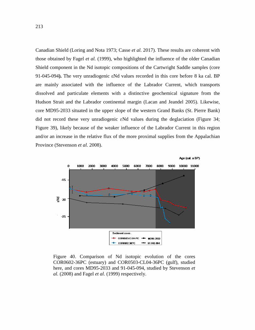
213
Canadian Shield (Loring and Nota 1973; Casse et al. 2017). These results are coherent with
those obtained by Fagel et al. (1999), who highlighted the influence of the older Canadian
Shield component in the Nd isotopic compositions of the Cartwright Saddle samples (core
91-045-094). The very unradiogenic εNd values recorded in this core before 8 ka cal. BP
are mainly associated with the influence of the Labrador Current, which transports
dissolved and particulate elements with a distinctive geochemical signature from the
Hudson Strait and the Labrador continental margin (Lacan and Jeandel 2005). Likewise,
core MD95-2033 situated in the upper slope of the western Grand Banks (St. Pierre Bank)
did not record these very unradiogenic ɛNd values during the deglaciation (Figure 34;
Figure 39), likely because of the weaker influence of the Labrador Current in this region
and/or an increase in the relative flux of the more proximal supplies from the Appalachian
Province (Stevenson et al. 2008).
Figure 40. Comparison of Nd isotopic evolution of the cores COR0602-36PC (estuary) and COR0503-CL04-36PC (gulf), studied here, and cores MD95-2033 and 91-045-094, studied by Stevenson et al. (2008) and Fagel et al. (1999) respectively.
214
3.6.2.2. SEDIMENTARY REGIME DURING THE HOLOCENE AND ESTABLISHMENT OF THE CURRENT STABLE OCEANIC CONDITIONS (8 CAL. KA BP TO PRESENT)
The decrease in the sedimentation rates from about 300 to 40 cm ka-1 observed at 8
cal. ka BP (Figure 35) provides evidence for a drastic decrease in erosional processes in the
EGSL as the LIS margin withdrew from its southeastern-most extent and the meltwater
discharges re-routed toward Hudson Bay and Hudson Strait (St-Onge et al. 2003, 2011).
Because of the reducing LIS meltwater discharge through the St. Lawrence Estuary, we
supposed that the variations in Nd isotope, REEs and grain size as well as mineralogical
and geochemical signatures observed after 8 cal. ka BP cannot be linked to changes in the
extent of the LIS. According to Casse et al. (2017), the relative changes in sea level due to
glacio-isostatic rebound have driven a significant control on sedimentation in the EGSL.
Because changes in relative sea level following the deglaciation were not uniform in
eastern Canada (Clark et al. 1978), we compared our detrital proxy data with the relative
sea level curve that is closest geographically to our two sediment cores (Clark et al. 1978;
Shaw et al. 2002): (i) the Sept-Îles curve on the North Shore was compared with core
COR0602-36PC from the estuary (Figure 40A), and (ii) the Port au Port curve on
Newfoundland’s west coast was compared with core COR0503-CL04-36PC (Figure 40A’).
The parallel temporal evolution observed between the RSL curves and our detrital proxies
suggests that the glacio-isostatic relative sea level variations have exerted significant
control on sedimentation in the EGSL during the mid to late Holocene (Figure 40).

215
Figure 41. Multiproxy analysis for core COR0602-36PC and core COR0503-CL05-37PC illustrating the evolution of sedimentary dynamics between 10–8 cal. ka BP and since 8 cal. ka BP. The relative sea level variations, Log(Zn/Sr), Phy/(Plg+Kfs), Eu/Eu*, HREE/LREE and ɛNd are compared for each sediment core during the Holocene. During the early Holocene, the meltwater discharges induced by the rapid retreat of the LIS on the North Shore appear to be the predominant force acting on the sedimentation (LIS position is schematic for the period from 10 to 9 cal. ka BP; Shaw et al. 2002). Beyond 8 cal. ka BP, the sediment dynamic is mainly controlled by variations in the relative sea level.
Between 8 cal. ka BP and the present day, the authigenic Nd isotopic signatures
obtained from sediment cores COR0602-36PC and COR0503-CL04-36PC revealed mean
εNd values of -18.9 ±0.2 (Figure 40F) and -17.8 ±0.3 (Figure 40F') respectively, which
represent a dominance of unradiogenic εNd detrital signatures derived from the erosion of

216
the Grenvillian metamorphic rocks of the Canadian Shield on the North Shore. However,
authigenic εNd values are relatively lower (by ~1.1 ε-units) in the sediment from the
estuary compared to the gulf (Figure 39), likely due to their proximity to the unradiogenic
North Shore. The authigenic Nd signature in the estuary is essentially delivered by the
particulates transported by the riverine inputs from the North Shore, with a minor
proportion of sediment from the Appalachian Province (~ 14%) (Casse et al. under review).
These more radiogenic values correlate with a concomitant dominance of fine to medium
silt particles (EM2) over the last 8 cal. ka BP (Figure 38A). The relative sea level variations
following the deglaciation play a critical role in determining the vertical reach of storm
surges, wave setup and potential storm impacts on the coast (Forbes et al. 2004), which
may play a decisive role in the increased erosion and subsequent transport of coarser
particles. Furthermore, the mineralogical and geochemical signatures of the sediment from
the estuary and the gulf can clearly be distinguished after 8 cal. ka BP (Figure 38B, C). In
the gulf, the radiogenic Nd isotope signatures correlate with high
phyllosilicates/(plagioclase+K-feldspar) and Log(Zn/Sr) ratios, suggesting that detrital
sediments are derived primarily from the Canadian Maritime Provinces and the South
Shore. Based on the modern surface current circulation patterns in the EGSL, we propose
that the Appalachian sediments recorded in core COR0503-CL04-36PC after the
deglaciation were principally delivered by the Gaspé Current (Casse et al. 2017). The south
branch of this current forms the main outflow of the Gulf on the western side of Cabot
Strait (Loring and Nota 1973; Dufour and Ouellet 2007) and may therefore have
transported Appalachian sediments from the South Shore and Canadian Maritime Provinces
to core COR0503-CL04-36PC (Figure 34)
In the lower estuary (COR0602-36PC), the higher εNd (with a mean value of -18.9)
and low phyllosilicates/(plagioclase+K-feldspar) and Log(Zn/Sr) ratios (Figure 38B-C)
indicate a detrital sediment provenance mainly derived from the Canadian Shield Province,
with the Appalachian Province contributing weakly to overall sedimentation. This

217
Canadian Shield signature is related to a negative europium anomaly value in the bulk
leached sediments (Figure 41). This likely implies that: (1) the mineral phase(s) that are
releasing REEs from the host sediments do not possess a Eu anomaly, or that (2) Eu is
retained in residual minerals during leaching. However, detrital sediments derived from the
Canadian Shield in the estuary are enriched in plagioclase (>40%) than phyllosilicates
(<25%; Jaegle 2015; Casse et al. 2017) and show a flat to convex down REE pattern with a
prominent positive Eu anomaly (Casse et al. under review). A positive Eu anomaly is
generally attributed to plagioclase presence in the source of REEs, as europium has the
tendency to be incorporated preferentially into this mineral (Weill and Drake 1973). Eu3+ is
commonly reduced to Eu2+ during intracrustal partial melting and substitutes for Ca2+
within plagioclase feldspar and carbonates (Weill and Drake 1973; Drake 1975), causing
enrichment of Eu in plagioclase-rich continental rocks (anorthosite massifs found on the
North Shore being an extreme case; REF). Therefore, the negative europium anomaly
observed in our leached bulk samples from the lower estuary most likely suggest that Eu is
retained in the residual minerals (notably in plagioclase). Indeed, Yan et al. (1999) showed
that during a sequential leaching experiment of clay-rich glacial till samples from the
southern Saskatchewan (Canada), the majority of the REEs (including Eu) were hosted in
residual minerals, in agreement to our interpretations. Overall, variations in the negative
europium anomaly observed in our sediment cores may be used to indirectly trace
plagioclase-rich sediments derived from the Canadian Shield. Thus, the appearance of a
noticeable negative europium anomaly after the deglaciation in core COR0602-36PC
(average Eu/Eu* = 0.86) most likely supports the idea that the Canadian Shield Province
represents the primary source for detrital sediments in the lower estuary. These
interpretations are consistent with the slightly more radiogenic Sr isotopic values recorded
in the estuary sediments, indicating a high contribution of plagioclase in the global
sedimentation (Figure 37A). Likewise, the europium anomaly was not observed in the
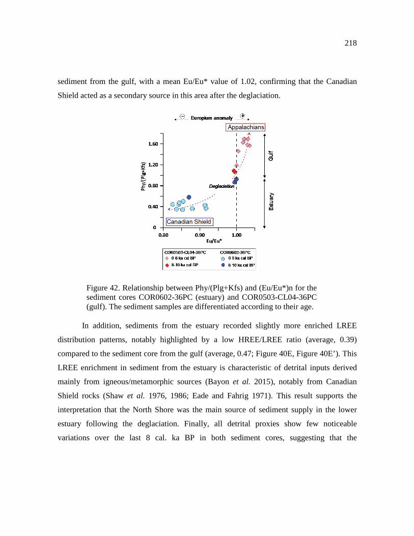
218
sediment from the gulf, with a mean Eu/Eu* value of 1.02, confirming that the Canadian
Shield acted as a secondary source in this area after the deglaciation.
Figure 42. Relationship between Phy/(Plg+Kfs) and (Eu/Eu*)n for the sediment cores COR0602-36PC (estuary) and COR0503-CL04-36PC (gulf). The sediment samples are differentiated according to their age.
In addition, sediments from the estuary recorded slightly more enriched LREE
distribution patterns, notably highlighted by a low HREE/LREE ratio (average, 0.39)
compared to the sediment core from the gulf (average, 0.47; Figure 40E, Figure 40E’). This
LREE enrichment in sediment from the estuary is characteristic of detrital inputs derived
mainly from igneous/metamorphic sources (Bayon et al. 2015), notably from Canadian
Shield rocks (Shaw et al. 1976, 1986; Eade and Fahrig 1971). This result supports the
interpretation that the North Shore was the main source of sediment supply in the lower
estuary following the deglaciation. Finally, all detrital proxies show few noticeable
variations over the last 8 cal. ka BP in both sediment cores, suggesting that the

219
establishment of modern oceanographic conditions in the EGSL likely occurred during the
mid-Holocene.
3.7. SUMMARY AND CONCLUSIONS
Using radiogenic Nd isotopes and REE patterns on bulk sediment leachates from
two sediment cores recovered in the Laurentian Channel, we have examined the origin,
transport and dynamics of detrital sediments in the EGSL since the deglaciation.
Authigenic Nd isotope compositions in the EGSL support the idea that variations in the
radiogenic Nd isotopic signal were not controlled by changes in water mass provenance and
mixing. Instead, this Nd signal represents mainly unradiogenic εNd detrital signatures from
the adjacent continents, notably from the erosion of the Grenvillian metamorphic rocks of
the Canadian Shield and to a lesser extent, from the early Paleozoic sedimentary rocks of
the Appalachian domain. Overall, these data provide additional information related to bulk
mineralogical and elemental geochemical records previously published by Casse et al.
(2017). Their comparison robustly confirms that two sedimentary regimes have operated in
the EGSL over the last 10,000 years:
(1) During the early Holocene (10–8 ka cal BP), unradiogenic εNd values and REE
patterns, associated with high sedimentation rates (~300 cm ka-1), suggest that much of the
sediments were delivered by sediment-laden meltwater discharges from the North Shore,
caused by the rapid hinterland retreat of the southeastern margin of the LIS on the Canadian
Shield (ɛNd = -32 to -22). The early Paleozoic sedimentary rocks of the Appalachian
domain on the South Shore and Canadian Maritime Provinces acted as secondary sources
of local influence.
220
(2) From 8 ka to the present, LIS melting no longer exerted influence on the
sediment dynamics in the EGSL and the relative sea level variations following the
deglaciation appear as the predominant forces acting on sedimentation in the EGSL during
the mid- to late Holocene. In the estuary, a clear europium anomaly combined with LREE
enrichment suggests that the sediments are mainly dominated by sources from the North
Shore. Conversely, a low europium anomaly and high HREE/LREE ratio indicate that the
sediments in the gulf are mainly delivered from the Appalachian Province on the South
Shore and Canadian Maritime Provinces via the south branch of the Gaspé Current.
The absence of any major changes in our detrital records over the last 8 cal. ka BP
confirms that the onset of the modern sedimentation regime in the EGSL occurred during
the mid-Holocene. Finally, authigenic Nd isotope compositions and REE distribution
appear to be useful tools to (1) discriminate between different continental sources
delivering sediment to the EGSL and adjacent continent shelf and (2) to determinate the
possible oceanographic and/or climatic forces acting on sedimentation during the late
Quaternary.
3.8. ACKNOWLEDGEMENTS
This research was funded by the FRQ-NT (établissement de nouveaux chercheurs
universitaires to J-C Montero-Serrano), ISMER excellence scholarships (M. Casse), as well
as by the Natural Sciences and Engineering Research Council of Canada (NSERC) through
Discovery Grants to J-C Montero-Serrano and G. St-Onge. We thank the captain, crew and
scientists of the COR0503 and COR0602 campaigns on board the R/V Coriolis II. We also
thank Mathieu Babin from UQAR-ISMER for his technical support and advice.

221
3.9. REFERENCES
Barletta, F., St-Onge, G., Stoner, J.S., Lajeunesse, P. & Locat, J., 2010. A high-resolution Holocene paleomagnetic secular variation and relative paleointensity stack from eastern Canada. Earth and Planetary Science Letters 298(1), 162–174. doi:10.1016/j.epsl.2010.07.038
Bataille, C.P. & Bowen, G.J., 2012. Mapping 87Sr/86Sr variations in bedrock and water for large scale provenance studies. Chemical Geology 304, 39–52. doi:10.1016/j.chemgeo.2012.01.028
Bayon, G., German, C.R., Burton, K.W., Nesbitt, R.W. & Rogers, N., 2004. Sedimentary Fe–Mn oxyhydroxides as paleoceanographic archives and the role of aeolian flux in regulating oceanic dissolved REE. Earth and Planetary Science Letters 224(3), 477–492. doi:10.1016/j.epsl.2004.05.033
Bayon, G., Henderson, G.M., Etoubleau, J., Caprais, J.-C., Ruffine, L., Marsset, T., Dennielou, B., Cauquil, E., Voisset, M. & Sultan, N., 2015. U-Th isotope constraints on gas hydrate and pockmark dynamics at the Niger delta margin. Marine Geology 370, 87–98. doi:10.1016/j.margeo.2015.10.012
Berger, A. & Loutre, M.F., 1991. Insolation values for the climate of the last 10 million years. Quaternary Science Reviews 10(4), 297–317. doi:10.1016/0277-3791(91)90033-Q
Blaauw, M. & Christen, J. A., 2011. Flexible paleoclimate age-depth models using an autoregressive gamma process. Bayesian Analysis 6(3), 457–474.
Carlson, A. E., LeGrande, A. N., Oppo, D. W., Came, R. E., Schmidt, G. A., Anslow, F. S. & Obbink, E. A., 2008. Rapid early Holocene deglaciation of the Laurentide ice sheet. Nature Geoscience 1(9), 620–624.
Carlson, A.E., Anslow, F.S., Obbink, E.A., LeGrande, A.N., Ullman, D.J. & Licciardi, J.M., 2009. Surface-melt driven Laurentide Ice Sheet retreat during the early Holocene. Geophysical Research Letters 36(24). doi:10.1029/2009GL040948

222
Carlson, A.E., Clark, P.U., Haley, B.A., Klinkhammer, G.P., Simmons, K., Brook, E.J. & Meissner, K.J., 2007. Geochemical proxies of North American freshwater routing during the Younger Dryas cold event. Proceedings of the National Academy of Sciences 104(16), 6556–6561.
Casse, M., Montero-Serrano, J.-C. & St-Onge, G., 2017. Influence of the Laurentide Ice Sheet and relative sea-level changes on sediment dynamics in the Estuary and Gulf of St. Lawrence since the last deglaciation. Boreas 46, 541–561. doi:10.1111/bor.12230
Casse, M., Montero-Serrano, J.-C., St-Onge, G. & Poirier, A. (under review). REE and Nd-Sr isotope compositions of surface sediments from eastern Canada: Extraction of seawater signatures and detrital provenance. Marine Chemistry.
Charlier, B., Namur, O., Bolle, O., Latypov, R. & Duchesne, J.-C., 2015. Fe–Ti–V–P ore deposits associated with Proterozoic massif-type anorthosites and related rocks. Earth-Science Reviews 141, 56–81. doi:10.1016/j.earscirev.2014.11.005
Chen, T.-Y., Frank, M., Haley, B.A., Gutjahr, M. & Spielhagen, R.F., 2012. Variations of North Atlantic inflow to the central Arctic Ocean over the last 14 million years inferred from hafnium and neodymium isotopes. Earth and Planetary Science Letters 353, 82–92. doi:10.1016/j.epsl.2012.08.012
Chen, J., Algeo, T.J., Zhao, L., Chen, Z.-Q., Cao, L., Zhang, L. & Li, Y., 2015. Diagenetic uptake of rare earth elements by bioapatite, with an example from Lower Triassic conodonts of South China. Earth-Science Reviews 149, 181–202. doi:10.1016/j.earscirev.2015.01.013
Clark, J.A., Farrell, W.E. & Peltier, W.R., 1978. Global changes in postglacial sea level: A numerical calculation. Quaternary Research 9(3), 265–287. doi:10.1016/0033-5894(78)90033-9
COHMAP Members, 1988. Climatic changes of the last 18,000 years: observations and model simulations. Science 241, 1043–1052.
Culshaw, N., Brown, T., Reynolds, P.H. & Ketchum, J.W., 2000. Kanairiktok shear zone: the boundary between the Paleoproterozoic Makkovik Province and the Archean Nain Province, Labrador, Canada. Canadian Journal of Earth Sciences 37(9), 1245–1257. doi:10.1139/e00-035

223
Dionne, J.-C., 1977. La mer de Goldthwait au Québec. Géographie physique et Quaternaire 31(1-2), 61. doi:10.7202/1000055ar
Drake, M.J., 1975. The oxidation state of europium as an indicator of oxygen fugacity. Geochimica et Cosmochimica Acta 39(1), 55–64. doi:10.1016/0016-7037(75)90184-2
Du, J., Haley, B.A. & Mix, A.C., 2016. Neodymium isotopes in authigenic phases, bottom waters and detrital sediments in the Gulf of Alaska and their implications for paleo-circulation reconstruction. Geochimica et Cosmochimica Acta 193, 14–35. doi:10.1016/j.gca.2016.08.005
Duchesne, M.J., Pinet, N., Bédard, K., St-Onge, G., Lajeunesse, P., Campbell, D.C. & Bolduc, A., 2010. Role of the bedrock topography in the Quaternary filling of a giant estuarine basin: the Lower St. Lawrence Estuary, Eastern Canada. Basin Research 22(6), 933–951. doi:10.1111/j.1365-2117.2009.00457.x
Dufour, R. & Ouellet, P., 2007: Estuary and Gulf of St. Lawrence Marine Ecosystem Overview and Assessment Report. Canadian Technical Report of Fisheries and Aquatic Sciences, 112 pp.
Dyke, A.S. & Prest, V.K., 1987. Late Wisconsinan and Holocene History of the Laurentide Ice Sheet. Géographie physique et Quaternaire 41(2), 237. doi:10.7202/032681ar
Eade, K. E. & Fahrig, W. F., 1971. Geochemical evolutionary trends of Continental Plates : A preliminary study of the Canadian Shield. Geol. Surv. Canada Bull. 179, 51pp.
Elderfield, H., 1986. Strontium isotope stratigraphy. Palaeogeography, Palaeoclimatology, Palaeoecology 57(1), 71–90. doi:10.1016/0031-0182(86)90007-6
Elderfield, H., Upstill-Goddard, R. & Sholkovitz, E. R., 1990. The rare earth elements in rivers, estuaries, and coastal seas and their significance to the composition of ocean waters. Geochimica et Cosmochimica Acta 54(4), 971–991.

224
Fagel, N., Innocent, C., Stevenson, R.K. & Hillaire-Marcel, C., 1999. Deep circulation changes in the Labrador Sea since the Last Glacial Maximum: New constraints from Sm-Nd data on sediments. Paleoceanography 14(6), 777–788. doi:10.1029/1999PA900041
Fagel, N., Not, C., Gueibe, J., Mattielli, N. & Bazhenova, E., 2014. Late Quaternary evolution of sediment provenances in the Central Arctic Ocean: mineral assemblage, trace element composition and Nd and Pb isotope fingerprints of detrital fraction from the Northern Mendeleev Ridge. Quaternary Science Reviews 92, 140–154. doi:10.1016/j.quascirev.2013.12.011
Farmer, G.L., Barber, D. & Andrews, J., 2003. Provenance of Late Quaternary ice-proximal sediments in the North Atlantic: Nd, Sr and Pb isotopic evidence. Earth and Planetary Science Letters 209(1), 227–243. doi:10.1016/S0012-821X(03)00068-2
Filippova, A., Frank, M., Kienast, M., Rickli, J., Hathorne, E., Yashayaev, I.M. & Pahnke, K., 2017. Water mass circulation and weathering inputs in the Labrador Sea based on coupled Hf–Nd isotope compositions and rare earth element distributions. Geochimica et Cosmochimica Acta 199, 164–184. doi:10.1016/j.gca.2016.11.024
Forbes, D.L., Parkes, G.S., Manson, G.K. & Ketch, L.A., 2004. Storms and shoreline retreat in the southern Gulf of St. Lawrence. Marine Geology 210(1), 169–204. doi:10.1016/j.margeo.2004.05.009
Frank, M., 2002. Radiogenic isotopes: Tracers of past ocean circulation and erosional input. Reviews of Geophysics 40(1). doi:10.1029/2000RG000094
Freslon, N., Bayon, G., Toucanne, S., Bermell, S., Bollinger, C., Chéron, S., Etoubleau, J., Germain, Y., Khripounoff, A., Ponzevera, E. & Rouget, M.-L., 2014. Rare earth elements and neodymium isotopes in sedimentary organic matter. Geochimica et Cosmochimica Acta 140, 177–198. doi:10.1016/j.gca.2014.05.016
Galbraith, P. S., Chasse, J., Caverhill, C., Nicot, P., Gilbert, D., Pettigrew, B., Lefaivre, D., Brickman, D., Devine, L. & Lafleur, C., 2016. Physical Oceanographic Conditions in the Gulf of St. Lawrence in 2015. DFO Canadian Science Advisory Secretariat Research Document 2016/056, 90 pp.

225
Garçon, M., Chauvel, C., France-Lanord, C., Limonta, M. & Garzanti, E., 2014. Which minerals control the Nd–Hf–Sr–Pb isotopic compositions of river sediments? Chemical Geology 364, 42–55
Goldstein S. L., O‟Nions R. K. & Hamilton P. J., 1984. A Sm-Nd isotopic study of atmospheric dusts and particulates from major river systems. Earth and planetary Science Letters 70(2), 221–236.
Goldstein, S. J. & Jacobsen, S. B., 1988. Rare earth elements in river waters. Earth and planetary Science Letters 89(1), 35–47.
Goldstein, S.L. & Hemming, S.R., 2003. Long-lived isotopic tracers in oceanography, paleoceanography, and ice-sheet dynamics. Treatise on geochemistry 6(6), 453–489.
Gutjahr, M., Frank, M., Stirling, C., Klemm, V., Vandeflierdt, T. & Halliday, A., 2007. Reliable extraction of a deepwater trace metal isotope signal from Fe–Mn oxyhydroxide coatings of marine sediments. Chemical Geology 242(3), 351–370. doi:10.1016/j.chemgeo.2007.03.021
Gutjahr, M., Hoogakker, B.A.A., Frank, M. & McCave, I.N., 2010. Changes in North Atlantic Deep Water strength and bottom water masses during Marine Isotope Stage 3 (45–35 ka BP). Quaternary Science Reviews 29(19), 2451–2461. doi:10.1016/j.quascirev.2010.02.024
Haley, B.A., Frank, M., Spielhagen, R.F. & Fietzke, J., 2008. Radiogenic isotope record of Arctic Ocean circulation and weathering inputs of the past 15 million years: ACEX Pb, Sr, Nd ISOTOPE RECORDS. Paleoceanography 23(1).doi:10.1029/2007PA001486
Henderson, G.M., Martel, D.J., O’Nions, R.K. & Shackleton, N.J., 1994. Evolution of seawater 87Sr86Sr over the last 400 ka: the absence of glacial/interglacial cycles. Earth and Planetary Science Letters 128(3-4), 643–651. doi:10.1016/0012-821X(94)90176-7
Hodell, D.A., Mead, G.A. & Mueller, P.A., 1990. Variation in the strontium isotopic composition of seawater (8 Ma to present) : Implications for chemical weathering rates and dissolved fluxes to the oceans. Chemical Geology: Isotope Geoscience section 80(4), 291–307.

226
Hoskin, P.W.O. & Ireland, T.R., 2000. Rare earth element chemistry of zircon and its use as a provenance indicator. Geology 28(7), 627.
Ingri, J., Widerlund, A., Land, M., Gustafsson, Ö., Andersson, P. & Öhlander, B., 2000. Temporal variations in the fractionation of the rare earth elements in a boreal river; the role of colloidal particles. Chemical Geology 166(1-2), 23–45.
Innocent, C., Fagel, N., Stevenson, R.K. & Hillaire-Marcel, C., 1997. Sm Nd signature of modern and late Quaternary sediments from the northwest North Atlantic: Implications for deep current changes since the Last Glacial Maximum. Earth and Planetary Science Letters 146(3-4), 607–625. doi:10.1016/S0012-821X(96)00251-8
Jacobsen, S.B. & Wasserburg, G.J., 1980. Sm-Nd isotopic evolution of chondrites. Earth and Planetary Science Letters 50(1), 139–155. doi:10.1016/0012-821X(80)90125-9
Jaegle, M. 2015: Nature et origine des sédiments de surface de l’estuaire du Saint-Laurent. M.Sc. thesis, Université du Québec à Rimouski, 83 pp.
Jeandel, C., Delattre, H., Grenier, M., Pradoux, C. & Lacan, F., 2013. Rare earth element concentrations and Nd isotopes in the Southeast Pacific Ocean. Geochemistry, Geophysics, Geosystems 14(2), 328–341.
Josenhans, H. & Lehman, S., 1999. Late glacial stratigraphy and history of the Gulf of St. Lawrence, Canada. Canadian Journal of Earth Sciences 36(8), 1327–1345.
Jung, S. J. A., Davies, G. R., Ganssen, G. M. & Kroon, D., 2004. Stepwise Holocene aridification in NE Africa deduced from dust-borne radiogenic isotope records. Earth Planet. Sei. Lett. 221(1-4), 27-37.doi:10.1016/S0012-821X(04)00095-0.
Kimoto, A., Nearing, M.A., Shipitalo, M.J. & Polyakov, V.O., 2006. Multi-year tracking of sediment sources in a small agricultural watershed using rare earth elements. Earth Surface Processes and Landforms 31(14), 1763–1774. doi:10.1002/esp.1355
King, L.H. & MacLean, B., 1970. Origin of the outer part of the Laurentian Channel. Canadian Journal of Earth Sciences 7(6), 1470–1484.

227
Koutitonsky, V. G. & Bugden, G. L., 1991. The physical oceanography of the Gulf of St. Lawrence: a review with emphasis on the synoptic variability of the motion. The Gulf of St. Lawrence: small ocean or big estuary 113, 57-90.
Lacan, F. & Jeandel, C., 2004. Neodymium isotopic composition and rare earth element concentrations in the deep and intermediate Nordic Seas: Constraints on the Iceland Scotland Overflow Water signature. Geochemistry, Geophysics, Geosystems 5(11).
Lacan, F. & Jeandel, C., 2005. Neodymium isotopes as a new tool for quantifying exchange fluxes at the continent–ocean interface. Earth and Planetary Science Letters 232(3), 245–257. doi:10.1016/j.epsl.2005.01.004
Lacan, F., Tachikawa, K. & Jeandel, C., 2012. Neodymium isotopic composition of the oceans: A compilation of seawater data. Chemical Geology 300, 177–184. doi:10.1016/j.chemgeo.2012.01.019
Lambelet, M., van de Flierdt, T., Crocket, K., Rehkämper, M., Kreissig, K., Coles, B., Rijkenberg, M.J.A., Gerringa, L.J.A., de Baar, H.J.W. & Steinfeldt, R., 2016. Neodymium isotopic composition and concentration in the western North Atlantic Ocean: Results from the GEOTRACES GA02 section. Geochimica et Cosmochimica Acta 177, 1–29. doi:10.1016/j.gca.2015.12.019
Levac, E., Lewis, M., Stretch, V., Duchesne, K. & Neulieb, T., 2015. Evidence for meltwater drainage via the St. Lawrence River Valley in marine cores from the Laurentian Channel at the time of the Younger Dryas. Global and Planetary Change 130, 47–65. doi:10.1016/j.gloplacha.2015.04.002
Li, C.-F., Guo, J.-H., Yang, Y.-H., Chu, Z.-Y. & Wang, X.-C., 2014. Single-step separation scheme and high-precision isotopic ratios analysis of Sr–Nd–Hf in silicate materials. Journal of Analytical Atomic Spectrometry 29(8), 1467. doi:10.1039/C3JA50384D
Loring, D. H. & Nota, D. J. G., 1964: Recent depositional conditions in the St. Lawrence River and Gulf — A reconnaissance survey. Marine Geology 2, 198–235.

228
McLennan, S. M., 1989. Rare earth elements in sedimentary rocks: influence of provenance and sedimentary processes. Geochemistry and Minerology of Rare Earth Elements, 169-200.
Martin, E.E., Blair, S.W., Kamenov, G.D., Scher, H.D., Bourbon, E., Basak, C. & Newkirk, D.N., 2010. Extraction of Nd isotopes from bulk deep sea sediments for paleoceanographic studies on Cenozoic time scales. Chemical Geology 269(3), 414–431. doi:10.1016/j.chemgeo.2009.10.016
Mattheus, C.R., Rodriguez, A.B., Greene, D.L., Simms, A.R. & Anderson, J.B., 2007. Control of Upstream Variables on Incised-Valley Dimension. Journal of Sedimentary Research 77(3), 213–224. doi:10.2110/jsr.2007.022
Meyer, I., Davies, G.R. & Stuut, J.-B.W., 2011. Grain size control on Sr-Nd isotope provenance studies and impact on paleoclimate reconstructions: An example from deep-sea sediments offshore NW Africa. Geophysics, Geosystems 12(3).doi:10.1029/2010GC003355
Millot, R., Gaillardet, J., Dupré, B. & Allègre, C.J., 2002. The global control of silicate weathering rates and the coupling with physical erosion: new insights from rivers of the Canadian Shield. Earth and Planetary Science Letters 196(1), 83–98.
Montero-Serrano, J.-C., Frank, N., Colin, C., Wienberg, C. & Eisele, M., 2011. The climate influence on the mid-depth Northeast Atlantic gyres viewed by cold-water corals. Geophysical Research Letters 38(19). doi:10.1029/2011GL048733
Montero-Serrano, J.C., Bout-Roumazeilles, V., Tribovillard, N., Sionneau, T., Riboulleau, A., Bory, A. & Flower, B., 2009. Sedimentary evidence of deglacial megafloods in the northern Gulf of Mexico (Pigmy Basin). Quaternary Science Reviews 28(27), 3333–3347. doi:10.1016/j.quascirev.2009.09.011
Montero-Serrano, J. C., Bout-Roumazeilles, V., Sionneau, T., Tribovillard, N., Bory, A., Flower, B. P. & Billy, I., 2010: Changes in precipitation regimes over North America during the Holocene as recorded by mineralogy and geochemistry of Gulf of Mexico sediments. Global and Planetary Change 74(3), 132–143.
Palmer, M.R. & Elderfield, H., 1985. Sr isotope composition of seawater over the past 75 Myr. Nature 314(6011), 526–528. doi:10.1038/314526a0

229
Piepgras, D. J. & Wasserburg, G. J., 1987. Rare earth element transport in the western North Atlantic inferred from Nd isotopic observations. Geochimica et Cosmochimica Acta 51(5), 1257–1271.
Piepgras, D.J. & Jacobsen, S.B., 1992. The behavior of rare earth elements in seawater: Precise determination of variations in the North Pacific water column. Geochimica et Cosmochimica Acta 56(5), 1851–1862. doi:10.1016/0016-7037(92)90315-A
Pinet, N., Brake, V., Campbell, C. & Duchesne, M., 2011. Seafloor and Shallow Subsurface of the St. Lawrence River Estuary. Geoscience Canada 38(1).
Piotrowski, J.A., Larsen, N.K. & Junge, F.W., 2004. Reflections on soft subglacial beds as a mosaic of deforming and stable spots. Quaternary Science Reviews 23(9), 993–1000. doi:10.1016/j.quascirev.2004.01.006
Piper, D. J. W., Mudie, P. J., Fader, G. B., Josenhans, H. W., MacLean, B. & Vilks, G., 1990: Quaternary geology. In Keen, M. J. & Williams, G. L. (eds.): Geology of the Continental Margin of Eastern Canada, 475–607. Geology of Canada, Series 2. Geological Survey of Canada, Ottawa ON.
Pourmand, A., Dauphas, N. & Ireland, T.J., 2012. A novel extraction chromatography and MC-ICP-MS technique for rapid analysis of REE, Sc and Y: Revising CI-chondrite and Post-Archean Australian Shale (PAAS) abundances. Chemical Geology 291, 38–54. doi:10.1016/j.chemgeo.2011.08.011
Pratte, S., De Vleeschouwer, F. & Garneau, M., 2017. Geochemical characterization (REE, Nd and Pb isotopes) of atmospheric mineral dust deposited in two maritime peat bogs from the St. Lawrence North Shore (eastern Canada). Journal of Quaternary Science 32(5), 617–627.
Rémillard, A. M., St-Onge, G., Bernatchez, P., Hétu, B., Buylaert, J.-P., Murray, A. S. & Vigneault, B., 2016: Chronology and stratigraphy of the Magdalen Islands archipelago from the last glaciation to the early Holocene: new insights into the glacial and sea-level history of eastern Canada. Boreas 45, 604–628.
Révillon, S., Jouet, G., Bayon, G., Rabineau, M., Dennielou, B., Hémond, C. & Berné, S., 2011. The provenance of sediments in the Gulf of Lions, western Mediterranean Sea. Geochemistry, Geophysics, Geosystems 12(8). doi:10.1029/2011GC003523

230
Rivers, T., Ketchum, J., Indares, A. & Hynes, A., 2002. The High Pressure belt in the Grenville Province: architecture, timing, and exhumation. Canadian Journal of Earth Sciences 39(5), 867–893. doi:10.1139/e02-025
Samson, S.D., Matthews, S., Mitchell, C.E. & Goldman, D., 1995. Tephrochronology of highly altered ash beds: the use of trace element and strontium isotope geochemistry of apatite phenocrysts to correlate K-bentonites. Geochimica et Cosmochimica Acta 59(12), 2527–2536.
Shaw, J., 2006. Palaeogeography of Atlantic Canadian continental shelves from the last glacial maximum to the present, with an emphasis on Flemish Cap. Journal of Northwest Atlantic Fishery Science 37, 119–126. doi:10.2960/J.v37.m565
Shaw, J., Gareau, P. & Courtney, R.C., 2002. Palaeogeography of Atlantic Canada 13–0 kyr. Quaternary Science Reviews 21(16), 1861–1878.
Shaw, D. M., Cramer, J. J., Higgins, M. D. & Truscott, M. G., 1986. Composition of the Canadian Precambrian shield and the continental crust of the earth. Geological Society, London, Special Publications 24(1), 275–282.
Shaw, D. M., Dostal, J. & Keays, R. R., 1976. Additional estimates of continental surface Precambrian shield composition in Canada. Geochimica et Cosmochimica Acta 40(1), 73–83.
Sheng, J., 2001. Dynamics of a buoyancy-driven coastal jet: The Gaspe Current. Journal of physical oceanography 31(11), 3146–3162.
Spivack, A. J. & Wasserburg, G., 1988. Neodymium isotopic composition of the Mediterranean outflow and the eastern North Atlantic. Geochimica et Cosmochimica Acta, 52(12), 2767–2773.
Stevenson, R. K., Hollings, P., Meng, X. W. & Hillaire-Marcel, C., 2008. Impact of melting of the Laurentide Ice Sheet on sediments from the upper continental slope off southeastern Canada: evidence from Sm–Nd isotopes. Canadian Journal of Earth Sciences 45(11), 1243–1252.
St-Onge, G., Duchesne, M.J. & Lajeunesse, P., 2011. Marine geology of the St. Lawrence Estuary. IOP Conference Series: Earth and Environmental Science 14, 012003. doi:10.1088/1755-1315/14/1/012003

231
St-Onge, G., Lajeunesse, P., Duchesne, M.J. & Gagné, H., 2008. Identification and dating of a key Late Pleistocene stratigraphic unit in the St. Lawrence Estuary and Gulf (Eastern Canada). Quaternary Science Reviews 27(25), 2390–2400. doi:10.1016/j.quascirev.2008.08.023
St-Onge, G., Stoner, J.S. & Hillaire-Marcel, C., 2003. Holocene paleomagnetic records from the St. Lawrence Estuary, eastern Canada: centennial- to millennial-scale geomagnetic modulation of cosmogenic isotopes. Earth and Planetary Science Letters 209(1), 113–130. doi:10.1016/S0012-821X(03)00079-7
Syvitski, J.P.M. & Praeg, D.B., 1989. Quaternary Sedimentation in the St. Lawrence Estuary and Adjoining Areas, Eastern Canada: An Overview Based on High-Resolution Seismo-Stratigraphy. Géographie physique et Quaternaire 43(3), 291. doi:10.7202/032784ar
Tachikawa, K., 2003. Neodymium budget in the modern ocean and paleo-oceanographic implications. Journal of Geophysical Research 108(C8). doi:10.1029/1999JC000285
Tanaka, T., Togashi, S., Kamioka, H., Amakawa, H., Kagami, H., Hamamoto, T., Yuhara, M., Orihashi, Y., Yoneda, S., Shimizu, H., Kunimaru, T., Takahashi, K., Yanagi, T., Nakano, T., Fujimaki, H., Shinjo, R., Asahara, Y., Tanimizu, M. & Dragusanu, C., 2000. JNdi-1: a neodymium isotopic reference in consistency with LaJolla neodymium. Chemical Geology 168(3), 279–281. doi:10.1016/S0009-2541(00)00198-4
Tang, C. L. & Bennett, A. S., 1981: Physical Oceanographic Observations in the Northwestern Gulf of St. Lawrence. 127 pp. Data series BI-D-810–6, Bedford Institute of Oceanography, Dartmouth.
Taylor, S. R., McLennan, S. M., Armstrong, R. L. & Tarney, J., 1981. The composition and evolution of the continental crust: rare earth element evidence from sedimentary rocks. Philosophical Transactions of the Royal Society of London. Series A, Mathematical and Physical Sciences, 381-399.
Taylor S.R. & McLennan S.M., 1995. The geochemical evolution of the continental crust. Rev Geophys 33(2), 241-265.

232
Van Breemen, O. & Dallmeyer, R.D., 1984. The scale of Sr isotopic diffusion during post-metamorphic cooling of gneisses in the Inner Piedmont of Georgia, southern Appalachians. Earth and Planetary Science Letters 68(1), 141–150.
Veizer, J., 1989. Strontium Isotopes in Seawater through Time. Annual Review of Earth and Planetary Sciences 17(1), 141–167. doi:10.1146/annurev.ea.17.050189.001041
Vinciguerra, V., Stevenson, R., Pedneault, K., Poirier, A., Hélie, J.-F. & Widory, D., 2016. Strontium isotope characterization of wines from Quebec, Canada. Food Chemistry 210, 121–128. doi:10.1016/j.foodchem.2016.04.017
Walker, M.J.C., Berkelhammer, M., Björck, S., Cwynar, L.C., Fisher, D.A., Long, A.J., Lowe, J.J., Newnham, R.M., Rasmussen, S.O. & Weiss, H., 2012. Formal subdivision of the Holocene Series/Epoch: a Discussion Paper by a Working Group of INTIMATE (Integration of ice-core, marine and terrestrial records) and the Subcommission on Quaternary Stratigraphy (International Commission on Stratigraphy). Journal of Quaternary Science 27, 649–659. doi:10.1002/jqs.2565
Webb III, T., Anderson, K.H., Bartlein, P.J. & Webb, R.S., 1998. Late Quaternary climate change in Eastern North America: A comparison of pollen-derived estimates with climate model results. Quaternary Science Reviews 17(6), 587–606.
Weill, D.F. & Drake, M.J., 1973. Europium Anomaly in Plagioclase Feldspar: Experimental Results and Semiquantitative Model. Science 180(4090), 1059–1060. doi:10.1126/science.180.4090.1059
Weis, D., Kieffer, B., Maerschalk, C., Barling, J., de Jong, J., Williams, G.A., Hanano, D., Pretorius, W., Mattielli, N., Scoates, J.S., Goolaerts, A., Friedman, R.M. & Mahoney, J.B., 2006. High-precision isotopic characterization of USGS reference materials by TIMS and MC-ICP-MS: isotopic study of USGS reference materials. Geochemistry, Geophysics, Geosystems 7(8). doi:10.1029/2006GC001283
Wilson, D.J., Piotrowski, A.M., Galy, A. & McCave, I.N., 2012. A boundary exchange influence on deglacial neodymium isotope records from the deep western Indian Ocean. Earth and Planetary Science Letters 341, 35–47. doi:10.1016/j.epsl.2012.06.009
233
Winter, B.L., Johnson, C.M. & Clark, D.L., 1997. Strontium, neodymium, and lead isotope variations of authigenic and silicate sediment components from the Late Cenozoic Arctic Ocean: Implications for sediment provenance and the source of trace metals in seawater. Geochimica et Cosmochimica Acta 61(19), 4181–4200.
Xu, Z., Lim, D., Choi, J., Yang, S. & Jung, H., 2009. Rare earth elements in bottom sediments of major rivers around the Yellow Sea: implications for sediment provenance. Geo-Marine Letters 29(5), 291–300. doi:10.1007/s00367-009-0142-x
Yan, X. P., Kerrich, R. & Hendry, M. J., 1999. Sequential leachates of multiple grain size fractions from a clay-rich till, Saskatchewan, Canada: implications for controls on the rare earth element geochemistry of porewaters in an aquitard. Chemical Geology, 158(1), 53-79.
Zhu, M., Tan, S., Dang, H. & Zhang, Q., 2011. Rare earth elements tracing the soil erosion processes on slope surface under natural rainfall. Journal of Environmental Radioactivity 102(12), 1078–1084. doi:10.1016/j.jenvrad.2011.07.007
CONCLUSIONS GÉNÉRALES ET PERSPECTIVES
L’ensemble des données obtenues sur les trois carottes sédimentaires, sur les sédiments de
surface ainsi que sur les différents échantillons d’eau de mer a permis de répondre à
l’objectif général de la thèse qui consistait à reconstituer la variabilité naturelle climatique
et océanographique dans l’EGSL au cours des 10000 dernières années. Par cette étude,
nous avons mis en évidence les principaux facteurs océanographiques et climatiques ayant
exercé un rôle significatif sur les changements sédimentaires majeurs dans l’EGSL au cours
de l’Holocène.
En se basant sur les propriétés physiques des sédiments, sur les analyses minéralogiques,
géochimiques et granulométriques, nous avons mis en évidence deux régimes sédimentaires
distincts au cours de l’Holocène. Entre 10 et 8,5 ka cal BP, nous avons déterminé que la
dynamique sédimentaire était principalement contrôlée par la fonte de la calotte de glace
Laurentidienne (Figure 42). Les taux de sédimentation élevés enregistrés au fond du chenal
Laurentien montrent l’importance des dépôts sédimentaires acheminés par les décharges
d’eau de fonte de l’inlandsis laurentidien. Les valeurs εNd très peu radiogéniques et les
taux de sédimentation importants confirment la très forte érosion des sédiments de la côte
nord en lien avec la déglaciation, tandis que la granulométrie dominée par les argiles
témoigne d’un environnement marin distal. Les données de minéralogie et de géochimie
indiquent des apports sédimentaires provenant d’un mélange des sources continentales de la
côte nord et de la chaine des Appalaches (Figure 42).

Figure 43. Illustration schématique de la dynamique sédimentaire entre 10 et 8,5 ka cal BP. La fonte de l’inlandsis laurentidien agit comme le forçage principal sur le transport des sédiments au début de l’Holocène. Les très faibles valeurs εNd enregistrées dans les sédiments et les taux de sédimentation importants enregistrés au début de l’Holocène témoignent du retrait de la calotte de glace LIS sur la Côte Nord. Les données minéralogiques et géochimiques obtenues sur les carottes sédimentaires prélevées au fond du chenal Laurentien témoignent d’un mélange sédimentaire entre les roches provenant de la côte nord et celles issues de la chaine des Appalaches. La sédimentation essentiellement dominée par des sédiments argileux indique un environnement glacio-marin distal.
10 - 8,5 ka cal BP :
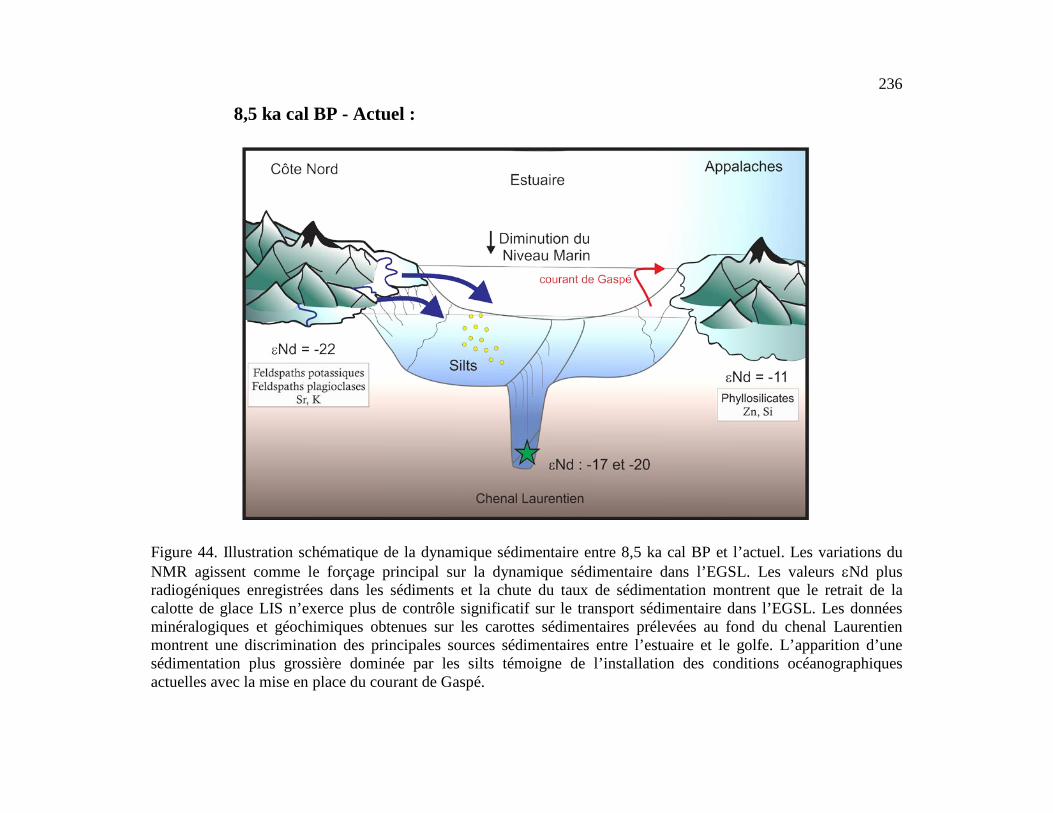
236
Figure 44. Illustration schématique de la dynamique sédimentaire entre 8,5 ka cal BP et l’actuel. Les variations du NMR agissent comme le forçage principal sur la dynamique sédimentaire dans l’EGSL. Les valeurs εNd plus radiogéniques enregistrées dans les sédiments et la chute du taux de sédimentation montrent que le retrait de la calotte de glace LIS n’exerce plus de contrôle significatif sur le transport sédimentaire dans l’EGSL. Les données minéralogiques et géochimiques obtenues sur les carottes sédimentaires prélevées au fond du chenal Laurentien montrent une discrimination des principales sources sédimentaires entre l’estuaire et le golfe. L’apparition d’une sédimentation plus grossière dominée par les silts témoigne de l’installation des conditions océanographiques actuelles avec la mise en place du courant de Gaspé.
8,5 ka cal BP - Actuel :
D’autre part, nos travaux ont permis de mettre en évidence un changement drastique
dans la dynamique sédimentaire à partir de 8,5 ka cal BP. En effet, à partir de 8,5 ka cal BP,
la chute du taux de sédimentation enregistré dans les carottes sédimentaires prélevées au
fond du chenal Laurentien montre que la fonte de la calotte de glace Laurentidienne
n’exerce plus de contrôle sur l’EGSL. Cette hypothèse est confirmée par les valeurs plus
radiogéniques εNd enregistrées dans l’ensemble des sédiments. Ainsi, les variations du
NMR liées au rebond isostatique apparaissent comme le forçage principal sur la dynamique
sédimentaire. Les données de minéralogie et de granulométrie soulignent une
discrimination significative au sein des sources sédimentaires principales à partir de 8,5 ka
cal BP. Dans l’estuaire, les sédiments sont principalement originaires de la Côte Nord, alors
que dans le golfe les sédiments proviennent essentiellement de la chaine des Appalaches.
C’est par l’accomplissement des trois objectifs spécifiques de recherche qu’il a été
possible de réaliser l’objectif principal. Les trois sous-objectifs étaient : 1) établir la
variabilité à long terme de la dynamique sédimentaire dans l’EGSL au cours des derniers
10000 ans, 2) évaluer le potentiel de la composition isotopique en Nd comme traceur de
circulation des masses d’eau profondes et/ou des conditions d’altération continentale dans
l’EGSL, 3) de reconstituer les conditions d’altération continentale dans l’EGSL au cours
des derniers 10000 ans à partir de la composition isotopique en Nd de lixiviats de
sédiments. Les grandes conclusions obtenues dans chacun des sous objectifs seront
détaillées ci-dessous afin de développer la portée scientifique globale du sujet.
EVOLUTION DE LA DYNAMIQUE SEDIMENTAIRE DANS L’ESTUAIRE ET LE
GOLFE DU SAINT-LAURENT DEPUIS 10000 ANS
238
Les analyses de minéralogie, de géochimie, de granulométrie, ainsi que les propriétés
physiques des sédiments menées sur les trois carottes sédimentaires récupérées le long d'un
transect ouest-est dans le chenal Laurentien ont permis de reconstituer l’évolution de la
dynamique sédimentaire dans l’EGSL, à savoir les changements au sein de l’origine et du
transport des sédiments, et cela depuis la dernière déglaciation. Cette analyse multi-traceurs
a permis de mettre en évidence deux régimes sédimentaires distincts au cours de
l’Holocène.
Au début de l’Holocène, le retrait rapide de la calotte de glace Laurentienne vers les
terres a engendré de fortes perturbations au niveau du bassin d’érosion de l’EGSL (Dyke &
Prest 1987). Ainsi, entre 10000 et 8000 ans, l’ensemble des données obtenues sur les trois
carottes sédimentaires soutient l’hypothèse que la fonte de la calotte de glace Laurentienne
est le forçage principal de la dynamique sédimentaire dans l’EGSL. Notre argument est
soutenu par les modèles de déglaciation proposés par Shaw et al. (2002) qui indiquent la
présence de glace sur la Côte-Nord ainsi que sur Terre Neuve au début de l’Holocène. Les
données de minéralogie et de géochimie indiquent des sources sédimentaires communes
pour les sédiments de l’estuaire et du golfe à la fin de la déglaciation. Le ratio
minéralogique Phy/(Plg+Kfs) utilisé pour discriminer les apports sédimentaires provenant
de la Côte-Nord (riches en feldspaths potassiques et plagioclases) par rapport à ceux de la
Côte-Sud (riches en phyllosilicates), révèle des valeurs centrées autour de 1 entre 10 et 8,5
cal ka BP. D’autre part, les propriétés magnétiques des sédiments, indiquées ici par l’indice
Pseudo-S ratio, montrent un mélange entre l’hématite et la magnétite dans les sédiments de
l’EGSL du début de l’Holocène. L’ensemble de ces résultats confirme un mélange des
sources sédimentaires entre la Côte-Nord et la Côte-Sud à la fin de la déglaciation. De plus,
les résultats de granulométrie révèlent la dominance d’argile et de silts fins au début de
l'Holocène dans toutes les carottes sédimentaires. Cette observation est également
confirmée par les faibles valeurs du rapport Zr/Al, indiquant de fortes concentrations en
minéraux fins enrichis en aluminosilicates à la base de toutes les carottes sédimentaires. En

239
s’appuyant sur plusieurs études sédimentologiques (Nota & Loring 1964; Josenhans &
Lehman 1999; St-Onge et al. 2008, 2011), nous proposons l'hypothèse que les décharges
d’eau de fonte provenant de la Côte-Nord associées avec un haut niveau marin (Clark et al.
1978), induisent l'accumulation de sédiments fins dans les zones distales de l'EGSL au
cours de la déglaciation. En effet, les faibles conditions hydrodynamiques dans ce type
d’environnement ont permis des conditions de dépôts moins turbulentes, et par conséquent,
une accumulation préférentielle des minéraux argileux.
La réduction drastique du taux de sédimentation de 300 à 40cm ka-1 observée à ~
8,5 cal ka BP dans les carottes sédimentaires atteste de la forte diminution des processus
d’érosion liés aux importantes décharges d’eau de fonte de la calotte de glace Laurentienne.
En effet, suite à la vidange du lac proglaciaire Agassiz-Ojibway vers la baie d’Hudson et au
retrait de la marge sud-est de la calotte de glace Laurentienne, les variations observées dans
la granulométrie, la minéralogie, la géochimie ainsi qu’au sein des propriétés physiques des
sédiments ont été associées aux changements relatifs du niveau marin suite au rebond
isostatique postglaciaire (Dionne 1977, Clark et al. 1978, Shaw et al. 2002, 2006).
L’ampleur du soulèvement des masses terrestres lié au rebond isostatique postglaciaire
n’était pas uniforme dans le temps et dans l’espace dans la région est du Canada,
engendrant des variations du niveau marin relatif différentes autour de la région de l’EGSL
(Clark et al. 1978). Considérant les variations du niveau marin relatif asynchrones dans
l’EGSL, l’ensemble des données obtenues sur les trois carottes sédimentaires ont été
discutées en fonction de différentes courbes relatives du niveau marin dans le but d’établir
les relations potentielles entre les variations relatives du niveau marin et la dynamique
sédimentaire dans l'EGSL au cours des 8 dernières années. Ainsi, les courbes relatives du
niveau marin sélectionnées pour chacune des carottes sédimentaires montrent une évolution
temporelle similaire avec les traceurs minéralogiques, géochimiques et magnétiques des
sédiments associés. Cette observation constitue une des conclusions majeures de cette
étude, signifiant ainsi que les variations du niveau marin relatif postglaciaires ont exercé un
240
contrôle significatif sur l’évolution de la sédimentation dans l’EGSL au cours des 8000
dernières années. De plus, il apparait une forte discrimination au sein des sources
sédimentaires entre la partie estuarienne et le golf du Saint-Laurent à partir des 8000 ans.
Dans le golfe, la signature minéralogique et géochimique des sédiments détritiques indique
que les sédiments proviennent essentiellement de la Côte-Sud, des provinces maritimes
ainsi que de la Côte-Ouest de Terre Neuve. Au contraire, les sédiments étudiés dans
l’estuaire ont une signature minéralogique, géochimique et magnétique caractéristique des
sédiments provenant de la Côte-Nord.
Pour conclure, les résultats obtenus en réponse à l’objectif 1 indiquent la succession
de deux régimes sédimentaires distincts dans l’EGSL au cours de l'Holocène, qui sont
respectivement associés aux décharges d’eau de fonte de la calotte de glace Laurentienne
(10-8 cal ka BP) ainsi qu’aux changements relatifs du niveau marin postglaciaire (8 cal ka
BP à l’actuel). Une autre façon de compléter cette étude serait de réaliser des analyses sur
la minéralogie des argiles dans l’ensemble des carottes sédimentaires. Plusieurs études ont
mené des analyses à haute résolution temporelle (échelles séculaires à millénaires) sur la
fraction argileuse des sédiments afin d’interpréter les changements climatiques abrupts et
d’identifier les variations au sein des provenances sédimentaires (Bout-Roumazeilles et al.
1999; Montero-Serrano et al. 2009, 2010b). Les provinces géologiques autour de l’EGSL
sont composées de roches caractérisées par différents assemblages minéralogiques,
notamment au niveau des argiles qui peuvent être identifiées par la présence plus ou moins
grande d’illite, de kaolinite, de chlorite et de smectite (Thoby 2014).
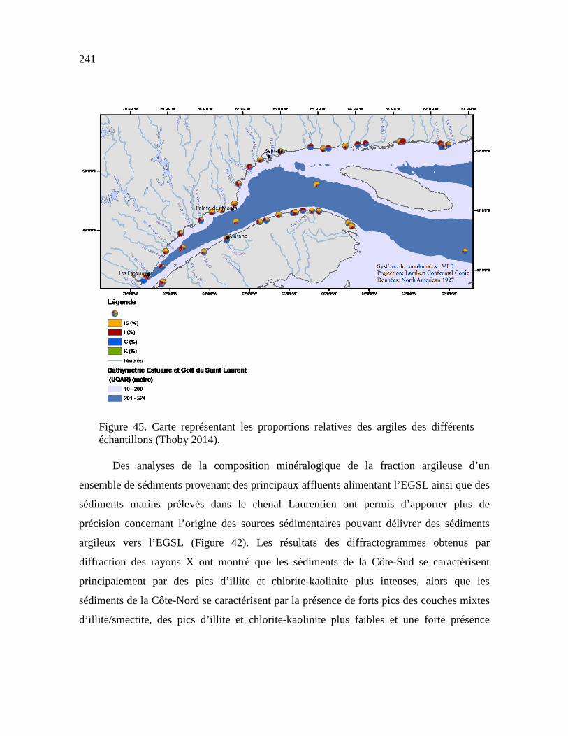
241
Figure 45. Carte représentant les proportions relatives des argiles des différents échantillons (Thoby 2014).
Des analyses de la composition minéralogique de la fraction argileuse d’un
ensemble de sédiments provenant des principaux affluents alimentant l’EGSL ainsi que des
sédiments marins prélevés dans le chenal Laurentien ont permis d’apporter plus de
précision concernant l’origine des sources sédimentaires pouvant délivrer des sédiments
argileux vers l’EGSL (Figure 42). Les résultats des diffractogrammes obtenus par
diffraction des rayons X ont montré que les sédiments de la Côte-Sud se caractérisent
principalement par des pics d’illite et chlorite-kaolinite plus intenses, alors que les
sédiments de la Côte-Nord se caractérisent par la présence de forts pics des couches mixtes
d’illite/smectite, des pics d’illite et chlorite-kaolinite plus faibles et une forte présence

242
d’amphibole et feldspaths (Thoby 2014). Ainsi, en se basant sur ces résultats, l’analyse de
la minéralogie des argiles dans l’ensemble des carottes sédimentaires permettrait de
comparer et de spécifier l’évolution des différentes sources sédimentaires au cours de
l’Holocène.
CALIBRATION DE LA COMPOSITION ISOTOPIQUE EN NÉODYME ET EN STRONTIUM
Les compositions isotopiques en Nd (exprimées en ɛNd) et en Sr obtenues sur les phases
détritiques et authigéniques (oxyhydroxydes de fer et de manganèse) des sédiments marins,
forment de puissants traceurs pour reconstituer les changements au sein de l’origine des
masses d'eau et l’évolution des conditions d’altération continentale à différentes échelles de
temps. Cependant, l'eau de mer étant particulièrement sensible face aux apports
particulaires par les rivières, il a fallu tester l'utilisation de ces outils comme traceurs
paléoceanographiques dans les milieux estuariens. Ainsi, l’étude des concentrations en
REEs et des compositions isotopiques en Nd et en Sr obtenues à partir d'échantillons d'eau
de mer et sur la phase authigénique et détritique des sédiments de surface provenant de
l’EGSL et du plateau continental de l’est du Canada a permis de répondre à l’objectif 2 de
ce projet de recherche.
Les résultats obtenus ont permis de tester la viabilité de la méthode d’extraction des
isotopes sur colonnes chromatographiques à fournir un signal authigénique. Ainsi, les
analyses menées sur les différents échantillons d’eau de mer et sur la phase authigénique
des sédiments de surface ont permis de mettre en évidence un signal isotopique propre à la
colonne d’eau dans l’EGSL, notamment grâce à la signature en Sr caractérisée par un ratio 87Sr/86Sr typique du signal de l’eau de mer actuel (87Sr/86Sr ∼0,70918; Palmer & Elderfield

243
1985; Veizer 1989; Henderson et al. 1994). Les valeurs εNd obtenues sur les échantillons
d’eau de mer (εNd variant de -18,9 ± 0,35 à -21,7 ± 0,35) et sur la phase authigénique des
sédiments de surface (εNd variant de -16,12 ± 0,18 à -27,18 ± 0,23) sont très peu
radiogéniques, et n’illustrent pas les valeurs εNd des masses d’eau profonde dans l’EGSL
(Labrador Current, εNd = −15 à −14; Lacan & Jeandel 2004; Lacan et al. 2012; North
Atlantic Current Water, εNd = −11 à −10; Spivack & Wasserburg 1988; Lacan et al. 2012).
Sur la base de ces résultats, il apparait que le signal isotopique authigénique en Nd obtenu
dans l’EGSL est avant tout le résultat de l’érosion et de l’altération des roches détritiques
du bouclier canadien, notamment de la province de Grenville. Les particules provenant de
la Côte-Nord sont essentiellement amenées dans l’EGSL par les rivières. Les profils de
concentrations en REEs et la composition isotopique en Nd obtenus dans la colonne d’eau
suggèrent que les processus de scavenging contrôlent la distribution des éléments traces
dans l’EGSL. En effet, la forte corrélation entre la répartition verticale des concentrations
en Nd et la distribution de la matière particulaire en suspension soutient l’idée que les REEs
dissous sont adsorbés sur les particules en suspension et ainsi soustrait à la colonne d’eau
sous forme d’agrégats. De plus, la formation de glace de mer en hiver dans l’EGSL entraine
un rejet de sel qui peut jouer un rôle significatif sur la distribution de la composition
isotopique en Nd dans la colonne d’eau (Haley & Polyak 2013; Haley et al. 2008). En effet,
l’écoulement des eaux salées plus denses de la surface vers le fond provoque des processus
d’homogénéisation, notamment au niveau de la composition isotopique en Nd dans les
masses d’eau du Saint-Laurent.
La comparaison de la signature εNd obtenue sur la fraction détritique et
authigénique des sédiments de surface avec celle des masses d’eau sus-jacentes suggère que
le signal isotopique propre aux masses d’eau LCW/NACW est masqué par la signature εNd
continentale délivrée par les particules en suspension transportées par les rivières. Dans ce
contexte, la composition isotopique en Nd extraite sur la fraction authigénique des
sédiments de surface révèle que le εNd peut être utilisé comme traceur des conditions

244
d’altération et d’érosion continentales. D’autre part, les valeurs εNd et les rapports 87Sr/86Sr, La/Yb et Gd/Yb obtenus sur les sédiments détritiques de surface permettent
d’identifier trois sources sédimentaires distinctes. Premièrement, les sédiments provenant
du plateau continental et de la Baie des Chaleur ont une signature isotopique estimée à 61%
d’origine Appalachienne, et les 39% restant caractérisant les sédiments de la province de
Grenville. Les sédiments prélevés au niveau du chenal Laurentien et du chenal Esquiman
enregistrent les mêmes caractéristiques isotopiques que les roches provenant de la province
de Grenville sur la Côte-Nord. Ceci n’est pas surprenant car l’apport principal de Nd très
peu radiogénique dans l’EGSL est majoritairement délivré par l’érosion des roches
provenant du bouclier canadien (Farmer et al. 2003). Ainsi les sédiments provenant du
chenal Laurentien et du chenal Esquiman sont caractérisés par un mélange d’environ 86%
originaire de la province de Grenville et de 14% de la chaine des Appalaches. Enfin,
l’échantillon sédimentaire provenant de la zone sud du plateau continental du Labrador est
caractérisé par une valeur εNd très peu radiogénique (εNd = -28,7) correspondant aux
signatures isotopiques caractéristiques du détroit d’Hudson et de la baie de Baffin (Farmer
et al. 2003). Cette valeur très faible en εNd peut être associée aux apports en Nd peu
radiogéniques transportés par le courant du Labrador.
Pour conclure, les résultats obtenus en réponse à l’objectif 2 prouvent que les
compositions isotopiques en néodyme obtenues dans les fractions authigéniques et
détritiques des sédiments de l’EGSL et du plateau continental est-canadien forment de très
bons traceurs pour établir les conditions d’altération continentales et retracer les différentes
sources sédimentaires. Ces résultats renforcent les travaux de Lambelet et al. 2015 et
Filippova et al. 2017 qui ont montré que la composition isotopique en Nd obtenue sur
différentes masses d’eau de l’Atlantique Nord pouvait être fortement influencée par les
apports de particules terrigènes issues des marges continentales avoisinnantes. Notre étude
fournie une base solide pour évaluer la signature isotopique en Nd préservée dans les
carottes sédimentaires de l’EGSL de façon à reconstituer et documenter l’évolution et
245
l’origine des apports sédimentaires en lien avec les changements climatiques,
particulièrement lors de la déglaciation, lorsque les décharges d’eau de fonte de la calotte
de glace Laurentienne ont grandement influencé la dynamique sédimentaire. Les résultats
obtenus au cours de cette étude ont montré que la composition isotopique en Nd obtenue
dans les masses d’eau de l’EGSL n’était pas en mesure de fournir le signal authigénique
spécifique aux masses d’eau profonde (LC vs. NACW). Sur cette base, il est difficile de
reconstituer la variabilité et l’origine des masses d’eau dans l’EGSL grâce aux isotopes du
Nd dans l’EGSL. Pour obtenir le signal εNd spécifique aux masses d’eau qui pénètrent
dans l’EGSL par le détroit de Cabot, il pourrait être judicieux de prélever plusieurs
échantillons d’eau de mer et de sédiments de surface, à différentes profondeurs, le long
d’un transect est-ouest à l’entrée du détroit du Cabot. Ainsi, nous pourrions voir si la
présence du plateau continental caractérisé par une bathymétrie peu profonde est un facteur
limitant à l’obtention du signal εNd caractéristique des masses d’eau. Une telle étude
permettrait de mettre en évidence les processus géochimiques intervenant à l’interface entre
deux milieux (plus connu sous le nom « boundary exchange »; Jeandel et al. 2013; Rickli et
al. 2014; Lambelet et al. 2016), notamment les interactions spécifiques entre les masses
d’eau et les sédiments de surface en bordure des marges continentales. En effet, les marges
continentales forment des zones privilégiées pour la soustraction d’éléments chimiques
réactifs, qui peuvent être libérés des sédiments et des particules auxquels ils se sont
accrochés pour être transportés vers le large. De cette façon, des échanges d’éléments
chimiques qualifiés d’insolubles entre les zones côtières et les océans ouverts sont
possibles. Ce phénomène semble majeur à l’échelle mondiale car il a déjà été constaté sur
différentes marges continentales avec un contexte géologique, climatique et biologique
différent (Lacan & Jeandel 2005a). Comprendre ces échanges permettrait de mettre en
évidence les processus géochimiques et les flux de matière à l’interface continent/océan, ce
qui est essentiel pour comprendre les interactions entre la chimie de l'océan et le climat.
D’autre part, il pourrait être pertinent d’analyser les concentrations des particules terrigènes
246
transportées par les rivières. En effet, de telles analyses permettraient de comprendre
l’importance que jouent les rivières dans l’acheminement des particules jusqu’au milieu
estuarien, et de mettre en évidence les processus bio-géochimiques majeurs pouvant
intervenir au niveau des échanges particulaires entre les rivières et l’EGSL.
ISOTOPES RADIOGÉNIQUES ET CONCENTRATIONS EN ELEMENTS
TRACES ET TERRES RARES COMME TRACEURS DE SOURCES
CONTINENTALES DANS L’EGSL
Pour répondre au troisième sous-objectif de cette thèse, les concentrations en éléments
traces ainsi que les compositions isotopiques en Nd et Sr de deux carottes sédimentaires
prélevées dans l’estuaire (COR0602-36PC) et dans le golfe (COR0503-CL04-36PC) du
Saint-Laurent ont été analysées afin de comprendre l’évolution du transport, de l’origine et
de la dynamique sédimentaire des sédiments détritiques dans l’EGSL au cours de
l’Holocène. Les compositions isotopiques authigéniques en Nd obtenues dans les sédiments
de l'EGSL soutiennent l'idée que les variations du signal radiogénique ɛNd ne sont pas
contrôlées par des changements au sein de la provenance des masses d'eau profondes. En
effet, la signature ɛNd authigénique reflète plutôt le signal isotopique des continents
adjacents, notamment en raison de l’érosion et de l’altération des roches métamorphiques
composant le bouclier canadien sur la Côte-Nord, et dans une moindre mesure, des roches
sédimentaires Paléozoïque de la chaine des Appalaches. Les concentrations en éléments
traces et terres rares et les compositions isotopiques en Nd et Sr ont été comparées avec les
résultats de minéralogie et de géochimie préalablement obtenus sur les mêmes carottes
sédimentaires (cf Chapitre 1). Ainsi, la combinaison de l’ensemble des différents traceurs a
permis de mettre en évidence avec robustesse deux régimes sédimentaires distincts au cours
de l’Holocène, réitérant ainsi l’hypothèse soutenue dans l’objectif 1.
247
(1) Au début de l’Holocène (10–8,5 cal ka BP), les signatures en ɛNd obtenues sur
la phase authigénique des sédiments montrent une composition isotopique
particulièrement faible, avec une valeur moyenne ɛNd de -24,3 ± 0,1 et de -21,4
± 0,2 pour les carottes de l’estuaire et du golfe, respectivement. Ces valeurs très
peu radiogéniques associées aux taux de sédimentation élevés (~ 300 cm ka-1;
Barletta et al. 2010) suggèrent que les sédiments sont principalement délivrés
par l’érosion et l’altération des roches de la Côte-Nord. En effet, les décharges
d’eau de fontes liées au retrait de la calotte de glace Laurentienne conduisent à
une forte altération et érosion des roches métamorphiques constituant le bouclier
canadien (ɛNd = -32 à -22; Farmer et al. 2003; Pratte et al. 2017), expliquant les
signatures ɛNd très peu radiogéniques enregistrées dans les sédiments.
(2) Depuis 8,5 cal ka BP, la fonte de la calotte de glace laurentienne n’exerce plus
d’influence sur la dynamique sédimentaire dans l’EGSL. En effet, la chute des
taux de sédimentation de 300 à 40 cm ka-1 observée à 8,5 cal ka BP atteste d’une
diminution drastique des processus d’érosion dans l’EGSL en lien avec le
déversement des décharges d’eau de fonte de la calotte de glace Laurentienne
vers la baie d’Hudson (St-Onge et al. 2003, 2011). Dès lors, les variations
relatives du niveau marin liées au rebond isostatique post glaciaire apparaissent
comme étant le forcage principal exercant un contrôle sur la dynamique
sédimentaire dans l’EGSL. Ainsi, à partir de ce moment, une discrimination
significative des sources sédimentaires apparait entre l’estuaire et le golfe. Dans
l’estuaire, un fort enrichissement en LREE (HREE/LREE = 0,39) et une
anomalie négative en europium (Eu/Eu* = 0,86) indique que la Côte-Nord est la
principale source sédimentaire. De façon inverse, les sédiments du golfe sont
caractérisés par une faible anomalie positive en europium (Eu/Eu* = 1,02) et un

248
fort ratio HREE/LREE (= 0,47) attestant que les sédiments sont principalement
délivrés par la chaine des Appalaches et par les provinces maritimes, notamment
grâce à la branche sud du courant de Gaspé.
D’autre part, l’absence de variations significatives au sein des différents traceurs
détritiques depuis 8 cal ka BP suggère que l’établissement des conditions de sédimentation
modernes dans l’EGSL s’est mis en place au cours de l’Holocène moyen. Ainsi, il apparait
que les compositions isotopiques authigéniques en Nd et que la distribution des REE
constituent des puissants traceurs pour évaluer l’évolution des différentes sources
sédimentaires au cours du temps, et pour identifier les principaux forçages climatiques
et/ou océanographiques exercant un contrôle sur la dynamique sédimentaire dans l’EGSL.
Dans le but d’approfondir cette étude paléoclimatique et de mieux caractériser les
différentes sources sédimentaires, il pourrait être pertinent d’analyser les compositions
isotopiques en plomb (Pb) et en hafnium (Hf) dans les sédiments de l’EGSL. En effet, en
complément des isotopes du Nd, les isotopes du Pb pourraient être utilisés pour évaluer le
degré de mélange des différentes sources sédimentaires de même que la contribution de
l'érosion continentale (ex., Piepgras et al. 1984; Piepgras & Wasserburg 1987; Goldstein &
O'Nions 1981; Albarède & Goldstein 1992 ; Reynolds et al. 2006).
Dans l'eau de mer, le Pb est une particule hautement réactive avec un temps de
résidence de l'ordre de 20 à 30 ans dans l'océan Atlantique (Henderson & Maier Reimer
2002), ce qui est significativement plus court que le temps de circulation des masses d’eau
de l’océan Atlantique et de la circulation thermohaline globale. Ainsi, en raison de son
temps de résidence tres court dans l'eau de mer, le Pb n'est pas transporté sur de longues
distances ou entre différents bassins océaniques. De plus, les apports de particules par les
rivières jouent un rôle tres important dans le budget du Pb océanique (Frank et al. 2002).
Ainsi, les enregistrements isotopiques du Pb dissous dans l’eau de mer et dans les

249
sédiments marins constituent des archives essentielles pour reconstituer l’évolution des
apports continentaux locaux (Frank 2002; van de Flierdt et al. 2003; Foster & Vance 2006)
(Figure 43). Les isotopes radiogéniques lourds tels que le Pb, ont la particularité de ne pas
être affectés par la température et l'activité biologique du milieu leur permettant de garder
la signature de la roche mère (Revel et al. 1996).
Figure 46. Identification des sources continentales potentielles de Pb à partir des ratios isotopiques 208Pb/204Pb vs 206Pb/204Pb (modifié de Foster & Vance 2006).
D’autre part, les analyses combinées des isotopes du Nd et du Hf sont largement
utilisées pour identifier les différents réservoirs terrestres (van de Flierdt et al. 2007) et
pour comprendre les processus d’érosion sur les roches silicatées (Bayon et al. 2009). Le
Hf présente un grand potentiel en tant que traceur paléocéanographique car les roches
continentales exposent une gamme tres variée de compositions isotopiques et, par
250
conséquent, l'eau de mer est tres sensible aux variations des apports continentaux
(Piotrowski et al. 2000). A l'échelle mondiale, les deux systèmes isotopiques Lu–Hf et Sm–
Nd ont un comportement identique lors des processus de fusion partielle expliquant ainsi
leur forte correlation dans les roches silicatés (Vervoot et al. 1999). Ceci est clairement
illustré par la corrélation positive entre les isotopes du Nd et du Hf, caractérisée par la «
zone terrestre» (Vervoort et al. 1999), définie par la plupart des basaltes océaniques, des
roches de la croute continentale et de l’ensemble des sédiments (Bayon et al. 2009; Vervoot
et al. 1999). Cependant, des différences significatives entre les couples géochimiques Lu-
Hf et Sm-Nd apparaissent à l'échelle minérale. Alors que Sm et Nd sont incorporés dans
des proportions similaires dans la plupart des minéraux, Lu et Hf sont répartis différemment
dans chaque phase minérale (Bayon et al. 2009). Un fractionnement relativement important
entre Lu et Hf apparait lors de la cristallisation magmatique, qui en fontion du temps et de
la désintégration radioactive de 176Lu en 176Hf conduit à des signatures isotopiques en Hf
tres différentes dans les minéraux. Ce découplage entre les couples géochimique Lu-Hf et
Sm-Nd à l'échelle minérale permet donc de retracer les variations des processus d’érosion,
avec des processus qui n’affectent pas l’ensemble de la roche de façon uniforme, mais
seulement des phases minérales spécifiques (Bayon et al. 2009). De plus, plusieurs études
ont montré que les encroutements de fer et de manganese reflètent de maniere fiable la
composition isotopique en Hf de l’eau de mer (David et al. 2001; Van de Flierdt et al.
2004; Bau & Koschinsky 2006). Cependant, dans les encroutements de fer et de
manganese, les rapports isotopiques en Hf sont plus élevés pour une composition
isotopique en Nd donnée (Albarède et al. 1998). Le découplage observé entre le Hf et Nd
est du à la préservation préférentielle du Hf trés peu radiogénique dans les minéraux trés
résistants aux processus d’érosion (comme par exemple, les zircons; Piotrowski et al.
2000). En effet, contrairement au Nd, le Hf est libéré de manière incongruente lors des
processus d’érosion (Patchett et al. 1984), c’est-à-dire que les différents éléments
chimiques qui composent le minéral se dissolvent de manière différentielle lors des

251
processus d’érosion. Ainsi, l’altération incongruente du Hf permet d’expliquer le décalage
observé entre les signatures obtenues sur les encroûtements de fer et de manganèse
(Albarède et al. 1998; David et al. 2001) et celles obtenues dans la croute continentale et
dans les roches mantelliques (Vervoort et al. 1999) (Figure 46).
Figure 47. Comparaison des rapports isotopiques εNd et εHf dans différents réservoirs terrestres. La compilation des données obtenue a partir de roches mantelliques, de la croute continentale ainsi que sur des encroutements de fer et de manganèse et sur des échantillons d’eau de mer a permis de mettre en évidence une zone « eau de mer » et une « zone terrestre » (Godfrey et al. 1997 ; Vervoort et al. 1999 ; Albarède et al. 1998 ; David et al. 2001 ; Frank et al. 2002).
Finalement, la croûte continentale composant le bouclier canadien, qui représente
une des principales sources sédimentaires détritiques pour la région Nord-Ouest de l’océan
252
Atlantique, héberge une grande quantité de Hf très peu radiogénique qui est libéré dans
l'océan principalement au cours des périodes d’intense érosion comme pendant les périodes
glaciaires ou post-glaciaires (Patchett et al. 1984; Piotrowski et al. 2000; Van de flierdt
2002, 2004). Par conséquent, la combinaison des isotopes du Nd et du Hf dans la fraction
authigénique des sédiments marins de l’EGSL pourrait former un outil puissant pour
évaluer les changements d’intensité des processus d’altérion et d’érosions passés,
notamment lors des phases d’intenses érosions observées au début de l’Holocène dues aux
fortes décharges d’eau de fonte de la calotte de glace Laurentienne.
Enfin, les variations observées au sein de nos enregistrements sédimentaires pourraient être
comparées et possiblement associées à la variabilité climatique intra-Holocène sur des
échelles de temps plus ou moins longues (séculaires à décennales). Il est aujourd’hui très
bien reconnu dans la littérature que la période Holocène qui semble stable d’un point de vu
climatique, révèle en réalité une variabilité climatique très riche (Debret et al., 2008 ;
Mayewski et al. 2004 ; Magny, 2004 ; Masson et al., 2000; Migowski et al., 2006 ; Schulz
& Paul, 2002). Cette variabilité peut trouver différentes origines dépendamment qu’elle soit
générée par des forçage externe, ou au contraire, par des forçages d’origine interne au
système climatique. Dans le cas des forçages externes, l’activité solaire et l’insolation sont
les principaux paramètres ayant une influence sur le climat. Dans le cas des forçages
internes, plusieurs phénomènes tels que les effets de seuil ou les boucles de rétroactions
peuvent ajuster et modifier le forçage original. Ainsi, la variabilité climatique holocène
dans l’EGSL mise en évidence grâce à l’ensemble des paramètres physiques,
géochimiques, minéralogiques et granulométriques obtenus sur les sédiments marins du
chenal laurentien pourrait être davantage caractérisée par des analyses en ondelettes
(Debret et al., 2007, 2008). En effet, l’utilisation des analyses en ondelettes sur des
enregistrements marins permettrait d’étendre l’analyse des forçages internes et externes du
climat (Debret et al., 2007, 2008). Ainsi, nous pourrions définir si des phénomènes très bien
253
reconnus dans l’Atlantique Nord, comme par exemple l’Oscillation Nord Atlantique
(NAO), exercent un rôle sur la variabilité climatique holocène dans l’EGSL.

254
ANNEXE 1
Figure 48. Comparison of magnetic susceptibility profiles of cores MD99-2221 and COR0602-36PC. Correlative magnetic features are indicated. The last age-depth point of core MD99-2221 was used in the age model of core COR0602-36PC.

255
ANNEXE 2
Figure 49. Vertical distribution of the bulk mineralogical and geochemical data obtained on the sedimentary cores COR0503-CL04-36PC (A-B), COR0503-CL05-37PC (C-D) and COR0602-36PC (E-F).
ANNEXE 3
Tableau 4. REE concentrations from the five seawater stations (pmol/kg) and from the detrital (ppm) and authigenic (ppb) phase of marine sediments. REE were normalized to Post Archaean Australian Shale (Pourmand et al. 2012).

ANNEXE 4
Tableau 5. Neodymium and strontium isotope composition obtained from the five seawater stations and from leached and detrital sediments.

ANNEXE 5
Tableau 6. REE concentrations obtained from the authigenic phase of the two sediment cores COR0602-36PC (estuary) and COR0503-CL04-36PC (gulf). The ratio (HREE/LREE)n= (Tm+Yb+Lu)n/(La+Ce+Pr+Nd)n, (MREE)*n=(2[Gd+Tb+Dy]n/[HREE+LREE]n) and (Eu/Eu*)n = (2*Eu)n/(Sm+Ga)n are reported. All the REE were normalized to Post Archaean Australian Shale (PAAS, Pourmand et al. 2012).

ANNEXE 6
Tableau 7. Neodymium and strontium isotopic composition obtained from the bulk leached sediments of the two sedimentary cores COR0602-36PC (estuary) and COR0503-CL04-36PC (gulf).
RÉFÉRENCES BIBLIOGRAPHIQUES
Aitchison, J., 1986. The statistical analysis of compositional data.
Aitchison, J., 1990. Relative variation diagrams for describing patterns of compositional variability. Mathematical Geology 22, 487–511. doi:10.1007/BF00890330
Albarède, F., Goldstein, S.L., 1992. World map of Nd isotopes in sea-floor ferromanganese deposits. Geology 20, 761. doi:10.1130/0091-7613(1992)020<0761:WMONII>2.3.CO;2
Albarède, F., Simonetti, A., Vervoort, J.D., Blichert-Toft, J., Abouchami, W., 1998. A Hf-Nd isotopic correlation in ferromanganese nodules. Geophysical Research Letters 25, 3895–3898. doi:10.1029/1998GL900008
Allègre, C., 1996. Sr-Nd-Pb isotope systematics in Amazon and Congo River systems: constraints about erosion processes. Chemical Geology 131, 93–112. doi:10.1016/0009-2541(96)00028-9
Arsouze, T., Dutay, J.-C., Lacan, F., Jeandel, C., 2009. Reconstructing the Nd oceanic cycle using a coupled dynamical – biogeochemical model. Biogeosciences 6, 2829–2846. doi:10.5194/bg-6-2829-2009
Arsouze, T., Dutay, J.-C., Lacan, F., Jeandel, C., 2007. Modeling the neodymium isotopic composition with a global ocean circulation model. Chemical Geology 239, 165–177. doi:10.1016/j.chemgeo.2006.12.006
Babin, M., Therriault, J.-C., Legendre, L., Nieke, B., Reuter, R., Condal, A., 1995. Relationship between the maximum quantum yield of carbon fixation and the minimum quantum yield of chlorophyll a in vivo fluorescence in the Gulf of St. Lawrence. Limnology and Oceanography 40, 956–968. doi:10.4319/lo.1995.40.5.0956

261
Bard, E., 1998. Geochemical and geophysical implications of the radiocarbon calibration. Geochimica et Cosmochimica Acta 62, 2025–2038. doi:10.1016/S0016-7037(98)00130-6
Barletta, F., St-Onge, G., Stoner, J.S., Lajeunesse, P., Locat, J., 2010. A high-resolution Holocene paleomagnetic secular variation and relative paleointensity stack from eastern Canada. Earth and Planetary Science Letters 298, 162–174. doi:10.1016/j.epsl.2010.07.038
Bayon, G., Burton, K.W., Soulet, G., Vigier, N., Dennielou, B., Etoubleau, J., Ponzevera, E., German, C.R., Nesbitt, R.W., 2009. Hf and Nd isotopes in marine sediments: Constraints on global silicate weathering. Earth and Planetary Science Letters 277, 318–326. doi:10.1016/j.epsl.2008.10.028
Bayon, G., German, C.R., Boella, R.M., Milton, J.A., Taylor, R.N., Nesbitt, R.W., 2002. An improved method for extracting marine sediment fractions and its application to Sr and Nd isotopic analysis. Chemical Geology 187, 179–199.
Bayon, G., German, C.R., Burton, K.W., Nesbitt, R.W., Rogers, N., 2004. Sedimentary Fe–Mn oxyhydroxides as paleoceanographic archives and the role of aeolian flux in regulating oceanic dissolved REE. Earth and Planetary Science Letters 224, 477–492. doi:10.1016/j.epsl.2004.05.033
Bernatchez, P., Université du Québec à Rimouski, Laboratoire de dynamique et de gestion intégrée des zones côtières, 2008. Sensibilité des côtes et vulnérabilité des communautés du golfe du Saint-Laurent aux impacts des changements climatiques. Laboratoire de dynamique et de gestion intégrée des zones côtières, Université du Québec à Rimouski, Rimouski.
Bertram, C.J., Elderfield, H., Aldridge, R.J., Conway Morris, S., 1992. 87Sr/86Sr, 143Nd/144Nd and REEs in Silurian phosphatic fossils. Earth and Planetary Science Letters 113, 239–249. doi:10.1016/0012-821X(92)90222-H
Bau, M., Koschinsky, A., 2006. Hafnium and neodymium isotopes in seawater and in ferromanganese crusts: The “element perspective”. Earth and Planetary Science Letters 241, 952–961. doi:10.1016/j.epsl.2005.09.067
Blaauw, M., Christen, J.A., 2011. Flexible paleoclimate age-depth models using an autoregressive gamma process. Bayesian Analysis 6, 457–474. doi:10.1214/11-BA618
262
Blott, S.J., Pye, K., 2001. GRADISTAT: a grain size distribution and statistics package for the analysis of unconsolidated sediments. Earth Surface Processes and Landforms 26, 1237–1248. doi:10.1002/esp.261
Bourgault, D., Cyr, F., Galbraith, P.S., Pelletier, E., 2012. Relative importance of pelagic and sediment respiration in causing hypoxia in a deep estuary. Journal of Geophysical Research: Oceans 117, 1978–2012.
Bourgault, D., Koutitonsky, V.G., 1999. Real‐time monitoring of the freshwater discharge at the head of the St. Lawrence Estuary. Atmosphere-Ocean 37, 203–220. doi:10.1080/07055900.1999.9649626
Bout-Roumazeilles, V., Cortijo, E., Labeyrie, L., Debrabant, P., 1999. Clay mineral evidence of nepheloid layer contributions to the Heinrich layers in the northwest Atlantic. Palaeogeography, Palaeoclimatology, Palaeoecology 146, 211–228.
Braun, J.-J., Viers, J., Dupré, B., Polve, M., Ndam, J., Muller, J.-P., 1998. Solid/Liquid REE Fractionation in the Lateritic System of Goyoum, East Cameroon: The Implication for the Present Dynamics of the Soil Covers of the Humid Tropical Regions. Geochimica et Cosmochimica Acta 62, 273–299. doi:10.1016/S0016-7037(97)00344-X
Broecker, W.S., Peng, T.-H., Beng, Z., 1982. Tracers in the Sea. Lamont-Doherty Geological Observatory, Columbia University.
Bugden, G. L., 1991. Changes in the temperature-salinity characteristics of the deeper waters of the Gulf of St. Lawrence over the past several decades. Can. Spec. Publ. Fish. Aquat. Sci., J.-C.
Casse, M., Montero-Serrano, J.-C., St-Onge, G., 2017. Influence of the Laurentide Ice Sheet and relative sea-level changes on sediment dynamics in the Estuary and Gulf of St. Lawrence since the last deglaciation. Boreas. doi:10.1111/bor.12230
Cauchon-Voyer, G., Locat, J., Leroueil, S., St-Onge, G., Demers, D., 2011. Large-scale subaerial and submarine Holocene and recent mass movements in the Betsiamites area, Quebec, Canada. Engineering Geology 121, 28–45. doi:10.1016/j.enggeo.2011.04.011
Cazenave, A., Cozannet, G.L., 2014. Sea level rise and its coastal impacts. Earth’s Future 2, 15–34. doi:10.1002/2013EF000188

263
Chen, T.-Y., Frank, M., Haley, B.A., Gutjahr, M., Spielhagen, R.F., 2012. Variations of North Atlantic inflow to the central Arctic Ocean over the last 14 million years inferred from hafnium and neodymium isotopes. Earth and Planetary Science Letters 353, 82–92. doi:10.1016/j.epsl.2012.08.012
Clark, J.A., Farrell, W.E., Peltier, W.R., 1978. Global changes in postglacial sea level: A numerical calculation. Quaternary Research 9, 265–287. doi:10.1016/0033-5894(78)90033-9
Cloutier, V., Lefebvre, R., Therrien, R., Savard, M.M., 2008. Multivariate statistical analysis of geochemical data as indicative of the hydrogeochemical evolution of groundwater in a sedimentary rock aquifer system. Journal of Hydrology 353, 294–313. https://doi.org/10.1016/j.jhydrol.2008.02.015
Copard, K., Colin, C., Frank, N., Jeandel, C., Montero-Serrano, J.-C., Reverdin, G., Ferron, B., 2011. Nd isotopic composition of water masses and dilution of the Mediterranean outflow along the southwest European margin: Nd isotopic composition of water masses. Geochemistry, Geophysics, Geosystems 12. doi:10.1029/2011GC003529
D’Anglejan, B.F., Smith, E.C., 1973. Distribution, transport, and composition of suspended matter in the St. Lawrence estuary. Canadian Journal of Earth Sciences 10, 1380–1396.
D’Anglejan, B.F., 1969. Preliminary observations on suspended matter in the the Gulf of St. Lawrence. Maritime sediments 15–18.
D’Anglejan, B.F., 1990. Recent sediments and sediment transport processes in the St. Lawrence estuary. In Oceanography of a Large-Scale Estuarine System, pp. 109-129). Springer, New York, NY.
David, K., Frank, M., O’Nions, R.., Belshaw, N.., Arden, J., 2001. The Hf isotope composition of global seawater and the evolution of Hf isotopes in the deep Pacific Ocean from Fe–Mn crusts. Chemical Geology 178, 23–42. doi:10.1016/S0009-2541(00)00427-7
De Vernal, A., St-Onge, G., Gilbert, D., 2011. Oceanography and Quaternary geology of the St. Lawrence Estuary and the Saguenay Fjord. IOP Conference Series: Earth and Environmental Science 14, 012004. doi:10.1088/1755-1315/14/1/012004
264
Debret, M., 2008. Caractérisation de la variabilité climatique Holocène à partir de séries continentales, marines et glaciaires. Doctoral dissertation, Université Joseph-Fourier-Grenoble I.
Debret, M., Bout-Roumazeilles, V., Grousset, F., Desmet, M., McManus, J. F., Massei, N., ... & Trentesaux, A., 2007. The origin of the 1500-year climate cycles in Holocene North-Atlantic records. Climate of the Past Discussions 3(2), 679-692.
Debret, M., Sebag, D., Desmet, M., Balsam, W., Copard, Y., Mourier, B., Susperrigui, A.-S., Arnaud, F., Bentaleb, I., Chapron, E., Lallier-Vergès, E., Winiarski, T., 2011. Spectrocolorimetric interpretation of sedimentary dynamics: The new “Q7/4 diagram”. Earth-Science Reviews 109, 1–19. doi:10.1016/j.earscirev.2011.07.002
DePaolo, D.J., Wasserburg, G.J., 1976. Nd isotopic variations and petrogenetic models. Geophysical Research Letters 3, 249–252. doi:10.1029/GL003i005p00249
Dickie, L.M., Trites, R.W., 1983. The Gulf of St. Lawrence, dans Estuaries and enclosed seas.
Dietze, E., Hartmann, K., Diekmann, B., IJmker, J., Lehmkuhl, F., Opitz, S., Stauch, G., Wünnemann, B., Borchers, A., 2012. An end-member algorithm for deciphering modern detrital processes from lake sediments of Lake Donggi Cona, NE Tibetan Plateau, China. Sedimentary Geology 243, 169–180. doi:10.1016/j.sedgeo.2011.09.014
Dionne, J., 1993. Long-term rates of vertical accretion and modern erosion of tidal marshes of a so-called emerging shoreline, St. Lawrence estuary, Québec. Presented at the Abstracts: Symposium on sediment dynamics, deposition and erosion in temperate salt marshes. International Geographic Union, Commission on Coastal Systems, Manuscript, p. 8.
Dionne, J.-C., 1977. La mer de Goldthwait au Québec. Géographie physique et Quaternaire 31, 61. doi:10.7202/1000055ar
Dionne, J.-C., 2002. Chapter Nineteen Sediment content of the ice-cover in muddy tidal areas of the turbidity zone of the St. Lawrence estuary and the problem of the sediment budget, in: Proceedings in Marine Science. Elsevier, pp. 463–478.

265
Drapeau, G., 1990. Nearshore sediment dynamics in the St. Lawrence estuary. In Oceanography of a large-scale estuarine system (pp. 130-154). Springer, New York, NY.
Drinkwater, K.F., Gilbert, D., 2004. Hydrographic Variability in the Waters of the Gulf of St. Lawrence, the Scotian Shelf and the Eastern Gulf of Maine (NAFO Subarea 4) During 1991-2000. Journal of Northwest Atlantic Fishery Science 34, 85–101. doi:10.2960/J.v34.m545
Du, J., Haley, B.A., Mix, A.C., 2016. Neodymium isotopes in authigenic phases, bottom waters and detrital sediments in the Gulf of Alaska and their implications for paleo-circulation reconstruction. Geochimica et Cosmochimica Acta 193, 14–35. doi:10.1016/j.gca.2016.08.005
Duchesne, M.J., Bellefleur, G., Commission géologique du Canada, 2007. Processing of single-channel, high-resolution seismic data collected in the St. Lawrence estuary, Quebec. Ressources naturelles Canada, Ottawa.
Duchesne, M.J., Pinet, N., Bédard, K., St-Onge, G., Lajeunesse, P., Campbell, D.C., Bolduc, A., 2010. Role of the bedrock topography in the Quaternary filling of a giant estuarine basin: the Lower St. Lawrence Estuary, Eastern Canada. Basin Research. doi:10.1111/j.1365-2117.2009.00457.x
Dupré, B., Gaillardet, J., Rousseau, D., Allègre, C.J., 1996. Major and trace elements of river-borne material: The Congo Basin. Geochimica et Cosmochimica Acta 60, 1301–1321. doi:10.1016/0016-7037(96)00043-9
Dyke, A.S., 2004. An outline of North American deglaciation with emphasis on central and northern Canada. Developments in Quaternary Sciences 2, 373–424.
Dyke, A.S., Peltier, W.R., 2000. Forms, response times and variability of relative sea-level curves, glaciated North America. Geomorphology 32, 315–333.
Dyke, A.S., Prest, V.K., 1987. Late Wisconsinan and Holocene History of the Laurentide Ice Sheet. Géographie physique et Quaternaire 41, 237. doi:10.7202/032681ar
266
Ebbestad, J.O.R., Tapanila, L., 2005. Non-predatory borings in Phanerotrema (Gastropoda), Early Silurian, Anticosti Island, Québec, Canada. Palaeogeography, Palaeoclimatology, Palaeoecology 221, 325–341. doi:10.1016/j.palaeo.2005.03.003
El-Sabh, M.I., Silverberg, N., 1990. Oceanography of a large-scale estuarine system: the St. Lawrence, Coastal and estuarine studies 39. Springer-Verlag, New York, 71-93.
Elderfield, H., Gieskes, J.M., Baker, P.A., Oldfield, R.K., Hawkesworth, C.J., Miller, R., 1982. 87Sr/86Sr and 18O/16O ratios, interstitial water chemistry and diagenesis in deep-sea carbonate sediments of the Ontong Java Plateau. Geochimica et Cosmochimica Acta 46, 2259–2268. doi:10.1016/0016-7037(82)90199-5
Elderfield, H., Upstill-Goddard, R., Sholkovitz, E.R., 1990. The rare earth elements in rivers, estuaries, and coastal seas and their significance to the composition of ocean waters. Geochimica et Cosmochimica Acta 54, 971–991. doi:10.1016/0016-7037(90)90432-K
Fagel, N., Not, C., Gueibe, J., Mattielli, N., Bazhenova, E., 2014. Late Quaternary evolution of sediment provenances in the Central Arctic Ocean: mineral assemblage, trace element composition and Nd and Pb isotope fingerprints of detrital fraction from the Northern Mendeleev Ridge. Quaternary Science Reviews 92, 140-154. doi:10.1016/j.quascirev.2013.12.011
Farmer, G.L., Barber, D., Andrews, J., 2003. Provenance of Late Quaternary ice-proximal sediments in the North Atlantic: Nd, Sr and Pb isotopic evidence. Earth and Planetary Science Letters 209, 227–243. doi:10.1016/S0012-821X(03)00068-2
Foster, G.L., Vance, D., 2006. Negligible glacial–interglacial variation in continental chemical weathering rates. Nature 444, 918–921. doi:10.1038/nature05365
Frank, M., 2002. Radiogenic isotopes: Tracers of past ocean circulation and erosional input. Reviews of Geophysics 40. doi:10.1029/2000RG000094
Gagné, H., Lajeunesse, P., St-Onge, G., Bolduc, A., 2009. Recent transfer of coastal sediments to the Laurentian Channel, Lower St. Lawrence Estuary (Eastern Canada), through submarine canyon and fan systems. Geo-Marine Letters 29, 191–200. doi:10.1007/s00367-009-0138-6

267
Gaillardet, J., Dupre, B., Allegre, C.J., Négrel, P., 1997. Chemical and physical denudation in the Amazon River Basin. Chemical Geology 142, 141–173. doi:10.1016/S0009-2541(97)00074-0
Gaillardet, J., Dupré, B., Louvat, P., Allègre, C.J., 1999. Global silicate weathering and CO2 consumption rates deduced from the chemistry of large rivers. Chemical Geology 159, 3–30. https://doi.org/10.1016/S0009-2541(99)00031-5
Galbraith, P.S., 2006. Winter water masses in the Gulf of St. Lawrence. Journal of Geophysical Research 111. doi:10.1029/2005JC003159
Galbraith, P. S., Chassé, J., Caverhill, C., Nicot, P., Gilbert, D., Pettigrew, B., Lefaivre, D., Brickman, D., Devine, L. & Lafleur, C., 2016. Physical Oceanographic Conditions in the Gulf of St. Lawrence in 2015. DFO Canadian Science Advisory Secretariat Research Document 2016/056, 90 pp.
Gamboa, G., Halfar, J., Hetzinger, S., Adey, W., Zack, T., Kunz, B., Jacob, D.E., 2010. Mg/Ca ratios in coralline algae record northwest Atlantic temperature variations and North Atlantic Oscillation relationships. Journal of Geophysical Research 115. doi:10.1029/2010JC006262
German, C.R., Klinkhammer, G.P., Edmond, J.M., Mura, A., Elderfield, H., 1990. Hydrothermal scavenging of rare-earth elements in the ocean. Nature 345, 516–518. doi:10.1038/345516a0
Gilbert, D., Pettigrew, B., 1997. Interannual variability (1948-1994) of the CIL core temperature in the Gulf of St. Lawrence. Canadian Journal of Fisheries and Aquatic Sciences 54, 57–67.
Gilbert, D., Sundby, B., Gobeil, C., Mucci, A., Tremblay, G.-H., 2005. A seventy-two-year record of diminishing deep-water oxygen in the St. Lawrence estuary: The northwest Atlantic connection. Limnology and Oceanography 50, 1654–1666.
Gilbert, D., Chabot D., Archambault P., Rondeau B., Hébert S., 2007. Appauvrissement en oxygène dans les eaux profondes du Saint-Laurent marin: causes possibles et impacts écologiques. Le Naturaliste Canadien 131, 67–75.
268
Godfrey, L.V., Lee, D.-C., Sangrey, W.F., Halliday, A.N., Salters, V.J.M., Hein, J.R., White, W.M., 1997. The Hf isotopic composition of ferromanganese nodules and crusts and hydrothermal manganese deposits: Implications for seawater Hf. Earth and Planetary Science Letters 151, 91–105. doi:10.1016/S0012-821X(97)00106-4
Goldstein, S.J., Jacobsen, S.B., 1988. Rare earth elements in river waters. Earth and Planetary Science Letters 89, 35–47. doi:10.1016/0012-821X(88)90031-3
Goldstein, S.L., Hemming, S.R., 2003. Long-lived isotopic tracers in oceanography, paleoceanography, and ice-sheet dynamics. Treatise on geochemistry 6, 453–489.
Goldstein, S.L., O’Nions, R.K., 1981. Nd and Sr isotopic relationships in pelagic clays and ferromanganese deposits. Nature 292, 324–327. doi:10.1038/292324a0
Grunsky, E.C., Drew, L.J., Woodruff, L.G., Friske, P.W.B., Sutphin, D.M., 2013. Statistical variability of the geochemistry and mineralogy of soils in the Maritime Provinces of Canada and part of the Northeast United States. Geochemistry: Exploration, Environment, Analysis 13, 249–266. doi:10.1144/geochem2012-138
Gutjahr, M., Frank, M., Stirling, C., Klemm, V., Vandeflierdt, T., Halliday, A., 2007. Reliable extraction of a deepwater trace metal isotope signal from Fe–Mn oxyhydroxide coatings of marine sediments. Chemical Geology 242, 351–370. doi:10.1016/j.chemgeo.2007.03.021
Haley, B.A., Frank, M., Spielhagen, R.F., Fietzke, J., 2008. Radiogenic isotope record of Arctic Ocean circulation and weathering inputs of the past 15 million years: ACEX Pb, Sr, Nd isotope records. Paleoceanography 23. doi:10.1029/2007PA001486
Haley, B.A., Klinkhammer, G.P., McManus, J., 2004. Rare earth elements in pore waters of marine sediments. Geochimica et Cosmochimica Acta 68, 1265–1279. doi:10.1016/j.gca.2003.09.012
Haley, B.A., Polyak, L., 2013. Pre-modern Arctic Ocean circulation from surface sediment neodymium isotopes: deep Arctic circulation from Nd isotopes. Geophysical Research Letters 40, 893–897. doi:10.1002/grl.50188

269
Halliday, A.N., Davidson, J.P., Holden, P., Owen, R.M., Olivarez, A.M., 1992. Metalliferous sediments and the scavenging residence time of Nd near hydrothermal vents. Geophysical Research Letters 19, 761–764. doi:10.1029/92GL00393
Hargrave, B.T., Bugden, G.L., Head, E.J.H., Petrie, B., Phillips, G.A., Subba Rao, D.V., Yeats, P.A., 2007. Factors affecting seasonality of lithogenic and biogenic particle flux in a large estuarine ecosystem. Estuarine, Coastal and Shelf Science 73, 379–398. doi:10.1016/j.ecss.2007.02.001
Henderson, G.M., Maier-Reimer, E., 2002. Advection and removal of 210Pb and stable Pb isotopes in the oceans: a general circulation model study. Geochimica et Cosmochimica Acta 66, 257–272. doi:10.1016/S0016-7037(01)00779-7
Henderson, G.M., Martel, D.J., O’Nions, R.K., Shackleton, N.J., 1994. Evolution of seawater 87Sr86Sr over the last 400 ka: the absence of glacial/interglacial cycles. Earth and Planetary Science Letters 128, 643–651. doi:10.1016/0012-821X(94)90176-7
Holeman, J.N., 1968. The Sediment Yield of Major Rivers of the World. Water Resources Research 4, 737–747. doi:10.1029/WR004i004p00737
Huang, K.-F., Oppo, D.W., Curry, W.B., 2014. Decreased influence of Antarctic intermediate water in the tropical Atlantic during North Atlantic cold events. Earth and Planetary Science Letters 389, 200–208. doi:10.1016/j.epsl.2013.12.037
Hughen, K.A., Baillie, M.G.L., Bard, E., Warren Beck, J., Bertrand, C.J.H., Blackwell, P.G., Buck, C.E., Burr, G.S., Cutler, K.B., Damon, P.E., Edwards, R.L., Fairbanks, R.G., Friedrich, M., Guilderson, T.P., Kromer, B., McCormac, G., Manning, S., Bronk Ramsey, C., Reimer, P.J., Reimer, R.W., Remmele, S., Southon, J.R., Stuiver, M., Talamo, S., Taylor, F.W., VAN der Plicht, J., Weyhenmeyer, C.E., 2004. Marine04 Marine Radiocarbon Age Calibration, 0–26 Cal Kyr Bp. Radiocarbon 46, 1059–1086. doi:10.1017/S0033822200033002
Ingri, J., Widerlund, A., Land, M., Gustafsson, Ö., Andersson, P., Öhlander, B., 2000. Temporal variations in the fractionation of the rare earth elements in a boreal river; the role of colloidal particles. Chemical Geology 166, 23–45. doi:10.1016/S0009-2541(99)00178-3

270
Innocent, C., Fagel, N., Stevenson, R.K., Hillaire-Marcel, C., 1997. Sm-Nd signature of modern and late Quaternary sediments from the northwest North Atlantic: Implications for deep current changes since the Last Glacial Maximum. Earth and Planetary Science Letters 146, 607–625. doi:10.1016/S0012-821X(96)00251-8
Intergovernmental Panel on Climate Change. (2014). Climate Change 2014–Impacts, Adaptation and Vulnerability: Regional Aspects. Cambridge University Press.
Jacobsen, S.B., Wasserburg, G.J., 1980. Sm-Nd isotopic evolution of chondrites. Earth and Planetary Science Letters 50, 139–155. doi:10.1016/0012-821X(80)90125-9
Jaegle, M. 2015. Nature et origine des sédiments de surface de l'estuaire du Saint-Laurent. M.Sc. thesis, Université du Québec à Rimouski, 83 pp.
Jeandel, C., 1993. Concentration and isotopic composition of Nd in the South Atlantic Ocean. Earth and Planetary Science Letters 117, 581–591.
Jeandel, C., Arsouze, T., Lacan, F., Techine, P., Dutay, J., 2007. Isotopic Nd compositions and concentrations of the lithogenic inputs into the ocean: A compilation, with an emphasis on the margins. Chemical Geology 239, 156–164. doi:10.1016/j.chemgeo.2006.11.013
Jeandel, C., Bishop, J.K., Zindler, A., 1995. Exchange of neodymium and its isotopes between seawater and small and large particles in the Sargasso Sea. Geochimica et Cosmochimica Acta 59, 535–547.
Jeandel, C., Delattre, H., Grenier, M., Pradoux, C., Lacan, F., 2013. Rare earth element concentrations and Nd isotopes in the Southeast Pacific Ocean. Geochemistry, Geophysics, Geosystems 14, 328–341.
Jeandel, C., Thouron, D., Fieux, M., 1998. Concentrations and isotopic compositions of neodymium in the eastern Indian Ocean and Indonesian straits. Geochimica et Cosmochimica Acta 62, 2597–2607.
Josenhans, H., Lehman, S., 1999. Late glacial stratigraphy and history of the Gulf of St. Lawrence, Canada. Canadian Journal of Earth Sciences 36, 1327–1345.
271
Klevenz, V., Vance, D., Schmidt, D.N., Mezger, K., 2008. Neodymium isotopes in benthic foraminifera: Core-top systematics and a down-core record from the Neogene south Atlantic. Earth and Planetary Science Letters 265, 571–587. doi:10.1016/j.epsl.2007.10.053
Koohzare, A., Vaníček, P., Santos, M., 2008. Pattern of recent vertical crustal movements in Canada. Journal of Geodynamics 45, 133–145. doi:10.1016/j.jog.2007.08.001
Koutitonsky V.G. and Bugden G.L., 1991. The physical oceanography of the Gulf of St. Lawrence: a review with emphasis on the synoptic variability of the motion. Can. Spec. Publ. Fish. Aquat. Sci.,, The Gulf of St. Lawrence: small ocean or large estuary? J.-C. Therriault.
Lacan, F., Jeandel, C., 2005a. Neodymium isotopes as a new tool for quantifying exchange fluxes at the continent–ocean interface. Earth and Planetary Science Letters 232, 245–257. doi:10.1016/j.epsl.2005.01.004
Lacan, F., Jeandel, C., 2005b. Acquisition of the neodymium isotopic composition of the North Atlantic Deep Water: neodymium isotopic composition. Geochemistry, Geophysics, Geosystems 6. doi:10.1029/2005GC000956
Lacan, F., Jeandel, C., 2004a. Denmark Strait water circulation traced by heterogeneity in neodymium isotopic compositions. Deep Sea Research Part I: Oceanographic Research Papers 51, 71–82. doi:10.1016/j.dsr.2003.09.006
Lacan, F., Jeandel, C., 2004b. Neodymium isotopic composition and rare earth element concentrations in the deep and intermediate Nordic Seas: Constraints on the Iceland Scotland Overflow Water signature: Iceland Scotland overflow water. Geochemistry, Geophysics, Geosystems 5. doi:10.1029/2004GC000742
Lacan, F., Jeandel, C., 2001. Tracing Papua New Guinea imprint on the central Equatorial Pacific Ocean using neodymium isotopic compositions and Rare Earth Element patterns. Earth and Planetary Science Letters 186, 497–512. doi:10.1016/S0012-821X(01)00263-1
Lacan, F., Tachikawa, K., Jeandel, C., 2012. Neodymium isotopic composition of the oceans: A compilation of seawater data. Chemical Geology 300, 177–184. doi:10.1016/j.chemgeo.2012.01.019
272
Lambelet, M., van de Flierdt, T., Crocket, K., Rehkämper, M., Kreissig, K., Coles, B., Rijkenberg, M.J.A., Gerringa, L.J.A., de Baar, H.J.W., Steinfeldt, R., 2016. Neodymium isotopic composition and concentration in the western North Atlantic Ocean: Results from the GEOTRACES GA02 section. Geochimica et Cosmochimica Acta 177, 1–29. doi:10.1016/j.gca.2015.12.019
Land, M., Öhlander, B., Ingri, J., Thunberg, J., 1999. Solid speciation and fractionation of rare earth elements in a spodosol profile from northern Sweden as revealed by sequential extraction. Chemical Geology 160, 121–138. doi:10.1016/S0009-2541(99)00064-9
Li, C.-F., Guo, J.-H., Yang, Y.-H., Chu, Z.-Y., Wang, X.-C., 2014. Single-step separation scheme and high-precision isotopic ratios analysis of Sr–Nd–Hf in silicate materials. Journal of Analytical Atomic Spectrometry 29, 1467. doi:10.1039/C3JA50384D
Loring, D.H. & Nota, D.J.G., 1973. Morphology and sediments of the Gulf of St. Lawrence.
Magny, M., 2004. Holocene climate variability as reflected by mid-European lake-level fluctuations and its probable impact on prehistoric human settlements. Quaternary International 113, 65–79. https://doi.org/10.1016/S1040-6182(03)00080-6
Martin, E.E., Blair, S.W., Kamenov, G.D., Scher, H.D., Bourbon, E., Basak, C., Newkirk, D.N., 2010. Extraction of Nd isotopes from bulk deep sea sediments for paleoceanographic studies on Cenozoic time scales. Chemical Geology 269, 414–431. doi:10.1016/j.chemgeo.2009.10.016
Masson, V., Vimeux, F., Jouzel, J., Morgan, V., Delmotte, M., Ciais, P., Hammer, C., Johnsen, S., Lipenkov, V.Y., Mosley-Thompson, E., Petit, J.-R., Steig, E.J., Stievenard, M., Vaikmae, R., 2000. Holocene Climate Variability in Antarctica Based on 11 Ice-Core Isotopic Records. Quaternary Research 54, 348–358. https://doi.org/10.1006/qres.2000.2172
Mattheus, C.R., Rodriguez, A.B., Greene, D.L., Simms, A.R., Anderson, J.B., 2007. Control of Upstream Variables on Incised-Valley Dimension. Journal of Sedimentary Research 77, 213–224. doi:10.2110/jsr.2007.022

273
Mayewski, P.A., Rohling, E.E., Curt Stager, J., Karlén, W., Maasch, K.A., Meeker, L.D., Meyerson, E.A., Gasse, F., van Kreveld, S., Holmgren, K., Lee-Thorp, J., Rosqvist, G., Rack, F., Staubwasser, M., Schneider, R.R., Steig, E.J., 2004. Holocene Climate Variability. Quaternary Research 62, 243–255. https://doi.org/10.1016/j.yqres.2004.07.001
McLennan, S. M., 1989. Rare earth elements in sedimentary rocks: influence of provenance and sedimentary processes. Geochemistry and Minerology of Rare Earth Elements, 169-200.
Mearns, E.W., 1988. A samarium-neodymium isotopic survey of modern river sediments from Northern Britain. Chemical Geology: Isotope Geoscience section 73, 1–13. doi:10.1016/0168-9622(88)90017-6
Meyer, I., Davies, G.R., Stuut, J.-B.W., 2011. Grain size control on Sr-Nd isotope provenance studies and impact on paleoclimate reconstructions: An example from deep-sea sediments offshore NW Africa: grain size control on Sr-Nd isotope. Geochemistry, Geophysics, Geosystems 12. doi:10.1029/2010GC003355
Michard, A., Albarède, F., Michard, G., Minster, J.F., Charlou, J.L., 1983. Rare-earth elements and uranium in high-temperature solutions from East Pacific Rise hydrothermal vent field (13 °N). Nature 303, 795–797. doi:10.1038/303795a0
Migowski, C., Stein, M., Prasad, S., Negendank, J.F.W., Agnon, A., 2006. Holocene Climate Variability and Cultural Evolution in the Near East from the Dead Sea Sedimentary Record. Quaternary Research 66, 421–431. https://doi.org/10.1016/j.yqres.2006.06.010
Mix, A.C., Bard, E., Schneider, R., 2001. Environmental processes of the ice age: land, oceans, glaciers (EPILOG). Quaternary Science Reviews 20, 627–657.
Molina-Kescher, M., Frank, M., Hathorne, E.C., 2014. Nd and Sr isotope compositions of different phases of surface sediments in the South Pacific: Extraction of seawater signatures, boundary exchange, and detrital/dust provenance. Geochemistry, Geophysics, Geosystems 15, 3502–3520. doi:10.1002/2014GC005443
274
Montero-Serrano, J.-C., Föllmi, K.B., Adatte, T., Spangenberg, J.E., Tribovillard, N., Fantasia, A., Suan, G., 2015. Continental weathering and redox conditions during the early Toarcian Oceanic Anoxic Event in the northwestern Tethys: Insight from the Posidonia Shale section in the Swiss Jura Mountains. Palaeogeography, Palaeoclimatology, Palaeoecology 429, 83–99. doi:10.1016/j.palaeo.2015.03.043
Montero-Serrano, J.C., Palarea-Albaladejo, J., Martín-Fernández, J.A., Martínez-Santana, M., Gutiérrez-Martín, J.V., 2010a. Sedimentary chemofacies characterization by means of multivariate analysis. Sedimentary Geology 228, 218–228. doi:10.1016/j.sedgeo.2010.04.013
Montero-Serrano, J.C., Bout-Roumazeilles, V., Sionneau, T., Tribovillard, N., Bory, A., Flower, B.P., Riboulleau, A., Martinez, P., Billy, I., 2010b. Changes in precipitation regimes over North America during the Holocene as recorded by mineralogy and geochemistry of Gulf of Mexico sediments. Global and Planetary Change 74, 132–143. doi:10.1016/j.gloplacha.2010.09.004
Montero-Serrano, J.C., Bout-Roumazeilles, V., Tribovillard, N., Sionneau, T., Riboulleau, A., Bory, A., Flower, B., 2009. Sedimentary evidence of deglacial megafloods in the northern Gulf of Mexico (Pigmy Basin). Quaternary Science Reviews 28, 3333–3347. doi:10.1016/j.quascirev.2009.09.011
Normandeau, A., Lajeunesse, P., St-Onge, G., 2015. Submarine canyons and channels in the Lower St. Lawrence Estuary (Eastern Canada): Morphology, classification and recent sediment dynamics. Geomorphology 241, 1–18. doi:10.1016/j.geomorph.2015.03.023
Normandeau, A., Lajeunesse, P., St-Onge, G., Bourgault, D., Drouin, S.S.-O., Senneville, S., Bélanger, S., 2014. Morphodynamics in sediment-starved inner-shelf submarine canyons (Lower St. Lawrence Estuary, Eastern Canada). Marine Geology 357, 243–255. doi:10.1016/j.margeo.2014.08.012
Nota, D.J.G., Loring, D.H., 1964. Recent depositional conditions in the St. Lawrence River and Gulf — A reconnaissance survey. Marine Geology 2, 198–235. doi:10.1016/0025-3227(64)90040-4
O’Nions, R.K., Carter, S.R., Cohen, R.S., Evensen, N.M., Hamilton, P.J., 1978. Pb, Nd and Sr isotopes in oceanic ferromanganese deposits and ocean floor basalts. Nature 273, 435–438. doi:10.1038/273435a0

275
Osborne, A.H., Haley, B.A., Hathorne, E.C., Flögel, S., Frank, M., 2014. Neodymium isotopes and concentrations in Caribbean seawater: Tracing water mass mixing and continental input in a semi-enclosed ocean basin. Earth and Planetary Science Letters 406, 174–186. doi:10.1016/j.epsl.2014.09.011
Palmer, M.R., Elderfield, H., 1985. Sr isotope composition of sea water over the past 75 Myr. Nature 314, 526–528. doi:10.1038/314526a0
Patchett, P.J., Ross, G.M., Gleason, J.D., 1999. Continental Drainage in North America During the Phanerozoic from Nd Isotopes. Science 283, 671–673. doi:10.1126/science.283.5402.671
Patchett, P.J., White, W.M., Feldmann, H., Kielinczuk, S., Hofmann, A.W., 1984. Hafnium/rare earth element fractionation in the sedimentary system and crustal recycling into the Earth’s mantle. Earth and Planetary Science Letters 69, 365–378. doi:10.1016/0012-821X(84)90195-X
Piepgras, D.J., 1984. The isotopic composition of neodymium in the marine environment: investigations of the sources and transport of rare earth elements in the oceans. California Institute of Technology.
Piepgras, D.J., Wasserburg, G.J., 1987. Rare earth element transport in the western North Atlantic inferred from Nd isotopic observations. Geochimica et Cosmochimica Acta 51, 1257–1271.
Piepgras, D.J., Wasserburg, G.J., 1985. Strontium and neodymium isotopes in hot springs on the East Pacific Rise and Guaymas Basin. Earth and Planetary Science Letters 72, 341–356. doi:10.1016/0012-821X(85)90057-3
Piepgras, D.J., Wasserburg, G.J., 1983. Influence of the Mediterranean Outflow on the isotopic composition of neodymium in waters of the North Atlantic. Journal of Geophysical Research 88, 5997. doi:10.1029/JC088iC10p05997
Pinet, N., Brake, V., Campbell, C., Duchesne, M., 2011. Seafloor and Shallow Subsurface of the St. Lawrence River Estuary. Geoscience Canada 38.
Piotrowski, A.M., Banakar, V.K., Scrivner, A.E., Elderfield, H., Galy, A., Dennis, A., 2009. Indian Ocean circulation and productivity during the last glacial cycle. Earth and Planetary Science Letters 285, 179–189. doi:10.1016/j.epsl.2009.06.007
276
Piotrowski, A.M., Lee, D.-C., Christensen, J.N., Burton, K.W., Halliday, A.N., Hein, J.R., Günther, D., 2000. Changes in erosion and ocean circulation recorded in the Hf isotopic compositions of North Atlantic and Indian Ocean ferromanganese crusts. Earth and Planetary Science Letters 181, 315–325. doi:10.1016/S0012-821X(00)00205-3
Piper, D.J.W., Mudie, P.J., Fader, G.B., Josenhans, H.W., MacLean, B., Vilks, G.,, 1990. Quaternary geology, chapter 10. In: Keen, M.J., Williams, G.L. (Eds.), Geology of the Continental Margin of Eastern Canada. Geological Survey of Canada, Geology of Canada, pp. 475–607
Pocklington, R., Leonard, J.D., 1979. Terrigenous Organic Matter in Sediments of the St. Lawrence Estuary and the Saguenay Fjord. Journal of the Fisheries Research Board of Canada 36, 1250–1255. https://doi.org/10.1139/f79-179
Pokrovsky, O.S., Schott, J., Dupré, B., 2006. Trace element fractionation and transport in boreal rivers and soil porewaters of permafrost-dominated basaltic terrain in Central Siberia. Geochimica et Cosmochimica Acta 70, 3239–3260. doi:10.1016/j.gca.2006.04.008
Pourmand, A., Dauphas, N., Ireland, T.J., 2012. A novel extraction chromatography and MC-ICP-MS technique for rapid analysis of REE, Sc and Y: Revising CI-chondrite and Post-Archean Australian Shale (PAAS) abundances. Chemical Geology 291, 38–54. doi:10.1016/j.chemgeo.2011.08.011
Pratte, S., De Vleeschouwer, F., Garneau, M., 2017. Geochemical characterization (REE, Nd and Pb isotopes) of atmospheric mineral dust deposited in two maritime peat bogs from the St. Lawrence North Shore (eastern Canada): geochemical characterization of dust in peat bogs, E Canada. Journal of Quaternary Science 32, 617–627. doi:10.1002/jqs.2958
Prins, M., Weltje, G.J., 1999. End-member modeling of siliciclastic grain-size distributions: The late Quaternary record of eolian and fluvial sediment supply to the Arabian Sea and its paleoclimatic significance. SEPM Special Publication 62.
Quinlan, G., Beaumont, C., 1981. A comparison of observed and theoretical postglacial relative sea level in Atlantic Canada. Canadian Journal Earth Sciences 18, 1146–1163. doi:10.1139/e81-109

277
Rémillard, A.M., St-Onge, G., Bernatchez, P., Hétu, B., Buylaert, J.-P., Murray, A.S., Vigneault, B., 2016. Chronology and stratigraphy of the Magdalen Islands archipelago from the last glaciation to the early Holocene: new insights into the glacial and sea-level history of eastern Canada. Boreas. doi:10.1111/bor.12179
Rempfer, J., Stocker, T.F., Joos, F., Dutay, J.-C., Siddall, M., 2011. Modelling Nd-isotopes with a coarse resolution ocean circulation model: Sensitivities to model parameters and source/sink distributions. Geochimica et Cosmochimica Acta 75, 5927–5950. doi:10.1016/j.gca.2011.07.044
Revel, M., Sinko, J.A., Grousset, F.E., Biscaye, P.E., 1996. Sr and Nd isotopes as tracers of North Atlantic lithic particles: Paleoclimatic implications. Paleoceanography 11, 95–113. doi:10.1029/95PA03199
Révillon, S., Jouet, G., Bayon, G., Rabineau, M., Dennielou, B., Hémond, C., Berné, S., 2011. The provenance of sediments in the Gulf of Lions, western Mediterranean Sea: sediments in the gulf of lions. Geochemistry, Geophysics, Geosystems 12. doi:10.1029/2011GC003523
Reynolds, B.C., Frank, M., Burton, K.W., 2006. Constraining erosional input and deep-water formation in the North Atlantic using Nd isotopes. Chemical Geology 226, 253–263. doi:10.1016/j.chemgeo.2005.09.023
Rickli, J., Frank, M., Baker, A.R., Aciego, S., de Souza, G., Georg, R.B., Halliday, A.N., 2010. Hafnium and neodymium isotopes in surface waters of the eastern Atlantic Ocean: Implications for sources and inputs of trace metals to the ocean. Geochimica et Cosmochimica Acta 74, 540–557. doi:10.1016/j.gca.2009.10.006
Rickli, J., Frank, M., Halliday, A.N., 2009. The hafnium–neodymium isotopic composition of Atlantic seawater. Earth and Planetary Science Letters 280, 118–127. doi:10.1016/j.epsl.2009.01.026
Rondeau, B., Cossa, D., Gagnon, P., Bilodeau, L., 2000. Budget and sources of suspended sediment transported in the St. Lawrence River, Canada. Hydrological Processes 14, 21–36.
278
Saucier, F.J., 2003. Modeling the formation and circulation processes of water masses and sea ice in the Gulf of St. Lawrence, Canada. Journal of Geophysical Research 108. doi:10.1029/2000JC000686
Schulz, M., Paul, A., 2002. Holocene climate variability on centennial-to-millennial time scales: 1. Climate records from the North-Atlantic realm. In Climate development and history of the North Atlantic realm. pp. 41-54. Springer, Berlin, Heidelberg.
Scully, M.E., Friedrichs, C.T., 2007. Sediment pumping by tidal asymmetry in a partially mixed estuary. Journal of Geophysical Research 112. doi:10.1029/2006JC003784
Shabani, M.B., Akagi, T., Masuda, A., 1992. Preconcentration of trace rare-earth elements in seawater by complexation with bis (2-ethylhexyl) hydrogen phosphate and 2-ethylhexyl dihydrogen phosphate adsorbed on a C18 cartridge and determination by inductively coupled plasma mass spectrometry. Analytical Chemistry 64, 737–743.
Shaw, J., Gareau, P., Courtney, R.C., 2002. Palaeogeography of Atlantic Canada 13–0kyr. Quaternary Science Reviews 21, 1861–1878.
Shaw, J., Piper, D.J.W., Fader, G.B.J., King, E.L., Todd, B.J., Bell, T., Batterson, M.J., Liverman, D.G.E., 2006. A conceptual model of the deglaciation of Atlantic Canada. Quaternary Science Reviews 25, 2059–2081. doi:10.1016/j.quascirev.2006.03.002
Sholkovitz, E.R., 1995. The aquatic chemistry of rare earth elements in rivers and estuaries. Aquatic Geochemistry 1, 1–34. doi:10.1007/BF01025229
Sholkovitz, E.R., 1993. The geochemistry of rare earth elements in the Amazon River estuary. Geochimica et Cosmochimica Acta 57, 2181–2190. doi:10.1016/0016-7037(93)90559-F
Simard, Y., Lavoie, D., 1999. The rich krill aggregation of the Saguenay - St. Lawrence Marine Park: hydroacoustic and geostatistical biomass estimates, structure, variability, and significance for whales. Canadian Journal of Fisheries and Aquatic Sciences 56, 1182–1197. doi:10.1139/f99-063

279
Simon, Q., St-Onge, G., Hillaire-Marcel, C., 2012. Late Quaternary chronostratigraphic framework of deep Baffin Bay glaciomarine sediments from high-resolution paleomagnetic data: baffin bay late quaternary stratigraphy. Geochemistry, Geophysics, Geosystems 13. doi:10.1029/2012GC004272
Smith, J.N., Schafer, C.T., 1999. Sedimentation, bioturbation, and Hg uptake in the sediments of the estuary and Gulf of St. Lawrence. Limnology and Oceanography 44, 207–219.
Spivack, A.J., Wasserburg, G., 1988. Neodymium isotopic composition of the Mediterranean outflow and the eastern North Atlantic. Geochimica et Cosmochimica Acta 52, 2767–2773. doi:10.1016/0016-7037(88)90144-5
St-Onge, G., Chapron, E., Guyard, H., Rochon, A., Lajeunesse, P., Locat, J., Scott, D., Stoner, J.S., Hillaire-Marcel, C., 2008. High-resolution physical and magnetic properties of rapidly deposited layers associated with landslides, earthquakes and floods. Locat, J.(Éd.) Geohazards. Presses de l’Université Laval, Québec, Canada.
St-Onge, G., Duchesne, M.J., Lajeunesse, P., 2011. Marine geology of the St. Lawrence Estuary. IOP Conference Series: Earth and Environmental Science 14, 012003. doi:10.1088/1755-1315/14/1/012003
St-Onge, G., Lajeunesse, P., 2007. Flood-Induced Turbidites From Northern Hudson Bay And Western Hudson Strait: A Two-Pulse Record Of Lake Agassiz Final Outburst Flood?, in: Lykousis, V., Sakellariou, D., Locat, J. (Eds.), Submarine Mass Movements and Their Consequences. Springer Netherlands, Dordrecht, pp. 129–137.
St-Onge, G., Mulder, T., Francus, P., Long, B., 2007. Chapter Two Continuous Physical Properties of Cored Marine Sediments, in: Developments in Marine Geology. Elsevier, 63–98.
St-Onge, G., Stoner, J.S., Hillaire-Marcel, C., 2003. Holocene paleomagnetic records from the St. Lawrence Estuary, eastern Canada: centennial- to millennial-scale geomagnetic modulation of cosmogenic isotopes. Earth and Planetary Science Letters 209, 113–130. doi:10.1016/S0012-821X(03)00079-7
Stea, R.R., 2004. The appalachian glacier complex in maritime canada, in: Developments in Quaternary Sciences. Elsevier, 213–232.

280
Stevenson, R. K., Hollings, P., Meng, X. W. & Hillaire-Marcel, C. 2008: Impact of melting of the Laurentide Ice Sheet on sediments from the upper continental slope off southeastern Canada: evidence from Sm–Nd isotopes. Canadian Journal of Earth Sciences 45, 1243–1252.
Stichel, T., Hartman, A.E., Duggan, B., Goldstein, S.L., Scher, H., Pahnke, K., 2015. Separating biogeochemical cycling of neodymium from water mass mixing in the Eastern North Atlantic. Earth and Planetary Science Letters 412, 245–260. doi:10.1016/j.epsl.2014.12.008
Stoner, J.S., St-Onge, G., 2007. Chapter Three Magnetic Stratigraphy in Paleoceanography: Reversals, Excursions, Paleointensity, and Secular Variation, in: Developments in Marine Geology. Elsevier, 99–138.
Stuiver, M., Polach, H.A., 1977. Discussion reporting of 14 C data. Radiocarbon 19, 355–363.
Stuiver, M., Reimer, P.J., Reimer, R.W., 2005. CALIB 5.0. Available from http://radiocarbon.pa.qub.ac.uk/calib/.
Stuut, J.-B.W., Temmesfeld, F., De Deckker, P., 2014. Grain-size distributions and bulk chemistry of sediment core MD00-2361, supplement to: Stuut, Jan-Berend W; Temmesfeld, Felix; de Deckker, Patrick (2014): A 550 ka record of aeolian activity near North West Cape, Australia: inferences from grain-size distributions and bulk chemistry of SE Indian Ocean deep-sea sediments. Quaternary Science Reviews 83, 83-94.
Syvitski, J.P.M., Praeg, D.B., 1989. Quaternary Sedimentation in the St. Lawrence Estuary and Adjoining Areas, Eastern Canada: An Overview Based on High-Resolution Seismo-Stratigraphy. Géographie physique et Quaternaire 43, 291. doi:10.7202/032784ar
Tachikawa, K., 2003. Neodymium budget in the modern ocean and paleo-oceanographic implications. Journal of Geophysical Research 108. doi:10.1029/1999JC000285
Tachikawa, K., Jeandel, C., Roy-Barman, M., 1999a. A new approach to the Nd residence time in the ocean: the role of atmospheric inputs. Earth and Planetary Science Letters 170, 433–446. doi:10.1016/S0012-821X(99)00127-2
281
Tachikawa, K., Jeandel, C., Vangriesheim, A., Dupré, B., 1999b. Distribution of rare earth elements and neodymium isotopes in suspended particles of the tropical Atlantic Ocean (EUMELI site). Deep Sea Research Part I: Oceanographic Research Papers 46, 733–755.
Tanaka, T., Togashi, S., Kamioka, H., Amakawa, H., Kagami, H., Hamamoto, T., Yuhara, M., Orihashi, Y., Yoneda, S., Shimizu, H., Kunimaru, T., Takahashi, K., Yanagi, T., Nakano, T., Fujimaki, H., Shinjo, R., Asahara, Y., Tanimizu, M., Dragusanu, C., 2000. JNdi-1: a neodymium isotopic reference in consistency with LaJolla neodymium. Chemical Geology 168, 279–281. doi:10.1016/S0009-2541(00)00198-4
Thibodeau, B., 2010. Eutrophisation et hypoxie de l’estuaire maritime du Saint-Laurent: aspects géochimiques.
Thibodeau, B., De Vernal, A., Limoges, A., 2013. Low oxygen events in the Laurentian Channel during the Holocene. Marine Geology 346, 183–191. doi:10.1016/j.margeo.2013.08.004
Thibodeau, B., de Vernal, A., Mucci, A., 2006. Recent eutrophication and consequent hypoxia in the bottom waters of the Lower St. Lawrence Estuary: Micropaleontological and geochemical evidence. Marine Geology 231, 37–50. doi:10.1016/j.margeo.2006.05.010
Thoby, M. 2014. Minéralogie des argiles comme traceur de source de sédiment dans l’Estuaire maritime du Golfe du Saint-Laurent. M.Sc. thesis, Université du Québec à Rimouski, 69 pp.
Turner, D., Whitfield, M., Dickson, A.., 1981. The equilibrium speciation of dissolved components in freshwater and sea water at 25°C and 1 atm pressure. Geochimica et Cosmochimica Acta 45, 855–881. doi:10.1016/0016-7037(81)90115-0
Tremblay, L., Gagné, J.-P., 2007. Distribution and biogeochemistry of sedimentary humic substances in the St. Lawrence Estuary and the Saguenay Fjord, Québec. Organic Geochemistry 38, 682–699. doi:10.1016/j.orggeochem.2006.11.003

282
Van de Flierdt, T., Frank, M., Halliday, A.N., Hein, J.R., Hattendorf, B., Günther, D., Kubik, P.W., 2004. Tracing the history of submarine hydrothermal inputs and the significance of hydrothermal hafnium for the seawater budget—a combined Pb–Hf–Nd isotope approach. Earth and Planetary Science Letters 222, 259–273. doi:10.1016/j.epsl.2004.02.025
Van de Flierdt, T., Frank, M., Lee, D.-C., Halliday, A.N., 2002. Glacial weathering and the hafnium isotope composition of seawater. Earth and Planetary Science Letters 201, 639–647. doi:10.1016/S0012-821X(02)00731-8
Van de Flierdt, T., Goldstein, S.L., Hemming, S.R., Roy, M., Frank, M., Halliday, A.N., 2007. Global neodymium–hafnium isotope systematics — revisited. Earth and Planetary Science Letters 259, 432–441. doi:10.1016/j.epsl.2007.05.003
Van de Flierdt, T., Hoernes, S., Jung, S., Masberg, P., Hoffer, E., Schaltegger, U., Friedrichsen, H., 2003. Lower crustal melting and the role of open-system processes in the genesis of syn-orogenic quartz diorite–granite–leucogranite associations: constraints from Sr–Nd–O isotopes from the Bandombaai Complex, Namibia. Lithos 67, 205–226. doi:10.1016/S0024-4937(03)00016-1
Van de Flierdt, T., Pahnke, K., Amakawa, H., Andersson, P., Basak, C., Coles, B., Colin, C., Crocket, K., Frank, M., Frank, N., Goldstein, S.L., Goswami, V., Haley, B.A., Hathorne, E.C., Hemming, S.R., Henderson, G.M., Jeandel, C., Jones, K., Kreissig, K., Lacan, F., Lambelet, M., Martin, E.E., Newkirk, D.R., Obata, H., Pena, L., Piotrowski, A.M., Pradoux, C., Scher, H.D., Schöberg, H., Singh, S.K., Stichel, T., Tazoe, H., Vance, D., Yang, J., 2012. GEOTRACES intercalibration of neodymium isotopes and rare earth element concentrations in seawater and suspended particles. Part 1: reproducibility of results for the international intercomparison: Intercalibration of Seawater Nd Isotopes. Limnology and Oceanography: Methods 10, 234–251. doi:10.4319/lom.2012.10.234
Van den Boogaart, K.G., Tolosana-Delgado, R., 2008. “Compositions”: a unified R package to analyze compositional data. Computers & Geosciences 34, 320–338.
Veizer, J., 1989. Strontium Isotopes in Seawater through Time. Annual Review of Earth and Planetary Sciences 17, 141–167. doi:10.1146/annurev.ea.17.050189.001041

283
Vervoort, J.D., Patchett, P.J., Blichert-Toft, J., Albarède, F., 1999. Relationships between Lu–Hf and Sm–Nd isotopic systems in the global sedimentary system. Earth and Planetary Science Letters 168, 79–99. doi:10.1016/S0012-821X(99)00047-3
Viers, J., Dupré, B., Braun, J.-J., Deberdt, S., Angeletti, B., Ngoupayou, J.N., Michard, A., 2000. Major and trace element abundances, and strontium isotopes in the Nyong basin rivers (Cameroon): constraints on chemical weathering processes and elements transport mechanisms in humid tropical environments. Chemical Geology 169, 211–241. doi:10.1016/S0009-2541(00)00298-9
Von Eynatten, H., Barceló-Vidal, C., Pawlowsky-Glahn, V., 2003. Composition and discrimination of sandstones: a statistical evaluation of different analytical methods. Journal of Sedimentary Research 73, 47–57.
Von Eynatten, H., Tolosana-Delgado, R., Karius, V., Bachmann, K., Caracciolo, L., 2016. Sediment generation in humid Mediterranean setting: Grain-size and source-rock control on sediment geochemistry and mineralogy (Sila Massif, Calabria). Sedimentary Geology 336, 68–80. doi:10.1016/j.sedgeo.2015.10.008
Weis, D., Kieffer, B., Maerschalk, C., Barling, J., de Jong, J., Williams, G.A., Hanano, D., Pretorius, W., Mattielli, N., Scoates, J.S., Goolaerts, A., Friedman, R.M., Mahoney, J.B., 2006. High-precision isotopic characterization of USGS reference materials by TIMS and MC-ICP-MS: isotopic study of USGS reference materials. Geochemistry, Geophysics, Geosystems 7. doi:10.1029/2006GC001283
Weltje, G.J., 1997. End-member modeling of compositional data: numerical-statistical algorithms for solving the explicit mixing problem. Mathematical Geology 29, 503–549.
Winter, B.L., Johnson, C.M., Clark, D.L., 1997. Strontium, neodymium, and lead isotope variations of authigenic and silicate sediment components from the Late Cenozoic Arctic Ocean: Implications for sediment provenance and the source of trace metals in seawater. Geochimica et Cosmochimica Acta 61, 4181–4200.
Wood, S.A., 1990. The aqueous geochemistry of the rare-earth elements and yttrium. Chemical Geology 82, 159–186. doi:10.1016/0009-2541(90)90080-Q

284
Woodworth, P., Gehrels, W.R., Nerem, S., 2011. Nineteenth and Twentieth Century Changes in Sea Level. Oceanography 24, 80–93. doi:10.5670/oceanog.2011.29
Yang, C., Telmer, K., Veizer, J., 1996. Chemical dynamics of the “St. Lawrence” riverine system: δDH2O, δ18OH2O, δ13CDIC, δ34Ssulfate, and dissolved 87Sr/86Sr. Geochimica et Cosmochimica Acta 60, 851–866. https://doi.org/10.1016/0016-7037(95)00445-9
Young, R.A. (Ed.), 1993. The Rietveld method, International Union of Crystallography monographs on crystallography. International Union of Crystallograhy ; Oxford University Press, [Chester, England] : Oxford ; New York
