mobile robot localisation with stereo vision
TRANSCRIPT
Mobile Robot Localisation with Stereo Vision
ALDO CUMANI and ANTONIO GUIDUCCIIstituto Elettrotecnico Nazionale Galileo Ferraris
str. delle Cacce, 91 - I-10135 TorinoITALY
Abstract: This work considers the problem of reducing the accumulated pose error in a grid-based SLAMsystem using a stereo vision sensor. It is shown that by periodically estimating the heading change by vision itis possible to recover most of the heading error with respect to dead reckoning, while 2D positional error can beefficiently recovered by map correlation. Experimental results confirm the validity of the approach.
Key-Words:Robot localisation, Mapping, Stereo vision, SLAM
1 IntroductionA critical factor for autonomous robot navigation in apartially or totally unknown environment is its abil-ity to use suitable sensing devices for tracking itspose relative to the environment, while incrementallybuilding a map of the environment itself. ThisSimul-taneous Localisation And Mapping(SLAM) problemhas therefore been a highly active research topic formore than a decade.
Existing approaches to SLAM differ either in thekind of sensing devices used (sonars, laser scanners,vision systems), in the way they treat sensor data, andfinally in the way they represent the acquired knowl-edge. With regard to the latter, 2D occupancy grids[1, 2, 3] have been quite popular, at least for indoorapplications, as they provide an easy way for fusingdata from very different sensors.
As concerns the problem of translating sensor read-ings into pose data, most proposals are based on theExtended Kalman Filter (EKF) (e.g. [4, 5, 6, 7]).These approaches reformulate the problem in termsof estimating the state of the system (robot and land-mark positions) given the robot’s control inputs andsensor observations, which are assumed affected byGaussian noises. Other stochastic approaches do notmake the latter assumption but directly estimate distri-butions conditioned on sensor data, as e.g. the particlesystem proposed in [8].
Both EKF and particle-system based SLAM, how-ever, need a model of robot motion and of sensor mea-surement. In contrast, there are approaches that canestimate directly the robot’s egomotion from sensorydata. This is the case e.g. when using vision sen-sors. Indeed, even using a single onboard camera, ithas been shown [9] that localisation and map buildingcan be achieved by standard Structure-from-Motionmethods.
In any case, it must be remarked that the SLAMconcept implies that map building should beincre-mental. However, estimates are typically affected byerrors, and the latter have the bad habit of accumulat-ing; this leads to the loop-closure problem, where therobot, on return to a previously visited place, thinksit’s somewhere else. Though solutions to this problemhave been proposed, it is nevertheless worth investi-gating methods able to reduce the localisation error ateach step, so automatically reducing the accumulatedglobal error as well.
In this paper we present some results from a SLAMalgorithm which uses a stereo head, mounted on apan-tilt unit, as sensor, and an occupancy grid to storethe acquired map. At more or less regular inter-vals along its trajectory, the robot stops and “looksaround”, i.e. acquires a set of stereo pair images, cov-ering a field of view of more than 180◦, by panning itshead. Point and line features extracted in the left andright image of each pair are then matched and their3D estimated positions are used to build a local occu-pancy grid map.
Local maps are then merged into a global map af-ter being registered to the global reference frame, us-ing the current estimate of the robot pose. In thiswork we assume that an odometric estimate of robotpose is available; however, the long-term accuracy ofthe latter is often not sufficient. A possible way oftackling this problem consists in correcting the odo-metric estimate of the change in robot pose by cross-correlating the local map with the current global one[10, 11]. This method can yield very good results,but is quite computation-intensive, especially sincethe search space is three-dimensional(x, y, θ) and thesearch inθ requires rotation of the local map. Somespeed-ups have been proposed [11], but in our experi-ence they are not reliable enough.
Proceedings of the 5th WSEAS Int. Conf. on Signal Processing, Computational Geometry & Artificial Vision, Malta, September 15-17, 2005 (pp176-181)

Our proposal is to restrict correlation search to(x, y), while the heading change is estimated by reg-istration of 3D point clouds obtained by vision duringthe robot motion. Indeed, 3D registration could beused on its own, as proposed in [12]; however, whilethis method yields a rather good estimate of rotation,the translation accuracy is often quite inferior to thatobtainable by map correlation.
Combining the visual heading estimate with thetranslation estimate from map correlation, yields agood compromise between speed and accuracy, asconfirmed by the experimental results in Sec. 5.
2 The algorithmAs said above, at regular intervals along its path therobot stops and acquires a set of stereo pair images, bypanning its head (panning stop). Features extracted inthe left and right image of each pair are then matchedand their 3D estimated positions are used to build a lo-cal occupancy grid map. The reason for this behaviouris that the field of view of the stereo rig is rather lim-ited, and using a single stereo pair cannot yield a localmap with enough structure.
We assume that the robot starts with a panning se-quence as described above, and the so obtained localmap becomes the starting global map. The world ref-erence frame (WF) is defined as the robot frame at itsstarting pose.
After each panning stop, a stereo pair is acquired,features are detected and left-right matched, and a 3Dcloud of points is reconstructed and transformed tothe WF using the current pose estimate. The robotthen moves along its planned path towards the nextpanning stop. Along the path, stereo pairs are ac-quired at maximum allowable speed, and features aretracked. Everym (saym = 3) frames (i.e. atkeyframes), a 3D reconstruction is performed, and the soobtained point cloud is registered against the previ-ous one, so allowing to get a visual estimate of thechange in robot heading (which will generally be dif-ferent from the one predicted by dead reckoning). Af-ter that, new features are also extracted and left-rightmatched; this prevents the number of tracked featuresto become too low, especially in the case of fast head-ing changes, which would prevent getting a reliableestimate of robot motion.
At the next panning position, the robot pose esti-mate is updated by taking into account both the odo-metric data and the accumulated visual correctionscomputed as above. A panoramic set of stereo pairs isgrabbed, and 3D reconstructed points/lines from thisset, after transformation into the WF, are used to builda local map. The latter is then registered against the
global one by correlation inx andy, and used to up-grade the global map.
3 Features3.1 Point featuresThe current implementation uses Shi-Tomasi features[13], i.e. small textured image patches, whose cen-ters yield pointwise measurements. A significant ad-vantage of Shi-Tomasi features is that their definitionimplicitly provides an efficient frame-to-frame track-ing algorithm, provided that the image-plane displace-ment be small, i.e. well within the size of the patch.Using the same algorithm for stereo matching, wherethe displacement (disparity) may be rather large, espe-cially for near objects, is still possible, provided thatsome coarse initial estimate of disparity be available.In our implementation, such an estimate is providedby a standard stereo correlation algorithm. Notice thatthe latter may be run on lower resolution images, sosubstantially lowering computational load.
Matched point pairs are then backprojected to a3D point estimate, in the camera reference, using themethod in [14].
3.2 Line featuresEdge contours are extracted in both the left and rightimages using a standard second-directional-derivativemethod [15]. Contour lines are then segmented intoquasi-rectilinear pieces, augmented with photometricattributes (namely, the average luminances on eitherside of the segment). Since we use a binocular stereopair with horizontal baseline, horizontal or nearly hor-izontal segments cannot give reliable depth informa-tion, and are therefore discarded by imposing a thresh-old on the angle of the segment with the imagey axis;the remaining segments are then left-right matched.This latter step is accomplished by first ordering thesegments, in the left and right images, by increasingx coordinate of their midpoint and then performing,for each segment in the left image, a search for seg-ments in the right image within thex range delimitedby the minimum and maximum allowed disparity. Foreach putative match a score is computed, which takesinto account both the similarity of photometric seg-ment parameters and the fraction of overlap in theydirection, and the best scoring match is kept.
The same matching procedure is repeated in theopposite direction (right to left), and only consis-tent matches are kept. They-overlapping portions ofmatched pairs are then backprojected so obtaining 3Dsegment estimates in the camera frame.
Proceedings of the 5th WSEAS Int. Conf. on Signal Processing, Computational Geometry & Artificial Vision, Malta, September 15-17, 2005 (pp176-181)
3.3 Tracking and motion estimationThe features detected at a key frame are tracked alongthe sequence, separately for left and right image fea-tures, up to the next key frame. At this point, a new3D reconstruction is made from the tracked left/rightfeatures, and registered against the previous one in or-der to get an estimate of the robot motion between thetwo key frames.
At present, only point features are tracked and re-constructed (though both point and line features con-tribute to the map). As said above, the frame-to-frametracking algorithm expects limited feature displace-ments between subsequent frames. This is seldom thecase, especially when the robot is rotating. However,since each feature has attached to it an estimate of thecorresponding 3D position relative to the robot, com-bining the latter with the known planned robot motionthe image position of the feature in the new image canbe predicted with sufficient accuracy to allow reliabletracking.
At this point, we have a set ofN featuresFi, left-right matched and tracked from key framek to thenext onek + 1, to which are attached pairs of 3D po-sition estimates, namelyX′
i from the initial recon-struction at key framek andX′′
i from the last one.An estimate of robot motion fromk to k + 1 is thenobtained as the rototranslation(Rk, tk) that minimisesa suitable fitting criterion
J =N∑
i=1
fi(‖di‖2)
withdi = X′′
i − (RX′i + t)
and the vertical component of the rotationR yieldsthe visual estimate of heading change. With regard tothe choice of fitting criterion, we are currently using aLorentzian cost function, i.e.
fi(‖di‖2) = log(1 +‖di‖2
σ2i
)
which makes the estimate more robust against out-liers. Theσi allow to take into account the differentaccuracy of point estimates, e.g. as a function of thedistance from the sensor. However, a more sound ap-proach, which is currently under study, would be toperform a full bundle adjustment of point coordinatesand relative robot pose, using as fitting criterion theimage-plane backprojection error in the four imagesof the two stereo pairs.
4 Map building and updating2D occupancy grids [1, 2, 3] are 2D metric maps ofthe robot’s environment, where each grid cell con-
tains a value representing the robot’s subjective beliefwhether or not it can move to the center of the cell.Occupancy grids are a popular way of representingacquired geometrical evidence about the environment,as they allow easy integration of measurements fromdifferent sensor types.
Since vision yields full 3D measurements, how-ever, it is possible to build a layered map, where eachlayer corresponds to some range of height above theground plane. The map building approach used in ourtest is similar to the FLOG (Fuzzy Logic-based Oc-cupancy Grid) approach proposed in [16]. For eachgrid cell (x, y) in layer l several fuzzy set member-ship functions are defined, namelyµE(x, y, l) for theemptyfuzzy setEl, µO(x, y, l) for the occupiedsetOl, plus aconfidencemeasureµK(x, y, l). Adding ameasurement (3D point) to the map is performed bysuitably modifying the membership functions of cellstraversed by the rays going from the stereo head to theestimated 3D points. As concerns line features, eachestimated 3D segment is subdivided into parts of pre-determined image-plane length, and the midpoint ofeach part is treated as a point measurement.
Depending upon the purpose, a synthetic mapMcan be defined as a suitable combination ofEl, Ol andKl [17]. In particular, for the purpose of correlatinglocal/global maps, we adopt the following definition:
M = ∪l(Ol ∩Kl)
Each local map is built after transforming the 3Dpoints into the WF, using the best current estimate ofthe robot pose, which incorporates the visual head-ing correction. A new estimate of robot pose is thenobtained by searching for a maximum of the corre-lation between the membership functionsµML
(x, y)andµMG
(x, y) of the local and global synthetic mapsML andMG as defined by the equation above.
At this point, the global map is updated by weightedaveraging with the registered local one as in [16].
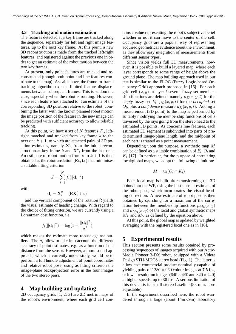
5 Experimental resultsThis section presents some results obtained by pro-cessing sequences of images acquired with our Activ-Media Pioneer 3-DX robot, equipped with a VidereDesign STH-MDCS stereo head (Fig. 1). The latter isa low-cost commercial product nominally capable ofyielding pairs of1280× 960 colour images at7.5 fps,or lower resolution images (640×480 and320×240)at higher speeds, up to 30 fps. A serious limitation ofthis device is its small stereo baseline (88 mm, non-adjustable).
In the experiment described here, the robot wan-dered through a large (about 14m×9m) laboratory
Proceedings of the 5th WSEAS Int. Conf. on Signal Processing, Computational Geometry & Artificial Vision, Malta, September 15-17, 2005 (pp176-181)
room with several desks and various instruments (seeFigs. 2 and 3). Along its trajectory (about 60m to-tal), the robot stopped for looking around either af-ter covering a path length of 1 m, or after a headingchange of 45◦. About 7000 stereo pairs were acquiredat640× 480 resolution.
Fig. 4a shows the final global map built using forthe robot pose the raw odometric data, without apply-ing the correction proposed above. Comparing the lat-ter with the CAD model of the environment shown inFig. 2, it is evident that the odometric trajectory accu-mulates a rather large heading error (about 20◦). Ascan be seen in Fig. 4b, not much is gained by correct-ing only the translation estimate by map correlation.
By contrast, Fig. 5a shows the result of the pro-posed approach. Fig. 5b shows that the result is notsignificantly improved by performing also an angularsearch for best correlation around the visual headingestimate. Fig. 6 shows the cumulative heading cor-rection for the two latter cases, i.e. with and withoutangular search.
It must be remarked that all correlation computa-tions are done with the robot stopped, while the vi-sual heading algorithm runs during the robot’s move-ment. Therefore, eliminating the need for angular cor-relation search in the registration step greatly reducesdead times.
Figure 1: The mobile robot with stereo head.
6 Concluding remarksIn this work we have considered the problem of reduc-ing the accumulated pose error in a grid-based SLAMsystem using a stereo vision sensor. It has been shownthat periodically estimating the heading change by vi-sion it is possible to recover most of the heading errorwith respect to dead reckoning, while 2D positionalerror can be efficiently recovered by map correlation.Further work on this topic is needed, particularly for
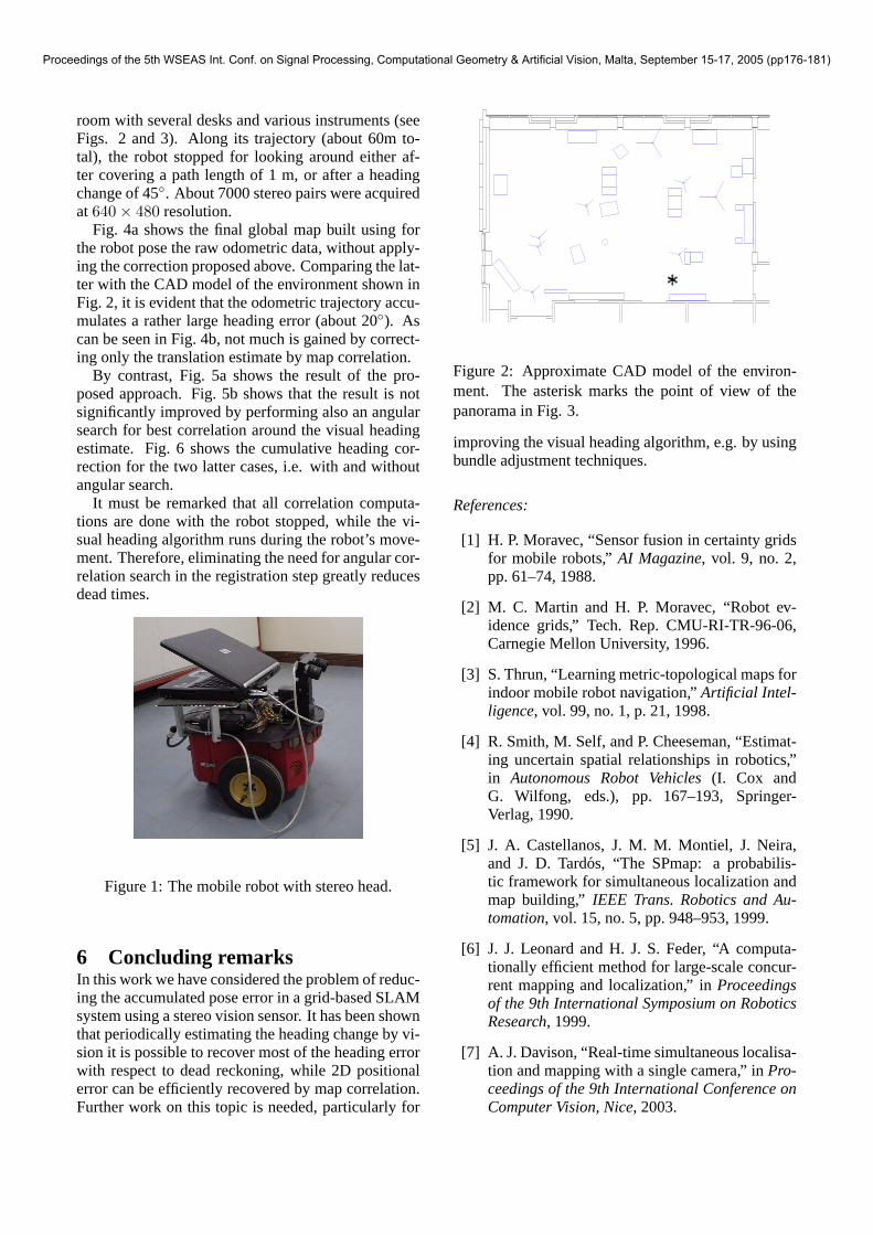
Figure 2: Approximate CAD model of the environ-ment. The asterisk marks the point of view of thepanorama in Fig. 3.
improving the visual heading algorithm, e.g. by usingbundle adjustment techniques.
References:
[1] H. P. Moravec, “Sensor fusion in certainty gridsfor mobile robots,”AI Magazine, vol. 9, no. 2,pp. 61–74, 1988.
[2] M. C. Martin and H. P. Moravec, “Robot ev-idence grids,” Tech. Rep. CMU-RI-TR-96-06,Carnegie Mellon University, 1996.
[3] S. Thrun, “Learning metric-topological maps forindoor mobile robot navigation,”Artificial Intel-ligence, vol. 99, no. 1, p. 21, 1998.
[4] R. Smith, M. Self, and P. Cheeseman, “Estimat-ing uncertain spatial relationships in robotics,”in Autonomous Robot Vehicles(I. Cox andG. Wilfong, eds.), pp. 167–193, Springer-Verlag, 1990.
[5] J. A. Castellanos, J. M. M. Montiel, J. Neira,and J. D. Tard́os, “The SPmap: a probabilis-tic framework for simultaneous localization andmap building,” IEEE Trans. Robotics and Au-tomation, vol. 15, no. 5, pp. 948–953, 1999.
[6] J. J. Leonard and H. J. S. Feder, “A computa-tionally efficient method for large-scale concur-rent mapping and localization,” inProceedingsof the 9th International Symposium on RoboticsResearch, 1999.
[7] A. J. Davison, “Real-time simultaneous localisa-tion and mapping with a single camera,” inPro-ceedings of the 9th International Conference onComputer Vision, Nice, 2003.
Proceedings of the 5th WSEAS Int. Conf. on Signal Processing, Computational Geometry & Artificial Vision, Malta, September 15-17, 2005 (pp176-181)
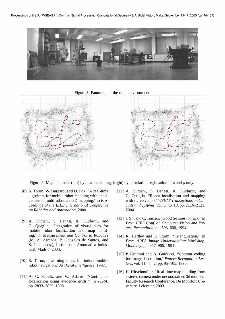
Figure 3: Panorama of the robot environment.
Figure 4: Map obtained: (left) by dead reckoning, (right) by correlation registration inx andy only.
[8] S. Thrun, W. Burgard, and D. Fox, “A real-timealgorithm for mobile robot mapping with appli-cations to multi-robot and 3D mapping,” inPro-ceedings of the IEEE International Conferenceon Robotics and Automation, 2000.
[9] A. Cumani, S. Denasi, A. Guiducci, andG. Quaglia, “Integration of visual cues formobile robot localization and map build-ing,” in Measurement and Control in Robotics(M. A. Armada, P. Gonzales de Santos, andS. Tachi, eds.), Instituto de Automatica Indus-trial, Madrid, 2003.
[10] S. Thrun, “Learning maps for indoor mobilerobot navigation,”Artificial Intelligence, 1997.
[11] A. C. Schultz and W. Adams, “Continuouslocalization using evidence grids.,” inICRA,pp. 2833–2839, 1998.
[12] A. Cumani, S. Denasi, A. Guiducci, andG. Quaglia, “Robot localisation and mappingwith stereo vision,”WSEAS Transactions on Cir-cuits and Systems, vol. 3, no. 10, pp. 2116–2121,2004.
[13] J. Shi and C. Tomasi, “Good features to track,” inProc. IEEE Conf. on Computer Vision and Pat-tern Recognition, pp. 593–600, 1994.
[14] R. Hartley and P. Sturm, “Triangulation,” inProc. ARPA Image Understanding Workshop,Monterey, pp. 957–966, 1994.
[15] P. Grattoni and A. Guiducci, “Contour codingfor image description,”Pattern Recognition Let-ters, vol. 11, no. 2, pp. 95–105, 1990.
[16] H. Hirschmuller, “Real-time map building froma stereo camera under unconstrained 3d motion,”Faculty Research Conference, De Montfort Uni-versity, Leicester, 2003.
Proceedings of the 5th WSEAS Int. Conf. on Signal Processing, Computational Geometry & Artificial Vision, Malta, September 15-17, 2005 (pp176-181)
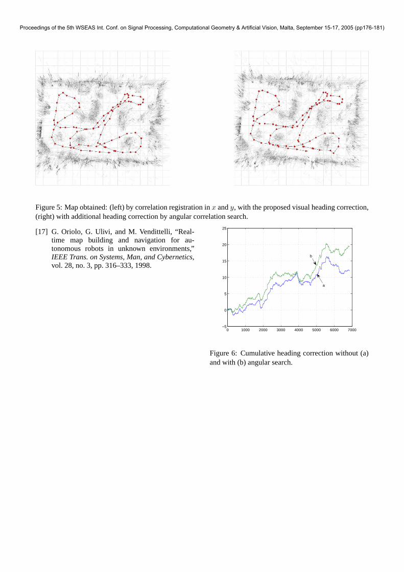
Figure 5: Map obtained: (left) by correlation registration inx andy, with the proposed visual heading correction,(right) with additional heading correction by angular correlation search.
[17] G. Oriolo, G. Ulivi, and M. Vendittelli, “Real-time map building and navigation for au-tonomous robots in unknown environments,”IEEE Trans. on Systems, Man, and Cybernetics,vol. 28, no. 3, pp. 316–333, 1998.
0 1000 2000 3000 4000 5000 6000 7000−5
0
5
10
15
20
25
a
b
Figure 6: Cumulative heading correction without (a)and with (b) angular search.
Proceedings of the 5th WSEAS Int. Conf. on Signal Processing, Computational Geometry & Artificial Vision, Malta, September 15-17, 2005 (pp176-181)