evolution of the brazilian phytogeography classification
TRANSCRIPT

Ciência e Cultura 51(5/6): 331-348, 1999.
Evolution of the Brazilian phytogeography classification
systems: implications for biodiversity conservation.
JOLY, C.A.1; AIDAR, M.P.M.2;KLINK, C.A.3; McGRATH, D.G.4,5; MOREIRA, A. G.6; MOUTINHO, P.5; NEPSTAD, D.C.5,7; OLIVEIRA, A. A.8; POTT, A.9; RODAL, M.J.N.10 & SAMPAIO, E.V.S.B.11
1 Depto. Botânica, IB, UNICAMP, CP 6109, 13083-970, Campinas, SP (mailto:[email protected])
2 Seção de Fisiologia e Bioquímica de Plantas, Instituto de Botânica, CP 4005, 01061-970, São Paulo, SP ([email protected])([email protected])
3 Depto. de Ecologia, Universidade de Brasilia, C.P. 04631, 70919-970, Brasilia, DF. ([email protected])
4 Núcleo de Altos Estudos Amazônicos, UFPa, Campus Guamá, 66075-970, Belém, PA.
5 Instituto de Pesquisa Ambiental da Amazônia, Trav. Enéias Pinheiro, 1426, Marco, 66095-100 Belém, PA. ([email protected])([email protected])
6The Woods Hole Research Center &Instituto de Pesquisa Ambiental da Amazônia, SCLN 210, bloco C, sala 209, 70865-530, Brasilia, DF ([email protected])
7The Woods Hole Research Center, Woods Hole, MA 02543, USA.
8Universidade de São Paulo, USP, Instituto de Biociências, Ecologia. Rua Matão 321, trav. 14.05008-900. São Paulo, SP.
9Centro de Pesquisa Agropecuária do Pantanal, EMBRAPA, R. 21 de Setembro, 1880 , 79.320-900, Corumbá, MS (mailto:[email protected])
10Departamento de Energia Nuclear, UFPE, Av. Prof. Luís Freire 1000, 50740-540, Recife, PE ([email protected])
11Departamento de Biologia, UFRPE, R. Dom Manoel de Medeiros s/n, 52.171-900, Recife, PE
[email protected]) ([email protected])
Summary
Undoubtedly the increase in scientific knowledge and the use of techniques such as remote sensing fostered a significant evolution of Brazilian phytogeography. Today there is a much better knowledge of the distinct physiognomies present in our territory. In some areas, such as the Caatinga and the Campos Sulinos, there is an urgent need of more detailed

information on the floristic composition and structure of the distinct types of vegetation to allow a better phytogeographic classification. From the biodiversity conservation approach it is important to consider not only the present types of physiognomies. It is imperative to take the evolutionary process in account and, on doing that, one can not avoid concluding that conservation policies must be established at the biome level.
Resumo
Indiscutivelmente, o aumento no conhecimento científico e o uso de técnicas como o sensoreamento remoto permitiram uma grande evolução da fitogeografia brasileira, principalmente nas últimas décadas. Temos hoje um conhecimento muito mais detalhado das distintas fisionomias vegetais presentes no território brasileiro. Infelizmente, o conhecimento existente não é homogêneo. No caso da Caatinga e dos Campos Sulinos, por exemplo, a base de informações existentes sobre a composição florística e sobre a estrutura dos diferentes tipos de fisionomia presentes nestes complexos, é insuficiente para estabelecermos uma classificação fitogeográfica mais precisa. Do ponto de vista da conservação da biodiversidade é importante não nos atermos às fisionomias atuais, pois para compreendermos as atuais formações é imprescindível considerarmos o processo evolutivo como um todo. Concluímos, portanto, que as políticas de conservação devem ser estabelecidas a nível de bioma.
Introduction
There is no doubt that the present distribution of species, ecosystems and biomes started to be shaped more the 180 million years ago, when the super-continent Pangea started to brake and, due to continental drift, the land masses started to be shaped and move towards the format and place they occupy today (1). The history of the present landscape of Brazil had its turning point with the fragmentation of the Gondwana continent and South America started to drift away from Africa after a rotational movement that reached an angular value of approximately 40o before drifting in an East-West direction (2). According to Veloso & Goes Filho (3) the present distribution of the Neotropical flora of Brazil is the result of geomorphological processes, such as the development of the major hydrographic basins, cutting through the Pre-Cambrian crystalline basement shield of Brazil, and the subsequent deposition of sedimentary basins. These processes were significantly affected by the climatic changes of the last 40 million years. In Brazil the effects of these dramatic climatic changes in species distribution and evolution, as well as the retraction and expansion of biomes such as tropical forests and savanna, is well recorded only for the Quaternary period, the last 2 million years. Glacial periods in the northern hemisphere, with a significant drop in Earth’s temperature,

affected the distribution of air masses and the wind system. Cooler oceans and lower temperatures reduced evaporation, consequently in the southern hemisphere the humid tropical and sub-tropical climates gave place to cooler arid and semi-arid ones. In the inter-glacial periods evaporation was higher, due to warmer seas and temperatures, the water cycle ocean/continent was more active, increasing rainfall and bringing humidity also to inland areas (4). During the last glacial period (Wisconsin-Würm Glaciation), that started between 60 and 70.000 BP, reaching its peak approximately at 18.000 BP, average temperature was 5oC lower then today, sea level was approximately 100 m lower and rainfall was seasonal and typical of arid and semi-arid climates. As a consequence, in Brazil, tropical rain forest, both from the Amazon region and from the Atlantic region, were reduced to the Pleistocene refuge areas, where humidity conditions could maintain them (4); savanna and steppe areas covered most part of the Brazilian territory; the Araucaria forest reached the southern areas of Bahia State (5); and the coastal plains were approximately 180 km wider then today (6). The inter-glacial period that we live today started only 14.000 years ago when the glaciers of the northern hemisphere started to retrieve, triggering a more humid climate that lead to a maximum of tropical rain forest expansion, covering, for example, large areas of the Brazilian northeast. After this climatic optimum the forest retrieved and the semi-arid vegetation expanded to its present area of occurrence.
I – A summary of the evolution of the phytogeographic classification systems of Brazil The systems used to classify vegetation can be divided in two major groups: those that use physiognomic-environmental parameters and characteristics and those that are based on floristic relationships. Since the discovery of the New World by Spanish and Portuguese sailors there have been attempts to classify and describe the new types of plants and animals they found. However it was only in the beginning of the last century that phytogeography started its development as a branch of science. We can consider the publication of Alexander F. von Humboldt (7) on physical geography as the first paper on phytogeography, and therefore regard him as the father of this branch of science. Later on, in 1872, Grisebach (8) used physiognomic characters to group plants, dividing plant communities in forests, fields, etc... In 1889 Drude (9) proposed the division of the Earth in zones, areas, domains and section based on plant communities distribution. The first attempt of classifying Brazilian vegetation was published by Martius, the author of the "Flora Brasiliensis", in 1824 (10). He divided the country in five floristic domains, named after four immortal and one mortal Greek nymphs: Nayades (Amazonian) the nymph of the waters; Oreades the nymph of the hunting fields (Cerrados, the savanna of central Brazil; Dryades, the nymph of the forests (Mata Atlântica, the Atlantic Rain Forest); and Napeias (Mata de Araucaria & Campos Sulinos, Araucaria forest and the southern grasslands) the nymph of the ravines; Hamadryades, a nymph that dies and resurrects, was used to name the vegetation of the semi-arid Northeast (Caatinga) that resurrects every
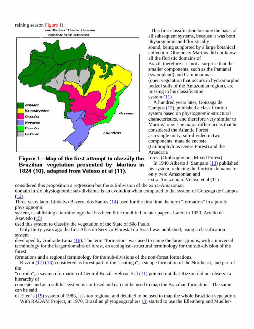
raining season Figure 1) This first classification became the basis of all subsequent systems, because it was both physiognomic and floristically sound, being supported by a large botanical collection. Obviously Martius did not know all the floristic domains of Brazil, therefore it is not a surprise that the smaller components, such as the Pantanal (swampland) and Campinaranas (open vegetation that occurs in hydromorphic podzol soils of the Amazonian region), are missing in his classification system (11). A hundred years later, Gonzaga de Campos (12), published a classification system based on physiognomic-structural characteristics, and therefore very similar to Martius’ one. The major difference is that he considered the Atlantic Forest as a single unity, sub-divided in two components: mata de encosta (Ombrophylous Dense Forest) and the Araucaria forest (Ombrophylous Mixed Forest). In 1940 Alberto J. Sampaio (13) published his system, reducing the floristic domains to only two: Amazonian and extra-Amazonian. Veloso et al (11)
considered this proposition a regression but the sub-division of the extra-Amazonian domain in six physiognomic sub-divisions is an evolution when compared to the system of Gonzaga de Campos (12). Three years later, Lindalvo Bezerra dos Santos (14) used for the first time the term "formation" in a purely physiognomic system, establishing a terminology that has been little modified in later papers. Later, in 1950, Aroldo de Azevedo (15) used this system to classify the vegetation of the State of São Paulo. Only thirty years ago the first Atlas do Serviço Florestal do Brasil was published, using a classification system developed by Andrade-Lima (16). The term "formation" was used to name the larger groups, with a universal terminology for the larger domains of forest, an ecological-structural terminology for the sub-division of the forest formations and a regional terminology for the sub-divisions of the non-forest formations. Rizzini (17) (18) considered as forest part of the "caatinga", a steppe formation of the Northeast, and part of the "cerrado", a savanna formation of Central Brazil. Veloso et al (11) pointed out that Rizzini did not observe a hierarchy of concepts and as result his system is confused and can not be used to map the Brazilian formations. The same can be said of Eiten’s (19) system of 1983, it is too regional and detailed to be used to map the whole Brazilian vegetation. With RADAM Project, in 1970, Brazilian phytogeographers (3) started to use the Ellemberg and Mueller-

Dombois (20) system that was later on officially adopted by IBGE(11). Ellemberg & Mueller-Dumbois (20) is the most modern physiognomic-ecological phytogeographic system of world vegetation classification. It is based on the systems developed by Aubréville (21) and Trochain (22) (23) and UNESCO uses it as the standard system. It obeys a hierarchical system that is divided in classes, formations and sub-formations.
II. RADAMBRASIL - the official classification system of Brazilian vegetation The RADAMBRASIL Project, a follow up of the RADAM Project, published in 1982 (3) what later one became the standard reference (Classificação da Vegetação Brasileira adaptada a um sistema universal) of the present classification system of vegetation (Figure 2). With minor changes the system was used in the maps published by IBGE in 1988 and 1991 (11).
At the regional scale the system adopted by IBGE is based on physiognomic and ecological characteristics, as the system proposed by Drude in 1889 (9) but it uses the vegetation concepts developed by Schimper in 1903 (24) and the universal approach suggested by Ellemberg & Mueller-Dombois in 1966 (20) The major objectives of this classification systemwere: a.mapping - to allow the use of remote sensing to map and classify Brazilian vegetation;
b.establishing

floristic zones – each part of the Brazilian territory is occupied by a vegetation type characterized by one or more endemic genus; therefore the vegetation type can be considered an ecological zone due to the occurrence of life forms typical of the dominant climate;
c.establishing physiognomic-ecological concepts – the dominant physiognomic structure that is determined by the predominant life form - tree or herbaceous – is used to establish the ecological regions or distinct classes of vegetation. The sub-classes, on the other hand, are determined by climate (ombrophylous or seasonal, for example). At the formation group level, the divisions are based on physiological characteristics, such as hygrophytic and xerophytic, and soils parameters, such as dystrophic and eutrophic. The sub-group of formations is established by parameters like dense, open, mixed, deciduous, etc... and the formation is defined by characteristics such as with liana, with bamboo, uniform dossel or with emergent species, etc...
Specialists working in different phytogeographic regions of Brazil wrote the next sections. To maintain the original approaches, styles and points of view, each contribution was incorporated in the present article with only minor changes. Usually made to reduce the size of each part to fit into the space available for this article. Using the RADAMBRASIL classification system we can divide the Brazilian flora into four major biomes, as presented in Figure 3. The Amazon Forest (written by David G. McGrath, Paulo Moutinho, Daniel C. Nepstadand Alexandre A. de Oliveira), the Atlantic Forest (by Carlos A. Joly and Marcos P.M. Aidar), the
Savanna (by Carlos A. Klink and Adriana G. Moreira) – that comprises also the Brazilian swampland (Pantanal, written by Arnildo Pott) and the Steppe, that comprises both the semi-arid Northeast (Caatinga, by Everardo V. S. B. Sampaio and Maria Jesus N. Rodal) and the southern grasslands (Campos Sulinos, by Carlos A. Joly and Marcos P.M. Aidar).
PARADIGMS OF AMAZON FOREST ECOLOGY AND CLASSIFICATION
Beginning with the often imaginative accounts of the first explorers and adventurers to travel through the region in the 16th century, the seemingly endless expanse of Amazon forests fascinated the outside world (25) (26). Formal investigation of the Amazon rainforest began with the scientific expeditions of the 18th and especially 19th centuries (27) (28). As research on Amazonian forests has progressed over the past two hundred years, scientific conceptions of the ecology and phytosociology of the Amazon forest have undergone major transformations, with profound

implications for our understanding of the potential of Amazonian forest ecosystems for human exploitation, and the environmental consequences of such intervention on local, regional and global scales.
Early ecological conceptions The early scientific explorers to the Amazon were struck by the exuberance of the vegetation and the diversity of life forms, compared to that of Europe (27). The huge forest trees and dense vegetation, vast numbers of species and rapid regrowth of vegetation in abandoned clearings were all taken as evidence of the fertility of the soils and, consequently, of the great agricultural potential of the region (27). As Wallace (28) observed of the Rio Negro basin, a region now noted for the poverty of its soils: "For richness of vegetable production and universal fertility of soil, it is unequalled on the globe . . . ." . In Martiu’s first attempt to classify the vegetation of Brazil, he classified the forests of Amazon as different than other major biomes, but internally homogenous. For these scientists, there was no great mystery in explaining the richness of Amazonian forests. The exuberant vegetation of the Amazon could be explained by the year round abundance of solar energy, high humidity and fertile soils, ideal conditions for plant growth and life in general. Their experience in temperate forests, where tree size is a good indicator of soil fertility, may have reinforced this interpretation (29). The weak performance of local farmers was not due to poor soils, but to the ferocious competition of native plants and animals (28).
The Illusion of Abundance As evidence from ecological fieldwork in the Amazon accumulated in the middle of the 20th century, the scientific community was surprised to discover that the massive, lush forests of the region grew on acid-infertile soil. Two phases in the development of this new interpretation of Amazon forests can be identified, one based on an ecosystem approach and a later variant derived from evolutionary ecology. The Rainforest as a Closed System. The "illusion of abundance" in Amazon forests was explained primarily on the basis of field studies conducted in the Upper Rio Negro basin of Venezuela by C. Jordan and colleagues (30) and the studies of P. Richards conducted in the old world tropics (31). The point of departure for the development of this model was the extremely low fertility of terra firme soils. Many of the soils of Amazon are highly infertile, depleted of mineral nutrients by millions of years of weathering under warm, moist conditions and, according to the early accounts, hardened into rock-like plinthite upon exposure to the equatorial sun (32). In this model, the soil is a sterile substrate and virtually all nutrients are assumed to be contained in the forest biomass (29). If the forest is removed, the soil does not contain sufficient nutrients to support the regeneration of the original vegetation (32). The basic problem faced by tropical forest species in this model is nutrient retention: how to minimize loss of nutrients from the system and how to maximize the absorption of nutrients from external sources such as rainwater. To minimize nutrient losses, plants and soil microorganisms developed symbiotic relationships in which nutrients released from decomposing organic material by the action of fungi and bacteria are transferred directly to the roots of forest plants via

the action of mycorrhizal fungi (33) (34). Tropical forest trees were assumed to be shallow rooted, concentrating virtually all their root biomass in the litter layer and upper 50 to 100 centimeters of soil, the zone in which the release of mineral nutrients through decomposition of organic material takes place. The scarcity of nutrients in forest soils and the need to minimize losses from the system had significant implications for species interaction and the life strategies of tropical forest species. One characteristic of tropical forest plants, for example, is the abundance of alkaloids and other toxins in plant tissues, which was interpreted as a strategy for minimizing predation and the loss of precious nutrients. One consequence of the toxicity of tropical forest plants was that herbivores tended to be highly specialized due to the cost of developing mechanisms for detoxifying plant poisons (35). Another, was the relative scarcity of animals in tropical forests (31). Given the lack of nutrients in the soil, rainwater was considered to be the major source of nutrients into the system, and a number of features of tropical forest plants were interpreted as mechanisms for conserving nutrients. Drip tips on leaves reduced the residence time of rainwater on leaf surfaces, minimizing the loss of leaf nutrients, while lichens on leaves surfaces and epiphytes in general filter nutrients out of rainwater incorporating them into the forest ecosystem.
Niche Specialization and Co-Evolution. With the development of evolutionary ecology in the 1970’s and ‘80’s, the low nutrient model of the tropical forest underwent further refinement, while retaining earlier assumptions regarding soil fertility. In this version, the focus is on the high species diversity of the tropical forest and on mechanisms for maintaining such diversity. Emphasis shifted from explaining the aggregate functioning of the forest’s species, to explaining the evolutionary functionality of the complex adaptations of forest species and the intricate interactions between species. Here the point of departure was the assumption of the extreme age and overall stability of the tropical forest biome through time. Through a process of intense competition under largely stable environmental conditions, species developed highly specialized strategies to exploit ever-narrower niches (36). At the same time, through a process of co-evolution, highly specific mutualisms developed among forest species. The result is a highly diverse and complex community in which each species plays a distinct and significant role in the overall functioning of the forest ecosystem. This view was linked to earlier conceptions of the relationship between ecosystem resilience and species diversity, and the assumption that the efficiency of ecosystems in transforming solar energy and nutrients into biomass is also related to species diversity.
Deep Root Model Over the last twenty years, several key elements of the "illusion of abundance" model of Amazon ecology have been challenged, resulting in a new configuration of the relationship between soil fertility, species diversity and

forest biomass. New elements have been introduced, especially the role of forests in hydrological and climatological processes that were ignored in the earlier model. The main point of departure in the development of this new model is, once again, the nature of Amazonian soils. Over the last two decades, the original view of Amazonian soils as uniformly infertile and fragile has been replaced with a much more detailed and sophisticated understanding of the diversity of Amazonian soils in terms of physical characteristics and fertility. In an early paper, Sanchez (37) (38) argues that, contrary to the prevailing view, Amazonian soils have good structure and variable fertility, and are in many respects little different from the Oxisol soils (latosolos) of the southeastern U.S. Furthermore, only about 7% of the region’s soils are potentially vulnerable to laterization upon clearing (39). While there are problems from an agronomic standpoint, they are far from insurmountable. Other researchers have questioned the conclusion that forest regeneration is limited by low soil fertility, finding no correlation between soil fertility and rates of forest regrowth following land abandonment (40). Perhaps the most important challenge to the "illusion of abundance" view of Amazon forests is the discovery that the roots of many forest species extend far deeper into the soil than originally thought. Studies by Nepstad and colleagues (41) and other groups (42) have shown that as much as 15% of total root biomass is below a depth of one meter, and that at least 8 to 12 meters of soil are fully integrated into the forest ecosystem. This large volume of soil supplies two key resources to the forest ecosystem, water and nutrients. Approximately 40% of Amazon forests depend upon the absorption of soil water stored to depths of several meters to maintain their leaf canopies during severe seasonal drought. These deeply rooting forests release large amounts of water vapor into the atmosphere during the dry season, when shallow-rooted vegetation becomes dormant. This water vapor helps to form the clouds that produce rain downwind (43). This remarkable ability of Amazon forest trees to avoid drought-induced leaf shedding also explains their resistance to fire. The evergreen leaf canopy allows these forests to maintain the deep, moist shade of the forest interior, such that the forest floor is difficult to ignite (44) (45). In the absence of deeply rooting forests, much of eastern Amazon might support savanna instead of dense forest, and the entire region might receive less rainfall. The ability of these forests to absorb moisture stored deeply in the soil prevents them from being displaced by savanna. Deeply rooting trees also absorb mineral nutrients that are available in this large volume of soil. In fact, the mycorrhizal fungi that assist roots in the acquisition of phosphorus and other scarce rainforest nutrients (42) have now been found in roots extending to 9 meters soil depth (46). Even if soils are of low fertility, the absolute quantity of nutrients available in this large volume of soil constitutes a significant pool that was previously assumed to be outside of the forest ecosystem. In the deep root model , then, the key process is no longer nutrient cycling in the upper meter of the soil, but hydrological processes incorporating 12 to 18 times this volume of soil into the forest ecosystem. Other elements of the model are also being questioned, especially those relating to the functional significance of the high species diversity of tropical forests, and the assumption of environmental stability over long periods of time. Over thelast two decades, a series of theoretical and empirical studies of the relationship between ecosystem stability and diversity have produced contradictory results. However, several recent studies reviewed by Grime (47), indicate that the relationship between stability and diversity is weak at best (48) (49) (50). Corroborating evidence has emerged from a long-term study of a 50-hectare plot on Barro Colorado Island, where researchers have been unable to find evidence of high levels of niche specialization among tree species (51). These studies demonstrate that it is functional

diversity, that is, the number of plant functional groups represented, and not the number of species per se which is the critical element of ecosystem resilience. The view of the Amazon forest that is emerging from these and related studies is of a far more dynamic, complex and resilient ecosystem than assumed in the original tropical forest model. Whereas in the past the key element was soil fertility, in the new version it is the climate and hydrological (40). Drawing on water and nutrients stored in a volume of soil up to 18 times that in the original model, tropical forests are far more resilient than originally supposed in their ability to withstand extended periods of drought and to regenerate following even major disturbances (43). Furthermore, the earlier mechanistic model of the forest as the product of millions of years of evolution, during which species co-evolved to produce a complicated and highly efficient machine, is giving way to a new view of the tropical forest as a complex and chaotic system, the result of almost constant environmental change on a range of spatial and temporal scales (52)(53).
Floristic View of the Forest According to Sampaio (54), after von Martius’s map (10), the first division of Amazonian forests was made in 1908 by Ule, who recognized two major forest formations north and south of the Solimões and Amazon rivers. But it was only in 1953 that the remarkable regional heterogeneity and floristic diversity of Amazon began to be formally classified. A. Ducke and G. A. Black (55) conducted the first phytogeographical study of Amazonian forests, defining phytogeographical forest types on the base of species endemism, physiognomy, plant distribution, soil type and topography. Their interpretation divided the Amazon forest into Atlantic, Northeastern, Southeastern, Northern, Southern, and Sub-Andean types. Other authors proposed similar phytogeographical divisions (56), (57) (58). In recent decades, G. T. Prance employed five common and broadly distributed plant families to re-interpret Amazon phytogeography (Chrysobalanaceae, Caryocaraceae, Dichapetalaceae, Connaraceae e Lecythidaceae). He identified 8 distribution patterns and 7 phytogeographical regions in Amazon, including: Atlantic Coast, Jari-Trombetas, Xingú-Madeira, Roraima-Manaus, Upper Rio Negro, Western Solimões-Amazonas e Southeast (59) (60). More recently, Prance further refined his phytogeographical analysis to on the basis of endemism patterns, sub-dividing Amazon into four principal sub-regions (Northeast, Central North, Southeast, and Central South). Amazonian classification took another large step from 1973 to 1981, through the RADAMBRASIL project. Radar images were employed to map topography, elevation, soil, vegetation, and land-use activities. This image analysis was supplemented by extensive field campaigns to identify the major vegetation types using criteria such as forest size, forest
density, and degree of leaf shedding. The resulting vegetation classification system (11) allows for the identification of many vegetation types using satellite imagery, which is a tremendous advance for a region as vast as Amazon is. A total of 21 phytophysiognomies have been identified using images from RADAMBRASIL (11) (61).
Implications for Amazonian Development and Conservation The changing perception of the structure and function of Amazon forests has had significant implications for our understanding of the ways in which human activities in the basin affect this ecosystem. In the original version of the "illusion of abundance" model, in which low soil fertility was considered to be the critical factor, it was thought that once the forest was removed, it would not regenerate, and the "green hell" would give way to a "red desert" (32). In the "niche specialization" version of the model concern shifted to the possibility of massive species extinction resulting from forest clearing and degradation (50) (51). In more extreme versions even minor extractive activities such as subsistence hunting and collection of non-timber forest products are regarded as antiethical to the preservation of the forest ecosystem, since loss of even a few species would impair its functional integrity (62) (63). In this model the emphasis has been on preservation of pristine forests with little concern for the fate of areas which have already been cleared or logged since they are considered to be of little value for preserving biological diversity (56). On a regional scale, the basis for this approach has been the refugia theory initially developed by Haffer (52) and the "hot spots" approach to biodiversity conservation proposed by Myers (64). Thus, efforts have focussed on preserving forests in areas of high species diversity and endemism such as the mountainous regions of the western Amazon, although areas elsewhere in the basin considered to be centers of endemism are also regarded as important. The deep root model of tropical forests (40) leads to a very different view of the environmental impacts of Amazonian development. Here the key factor is the role of the forest hydrological cycle on local and regional scales. Studies have demonstrated that the Amazon forest plays a critical role in the regional hydrological cycle (65), and that through evapotranspiration up to 40% of Amazon precipitation is recycled by the forest (66). The ability of forest roots to tap water stored deep in the soil during the dry season is critical to the maintenance of evergreen forest on a regional scale. In this model the main threat to the forest is not so much clearing but accidental fires. One of the main challenges facing vegetation scientists working in Amazon today is to understand the functional significance of the large number of phytophysiognomic vegetation types identified in Amazon. Under the biodiversity conservation point of view one must consider, simultaneously, the conservation of all physiognomies and policies to ensure the conservation of the biome as a whole, as established in the recent workshop "Avaliação e identificação de ações prioritárias para a conservação, utilização sustentável e repartição dos

benefícios da biodiversidade da amazônia brasileira (http://www.socioambiental.org/bio)".
ATLANTIC RAIN FOREST– WHY IT IS SO DIFFICULT TO ESTABLISH ITS BOUNDARIES ?
The Atlantic rain forest is the domain that shows the largest variation in extension when we compare the phytogeographic division presented by Martius (10)(Figure 1) and the actual map of biomes (67) (Figure 3). The definition of the limits of this biome is polemic and has been at the center of a long-standing academic controversy. The Brazilian craton, composed mainly by crystalline rocks (granites and gneisses), has been above sea level since the Pre-Cambrian. Therefore it is considered the center of origin and dispersion of the forest flora that occurs from the Brazilian northeast, Cabo de São Roque at 5o S in the State of Rio Grande do Norte, to the Taquari river at 30o S, in the state of Rio Grande do Sul. The geomorphological and climatic characteristics of the region between Guarapari (ES) and Cabo Frio (RJ), where the forest is replaced by a xerophytic vegetation, are the determinants of the unique natural interruption of the long strip of tropical rain forest, that has variable width and comprises many physiognomies of forests that have in common their origin and evolution (68) Along the coastal region, sea level variations, which reached more then 100 meters in amplitude, had a considerable impact in the development of the coastal plains. The coastal line changed dramatically along the late Tertiary Period and the Pleistocene. In some areas the coastal, plains were up to 180 km wider during the drier period and, at the peak of the humid period, areas that are today above sea level were submerse. The shape and position of estuaries, rivers and lagoons as well as the mosaic of vegetation types, dunes, mangroves and "restinga" (sandy plains scrub and forest) were strongly influenced by these fluctuations of the sea level (68) The forest physiognomy of the restinga, that has a great number of epiphyte species, suffered also the influence of the expansions and retractions of the Ombrophylous Dense Forest of the slopes of the Serra do Mar. Therefore plant diversity in the coastal plain forest – slope forest ecotone is extremely high (69). The rate of destruction of these vegetation types, classified as ecosystems of fluvial-marine influence in the IBGE map, is still very high. Mangroves are being transformed in small harbors and marines for boats and jet skies, the "restinga" is being replaced by big vacation condominiums and sand dunes are being destroyed by bars and other facilities for the thousands of tourists that visit these areas every year. Considering their geographical position and their evolutionary history, there is no doubt that, under the conservation point of view, these vegetation types must be considered and protected as part of the Atlantic domain. The academic debate about the geographical limits of the Atlantic Rain Forest (Mata Atlântica) has immediate consequences for conservation. Some authors like Ferri (70) and Leitão Filho (71) considered Mata Atlântica only the ombrophylous dense forest that is under the direct influence of the orographic rainfall, while others (72) (73)

suggest that the semi-deciduous and deciduous forest on the interior of the States of Minas Gerais and São Paulo should also be included under the same name. A third group of authors (74) claim that the ombrophylous mixed forest, where the physiognomie is given by Araucaria angustifolia trees, should also be considered as Mata Atlântica because all these physiognomies of forest, ombrophylous dense, ombrophylous open, ombrophylous mixed, semi-deciduous and deciduous had a common origin. Moreover, during the Quaternary period the alternated humid tropical and subtropical climates with arid and semiarid ones had as a consequence expansions and reductions of these forest facies, with a strong influence in species distribution and speciation processes of flora and fauna (5). The controversy stimulated floristic survey projects, which had a significant impact on the knowledge of species richness as well as species distribution. Analyzing this inventories Oliveira-Filho & Fontes (73) investigated the tree flora of southeastern Brazilian Atlantic forests in respect to the variations in floristic composition of both rain and semi-deciduous forests in the light of geographic and climatic variables and their links with Amazonian forests and Cerrados. The authors reached the following conclusions: a) the tree flora of semi-deciduous forests is a sub-set of the rain forests' flora, probably including species that are able to cope with a longer dry season; b) there is greater floristic similarity at the species level between Atlantic Rain Forest and Semi-deciduous Forests than between any of these and either Amazonian Rain Forest and Cerrados. The authors also included two areas of Araucaria Forest, which analysis of correspondence with geo-climatic variables produced an output close to Upper Montane Rain Forest, indicating higher association with temperature range than altitude. This result is coincident with results cited by Gentry (75) for Andean and Central America Forests. In addition, many genera strongly correlated with high altitudes in southeast Brazil are considered diagnostic of Neotropical Cloud Forests by Webster (76). Palinological records from central and southeast Brazil prove that the climatic changes of the Pleistocene had a strong impact in the distribution of the forest physiognomies, as well as on species composition and distribution. The interpenetrating distinct forest types explains why in the present time we can find remnants of, for example, Araucaria forest in higher and cooler spots of areas covered by semi-deciduous forests (77). At the beginning of the Holocene, 10.000 to 7.000 BP, when the climate was still very dry and cold, Poaceae and Asteraceae still dominated areas that are today occupied by Araucaria forest that expanded during the cold but already humid period of 4.000 BP (78). In areas like Campos de Jordão, São Paulo State, the Araucaria forest is very recent, having replaced the herbaceous vegetation typical of the cold and dry climate only 2.500 years BP (79) (80). Oliveira Filho & Fontes (73) suggest that "the most correct approach to rain and semideciduous forests in southeastern

Brazil is that of a continuum of tree species distribution". Therefore, they claim that the definition of the Atlantic forest should be as comprehensive as that of the Amazon forest, in order to encompass all forest physiognomies occurring east of the dry corridor in northeast Brazil, and east from Paraguay and northeast from Argentina in southeast and south Brazil. We support that point of view because today there is enough evidence to understand that all these different physiognomies of vegetation ( Ombrophylous dense, Ombrophylous Open, Ombrophylous Mixed, Semi-deciduous and Deciduous Forests, as well as mangroves, restinga, dunes, estuaries, lagoons and high altitude rocky fields) present in the Atlantic Rain Forest Domain (Figure 3) must be considered as Mata Atlântica sensu lato. During the evolutionary process, there was an intense exchange of species and genes that gave origin to a complex of ecosystems, which are closely related and must be preserved as a unity, otherwise all the physiognomies will disappear with time. The Brazilian Atlantic Forest in its broader sense is considered one of the three most threatened ecosystems on Earth. When the Portuguese arrived in Brazil, five centuries ago, the forest covered more then 1.1 million Km2, but today this area has been reduced to approximately 8% of the original cover (81), most of it in steep slopes of the Serra do Mar in the southeast region. Although the high floristic diversity of the Brazilian Atlantic Forest has been recently questioned by Tabarelli and Mantovani (82) this megadiverse biome is classified among the top five ecosystems of the world in number of species and, therefore, considered a hotspot of biodiversity (64; 83). Nevertheless, all the forest types that belong to this biome are still being destroyed by uncontrolled logging, forest clearance for agriculture or pasture, mining and charcoal production. In our opinion, the Atlantic Domain must be seen as a single organism, with different organs playing complementary roles. The destruction of any of these organs will lead to the desappearence of the whole organism. Conservation measures can not be punctual, to be effective they must consider the variety of physiognomies and ecosystems as recently defined in the workshop Avaliação e Ações Prioritárias para Conservação dos Biomas Floresta Atlântica e Campos Sulinos (http://www.conservation.org.br/ma/index.html).
THE "CERRADO" AS A DISTIINCT BRAZILIAN ECOSYSTEM
Until last century the Brazilian central plateau vegetation used to be called "tabuleiros" and those types of vegetation with a well developed herbaceous strata scattered with trees were called "tabuleiros cerrados" (84). Already in the second half of the 19th century, "tabuleiros" have been replaced by the word "campos" (open field), and these vegetation types started to be called "campo limpo" (grassland), "campo sujo" (shrub savanna), and "campo cerrado" (wooded savanna) (84). More recently the word "Cerrado" has been used as a general term to designate this Brazilian region and its characteristic vegetation. When referring to the Cerrado ecologists have two concepts in mind: the physiognomic and the floristic one. In physiognomic terms the Cerrado shows a variety of vegetation types going from open grasslands to closed woodlands.

Floristically the Cerrado has a unique flora that distinguishes it from other Brazilian biomes, such as the Amazonian and coastal rain forests or the Northeastern dry land "caatinga". Coutinho (84) has proposed a broad concept for the Cerrado, which takes into account both the floristic and the physiognomic aspects of the vegetation. He considers the Cerrado as a gradient of savanna formations going from pure grasslands ("campo limpo") to forested formations ("cerradão"), that differ from each other by the relative abundance of woody and herbaceous (specially grasses) species. The Cerrado then is not homogeneous and its main aspect is its diversity. It has a high environmental diversity, in soil types, geology, geomorphology and climate where heterogeneous vegetation types can be found. Changes caused by fire, animal activity and more recently human interference are also important features of Cerrado. In this paper we describe the Cerrado as a diverse and distinct Brazilian ecosystem and propose that to understand, use and conserve the present and future Cerrado, a more integrated description of it has to be taken into consideration.
Soil and climate heterogeneity The Cerrado is located in the Brazilian Central plateau in the South American tectonic plate. The geology of the region is complex and shales are the predominant parent materials (85). Rocks are mostly from the Pre-Cambrian (from 4,700 to 570 million years ago) covered with laterites of the Cenozoic (approximately 65 million years ago). Red and yellow Latossols (Oxisols according to the American classification) and Sands cover 65% of the Cerrado the remainder consisting mostly of Alfisols, Ultisols, Entisols, and Inceptisols (86) (87). Most Cerrado soils are very deep and well drained, on gentle slopes, commonly less than 3%. Soil texture is variable but most of it is high in clay, which is dominated by kaolinite, gibbsite, and iron oxides (84), a mix of clay minerals and secondary minerals. About 89% of the Cerrado area corresponds to dystrophic soils (86), that are acidic, have low organic matter, low concentration of calcium, magnesium, phosphorus and potassium, high concentration of iron and aluminum, and the cation exchange capacity is low. (87) (88). The high aluminum concentration in the Cerrado soils is a matter of concern and argument. While high aluminum saturation in the cation exchange capacity of the soil can decrease crop productivity (88), some native trees are able to accumulate large amounts of aluminum in their leaves (89). Aluminum-accumulating species of the families Melastomataceae, Rubiaceae, and Vochysiaceae were found to have a maximum leaf concentration ranging from 4,310 to 14,120 milligrams of aluminum per kilogram of dry weight. High concentration of aluminum ions and low pH may also cause phosphorus, which is already at low concentration in Cerrado soils, to precipitate as aluminum phosphate. Cerrado has a tropical climate with an average of 1,500 mm of rain, where more than 90% of the precipitation occurs
during a rainy (wet) season that goes generally from October to March (90). Around 86% of the Cerrado receives between 1,000 and 2,000 mm of precipitation annually, which puts the region into an intermediary climatic position between the rainy Amazonian and the dry "caatingas" (86). The rainy period is followed by a dry season from April to September, when the relative humidity is low, the evaporation very high, and the precipitation in some months can be zero (90). The length of the dry season varies between 3 and 7 months depending on the proximity of either the Amazon rain forest or the caatinga dry land, but 67% of the Cerrado has a dry season of five to six months (86) (91). The precipitation during the wet season intermix with periods of short-term droughts, locally called "veranicos", which are erratic periods of mid wet-season water stress (90). Since "veranicos" are common during the wet season they may be detrimental to crop growth. The average temperature of the region is 22 ° C in its Southern part and 27° C in its Northern part. The reason for these differences are the influence of polar masses of air and the presence of higher altitudes towards the South, and the influence of equatorial conditions and the presence of lower altitudes towards the North (86). Solar annual radiation in the Cerrados varies from 475 to 500 calories per square centimeter per day (86).
Vegetation types and biodiversity Most of the Cerrado consists of seasonal savannas where corridors of mesophytic evergreen forest occur along the rivers (gallery forest). Other kinds of vegetation occur such as hyperseasonal savannas ("veredas") on poorly drained soils, and dry savannas ("campo rupestre"). Ribeiro and Walter (92) recognize 23 different vegetation types, consisting of forest, savanna and grassland communities, savannas being the most widespread. Usually four physiognomic forms of savanna are recognized in the Cerrado: "campo limpo" (grassland), "campo sujo" (wood savanna), "Cerrado sensu stricto" (savanna), and "cerradão" (woodland), which differ from each other in structure and composition. For instance tree cover can vary from 6 to 93%, tree density from 200 to 2,200 plants per hectare and number of trees from 26 to 81 species, when "campo sujo" is compared to "cerradão" (93). Due to its extension, environmental heterogeneity and proximity to other tropical biomes the Cerrado has a large and usually unappreciated biodiversity. The number of vascular plant species exceeds that of most floras in the world: current numbers of herbs, shrubs, trees and lianas are between 6,000 and 7,000 species (94), which makes the Cerrado flora the most diverse among the world's tropical savannas. There is also a high diversification at the level of genera (1,144) and families (170) (94). Most of these species exhibit morphologic and physiologic adaptations to the climatic and edaphic conditions that prevail in the region. Plant species are not evenly distributed. A recent floristic survey revealed that of the 485 trees identified in 26 Cerrado locations, approximately 50% were restricted to a single location and that no species was found in all areas (95). Other groups are less well known but evidence shows that there is a high species richness. For instance, 101 lichen species were recorded in 6 experimental fire plots in Brasilia (96).
Agricultural expansion and its significance for the understanding of modern Cerrado. Every time a new agriculture frontier is opened, the environment is affected in many ways: the natural vegetation and fauna are removed, the physical and chemical soil properties are drastically changed and sometimes even the climate can

be modified. Furthermore the construction of infrastructure, highways, rural buildings, etc., can have damaging effects on streams, rivers and watersheds. So the question that has to be asked is not if agriculture will have any environmental effect, but if the changes that are induced are justified in terms of the benefits achieved with the agricultural activities (97). Until 1960 Cerrado was exploited on an extensive way. Few farmers used the natural grasslands to create cows and many small farmers cultivated manihot and beans, mainly along the river margins, for their own subsistence. The lack of communications or highways constrained any significant commercial development. This state of affairs changed drastically after the construction of Brasilia when highways and railways linking the new capital to the main Brazilian cities where built. In addition to that governmental policies gave a great impulse to the modernization of agriculture and Cerrado transformation, fueled by subsidized credit, tax brakes and development of new technologies (98). Regional development programs such as POLOCENTRO and PRODECER also promoted growth of modern agriculture. Today around 40% of the Cerrado has already been transformed into cash crops and pastures planted with African grasses. The yield of export products, mainly soybeans, has increased notably. Commercial, large-scale, mechanized, capital-intensive, scientific farming, replaced small farmers. The economic benefits of commercial farming in the Cerrado are indisputably large: soybean products, for example, have become one of Brazil's biggest exports. However to consider its sustainability it is necessary to take into consideration not only its productive aspects but also social and environmental aspects. Socially the development of a modern agriculture in the Cerrado has not improved its already uneven social inequality (99) (100) and it has not been able to maintain and increase the ecosystem yield capacity without degradation. For instance, it is estimated that 50% of the planted pastures with African grasses in the Cerrado (an area equivalent to 250,000 km2) is degraded, which certainly reduces its productive capacity. The ecological costs of commercial farming in the Cerrado are high: landscape fragmentation, loss of biodiversity, biological invasion, soil erosion, water pollution, changes in the fire regime, land degradation and heavy use of chemicals (91) (99) (100). It is estimated that an area of 800,000 km2 of Cerrado, equivalent to 1.5 the size of France, has been fully modified (100) (101). This enormous and fast transformation will possibly have great implications for the regional ecology. Many Cerrado trees and shrubs have deep roots that allow them to explore deep soil water (102), which allow them to maintain a flux of water from the soil to the atmosphere even during the dry season. The replacement of deep rooted-plants by shallow-rooted crops and pastures can potentially decrease the regional evapotranspiration. Deep roots also represent a large carbon soil stock. In the Cerrado up to 71% of the alive phytomass is underground
(103). To be truly sustainable Cerrado use would have to achieve economic efficiency with environmental integrity and social equality, objectives that commonly are conflicting. The solution would require the effective participation of the civil society, the political will of the public policies and the cooperation of the environmental and scientific communities. Intensification of agriculture on lands that are already open, mitigation of negative impacts, evaluation of all environmental and social impacts and benefits of major infra-structure developmental plans, particularly those for transport and energy, promotion of research to obtain gains in productivity and environmental sustainability of production systems that use less inputs, greater attention to small and medium size farmers and strength the conservation effort (91) (100) (104) (105) (106) are all required actions for the conservation and sustainable use of this very diverse ecosystem.
Explaining the existence and maintenance of the Cerrado Since Clements first proposed that communities have an unique stable (or 'climax') biotic formation, which are determined primarily by climate (107), ecologists and biogeographers of temperate countries have had the concept that forest dominance is the climatic climax of communities under all conditions except where temperature and humidity would prevent its growth, as for instance in arctic, alpine, or arid regions (108). The generalized view that forested formations are the climatic climax of communities developed for two reasons. First, there is the psychological factor that most of the biogeographers get their training in temperate regions, where forests were the primitive climax formations. Second, when a woody formation becomes established in a site, with few exceptions it will dominate the shrubby and herbaceous forms (109). How to explain the existence of Cerrado in a tropical area when it is known that trees can dominate in drier places, and in regions that are more seasonal than the Cerrado, is a question that ecologists have been asking for a long time. Eugen Warming, a Danish plant ecologist who worked in the Cerrado of Lagoa Santa in Minas Gerais at the end of the last century, probably was the first scientist to be concerned by this question. The presence of xerophytic characteristics in the Cerrado vegetation, such as large scleromorphic leaves with thick cuticle, in a region where climate was not particularly dry, called his attention. His explanation for the existence of Cerrado was based on the seasonality of the climate and the occurrence of fire, and the xerophytic characteristics of the plants due to the prolonged dry season (109). This point of view prevailed until the early 1940's when a long program of Cerrado ecology was established in São Paulo University. Rawitscher (110) and later Ferri (111) reported several tree species with deep roots, that trees showed no signs of wilting, and that they transpired freely keeping the stomata open, even during the dry season (though today it is known that some Cerrado trees may strongly regulate transpiration, as shown by Meinzer and collaborators (112).

Rawitscher and Ferri also found that the soil humidity below 2m was constant throughout the year, the vegetation was not deciduous, and some species reproduced during the dry season. Rawitscher suggested that Cerrado was a climax conditioned by the occurrence of fire (110), a view contested by Beard (113) who believed that the vegetation of Neotropical savannas constitutes an edaphic climax. Later Alvim and Araújo (114) studying ten different sites in the state of Minas Gerais, found a correlation between soil type and Cerrado vegetation, strengthening the hypothesis that soil is the main factor determining Cerrado vegetation. Rachid-Edwards (115) studied the morphological characteristics of several Cerrado plants, such as underground organs in shrubs and tunicate leaves in grasses, and postulated that even though they were mechanisms for water conservation, they could also protect plants from the action of fire. She concluded that fire may not be the main factor originating the Cerrado vegetation, but it certainly is important in maintaining it. Besides all this debate about the origin and maintenance of Cerrado vegetation one question remained: if Cerrado is not restricted by water why many Cerrado trees have xeromorphyc characteristics such as thick cuticle and thick cell walls, and large, hairy, scleromorphic leaves? These led Arens (116) to propose his hypothesis of dystrophic oligotrophism, which considered that since Cerrado trees were not constrained by water, and radiant energy is abundant, they would produce an excesses of carbohydrates and fats by photosynthesis. But because of the nutrient deficiency of the soil they would not be able to use this excess of photosynthates in protein synthesis giving the plants their xeromorphic characteristics. This hypothesis has never been tested experimentally in Brazil, yet experimental addition of phosphorus and nitrate reduced the xeromorphism in several plants in Australia (117). Goodland and Pollard (118) found a parallel between the physiognomic gradient and soil fertility in the Triângulo Mineiro in Minas Gerais, where basal area per hectare was significantly correlated with amounts of phosphorus, nitrogen and potassium in the soil. The aluminum content in the soil was also high, and since high concentration of this metal tend to increase the oligotrophic characteristics of the soil, Goodland (119) proposed the hypothesis that the xeromorphic characteristics of Cerrado plants are due to the high aluminum content of Cerrado soil, which would amplify the effects of soil oligotrophism. He found that aluminum content in the soil decreased in a gradient from a grassland to a closed savanna. Ascribing a single factor as the major determinant of vegetation has been a tradition in plant ecology. Most probably all factors described above play a role in explaining the existence of Cerrado. Presently, plant available moisture, plant available nutrients, fire and grazing are considered the primary determinants of savanna structure and functioning (120). In our view it is the interaction between soil properties, climatic variability, fire frequency and the role played by the biota that make up the essential factors responsible for Cerrado structure and functioning. Contrary to other less diverse savannas, where the ecological processes are usually constrained by the limitation of a single resource, the ecological processes and dynamics of Cerrado are the product of spatial and temporal variability of several resources (water, nutrients and light). The relative importance of each of these resources depends on fire frequency, climate variability and,
more recently, human influence. As we have shown here diversity is the main characteristic of Cerrado. But a new and more prevailing Cerrado determinant today is the fast rate, large scale, human-induced change. Contrary to Clements theory, human influence is forcing Cerrado succession not towards a climatic forested climax, but to an impoverished herbaceous (mainly African grasses) climax, that by itself, can bring about regional climatic change (121) (122). New and future description and comprehension of Cerrado will have to take into consideration the relationships between diversity, ecosystem stability, land-use and regional ecological changes.
THE BRAZILIAN WETLANDS - PANTANAL
Pantanal is one of the world’s largest wetland, located in western Brazil, in the middle of South America. Measuring approximately 600 km North-South and 300 km East-West, a total of c. 140.000 km2, it is a tropical lowland, only 80-170 m a.s.l., with seasonal wet and dry climate. Annuall rainfall is 1.000-1.400 mm. The first maps of the early Portuguese colony of Brazil showed a vague area called "Mar de Xaraiés", suggesting a sea, named after the aborigines. When the explorers or "bandeirantes" reached the region looking for gold, the wetlands were named "pantanais of Mato Grosso", Mato Grosso being the name of State and "pantanais" meaning swamplands. After the gold decline, some people settled in northern Pantanal to raise cattle on floodplain native grasslands, and so ranching became the main economic activity until present, realizing that the land was not a swamp but keeping the misleading toponymn. Later, European botanists explored parts of the Pantanal, mainly riversides, as then access was on steamboats through the Paraguai and Cuiabá rivers: Langsdorff and Riedel in 1825-29, Weddel in 1845, Kuntze in 1982, Lindman and Malme in 1893, Spencer Moore in 1895, Endlich in 1896-98 and Pilger in 1898, according to Sampaio (123) , with few remarks on the ecosystem. When Marechal Rondon built the telegraph line across the West, some scientists joined the expedition, mainly Hoehne, consolidating the term "Pantanal de Mato Grosso" (124) (125). Next stage came the geographers. Wilhelmy (126) explained the geomorphology of ponds, oxbowlakes and other water bodies and floodplains. Veloso (127) described plant communities and successional phases, considering the Pantanal a transition area. Other geographers, e.g. Valverde (128), made general descriptions, calling the vegetation "complexo do Pantanal", perhaps not understanding in years of a dry cycle the apparent lack of logic distribution of xerophytic and hydrophilous plants, even cactus, in the mosaic. In 1966 the U.S Air Force produced aerial photographs of the whole area, first interpreted by the project EDIBAP (129), but still with little detail on floristics. Joly (130) was one of the first recent botanists to actually describe the vegetation of the Pantanal. Adámoli (131) changed the concept of "Pantanal complex" for the vegetation, stating that there was an encounter of four phytogeographic provinces, Amazon, Chaco, Cerrado and Atlantic Forest/Southern Forest. RADAMBRASIL (132) (133), surveying natural resources, described the vegetation of the Pantanal as the predominant type being "savana gramíneo-lenhosa", or woody-grassy savanna, intermingled with dense woody savanna or forested savanna ("cerradão"), semideciduous forests and gallery forests. The soil survey revealed predominance of

sandy types (72%), with low nutrient content, except for eutrophic clays mainly near rivers and in southern areas. So, the Pantanal started to be considered a sort of extension of the Brazilian savanna, the Cerrado. Prance & Schaller (134) described woody vegetation types of the Pantanal, stressing the strong "cerrado" element without classifying the whole system. A vegetation mapping based on satellite images done in 1996 (135) detailed and confirmed the predominance of savanna in the Pantanal. In the 1980´s a research unit called Embrapa Pantanal was established, which has studied utilization and ecology of natural resources and has been a reference for Pantanal, producing bench mark works on vegetation mapping (135) and flora (136). The Universities UFMT and UFMS have also worked on Pantanal, sometimes in collaborative international programs like the Project Gran Pantanal Max Plank/UFMT (137). A controversial topic has been the actual size of the Pantanal, until very recently, then in the literature it could vary from 100 to 240 thousand km2, but checked through satellite images and ground truthing, considering wetland only continuous sedimentary plain (without rocks), the conclusion was 138.183 km2 (138). The Pantanal is still the most conserved part of Brazil, though paradoxally being almost totally private property for cattle ranching since two centuries. The impact of grazing has been mild due to the availability of natural grasslands, a nearly empty niche of surplus of grass biomass, therefore not strongly competing with few medium size native herbivores (capybara, deer). However, threats are originated outside the floodpain, mainly through inadequate land use of the higher watershed, particularly on the sandy highlands, causing severe river siltation, changes in hydrology and reduction of fauna and flora diversity.
The semi-arid steppe of Northeast Brazil – CAATINGA
Defining caatinga Caatinga is the vegetation type which covers most of the area with semi-arid climate in the Northeastern region of Brazil. Of course, plants do not have uniform characteristics within this vast area but each of these characteristics and those of environmental factors that affect the plants are distributed within its own area in such a way that they have a reasonable degree of overlapping. Identifying caatinga this way has seldom been explicit but it can be recognized from the characteristics by which it has been described. Those characteristics are: 1) a more or less continuous area under a hot, semi-arid climate, bordered by more humid areas. This dry area is mostly confined to the politically defined Northeast Region; 2) plants that exhibit traits related to water deficiency (leaf deciduousness, annual herbs,succulents, thorns, predominance of shrubs and small trees, discontinuous canopy cover); and a flora with some species endemic to the semi-arid area and others with a discontinuity in distribution in its borders.
History of caatinga classifications According to Veloso & Góes-Filho (3), Brazilian phytogeography started in 1858 when Griesebach included his map in Martius Flora Brasiliensis. Caatinga was included in the Hamadryas region. Based on floristic

principles, Takhtajan (139) divided the world in seven kingdoms, subdividing the Neotropical in five regions, one of which (Amazonian) included Northeast Brazil. Cabrera & Willink (140) divided Neotropical Latin America in 4 dominions and 25 provinces and placed the Caatinga province in the Chaqueño dominium. Prado (141) redefined this classification shifting Caatinga to the Amazonian dominium. Rizzini (18), based in Braun-Blanquet's method, included the Northeastern subprovince within the Atlantic province and subdivided it in four sectors (Agreste, Sertão, Seridó and Fernando de Noronha island). Fernandes & Bezerra (142) modified this classification raising Northeast (now called Caatinga) to the province level. Separation from caatinga of the deciduous non thorny vegetation of the sandy plateaus of Ceará, locally called carrasco, based on its different floristic composition has been suggested (143). Separation has also been suggested for the montane forests of the altitude 'brejos', isolated within caatinga (144) (145). If the previous classifications were based on floristic principles a different approach was taken by the ecological-physiognomic school influenced by Dansereau and Schimper and Faber ideas (3). Andrade-Lima (146) and Walter (147) defined caatinga as Thorn Woodland and Woodland, without subdivision or delimitation. Schnell (148) defined it as Dry Thorn Forest and subdivided it into High (forest), Low (fourrés) and Sparce (steppe) caatinga, including also floristic and physiological considerations in his characterization. Rizzini (18), recognizing the heterogeneity of caatinga, subdivided it into four formations: Deciduous Xerophyllous Forest, Thorny Woody Thicket, Succulent Thicked and Bush Thicket. Andrade-Lima (16) divided caatinga into four formations: Arboreal (thorny deciduous broadleaf seasonal forest, not very dense, trees with 6-8m high, two woody strata), Open Arboreal (arboreal herbaceous non forest, density varying according to soil conditions), Open Shrubby or Seridó (shrubby herbaceous non forest, with deciduous shrubs) and Irreversibly Degraded (herbaceous non forest, never flooded). Veloso et al. (11) named caatinga as steppe - savanna, subdivided it in forest like, arboreal, park, gramíneo-woody and mapped ecological tension areas with Cerrado to the west and with Atlantic Forest to the east. Fernandes & Bezerra (142) divided caatinga into Arboreal (high) and Shrubby (low), separating them on strata and density. Luetzelburg (149) and Andrade Lima (150) proposed a similar 12 group subdivision of caatinga, using physiognomic characteristics in a first hierarchical level and species association in a second one. Hueck (58) divided caatinga according to local names: true caatinga, agreste and dry campos. Duque (151), based on water availability and soil type, extended the subdivision of the semi-arid vegetation to caatinga, sertão, agreste, seridó, serras, cariris velhos and curimataú.
Analysis of classifications No single aspect of the three broad characteristics attributed to caatinga, referred in the first section, is sufficient to identify it. The semi-arid (hyperxerophytic) and subhumid (hypoxerophytic) areas of Northeast Brazil are well defined and delimited, with no Brazilian equivalent, based on a large database of temperature and annual rainfall. These climatic factors have direct influence on plant characteristics, including species distribution, and largely overlap with leaf deciduousness. They stretch over a relatively continuous space, only broken by islands of higher altitude and more humid conditions (brejos de altitude). But plant responds to water availability and this reflects not only temperature and annual rainfall but also rainfall distribution and variation on time, water partition according to topography and retention depending on soil characteristics. Therefore, a complex pattern of high spatial heterogeneity subdivides both the semi-arid and the subhumid areas, from water bodies and seasonally flooded places (valley and gallery forests) to bare ground and large shallow soil scarcely vegetated places (seridó). To these subdivisions, often with no clear boundaries, correspond different vegetation types, including some similar to others found outside the region. These types are frequently distinguished by local people and receive local names, unfortunately not properly defined and varying from place to place. Soil characteristics are involved in these subdivisions but have seldom been used explicitly in more elaborated vegetation classifications. They offer a good opportunity as they influence both water and nutrient availability and a large database of soil mapping already exists in the region. They help in separating caatinga from the neighboring cerrado, in general, although much progress has occurred in the description of caatinga plants and environment, vegetation classifications systems based on them have remained essentially the same since last century. Plant traits (152) are the natural choice for vegetation classification. Their substitution by environmental factors usually introduces some distortion because they and plant traits seldom have perfectly matched distribution areas. Their use is explained by their easier determination, by easy access to existing data on their distribution and/or because as causal factors they summarize the information on many traits. Plant traits themselves are also related. Most of the more noticeable plant traits have been used in characterizing caatinga (life form, leaf morphology and deciduousness, thorn presence, prevalence of plant height and density). However, several of the classes in which any single trait can be divided are present within caatinga and all of the classes found in caatinga are also found somewhere else. Thus, isolated or as a group, they are not enough to identify caatinga and all of the classifications based on them split the group recognized as caatinga at the very first hierarchical level. At lower levels, subgroups designated by local names are also split. That does not mean these classifications should be abandoned. On the other hand, they are the most important way to attain a scientific, universal classification of vegetation and are a great contribution of science in the last

decades. The real questions is how to join the large number of subgroups they create into aggregates that have practical purpose and/or correspond to broad vegetation types traditionally recognized. Vegetation classifications based on floristic composition require a great deal of information because of its large complexity. A multiplicity of associations and vegetation units can be based on it. Although environmental limitations on growth restrict diversity, caatinga as a whole has a rich flora, with high spatial heterogeneity. Several lists of caatinga flora have been made, with at least 200 endemic species, many of them among the well represented Cactaceae, Leguminosae, Euphorbiaceae and Erythroxylaceae (141). But selection of a small group, whose presence characterizes caatinga has not been made yet. Flora characteristics are usually used in vegetation classification together with environmental and physiognomic attributes, with a tendency to occupy lower classes in hierarchical systems. It is easy to start with classes of more uniformly distributed attributes and to fine tune the classification with floristic elements. Species distribution itself is an iterative process of determining species presence and area covered by environmental factors that account for it. That is the basis of Andrade-Lima (150) and Luetzelburg (149) subdivisions of caatinga.
Suggestion for future classifications Definitely, the subdivision of any area in a large number of vegetation subgroups, based on many characteristics, including plant traits, floristic composition and environment factors is the proper way of dealing with vegetation classification. It allows incorporation of the growing body of knowledge on different scientific fields, from botany to remote sensing. This subdivision can be done according to a previously determined hierarchy of characteristics but the aggregation of the resulting small units has to be freed from this rigid structure to serve the multiple purposes of the growing and varied demand by society. Large computing capability, geographic information system, fine tune delimitation by remote sensing, cluster and multivariate analysis, extensive floristic surveys and other modern tools provide the possibility of composing maps in a rapid way tailored to any specific demand, aggregating units according to any set of selected characteristics. Maps of forests in the lowland humid tropics, delimitation of areas where several endangered species occur, subdivision of conservation units, natural vegetation tracts within a political area and many other cases may require different scales and sets of vegetation characteristics. The multiplicity of possible aggregates does not recommend that they all receive a specific short designation. On the other hand, large or small aggregates which have traditional names may still be addressed that way, provided the characteristics used in composing the aggregates are well defined and largely accepted. Therefore, caatinga can still be used as long as users agree on a common set of

well defined characteristics.
The Brazilian steppe of the South – CAMPOS SULINOS
The different types of vegetation that covered the southern border of Brazil can be divided in two major classes of formations, with remarkably distinct physiognomy: the extensive grasslands and the forest pockets. Most of the extensive grasslands have been used as pasture, with the introduction of foreign grasses, and the forest pockets have been cut and the wood used either for building or for charcoal. Regarding their origin, the relationship between the open grassland flora and the forest flora is not very well known. The region has a particular climate, where, due to the lower temperatures of the winter, the seasons are more obvious than in the rest of the country. Rain is more or less evenly distributed during the year and dry or sub-dry periods are rare (153). Therefore, we can consider the southern grasslands of Brazil as related to a subtropical climate and quite distinct from the Brazilian savanna (Cerrado) and the northeastern steppe (Caatinga). Considering climatic and soil conditions, one would expect that area to be covered with subtropical forests and not dominated by herbaceous formations. Probably these extensive grass fields are remnants of the semi-arid climate that dominated the region during the climatic changes of the Quaternary period. During that period, the forest was restricted to wetter areas, usually surrounding water springs and rivers. The use of aerial photographs of the area by the RADAMBRASIL project allowed a considerable improvement on the mapping of the vegetation types of southern Brazil. The grassland area covers approximately 200.000 Km2, including more the 60% of the area of the State of Rio Grande do Sul, 18% of Santa Catarina State and 15% of Parana state (154). The predominant physiognomy of the southern fields is herbaceous, whith many species of Poaceae, Cyperaceae, Asteraceae, Verbenaceae, Leguminosae and Euphorbiaceae. Average height of the continous, sometimes dense, coverage is 40 to 60 cm, sometimes 1 meter. According to the nature of the substratum and, consequently of the predominant physiognomy, these fields receive different names, such as rocky fields, dry fields, wet fields, swamppy fields or flooded fields. Each of them has a particular flora and the variety of names show the both richness and the heterogeneity of the area. Today , due to antropic changes, it is difficult to establish the original area covered by the distinct types of herbaceous vegetation of this large steppe; wetter areas, for example, have been considerably altered for agriculture and many exotic grasses have been introduced for cattle ranching. The forest types associated with this steppe are either Araucaria forest or Gallery Forest. In Parana, Santa Catarina and the northern region of Rio Grande do Sul State, the areas occupied by these herbaceous formation varyes in extension and size within areas of Araucaria forest. In the southern part of Rio Grande do Sul State the

forest pockets within the predominant herbaceous physiognomy are, usually, associated with wetter areas surrounding water springs or along river margins. The successional relationship between the Araucaria forest and the steppe has been studied by Imaguire (155). Detailed floristic surveys of this herbaceous vegetation are rare, but Klein (156) registered approximately 4000 species in the large spots of fields among Araucaria forest areas in Santa Catarina state. Although some efforts have been made to increase the amount of information on the floristic of these southern fields, such as the work of Langhor (157), the heterogeneity of types of fields makes it to difficult to study the overall composition. Therefore Klein’s work of 1984 is still one of the most important references for the phytogeography of the area. Since Martius (10) named the region Napaeae these grasslands are considered a distinct phytogeographic region. Although the names given to this region varied, they were always associated with the obvious predominance of herbaceous plants. In the modern and universal phytogeographic classification system adopted by the RADAMBRASIL project (11) the region is classified as a steppe, a Russian term related to other universal terms such as "grassland" and "prairie". Mapping the different types of plant communities that are present in southern Brazil using satellite images is extremely difficult, because although they have quite different floristic composition the reflection pattern produced by all of them is very similar. Due to the same reasons the recognition of the consequences of human intervention such as fire frequency, introduction of alien species, trampling by cattle, and the scale of the areas already changed by farmers, must be made with "in loco" visits. Therefore, to have a better idea of the conservation status and species richness of the southern steppe of Brazil we need an urgent effort to carry on a systematic survey of the area, collecting and identifying all the species, some of them already threatened by extinction (158), and mapping the actual distribution of the distinct types of natural communities as well as those already altered by human interference.
FINAL REMMARKS
Undoubtedly the increase in scientific knowledge and the use of techniques such as remote sensing fostered a significant evolution of Brazilian phytogeography. Today there is a much better knowledge of the distinct physiognomies present in our territory. In some areas, such as the Caatinga and the Campos Sulinos, there is an urgent need of more detailed information on the floristic composition and structure of the distinct types of vegetation to allow a better phytogeographic classification. From the biodiversity conservation approach it is important to consider not only the present types of physiognomies. It is imperative to take the evolutionary process in account and, on doing that, one can not avoid concluding that conservation policies must be established at the biome level. The Amazon Forest and the Atlantic Rain Forest "sensu lato", although still threatened, are already considered as National Heritage under the Brazilian Constitution of 1988 (159). Conservation priorities for the conservation of the Savannah complex of Brazil, "Cerrado" and "Pantanal", have been recently discussed and approved in a

workshop (160), but there is an urgent need of implementing the conclusions of the workshop. The situation of the Steppe formations, "Caatinga" and "Campos Sulinos", is of particular concern. While the present status and priority actions for the conservation of the "Campos Sulinos" have already been established (154) nothing was done in relation to the Caatinga area. As both Steppe formations have different characteristics and origin, it is imperative to evaluate how well preserved are the distinct physiognomies of the "Caatinga" and to establish and implement conservation policies that will ensure its preservation.
Cited references
1 - Hallam, A. 1973 – A revolution in the earth sciences. Clarendon Press, Oxford
2 – Bigarella, J.J. 1972. Continental drift and paleocurrents analysis (a comparison between Africa and South America). Bol. Paran. Geociên. 30: 73-97.
3 - Veloso, H.P & Góes Filho, L. 1982. Fitogeografia Brasileira, classificação fisionômico-ecológica da vegetação neotropical. Boletim Técnico do Projeto RADAMBRASIL, Sér. Vegetação no.1 , Salvador, 80p.
4 – Bigarella, J.J. 1990. Physical landscape features. In Câmara, I.G. ed. Atlantic Rain Forest. SOS Mata Atlântica & Banco do Brasil, pp 62-93.
5 - Ab’Saber, A.N. 1977. Espaços ocupados pela expansão dos climas secos na américa do sul, por ocasião dos períodos glaciais quaternários. Paleoclimas 3. Universidade de São Paulo, Insituto de Geografia. São Paulo.
6 – Whitmore, T.C. 1990. An introduction to Tropical Rain Forest. Oxford University Press. 226p.
7 - Humbolt, A. F. 1806. Van Ideen zu ciner. Physiognomik der Gewachsc. Tübingen (s.ed.) 28 p.
8 - Grisebach, AH.R. 1872. Die Vegetation der Erde nach ihrer Klinatischen Anordnung. (s.ed) Leipzig.
9 - Drude, O. – 1889. Handbush der Pflanzengeographie. Stuttgart, J. Engelhorn, 582p.
10 - Martius C.P.F. – 1824. Tabula geographica Brasilie et terrarum adjacentium. Tabula geographica quinque provicias florae Brasiliensis illustrans. In: Martius, C.P.F. Flora Brasiliensis. Monacchi et Lipsiae, 1840/1906, v.1, part 1, fasc. 21.
11 - Veloso, H.P.; Rangel Filho, A.L R & Lima, J C A. – 1991. Classificação da Vegetação Brasileira, adaptada a um sistema universal. MEFP/IBGE/DRNEA, RJ. 123p.
12 - Campos, L.F.G. – 1926, Mapa Florestal do Brasil. MAIC/SI, RJ. 147p.
13 - Sampaio , A.J. – 1940. Fitogeografia. Revista Brasiliera de Geografia 2(1): 59-78. RJ.
14 - Santos, L.B. – 1943. Aspectos gerais da vaegetação do Brasil. Boletim Geográfico 1:68-73. RJ.
15 - Azevedo, A. – 1950. Regiões climato-botânicas do Brasil. Boletim Paulista de Geografia 6:32-43. SP.
16 - Andrade-Lima, D. de. 1966. Vegetação. In IBGE. Atlas Nacional do Brasil. Rio de Janeiro. Conselho Nacional de Geografia. p. 12.
17 - Rizzini, C.T. – 1963. Nota Prévia sobre a divisão fitogeográfica do Brasil. Revista Brasileira de Geografia 25(1): 1-64. RJ.
18 - Rizzini, C.T. – 1979. Tratado fitogeográfico do Brasil, aspectos sociológicos e florísiticos. 2o. vol. EDUSP.
19 - Eiten, G. – 1983. Classificação da Vegetação do Brasil. CNPq
20 - Ellemberg, E. & Mueller-Dumbois, D. – 1966. Tentative physiognomic-ecological classification of plant formations of the earth. Bericht Uber das Geobotanische Institut Rübel, 37:21-55, Zurich.
21 - Aubréville, A. – 1956. Essai de classification et de nomenclature des formations forestières africaines avec extension du système propose à tutes les formations du monde tropical. Ronéo, CCTA/CSA.
22 - Trochain, J.L. – 1955. Nomenclature et classification des milieux vegetaux an Afrique noire française. Anné de Biologie 31 (5/6), Paris.
23 - Trochain, J.L. – 1957. Accord interafrican sur la définition des types de végétation de l’Áfrique tropicale. Bulletin de l’Institut d’Études Centrafricaines, nuvelle série. Brazzaville 13/14:55-93
24 - Shimper, A.F.W. – 1903. Plant-geography upon physilogical basis. Trad. W.R. Fischer. Oxford, Claredon Press. 839p.
25 - Medina JT 1934 The Discovery of the Amazon: According to the Account of Friar Gaspar de Carvajal, and other documents. American geographical Society, Special Publication no. 17, NY.
26 - Smith A 1990. Os Conquistadores do Amazonas. Editora Best Seller, São Paulo.
27 - Bates HW 1863 (1989). The Naturalist on the River Amazons. Penguin Books, NY.
28 - Wallace AR 1889. A Narrative of Travels on the Amazon and Rio Negro. Dover Edition 1972, NY.
29 - Jordan CF 1985 Nutrient cycling in tropical forest ecosystem. Willey, Chichester.
30 - Jordan CF 1982. Amazon rain forest. Am Sc, 70: 394-401.
31 - Richards P 1973 The tropical rain forest. Sc. Am. 229: 58-67.
32 - Goodland RJA, HS Irwin 1975 Amazon jungle: green hell to red desert. Elsevier Science Publishing Co. NY.
33 - Herrera R, CF Jordan, H Klinge, E Medina 1978 Amazon ecosystems. Their structure and functioning with particular emphasis on nutrients. Interciencia 3: 223-231.

34 - Herrera, R., T. Merida, N. Stark, and C. Jordan. 1978. Direct phosphorus transfer from leaf litter to roots. Naturwissenschaften 65: 208-209.
35 - Janzen DH 1985 Plant defences against animals in the Amazonian rainforest. pp. 207-217. In Amazônia. GT Prance, TE Lovejoy eds, Oxford/NY.
36 - Grubb PJ 1977 The maintenance of species-richness in plant communities: the importance of the regeneration niche. Biol Ver 52: 107-145.
37 - Sanchez PA, SW Buol 1975 Soils of the tropics and the world food crisis. Science 188: 598-603.
38 - Sanchez PA 1976 Properties and management of soils in teh tropics John Wiley and Sons, NY.
39 - Sanchez PA, TJ Logan 1992 Myths and science about the chemistry and fertility of soils in the tropics. pp. 35-46. In Myths and science of soils of the tropics. R Lal, PA Sanchez eds SSSA Special Publication 29. Soil Science Society of America, Inc. Madison, WI.
40 - Buschbacher R, C Uhl, EAS Serrão 1988 Abandoned pastures in eastern Amazonia II. Nutrient stocks in the soil and vegetation. J Ecol 76: 682-699.
41 - Nepstad DC, CR de Carvalho, EA Davidson, P Jipp, P Lefebvre, GH Negreiros, ED da Silva, T Stone, S Trumbore, S Vieira 1994 The role of deep roots in the hydrological and carbon cycles of Amazonian forests and pastures. Nature 372: 666-669.
42 - Hodnett, M. G., J. Tomasella, A. d. O. Marques Filho, and M. D. Oyama. 1996. Deep soil water uptake by forest and pasture in central Amazonia: predictions from long-term daily rainfall data using a simple water balance model. in Amazonian Deforestation and Climate. J. H. C. Gash, C. A. Nobre, J. M. Roberts, R. L. Victoria, and (eds.), 79-100. 611 pages New York: John Wiley & Sons.
43 - Nobre C A, PJ Sellers, J Shukla 1991 Amazonian deforestation and regional climate change. J. Climate 4: 957-988.
44 - Uhl C, JB Kauffman 1990 Deforestation, fire susceptibility, and potential tree responses to fire in the eastern Amazon. Ecology 71: 437-449.
45 - Nepstad DC, AG Moreira, A Alencar 1999 A floresta em chamas: origens, impactos e prevenção de fogo na Amazônia. Editora UnB, Brasília.
46 - Nepstad DC, P Moutinho, D Markewitz In press The recovery of biomass, nutrient stocks, and deep soil function in secondary forests. In Biogeochemistry of the Amazon. M McClain, R Victoria, J Richey eds, Oxford University Press.
47 - Grime JP 1997 Biodiversity and ecosystem function: the debate deepens. Science 277:1260-1261.
48 - Wardle DA, O Zackrisson, G Hörnberg, C Gallet 1997 The influence of island area on ecosystem properties. Science 277: 1296-1299.
49 - Tilman D., J Knops, D Wedin, P Reich, M Ritchie, E Siemann 1997 The influence of functional diversity

and composition on ecosystem processes. Science 277: 1300-1302.
50 - Hooper D, P Vitousek 1997 The effects of plant composition and diversity on ecosystem processes. Science 277: 1302-1305.
51 - Hubbell SP, Foster RB 1986. Commonness and rarity in a neotropical forest: implications for tropical tree conservation. In Conservation Biology: the science of scarcity and diversity M. Soulé ed., Sunderland, Massachusetts.
52 - Haffer J 1969 Speciation in Amazon Forest birds. Science 165: 131-137.
53 - Wilson EO 1994 A diversidade da Vida. Companhia das Letras. São Paulo.
54 - Sampaio, A. 1945. Fitogeografia do Brasil Companhia Editorial Nacional, São Paulo.
55 - Ducke A, GA Black 1953 Phytogeographycal notes on the Brazilian Amazonia. Anais Acad. Brasil. Ci. 25(1): 1-46.
56 - Soares LC 1953 Limites meridionais e orientais da área de ocorrência da floresta Amazônica em terreno brasileiro. Rev. Brasil. Geogr. 1: 3-93
57 - Hueck K 1966 - Die Wälder Südamerikas. Okologie, Zusammensetzung und wirtschaftliche Bedeutung. Vegetationsmonographien Bd II. Stuttgart. Die Wälder Südamerikas. Okologie, Zusammensetzung und wirtschaftliche Bedeutung. Vegetationsmonographien Bd II. Stuttgart.
58 - Hueck K 1972 As florestas da América do Sul . Polígono São Paulo.
59 - Prance GT 1973 Phytogeographic support for the theory of Pleistocene forest refuges in the Amazon Basin, based on evidence from distribution patterns in Caryocaraceae, Chrysobalanaceae, Dichapetalaceae and Lecythidaceae. Acta Amazon. 3(1): 5-28
60 - Prance GT 1977 The phytogeographic divisions of Amazonia and their influence on the selection of biological reserves. In: G.T. Prance & T.S. Elias, (eds.) Extinction is forever. New York Botanical Garden, Bronx.
61 – Nelson, B.W. & Oliveira A. A. 1999 Área Botânica In Workshop de Avaliação e identificação de ações prioritárias para a conservação, utilização sustentável e repartição dos benefícios da biodiversidade da amazonia brasileira, http://www.socioambiental.org/website/bio http://www.socioambiental.org/website/bio/ 62 - Redford KH 1992 The empty forest. BioScience 42: 412-422.
63 - Terborgh, J. 1999. Requiem for Nature. Island Press.
64 - Myers N 1990. The biodiversity challenge: expanded hot-spot analysis. Environmentalist 10: 243-256.
65 - Salati E 1983. O clima atual depende da floresta. Pp. 15-44. In Amazônia: desenvolvimento, integração e ecologia. E Salati ed. Brasiliense. São Paulo.

66 - Nobre, C. A., P. J. Sellers, and J. Shukla. 1991. Amazonian deforestation and regional climate change
67 – Ministério do Meio Ambiente 1996. Os ecossistemas brasileiros e os principais macrovetores de desenvolvimento. PNMA/PNUD
68 - Bigarella, J.J. 1973. Paleocurrents and the problem of continental drift. Geol. Rundscau 62(2): 447-477.
69 – Joly, C.A. Leitão Filho, H.F. & Silva, S.M. 1990. The floristic heritage In I.G. ed. Atlantic Rain Forest. Fundação SOS Mata Atlântica & Banco do Brasil, pp 94-125.
70 – Ferri, M.G. 1980. A vegetação brasileira. EDUSP
71 - Leitão Filho, H.F. – 1987. Consideração sobre a florísitca de florestas tropicais e subtropicais do Brasil. Revista IPEF 35:41-46.
72 – Rizzini, C.T.; Coimbra-Filho, A. F. & Houais, A. 1988. Ecossistemas brasileiros. Editora Index, 199p.
73 - Oliveira-Filho, A.T. & Fontes, M.A.L. 1999. Patterns of floritic differentiation among Atlantic Forest in south-eastern Brazil, and the influence of climate. Biotropica (in press).
74 - Câmara, I.G. 1991. Plano de Ação para a Mata Atlântica. Fundação SOS Mata Atlântica.
75 – Gentry, A.H. 1995. Patterns of diversity and floristic composition in neotropical montane forests. In: Churchill, S.P.; Balslev, H.; Forero, E.; & Luteyn, J.L. (Eds.) Biodiversity and Conservation of Neotropical Montane Forest. Neotropical Montane forest Biodiversity and Conservation Symposium, 1, pp. 103-126. The New York Botanical Garden, New York.
76 - Webster, G.L. – 1995. The panorama of neotropical cloud forests. In: Churchill, S.P.; Balslev, H.; Forero, E.; & Luteyn, J.L. (Eds.) Biodiversity and Conservation of Neotropical Montane Forest. Neotropical Montane forest Biodiversity and Conservation Symposium, 1, pp. 53-77. The New York Botanical Garden, New York
77 - Ledru, M.; Braga, P.I.S.; Soubiès, F.; Fournier, M.; Martin, L.; Suguio, K.. & Turcq, B. 1996. The last 50.000 years in the neotropics (southern Brazil): evolution of vegetation and climate. Palaeogeography, Palaeoclimatology, Palaeoecology 123:239-257
78 - Ledru, M. Bertaux & Sifeddine, A. – 1998. Absence of last glacial maximum records in lowland tropical forests. Quaternary Research. 49:233-237.
79 - Behling, H. 1997. Late Quaternary vegetation, climate and fire history in the Araucaria forest and campos region form Serra dos Campos Gerais (Paraná), South, Brazil. Review of Palaeobotany and Palynology 129:407-422.
80 - Behling, H. 1997. Evidence of dry and cold climatic conditions at glacial times in tropical southeastern Brazil. Quaternary Research 48:348-358.
81 - SOS Mata Atlântica. 1993. Evolução dos remanescentes florestais e ecossistemas associados do domínio

Mata Atlântica no período 1985-1990. Fund. SOS Mata Atlântica/INPE.
82 – Tabarelli, M. & Mantovani, W. 1999. A riqueza de espécies arbóreas na floresta atlântica de encosta no estado de São Paulo (Brasil). Revista Brasileira de Botânica 22(2): 217-223.
83 - Myers, N. 1988. Threatened biotas: "hot spots" in tropical forests. The envioronmentalist 8:187-208
84 - Coutinho, L.M. 1978. O conceito de Cerrado. Revista Brasileira de Botânica, 1:17-23.
85 - Parada, J.M. and S.M. Andrade 1977. Cerrados: recursos minerais. In: M. G. Ferri, ed. IV Simpósio sobre o Cerrado: bases para utilização agropecuária. São Paulo, São Paulo University Press. pp. 195-209.
86 - Adámoli, J.; J. Macêdo; L.G. Azevedo and J.M. Netto 1986. Caracterização da região dos Cerrados. In: W. J. Goedert, ed. Solos dos Cerrados. São Paulo, EMBRAPA and Nobel Press. pp. 33-74.
87 - Goedert, W.J. 1983. Management of the Cerrado soils of Brazil: a review. Journal of Soil Science, 34:405-428.
88 - Lopes, A.S. and F.R. Cox 1977. A survey of the fertility status of surface soils under "Cerrado" vegetation in Brazil. Soil Science Society of America, Proceedings, 4:742-747.
89 - Haridasan, M. 1982. Aluminum accumulation by some Cerrado native species of Central Brazil. Plant and Soil, 65:265-273.
90 - Espinoza, W.; L.G. Azevedo and J. M. Jarreta 1982. O clima da região dos Cerrados em relação à agricultura. Centro de Pesquisa Agropecuária dos Cerrados/EMBRAPA. Circular Técnica, 9.
91 - Conservation International, Funatura, Fund. Biodiversitas and Universidade de Brasilia 1999. Ações Prioritárias para a Conservação da Biodiversidade do Cerrado e Pantanal. Brasilia, DF. 26 p.
92 - Ribeiro, J.F. and Walter, B.M.T. 1998. Fitofisionomias do bioma Cerrado. In: Sano, S.M. and Almeida, S.P., eds. Cerrado: ambiente e flora. Embrapa, Planaltina, DF. pp.89-168.
93 - Ribeiro, J.F.; Silva, J.C.S. and Batmanian, G.J. 1985. Fitossociologia de tipos fitofisionômicos de Cerrado em Planaltina, DF. Revista Brasileira de Botânica, 8:131-142.
94 - Mendonça, R.C., Felfili, J.M., Walter, B.M.T., Silva Jr., M.C., Rezende, A.V., Filgueiras, T.S. and Nogueira, P.E. 1998. Flora vascular do Cerrado. . In: Sano, S.M. and Almeida, S.P., eds. Cerrado: ambiente e flora. Embrapa, Planaltina, DF. pp.289-556.
95 – Ratter, J.A. & Dargie, T.C.D. 1992. An analysis of the floristic composition of 26 Cerrado areas in Brazil. Edinb. J. Bot. 49:235-250.
96 - Mistry, J. 1998. Corticolous lichens as potential bioindicators of fire history: a study in the cerrado of the Distrito Federal, central Brazil. J. of Biogeography 25: 409-441.
97 - Solbrig, O.T. & Klink, C.A. 1996. Impacto del avance de la frontera agrícola en los cerrados brasileños en el período 1960-1995. Globalización o falta de conocimiento?. Paper apresentado no III Foro del Ajusco:

"Globalización Económica y Desarrollo Sostenible en América Latina y el Caribe". El Colégio de México, Harvard University & PNUMA, Mexico, D.F., Mexico. 20p.
98 - Mueller, C.C. 1990. Políticas governamentais e a expansão recente da agropecuária no Centro-Oeste. Planejamento e Políticas Públicas 3: 45-73.
99 - Klink, C.A.; A.G. Moreira and O.T. Solbrig 1993. Ecological impact of agricultural development in the Brazilian Cerrados. In: Young, M.D. and Solbrig, O.T., eds. The World's Savannas. Economic Driving Forces, Ecological Constraints and Policy Options for Sustainable Land Use. MAB Series Volume 12. London, Parthenon Publishing. pp. 259-283.
100 - Klink, C.A., Macedo, R. & Mueller, C.C. 1995. De grão em grão, o Cerrado perde espaço (Cerrado - Impactos do processo de ocupação). In: Martins, E. & Alho, C., eds. Documento para Discussão, WWF-Brasil & PRO-CER, Brasília, DF. 66 pp.
101 - Mantovani, J.E. & Pereira, A. 1998. Estimativa da integridade da cobertura vegetal do Cerrado e Pantanal através de dados TM/Landsat. http://www.bdt.org.br/bdt/workcerrado/inpe.
102 – Oliveira, R.S. 1999. Dinamica de água no solo e evapotranspiração de um campo sujo e um cerrado denso. Tese de Mestrado em Ecologia, UnB. Brasilia, DF
103 – Castro, E.A. & Kauffman, J. B. 1998. Ecossystem structure in the Brazilian Cerrado: a vegetation gradient of aboveground biomass, root mass and consumption by fire. J. Trop. Ecol. 14: 263-284.
104 - Landers, J.N. 1996. O plantio direto na agricultura: o caso do Cerrado. In: Lopes, I.V., Bastos Filho, G.S., Biller, D. and Bale, M., eds. Gestão Ambiental no Brasil. Ed. da FGV, Rio de Janeiro, RJ. pp. 2-33.
105 - Pufal, D.V.L. 1999. Atividades agropecuárias e desenvolvimento sustentável no Cerrado. Relatório Técnico do Instituto Sociedade, População e Natureza (ISPN), Brasília DF. 67p.
106 - Kinzo, M.D. and Gontijo, V. 1999. Agricultura e meio ambiente na região do Cerrado. Trabalho apresentado no XXXVII Congresso Brasileiro de Economia e Sociologia Rural. Soc. Bras. de Economia e Sociologia Rural (SOBER), Foz do Iguaçú, PR, agosto. 13p.
107 - Clements 1928. Plant Succession and Indicators. H.W. Wilson, New York
108 - Sarmiento, G. 1984. The ecology of neotropical savannas. Cambridge, Mass., Harvard University Press.
109 - Warming, E. 1973. Lagoa Santa. Belo Horizonte, São Paulo University Press and Itatiaia Press.
110 - Rawitscher, F. 1948. The water economy of the vegetation of the 'campos Cerrados' in Southern Brazil. Journal of Ecology, 36:237-268.
111 - Ferri, M.G. 1944. Transpiração de plantas permanentes dos Cerrados. Boletim da Faculdade de Filosofia, Ciências e Letras, USP, Botânica 4:161-224.
112 - Meinzer, F.C., Goldstein, G., Franco, A.C., Bustamante, M., Igler, E. Jackson, P., Caldas, L.S. and Rundel, P.W. 1999. Atmospheric and hydraulic limitations on transpiration in Brazilian cerrado woody

species. Functional Ecology 13: 273-282.
113 - Beard, J.S. 1949. Brazilian campo Cerrado: Fire climax or edaphic climax? Geog. Rev., 39:664-666.
114 - Alvim, P.T. and W. Araujo 1952. El suelo como factor ecológico en el desarollo de la vegetacion en el Centro-Oeste del Brasil. Turrialba, 2:153-160.
115 - Rachid-Edwards, M. 1956. Alguns dispositivos para proteção de plantas contra a seca e o fogo. Boletim da Faculdade de Filosofia, Ciências e Letras, USP, Botânica 13:38-68.
116 - Arens, K. 1958. O Cerrado como vegetação oligotrófica. Boletim da Faculdade de Filosofia, Ciências, e Letras da Universidade de São Paulo, Botânica,, 15:58-77.
117 - Beadle, N.C.W. 1966. Soil phosphate and its role in molding segments of the Australian flora and vegetation, with special reference to xeromorphy and sclerophylly. Ecology, 47:992-1007.
118 - Goodland, R. and R. Pollard 1973. The Brazilian Cerrado vegetation: A fertility gradient. Journal of Ecology, 61:219-224.
119 - Goodland, R. 1971. Oligotrofismo e alumínio no Cerrado. In: Simpósio sobre o Cerrado. São Paulo, São Paulo University Press and Edgard Blucher. pp. 44-60.
120 - Frost, P.; E. Medina; J.C. Menaut; O.T. Solbrig; M. Swift and B. Walker 1986. Responses of savannas to stress and disturbance. International Union of Biological Science. Biology International, Special Issue no. 10.
121 - Hoffmann, W.A. and Jackson, R.B. 1999. Vegetation-climate feedbacks in the conversion of tropical savanna to grassland. Journal of Climate (in press).
122 - Klink, C.A. & Moreira, A.G. 1999. O papel do Cerrado como sumidouro de carbono: função ecossistêmica e valoração. In: Moreira, A.G. & Schwartzman, S., eds. As Mudanças Climáticas e os Ecossistemas Brasileiros. Comissão de Assuntos Sociais do Senado Federal. Ed. Foco, Brasília, DF. pp. 85-96.
123 - Sampaio, A.J. 1916. A flora de Matto Grosso, memória em homenagem aos trabalhos botânicos da Comissão Rondon. Archivos do Museu Nacional do Rio de Janeiro, Rio de Janeiro, 19: 125 p.
124 - Hoehne, F.C. 1923. Phytophysonomia do Matto Grosso e ligeiras notas a respeito de sua flora. São Paulo: Melhoramentos. 104 p.
125 - Hoehne, F.C. & Kuhlmann, J.B. 1951. Índice bibliográfico e numérico das plantas colhidas pela Comissão Rondon. São Paulo: Secretaria da Agricultura, 400 p.
126 - Wilhelmy, H. 1958. Das grosse Pantanal in Mato Grosso, ein Beitrag zur Geographie tropischer Schwemmlandebenen. Tagungsber. Deutscher Geographentag, Würzburg, 1957, Wiesbaden
127 - Veloso, H.P. 1947. Considerações sobre a vegetação do Estado de Mato Grosso. II. Notas preliminares sobre o Pantanal e zonas de transição. Memórias do Instituto Oswaldo Cruz 45: 253-272.
128 - Valverde, O. 1972. Fundamentos geográficos do planejamento rural do município de Corumbá. Revista

Brasileira de Geografia, Rio de Janeiro, 34 (1): 49-114.
129 – Brasil. 1979. Ministério do Interior. Superintendência do Desenvolvimento da Região Centro-Oeste, SUDECO. Estudo de Desenvolvimento Integrado da Bacia do Alto Paraguai, EDIBAP, Relatório de 1ª fase. Brasília.
130 - Joly, A.B. 1970. Conheça a vegetação brasileira. São Paulo, EDUSP & Editora Polígono, 165 p.
131 - Adámoli, J. 1982. O Pantanal e suas relações fitogeográficas com os cerrados. Discussão sobre o conceito "Complexo do Pantanal". In: Anais do XXXII Congresso Nacional de Botânica, Terezina, Sociedade Botânica do Brasil, p. 109-119
132 – Brasil. 1982. Ministério das Minas e Energia. Projeto Radambrasil. Folha SE-21.Corumbá e parte da folha SE-20. Rio de Janeiro: Secretaria Geral (Levantamento de Recursos Naturais, 27).
133 – Brasil. 1982. Ministério das Minas e Energia. Projeto Radambrasil. Folha SF-21.Campo Grande. Rio de Janeiro: Secretaria Geral (Levantamento de Recursos Naturais, 28).
134 - Prance, G.T. & Schaller, G. 1982. Preliminary observations on woody vegetation types on the Pantanal of Mato Grosso, Brazil. Brittonia,
135 - Brasil (1997), Ministério do Meio Ambiente. EDIBAP Estudo Integrado da Bacia do Alto Paraguai. Brasília.
136 - Pott, A. & Pott, V.J. 1997. Plants of Pantanal. Brasília: Embrapa, 320 p.
137 - Schessl, M. 1997. Flora und Vegetation des nördlilchen Pantanal von Mato Grosso, Brasilien; floristische Zusammensetzung, Pflanzengesellschaften und Vegetationsdynamik saisonal und permanent überfluteter Standorte eines tropischen Sedimentationsbeckens. Wiehl: Martina Galunder-Verlag.
138 - Silva, J.S.V. & Abdon, M. M. 1998. Delimitação do Pantanal brasileiro e suas sub-regiões. Pesquisa Agropecuária Brasileira, Brasília, 33 (número especial): 1703-1711.
139 - Takhtajan, A. 1969. Flowering plants - origin and dispersal. Washington: Smithsonian Institution Press
140 - Cabrera, A.L. & Willink, A. 1973. Biogeografia da America Latina. Washington: OEA.
141 - Prado, D. 1991. A Critical Evaluation of the Floristics Links between Chaco and Caatingas Vegetation in South America. Thesis of Doctor Philosophy. University of Saint Andrews.
142 - Fernandes, A. & Bezerra, P. 1990. Estudo fitogeográfico do Brasil. Fortaleza: Ed. Stylus Comunicações
143 - Araújo, F.S.; Sampaio, E.V.S.B.; Rodal, M.J.N. & Figueiredo, M.A. 1998. Organização comunitária do componente lenhoso de três áreas de carrasco em Nova Oriente – CE. Revista Brasileira de Biologia 58: 85-95.
144 - Ferraz, E.M.N, Rodal, M.J.N., Sampaio, E.V.S.B. & Pereira, R. de C.A. 1998. Composição florística em trechos de vegetação de caatinga e brejo de altitude na região do Vale do Pajeú, Pernambuco. Revista

Brasileira de Botânica 21:7-15.
145 - Rodal, M.J.N., Sales, M.F.& Mayo, S.J. 1998. Florestas serranas de Pernambuco: localização e diversidade dos remanescentes dos brejos de altitude. Recife: Imprensa Universitária. UFRPE.
146 - Andrade-Lima, D. de. 1954. Contribution to the study of the flora of Pernambuco, Brasil. Recife: UFRPE. 154p. (Monografia I).
147 - Walter, H. 1971. Ecology of tropical and subtropical vegetation. Edinburgh: Oliver & Boyd.
148 - Schnell, R. 1971. Introduction a la Phitogéographie des pays tropicaux - Les problèms généraux. Vol.II. Les molieux. Les groupements végétaux. Paris: Gauthier- Villars.
149 - Luetzelburg, P. von. 1922/23. Estudos botânicos do Nordeste. v.3. Rio de Janeiro: Inspectoria Federal de Obras Contra as Secas (Publicação 57. Série I-A).
150 - Andrade-Lima, D. de. 1981. The caatingas dominium. Revista Brasileira de Botânica 55:595-607.
151 - Duque, J. C. 1980. O nordeste e as lavouras xerófilas. Mossoró: ESAM/CNPq.
152 - Werger, M.J.A. &. Sprangers, J.T.C. 1982. Comparison of floristic and structural classification of vegetation. Vegetatio 50:175-183.
153 – Leite, P. & Klein, R. M. 1990. Vegetação. In: IBGE. Geografia do Brasil: região Sul. v. 2. Rio de Janeiro. Instituto Brasileiro de Geografia e Estatística. p. 113-150.
154 – Menezes-Silva, S. & Mantovani, W. 1999. Aspectos fitogeográficos dos Campos Sulinos do Brasil. In Workshop Avaliação e Ações Prioritárias para Conservação dos Biomas Floresta Atlântica e Campos Sulinos http://www.conservation.org.br/ma/index.html
155 – Imaguire, N. 1980. Contribuição ao estudo florístico e ecológico da Fazenda Experimental do Setor de Ciências Agrárias da Universidade Federal do Paraná - Parte II: o porquê da existência dos campos e matas no Primeiro e Segundo Planaltos paranaenses. Acta Biol. Par.8/9: 47-72
156 – Klein, R. M. 1978. Mapa fitogeográfico do estado de Santa Catarina. Flora Ilustr. Catar. (V parte). 24p.
157 – Langhor, I. M. 1992. Estudo fitossociológico de um campo limpo localizado em Felipe da Cancela, município de Balsa Nova, Paraná, Brasil. Monografia de Bacharelado em Ciências Biológicas. Pontifícia Universidade Católica do Paraná. CCBS/DCB. 32p.
158 – Klein, R. M. 1990. Espécies raras ou ameaçadas de extinção - estado de Santa Catarina. Rio de Janeiro. IBGE. 287 p.
159 - Brasil. 1988. Constituição da República Federativa do Brasil, Congresso Nacional, Brasília.
160 - FUNATURA, 1998. Workshop "Ações prioritárias para a conservação da biodiversidade do Cerrado e do Pantanal". http://www.bdt.org.br/workshop/cerrado/br/