a river catchment modelling approach to urban wet weather
TRANSCRIPT
NOVATECH 2010
1
A river catchment modelling approach to urban wet weather discharge control strategies for the Water Framework Directive
Une approche des stratégies de contrôle des rejets urbains de temps de pluie par la modélisation du bassin versant pour l’application de la Directive-Cadre européenne sur l'Eau
Bob Crabtree*, Graham Squibbs**, Gordon Mitchell*** and Brian Ellor** * WRc plc, Frankland Road, Swindon SN5 8YF, UK
([email protected]) ** United Utilities PLC, Lingley Mere Business Park, Warrington, WA5 3LP,
UK ([email protected]; [email protected]) *** The School of Geography and Institute for Transport Studies, The
University of Leeds, Leeds, LS2 9JT, UK ([email protected])
RÉSUMÉ
Le Royaume-Uni arrive presque à la fin d'un programme d'investissement de 6 milliards de Livres Sterling consacré au respect de la Directive sur le Traitement des Eaux Résiduaires Urbaines (ERU), qui aura vu la fin d'une ère de problèmes graves et visibles de la qualité de l'eau associés à l'impact immédiat des rejets des déversoirs d'orage de réseaux unitaires par temps de pluie. Cependant, la directive-cadre sur l'eau (DCE), conduira à une amélioration de la qualité de l'eau au cours des 20 prochaines années. Le développement des bassins versants nécessite une évaluation des risques éventuels provenant des rejets urbains de temps de pluie, sources de pollution diffuse. Une étude pilote de bassin versant dans le cadre de la DCE a été réalisée au moyen d'une approche de modélisation de la qualité de l'eau pour évaluer la répartition des sources de pollution et les avantages potentiels de plusieurs mesures de contrôle. Les résultats ont indiqué que les rejets urbains de temps de pluie peuvent avoir un impact considérable au niveau local. Ceci renforce le besoin de mesures ciblées plutôt que de mesures 'ad hoc' globales pour tout un bassin versant.
ABSTRACT
The UK is now nearing the end of a £6 billion investment programme to comply with the Urban Wastewater Treatment Directive. This will see the end of its CSO problem in terms of both visual and acute water quality problems associated with the immediate impact of urban wet weather discharges. However, the Water Framework Directive will drive improvements in water bodies over the next 20 years. The development of catchment plans requires, amongst others, an assessment of the potential risk of impact from urban wet weather discharges as a source of diffuse pollution. A catchment study has used a water quality modelling approach to assess the apportionment of pollution sources across the catchment and the potential benefits of a range of control measures. The results indicated that urban wet weather discharges can be significant at a local level. This emphasises the need for targeted measures rather than ‘ad hoc’ global measures across a catchment.
KEYWORDS
Diffuse Pollution, Integrated Catchment Modelling, River Basin Management Plans, SIMCAT, Urban Wet Weather Discharge, Water Framework Directive.

SESSION 3.9
2
1 INTRODUCTION
The United Kingdom’s ageing sewerage infrastructure meant that by the late 20th century the country was facing a major environmental problem associated with storm sewage discharges from more than 8,000 unsatisfactory combined sewer overflows (CSOs). The Urban Wastewater Treatment Directive – the UWWTD - (CEC, 1991) requires European Union (EU) member states to take action to limit pollution from storm overflows and to improve unsatisfactory intermittent wet weather discharges from Combined Sewer Overflows (CSOs) and Storm Tanks at Wastewater Treatment Plants (WTPs). Addressing this problem presented a major challenge to the UK water industry, but it is a challenge that has been met by a combination of farsighted measures which have included both reorganisation of the institutional arrangements of the industry, and the development of sophisticated, integrated planning and management tools, including the Urban Pollution Management (UPM) Procedure (FWR, 1994, 1998; DETR, 1997). As a consequence, the UK is now nearing the end of a £6 billion investment programme which will see the end of the CSO problem in terms of both visual and acute water quality impacts associated with the immediate impact of urban wet weather discharges (Clifforde, Crabtree and Andrews, 2007).
Complying with the Water Framework Directive – ‘the WFD’ – (CEC, 2002) water quality standards for ‘good ecological status’ in England and Wales potentially requires a range of Programmes of Measures (PoMs) to control point and diffuse sources of pollution. 2010 marks a key step in the implementation of the WFD with the introduction of PoMs as set out in the River Basin Management Plan (RBMP) for each River Basin District (RBD). The WFD is probably the most substantial piece of water legislation to come out of the EU in the last decade and will form the framework of EU water policy for many years to come. It is intended to bring about an integrated and coordinated framework for the sustainable management of all waters, including rivers, lakes, groundwater, estuaries and coastal waters, with the default objective of achieving ‘good’ status in each surface and groundwater body by 2015 – the end of the first river basin management planning cycle. The final RBMPs, published in December 2009, set out the objectives, the current status and, if this is less than ‘good’, the PoMs that will be introduced by each industry sector to enable each water body to achieve its environmental objective. In some cases, the deadline for the achievement of ‘good’ status in a water body will be derogated from 2015 to either 2021 or 2027 on the basis of the balance of costs and benefits.
The WFD will drive improvements in water bodies over the next twenty years. It is vital to understand the implications of the WFD for long term environmental planning, including the degree to which the requirements of the WFD can be met; and, the options for improvements to assets across a range of business and social sectors. In England and Wales, the regulated nature of the Water Industry, and a potential funding mechanism through the 5 year cycle of asset management plans (AMP), make it easier to target pollution from Water Industry continuous discharges from WTPs and intermittent discharges from CSOs and storm tanks discharges at WTPs. However, targeting point source discharges from the Water Industry may not represent the most efficient or cost effective way of reducing chemicals in water. There is an urgent need to quantify the water quality benefits of PoMs applied to Water Industry discharges at ‘end of pipe’ and other diffuse sources of pollution; for example, from urban runoff and agriculture. This will help to inform the current debate on the cost effectiveness of Water Industry and alternative PoMs. A key issue is to defend against Water Industry investment that does not contribute to a cost effective way for the UK to meet the WFD water quality standards and, therefore, not increasing customer bills unnecessarily.
A recent study in the UK has used a catchment based water quality modelling approach as a ‘test bed’ to illustrate how different sources of pollution can be apportioned and how the impacts of different strategies for load reduction can be quantified in terms of water quality benefits. The study, based on the Ribble Catchment in the North West of England, was carried out by water and environmental consultants, WRc, funded by UKWIR, with the support of the Environment Agency (EA), United Utilities and the University of Leeds.
The objectives of the study were to:
quantify pollution loads from point and diffuse inputs to the catchment from water company discharges, agriculture and urban runoff;
develop and calibrate a river quality model of the Ribble catchment for BOD, Ammonia, Phosphate and Nitrate, based on the identified pollution loads; and,
assess the water quality benefits that would arise from a range of individual and in-
NOVATECH 2010
3
combination PoMs scenarios for point source and diffuse pollution control.
For the WFD, the development of catchment plans requires a further assessment of the potential risk of chronic impact from all intermittent wet weather discharges – CSOs, Storm Tanks and surface water outfalls – as a diffuse pollution source at a river catchment scale. A key element of the Ribble Pilot Study was to develop an approach to quantify the annual load and associated risk from intermittent discharges; and, to assess the potential benefits of measures to control the wet weather, intermittent discharge of nutrients and chemicals at a catchment scale. This element of the study is considered in detail in this paper and other aspects, in relation to WTP point source discharges and agricultural diffuse pollution, are described elsewhere (Crabtree et al, 2009).
2 RIBBLE CATCHMENT PILOT STUDY
2.1 Catchment Model Development
In the UK, catchment water quality modelling using the EA’s SIMCAT model (Environment Agency, 2006) is regarded as the best current approach to support decision making for river water quality management and planning. SIMCAT is a mathematical model that describes the quality of river water throughout a catchment by using a Monte-Carlo simulation approach to predict the behaviour of the summary statistics of flow and water quality, such as the mean and a range of percentiles. It is a one dimensional, steady state model that can represent inputs from both point-source discharges and diffuse inputs. SIMCAT offers a significant insight into catchment behaviour based on the use of existing routine monitoring data to produce stochastic results with identified confidence levels for comparison against water quality standards and other planning criteria.
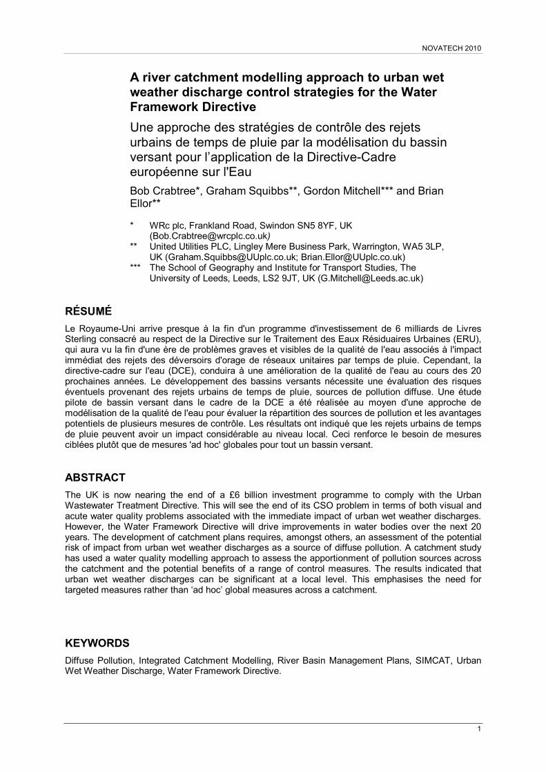
Recently, the EA has developed a national suite of GIS based SIMCAT models for all 11 River Basin Districts in England and Wales (Green et al, 2008). These models are being used for strategic water quality planning and to support the development of the RBMPs. The model for the Ribble-Mersey River Basin District was used to create a SIMCAT model of the River Ribble. This catchment is located in the North West of England, as shown in Figure 1 and, above the freshwater limit at Preston, covers an area of 1540 km2.
In the catchment there are 660 km of river reaches that are required to achieve the WFD water quality standards for ‘good ecological status’ (UKTAG, 2006). The catchment contains:
175 river reaches;
124 routine water quality monitoring sites where samples are collected at monthly intervals;
11 continuous river flow measurement sites;
a total of 42 WTPs operated by United Utilities, with 26 having a population greater than 250 people; serving a population of 700,000 inhabitants; and,
4 industrial discharges and 42 licenced river water abstractions (>30,000m3/year).
Urban areas are concentrated in the Calder and Darwen sub catchments to the south of the Ribble catchment, and rural areas predominate in the north, part of which is included in the Yorkshire Dales National Park.
The SIMCAT model for the Ribble catchment was calibrated for BOD, Ammonia, Phosphate, Nitrate and Dissolved Oxygen using a combination of input data types, including:
point source inputs from United Utilities’ and other industrial WTP effluent discharges;
a national GIS layer of model generated diffuse inputs of Phosphate and Nitrate from agriculture;
sewer catchment model based estimates of CSO and Storm Tank discharge flow and load; and,
model estimates of pollutant loads from urban and highway runoff.
Information for the spatial patterns of diffuse pollution from agriculture, urban runoff and wastewater intermittent discharges, derived from other modelling studies, were provided, respectively, by the Environment Agency, the University of Leeds and United Utilities. In previous studies these proportions have been estimated as a combined total diffuse input during the model calibration phase, making it difficult to correctly apportion the urban/agricultural load inputs across a catchment. The
SESSION 3.9
4
model derived information, as annual loads, allowed a direct quantification and comparison of pollution sources following model calibration. The methods used to estimate point source and agriculture diffuse loads are described elsewhere (Crabtree et al, 2009). The study represented the first attempt to explicitly apportion different pollution sources at a catchment scale using SIMCAT.
Figure 1 Location of the Ribble Catchment and the Main Sub Catchments
2.2 Estimating Urban Wet Weather Pollution Inputs
2.2.1 CSO and Storm Tank Discharges
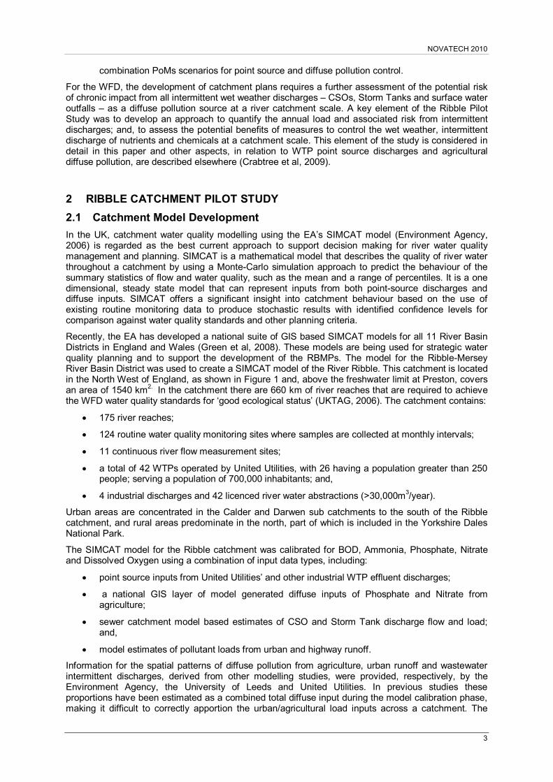
The Ribble Catchment contains over 360 CSOs and Storm Tanks at WTPs. Considerable capital investment has been undertaken on improvements to over 70 CSOs in the catchment over the last 15 years. These improvements were delivered as part of the United Utilities programme to control unsatisfactory CSO and Storm Tank discharges at a cost of over £100 million. This work was focused on the River Darwen and River Calder catchments using UPM methodologies (FWR, 1998). As part of this investment, 15 wastewater network models covering the major conurbations of Blackburn and Burnley were developed for flow, BOD, Ammonia and Suspended Solids. United Utilities created 34 additional wastewater network models for the Ribble Pilot Study to give coverage of all the wastewater networks in the catchment. These new models generally covered the smaller, rural wastewater networks. The urban wastewater systems modelled in the Ribble Catchment are shown in Figure 2.
Contributing permeable and impermeable catchment areas were assessed and all Storm Tanks were included in the models. All models were run with a stochastically produced typical year rainfall series using WRc’s Stormpac® rainfall generater model (WRc, 2009). These were checked against observed rainfall records.
Spill volumes and loads for BOD and Ammonia were extracted from the model simulation results directly. Event mean concentration values were calculated for phosphate and nitrate based on sampling data from previous CSO studies, WTW untreated effluent data, and an assessment of dilution of BOD and Ammonia concentrations from the wastewater network modelling.
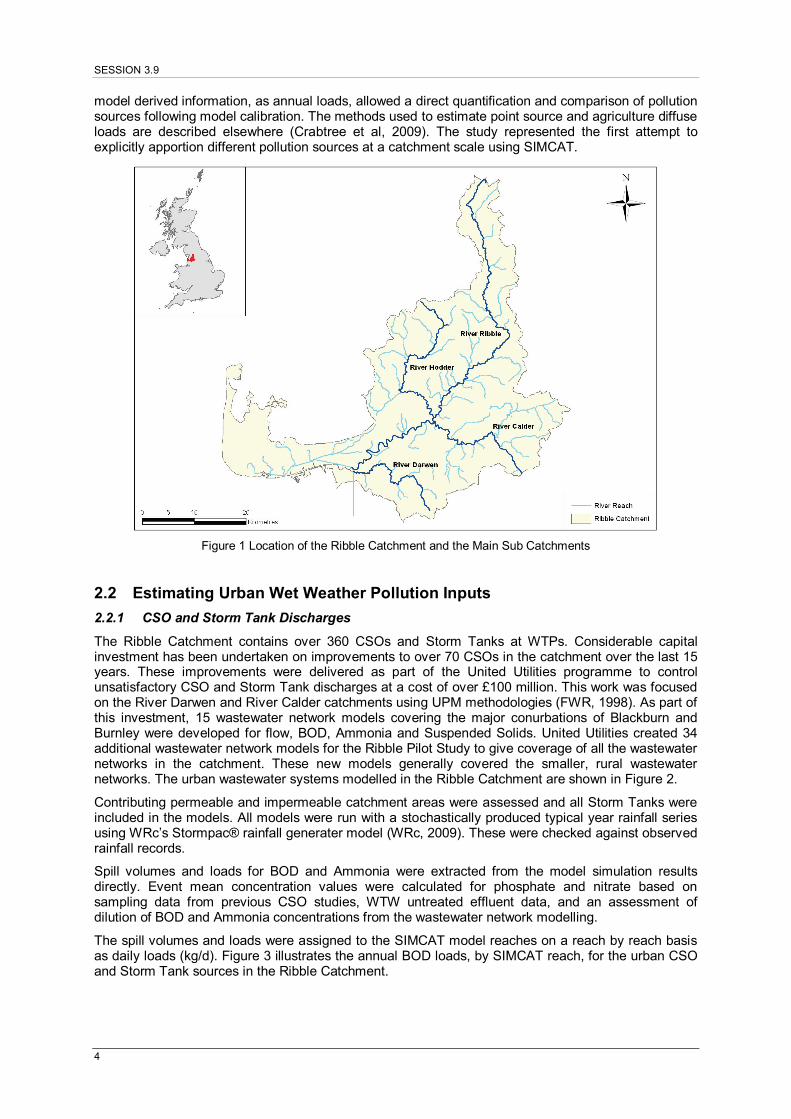
The spill volumes and loads were assigned to the SIMCAT model reaches on a reach by reach basis as daily loads (kg/d). Figure 3 illustrates the annual BOD loads, by SIMCAT reach, for the urban CSO and Storm Tank sources in the Ribble Catchment.
NOVATECH 2010
5
Figure 2 Urban Wastewater Networks Modelled in the Ribble Catchment
Figure 3 Urban CSO and Storm Tank Annual BOD Load Estimates to SIMCAT Reaches
SESSION 3.9
6
2.2.2 Urban Diffuse Inputs: Runoff
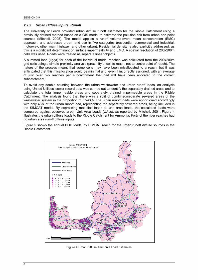
The University of Leeds provided urban diffuse runoff estimates for the Ribble Catchment using a previously defined method based on a GIS model to estimate the pollution risk from urban non-point sources (Mitchell, 2005). The model applies a runoff volume-event mean concentration (EMC) approach, and addresses urban land use in five categories (residential, commercial and industrial, motorway, other main highway, and other urban). Residential density is also explicitly addressed, as this is a significant determinant on surface impermeability and EMC. A spatial resolution of 200x200m cells was used. Roads were treated as separate linear objects.
A summed load (kg/yr) for each of the individual model reaches was calculated from the 200x200m grid cells using a simple proximity analysis (proximity of cell to reach, not to centre point of reach). The nature of the process meant that some cells may have been misallocated to a reach, but it was anticipated that this misallocation would be minimal and, even if incorrectly assigned, with an average of just over two reaches per subcatchment the load will have been allocated to the correct subcatchment,
To avoid any double counting between the urban wastewater and urban runoff loads, an analysis using United Utilities’ sewer record data was carried out to identify the separately drained areas and to calculate the total impermeable areas and separately drained impermeable areas in the Ribble Catchment. The analysis found that there was a split of combined/separate sewered areas of the wastewater system in the proportion of 57/43%. The urban runoff loads were apportioned accordingly with only 43% of the urban runoff load, representing the separately sewered areas, being included in the SIMCAT model. By expressing modelled loads as unit area loads, the calculated loads were compared against observed urban Unit Area Loads (UALs), as reported by Mitchell, 2001. Figure 4 illustrates the urban diffuse loads to the Ribble Catchment for Ammonia. Forty of the river reaches had no urban area runoff diffuse inputs.
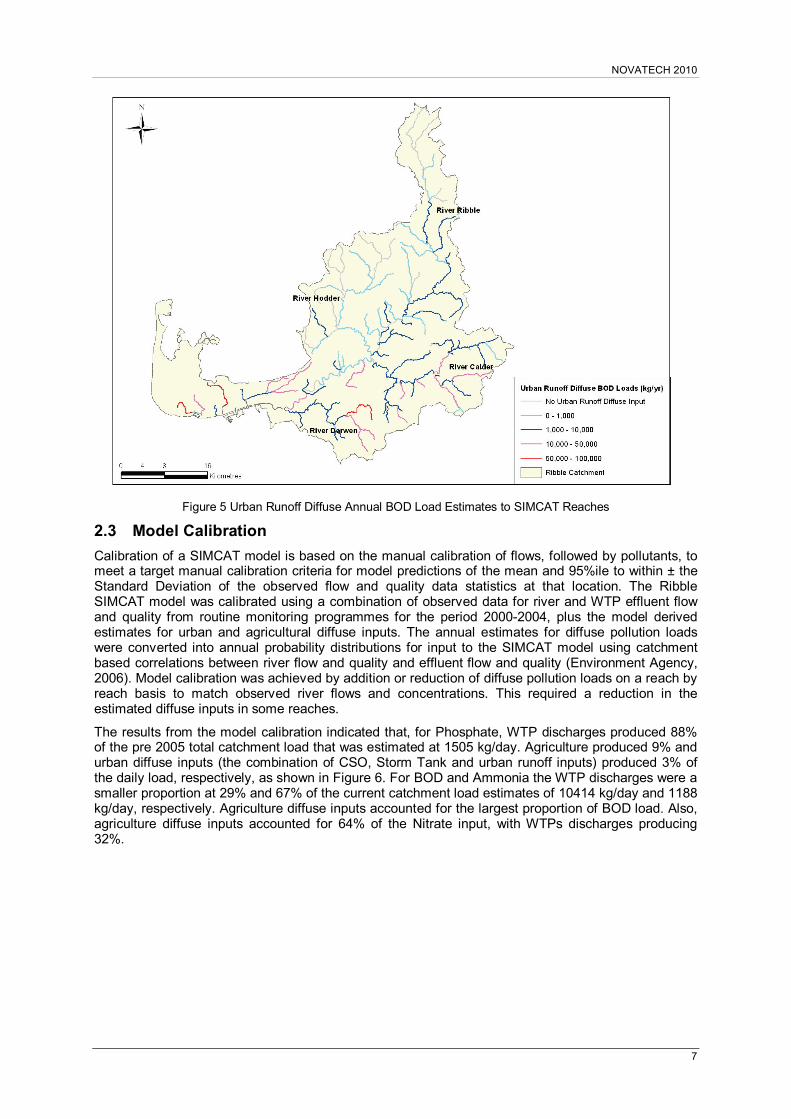
Figure 5 shows the annual BOD loads, by SIMCAT reach for the urban runoff diffuse sources in the Ribble Catchment.
Figure 4 Urban Diffuse Ammonia Load Estimates
NOVATECH 2010
7
Figure 5 Urban Runoff Diffuse Annual BOD Load Estimates to SIMCAT Reaches
2.3 Model Calibration
Calibration of a SIMCAT model is based on the manual calibration of flows, followed by pollutants, to meet a target manual calibration criteria for model predictions of the mean and 95%ile to within ± the Standard Deviation of the observed flow and quality data statistics at that location. The Ribble SIMCAT model was calibrated using a combination of observed data for river and WTP effluent flow and quality from routine monitoring programmes for the period 2000-2004, plus the model derived estimates for urban and agricultural diffuse inputs. The annual estimates for diffuse pollution loads were converted into annual probability distributions for input to the SIMCAT model using catchment based correlations between river flow and quality and effluent flow and quality (Environment Agency, 2006). Model calibration was achieved by addition or reduction of diffuse pollution loads on a reach by reach basis to match observed river flows and concentrations. This required a reduction in the estimated diffuse inputs in some reaches.
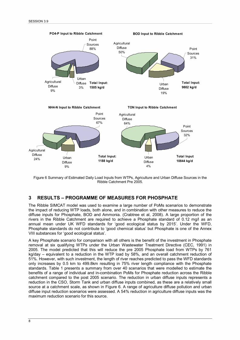
The results from the model calibration indicated that, for Phosphate, WTP discharges produced 88% of the pre 2005 total catchment load that was estimated at 1505 kg/day. Agriculture produced 9% and urban diffuse inputs (the combination of CSO, Storm Tank and urban runoff inputs) produced 3% of the daily load, respectively, as shown in Figure 6. For BOD and Ammonia the WTP discharges were a smaller proportion at 29% and 67% of the current catchment load estimates of 10414 kg/day and 1188 kg/day, respectively. Agriculture diffuse inputs accounted for the largest proportion of BOD load. Also, agriculture diffuse inputs accounted for 64% of the Nitrate input, with WTPs discharges producing 32%.
SESSION 3.9
8
PO4-P Input to Ribble Catchment
Point
Sources88%
Urban Diffuse
3%
Agricultural Diffuse
9%
Total Input: 1505 kg/d
BOD Input to Ribble Catchment
Point Sources
31%
Urban Diffuse19%
Agricultural Diffuse50%
Total Input: 9802 kg/d
NH4-N Input to Ribble Catchment
Agricultural Diffuse24% Urban
Diffuse9%
Point
Sources67%
Total Input: 1188 kg/d
TON Input to Ribble Catchment
Agricultural
Diffuse64%
Urban Diffuse
4%
Point Sources
32%
Total Input:
10844 kg/d
Figure 6 Summary of Estimated Daily Load Inputs from WTPs, Agriculture and Urban Diffuse Sources in the Ribble Catchment Pre 2005.
3 RESULTS – PROGRAMME OF MEASURES FOR PHOSPHATE
The Ribble SIMCAT model was used to examine a large number of PoMs scenarios to demonstrate the impact of reducing WTP loads, both alone, and in combination with other measures to reduce the diffuse inputs for Phosphate, BOD and Ammonia. (Crabtree et al, 2008). A large proportion of the rivers in the Ribble Catchment are required to achieve a Phosphate standard of 0.12 mg/l as an annual mean under UK WFD standards for ‘good ecological status by 2015’. Under the WFD, Phosphate standards do not contribute to ‘good chemical status’ but Phosphate is one of the Annex VIII substances for ‘good ecological status’.
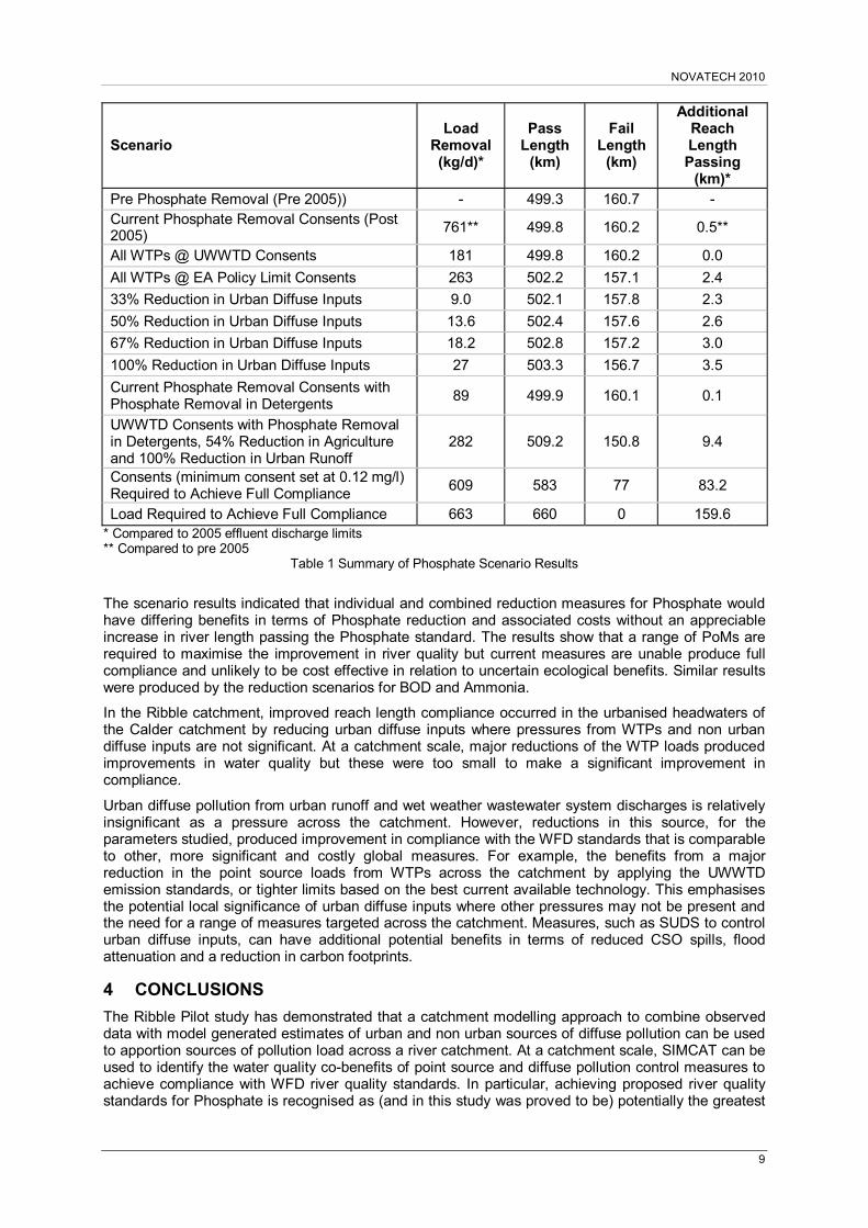
A key Phosphate scenario for comparison with all others is the benefit of the investment in Phosphate removal at six qualifying WTPs under the Urban Wastewater Treatment Directive (CEC, 1991) in 2005. The model predicted that this will reduce the pre 2005 Phosphate load from WTPs by 761 kg/day – equivalent to a reduction in the WTP load by 58%, and an overall catchment reduction of 51%. However, with such investment, the length of river reaches predicted to pass the WFD standards only increases by 0.5 km to 499.8km resulting in 75% river length compliance with the Phosphate standards. Table 1 presents a summary from over 40 scenarios that were modelled to estimate the benefits of a range of individual and in-combination PoMs for Phosphate reduction across the Ribble catchment compared to the post 2005 scenario. The reduction in urban diffuse inputs represents a reduction in the CSO, Storm Tank and urban diffuse inputs combined, as these are a relatively small source at a catchment scale, as shown in Figure 6. A range of agriculture diffuse pollution and urban diffuse input reduction scenarios were assessed. A 54% reduction in agriculture diffuse inputs was the maximum reduction scenario for this source.
NOVATECH 2010
9
Scenario Load
Removal (kg/d)*
Pass Length
(km)
Fail Length
(km)
Additional Reach Length Passing
(km)* Pre Phosphate Removal (Pre 2005)) - 499.3 160.7 - Current Phosphate Removal Consents (Post 2005)
761** 499.8 160.2 0.5**
All WTPs @ UWWTD Consents 181 499.8 160.2 0.0
All WTPs @ EA Policy Limit Consents 263 502.2 157.1 2.4
33% Reduction in Urban Diffuse Inputs 9.0 502.1 157.8 2.3
50% Reduction in Urban Diffuse Inputs 13.6 502.4 157.6 2.6
67% Reduction in Urban Diffuse Inputs 18.2 502.8 157.2 3.0
100% Reduction in Urban Diffuse Inputs 27 503.3 156.7 3.5
Current Phosphate Removal Consents with Phosphate Removal in Detergents
89 499.9 160.1 0.1
UWWTD Consents with Phosphate Removal in Detergents, 54% Reduction in Agriculture and 100% Reduction in Urban Runoff
282 509.2 150.8 9.4
Consents (minimum consent set at 0.12 mg/l) Required to Achieve Full Compliance
609 583 77 83.2
Load Required to Achieve Full Compliance 663 660 0 159.6 * Compared to 2005 effluent discharge limits ** Compared to pre 2005
Table 1 Summary of Phosphate Scenario Results
The scenario results indicated that individual and combined reduction measures for Phosphate would have differing benefits in terms of Phosphate reduction and associated costs without an appreciable increase in river length passing the Phosphate standard. The results show that a range of PoMs are required to maximise the improvement in river quality but current measures are unable produce full compliance and unlikely to be cost effective in relation to uncertain ecological benefits. Similar results were produced by the reduction scenarios for BOD and Ammonia.
In the Ribble catchment, improved reach length compliance occurred in the urbanised headwaters of the Calder catchment by reducing urban diffuse inputs where pressures from WTPs and non urban diffuse inputs are not significant. At a catchment scale, major reductions of the WTP loads produced improvements in water quality but these were too small to make a significant improvement in compliance.
Urban diffuse pollution from urban runoff and wet weather wastewater system discharges is relatively insignificant as a pressure across the catchment. However, reductions in this source, for the parameters studied, produced improvement in compliance with the WFD standards that is comparable to other, more significant and costly global measures. For example, the benefits from a major reduction in the point source loads from WTPs across the catchment by applying the UWWTD emission standards, or tighter limits based on the best current available technology. This emphasises the potential local significance of urban diffuse inputs where other pressures may not be present and the need for a range of measures targeted across the catchment. Measures, such as SUDS to control urban diffuse inputs, can have additional potential benefits in terms of reduced CSO spills, flood attenuation and a reduction in carbon footprints.
4 CONCLUSIONS
The Ribble Pilot study has demonstrated that a catchment modelling approach to combine observed data with model generated estimates of urban and non urban sources of diffuse pollution can be used to apportion sources of pollution load across a river catchment. At a catchment scale, SIMCAT can be used to identify the water quality co-benefits of point source and diffuse pollution control measures to achieve compliance with WFD river quality standards. In particular, achieving proposed river quality standards for Phosphate is recognised as (and in this study was proved to be) potentially the greatest
SESSION 3.9
10
technical and financial challenge to meeting the requirements of the WFD in the UK. The scenario results show that improved, but not full, compliance with the WFD water quality standards could be achieved by point source control alone. However, this would not necessarily reflect a cost effective approach in relation to reductions from all sources. The scenario results indicate that urban diffuse inputs can be relatively small compared to point sources and non urban diffuse pollution at a catchment scale, although the opposite may be the case for other pollutants, such as metals. Importantly, at a local level, urban diffuse inputs from CSOs, Storm Tanks and urban runoff may be significant where there are no pressures from other sources of pollution. In many respects, the issues facing the Ribble catchment are not atypical of other large catchments in England and Wales. The results from the study have helped to inform debate over the cost effectiveness of measures and have demonstrated the scale of some of the technical and economic challenges associated with the development and delivery of WFD River Basin Plans.
The study has demonstrated the benefits of a river basin modelling approach to develop and implement WFD River Basin Management Plans. The results emphasise the need for targeted, measures based on the identification of specific pressures from point and diffuse, continuous and intermittent pollution sources across a catchment. The alternative approach of global measures, such as fixed emission standards or specific sector load reductions, are unlikely to deliver the required environmental outcomes in a cost cost-effective manner. In the future, a catchment modelling approach should ensure that catchments are provided with a satisfactory level of protection at a realistic cost in relation to a range of environmental requirements driven by EC directives.
5 LIST OF REFERENCES CEC (1991). Directive Concerning Wastewater Treatment (91/271/EEC). Official Journal L135, 30 May
1991.
CEC (2002). Council Directive of 23 October 2002 establishing a Framework for Community Action in the Field of Water Policy (2000/60/EEC). Official Journal of the European Communities
Clifforde I, Crabtree R and Andrews H. Living with CSOs – Managing Urban Wet Weather Discharges. World Water and Environmental Engineering (2007), September/October.
Crabtree B, Kelly S, Green H, Squibbs G and Mitchell G (2009) Water Framework Directive catchment planning: a case study apportioning loads and assessing environmental benefits of programmes of measures. Water Science and Technology 59.3, 407-416.
DETR (1997). The Urban Wastewater Treatment (England & Wales) Regulations, 1994: A Guidance Note. Department of the Environment, Transport and the Regions, and the Welsh Office. HMSO, London.
Environment Agency (2008) SIMCAT10.8 – A Guide and Reference for Users.
FWR (1994). Urban Pollution Management Manual. Foundation for Water Research, FR/CL0002.
FWR (1998). Urban Pollution Management Manual, 2nd Edition. Foundation for Water Research, FR/CL0009.
Green, H, Nowosielski A, Kelly S, Dempsey P and Crabtree B (2008) A WFD water quality modelling tool for national scale river basin planning. Proceedings IWA 11th International Specialised Conference on Water shed and River Basin Management, Budapest, September.
Mitchell, G. (2001). The Quality of Urban Stormwater in Britain and Europe: Database and Recommended Values for Strategic Planning Models. Technical Report, School of Geography, University of Leeds, 120 pp.
Mitchell, G. (2005). Pollution Hazard from Urban Non-Point Sources: A GIS-Model to Support UK River Basin Planning. Journal of Environmental Management, 74, 1-9.
UKTAG (2006). UK Environmental Standards and Conditions (Phase 1). Final Report (SR1 – 2006), UK Technical Advisory Group on the Water Framework Directive (www.wfduk.org).
WRc, 2009, http://wrcplc.co.uk/stormpac/
6 ACKNOWLEDGEMENT
This paper has been produced with the permission of the Directors of UKWIR, the Environment Agency, United Utilities, the University of Leeds and WRc plc. The views expressed in the paper are those of the authors and not necessarily the views of these organisations. The authors acknowledge the financial support to the study from UKWIR, the Environment Agency and United Utilities, plus the technical input from Hannah Green of the Environment Agency and Sarah Kelly, formerly with WRc.