x-border-sdi/gdi & aebr - the inspire directive 2007/2/ec ... · project, defacto ready for...
TRANSCRIPT
GI2011 & AEBR-ES Seite 1
X-border-SDI/GDI & AEBR - The INSPIRE Directive 2007/2/EC:
(Interoperability of Spatial Data, Services and Applications)
Challenges and Opportunities for European Border Regions
Doz. Dr. Frank HOFFMANN, CSc IGN - INNOVATION. Grenzüberschreitendes Netzwerk e.V.
c/o IGN-Vorstand, Martin-Andersen-Nexö-Str. 4, D-01217 DRESDEN / Saxony / Germany
[ http://www.FACEBOOK.com/event.php?eid=163068260403141 ] [ Mailto:[email protected] ]
Keywords: Austria, Awareness, Bavaria, Bohemia, Cil3, Cross-border, Directives,Education, ESDI, ETC/3A, Euregio,
Europe, GDI, Geomatics, Geospatial Saxony, GI2000, GI2011, GIS, INSPIRE, Interoperability, INTERREG,
LifeLongLearning, NSDI, OpenGIS, Pilot projects, PSI, RAPIS, Regions, Saxonia, SDI, Spatial planning,
Strategy seminars, Sustainability, Usability, X-border-SDI
Motivation: The 1999 Vision by IGN, the Directives 2003/98/EC and 2007/2/EC and the Invitation 2011 by AEBR
GeoINSPIRE’d Cross-border-Mapping and Statistic Portals for sustainable development of EBR
GEO/ENVIRO/SPATIO Applications from EU/CIP, eCONTENT+ and INTERREG/3A and ETC/4A
X-SDI projects focused on Infrastructure of Spatial Information for Europe (INSPIRE)
GEOPORTAL solutions: X-GDI-NL#NRW <> GIS-Grande#Region <> SIGRS#GISOR <> DACH+
GEOPORTAL solutions & INSPIRE related pilot projects between
Austria<#>Bavaria<#>Bohemia<#>Polonia<#>Saxonia and
The GI2011-X-SDI/GDI-Symposium at 23./24.05.2011 in the “Euregio ELBE#LABE”
Abstract:
The “grass-root” of the INSPIRE Directive 2007/2/EC goes back to the 90ties, when
starting from the so-called CLINTON Order No 12906 in the year 1994. This was the beginning of the
foundation of OGC (OpenGIS Consortium in 1995, now called the Open Geospatial Consortium), as
well the start of GSDI (The Global Spatial Data Infrastructure Conferences, which actually has been
transformed into the GSDI Association). At the same time in 1995 the European Commission started
similar initiatives at Directorate III (Industry) and Directorate VIII (Environment) to support spatial
and environmental decision making in Europe of Regions.
A spatial GI discussion forum was created 1997 by EC/JRC-Ispra, the so-called EGIP-List
(European GeoInformation Policy). It ended up with intensive discussions on the vision, mission and
conception of the GI2000 Initiative as an integrated ESDI (European Spatial Data Infrastructure)
project, defacto ready for submission just after the 5th EC GI&GIS Workshop in Stresa/Italy in
summer 1999 but, unfortunately, it was cancelled in December 1999 in spite of urged demission of the
European Commission.
After revival of the GI2000 conception in Dublin 2002 and INSPIRE initial EC approval
in 2004, as well as the adoption of the new INSPIRE Directive later on in 2007, the geopolitical
decision process moved very slowly not only in European Member states, but also in Saxony. Finally,
the INSPIRE Data and Service Sharing Guidelines of the European COMMISSION REGULATION
No 268/2010 as of 29 March 2010 have been published at April 28th 2010. This Regulation is aiming
to introduce OPEN ACCESS conditions to spatial datasets, information services and thematical
applications (georesource using, environmental monitoring and regional planning) not only inside of
the EC institutions and agencies in order to give them the opportunity to harmonize and integrate
geodata supplied from all Member states in a standardized syntactic and semantic for environmental
and spatial planning processes, but as well for regional/cross-border organizations and local
communities.
GI2011 & AEBR-ES Seite 2
But, the main barriers and, as well important challenges are the INSPIRE semantic geodata
harmonization and geoservice integration of national GI infrastructures across the state borders !
These pre-conditions seem to be obviously from a cartographic viewpoint since GI2000
already (see Proceedings of GI2010-Symposium-DRESDEN, pp. 38-40) and therefore, have been the
main focus behind our NGO foundation of IGN e.V. (INNOVATION. Cross-border-Network)
Association in 2002/2003, as well as developing our GI2000 Strategy seminars, Awareness, Training
and Continuing Education Courses (about 400 GIS experts have been post-graduated in cooperation
with word-leading GIS providers like ESRI and INTERGRAPH etc.) and organizing of cross-border
GI2000 - GI2010 Symposia in Dresden/Saxony with special focus on Euregia in Northern Bohemia
(CZ), LowerSilesia (PL) and Saxonia (DE).
Therefore, this (to be planned remotely) presentation gives a selected overview on the very
few, only 6-8 still existing X-border-Geoportal initiatives, as well as X-SDI-Portal pilot projects
dealing with topographic, topologic and semantic interoperability, usability and sustainability of
re-using geodata, webservices and PLAN4ALL applications across local, regional and state borders
(see Proceedings of GI2010-Symposium-DRESDEN, pp.41-42) in order to informing and making the
community of nearly 200 European Border Regions aware of the PSI & INSPIRE challenges ahead.
Well-known X-border-SDI pilot examples of 200 ( ? ) European Border Regions to
be analyzed and presented, but limited by presentation time…
X-DP-PLIS: Cross-border German-Polish Planning Information System DE<>PL
X-GDI-NL / NW: Cross-border Geodata Infrastructure NL <> DE (NI+NRW)
X-GDI-GrandeRegion: Cross-border Data Infrastructure of BE<>CH<>DE<>FR<>LU
X-GDI-SIGRS / GISOR: Cross-border Data Infrastructure of CH<>FR<>DE
X-GDI-BODENSEE / DACH+: Cross-border SDI for AT<>CH<>DE (BW+BY)<>LI
X-GDI-CENTROPE-MAP: Cross-border Spatial Planning Portal AT<>CZ<>HU<>SK
X-GDI-SUMAVA: Cross-border ATKIS & ZABAGED Harmonisation CZ(PLZ)<>DE(BY)
X-GDI-NNR: NaturNet+Redime Project Tools for X-SDI-Testing AT<>CZ<>DE
X-CROSS-DATA: X-border-ETC/3A Spatial Information Planning System CZ<4 Euregia>DE(SN)
X-RegioGDI-RAPIS: Raumplanungs-Informationssystem X-Region-Sachsen
European eCONTENT+ Network: Research Project “PLAN4ALL”
European LLP-Programme LEONARDO: Project “SDI+EDU for Urban and Spatial planning”
TThheerreeffoorree,, CCCCSSSS ((PPrraahhaa)),, IIGGNN ((DDrreessddeenn)) aanndd UUnniiWWBB ((PPllzzeenn)) aarree iinnvviittiinngg tthhee MMeemmbbeerrss ooff aallll
EEuurrooppeeaann BBoorrddeerr RReeggiioonnss ffoorr eexxcchhaannggiinngg iinnffoorrmmaattiioonn,, eexxppeerrttiissee aanndd iinnnnoovvaattiioonn pprroojjeeccttss aatt tthhee
GGII22001111--XX--bboorrddeerr--SSDDII//GGDDII--SSyymmppoossiiuumm
ttoo bbee hheelldd iinn tthhee ccrroossss--bboorrddeerr ““EEuurreeggiioo EELLBBEE##LLAABBEE”” !!
2233.. MMaayy 22001111:: BBaadd SScchhaannddaauu ((SSAAXX))
2244.. MMaayy 22001111:: DDeecciinn ((CCZZEE))
MMoorree iinnffoo aatt::
[[ hhttttpp::////wwwwww..IIGGNN--SSNN..ddee//GGII22001111//GGII22001111++ooppeennccaallll..ppddff ]]
[[ hhttttpp::////IINNSSPPIIRREE--FFoorruumm..jjrrcc..eecc..eeuurrooppaa..eeuu//ppgg//bblloogg//DDRREESSDDEENN//rreeaadd//3344444499 ]]
[[ hhttttpp::////wwwwww..vveeccttoorr11mmeeddiiaa..ccoomm//nneewwss//ttoopp--ssttoorriieess//7799--eevveenntt//1177994455--ggii22001111--xx--ssddiiggddii--ssyymmppoossiiuumm..hhttmmll ]]
GI2011 & AEBR-ES Seite 3
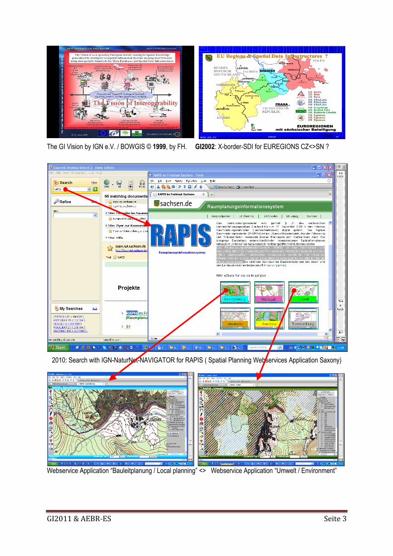
The GI Vision by IGN e.V. / BOWGIS © 1999, by FH. GI2002: X-border-SDI for EUREGIONS CZ<>SN ?
2010: Search with IGN-NaturNet-NAVIGATOR for RAPIS ( Spatial Planning Webservices Application Saxony)
Webservice Application “Bauleitplanung / Local planning” <> Webservice Application “Umwelt / Environment”
27GI2002BOW_GIS_FH
EU Regions & Spatial DataEU Regions & Spatial Data Infrastructures ?Infrastructures ?
GI2011 & AEBR-ES Seite 4
REFERENCES:
BELOF: Reflections on SDI for spatial planning cooperation and support programmes across the borders of Euroregions.
In: [ Proceedings GI2010-Symposium-DRESDEN, p. 24 ] and GI2010-Presentation.
BELOF: New Instruments For New Challenges In Transborder Planning Co-Operation Between Poland And Czech
Republic. In: [ Proceedings GI2010-Symposium-DRESDEN, p. 25 (Preprint) ].
BLACHOWSKI et al: Concept of Regional Monitoring of Spatial Planning for Lower Silesia in the X-border Context of
European Projects GMES & Plan4All. In: [ Proceedings GI2010-Symposium-DRESDEN, p.27 ]
BOW (Bildungswerk Ost-West): Die OpenGIS-Strategie, GeoDatenManagement und OpenALKIS.
Konsequenzen für Innovation und Weiterbildung in Sachsen. GIStrategie-Seminarserie GI2000 und GI2002.
CDROM-2000 und CDROM-2002; Edited by F. HOFFMANN. Dresden: BOW2000 & BOW2002
CHARVAT: The “WAY 4 INSPIRE” - SEIS versus SISE Approaches.
In: [ Proceedings GI2010-Symposium-DRESDEN, p. 28 ] + GI2010-Presentation.
Directive 90/313/EEC: Freedom of Access to environmental information
[ http://eur-lex.europa.eu/LexUriServ/LexUriServ.do?uri=CELEX:31990L0313:EN:HTML ]
EC-GI&GIS: The GI2000-Initiatives (1995-1999)
[ http://www.ec-gis.org/copygi2000/ ]
EEA (European Environment Agency): Public ACCESS to Environmental Information
[ http://www.eea.europa.eu/92-9167-020-0/ ]
European Commission: Towards a Single Information Space for the Environment in Europe.
SISE Experts Consultation Workshop, Brussels: 15th February 2008
[ http://cordis.europa.eu/fp7/ict/sustainable-growth/workshops/ws-20080215_en.html ]
European Commission: Environment - Shared Environmental Information System - SEIS
[ http://ec.europa.eu/environment/seis/index.htm ]
EU-FP6/7-Projects NaturNet+Redime (NNR), NaturNet+, Plan4All and SDI-EDU:
[ http://www.NaturNet.org ] +[ http://portal.NaturNet.org ] +[ http://www.plan4all.eu ] +[ http://sdi-edu.zcu.cz ]
HOFFMANN: Statement at the Final Panel Discussion. 5th EC-GI/GIS Workshop, STRESA: June 30th, 1999.
[ http://www.ign-sn.de/GI2009/vision_1999.pdf ]
HOFFMANN (Editor): GI2008-Symposium - 8. Sächsisches GIS-Forum, Dresden 2008
[ http://www.epsiplus.net/reports/gi2008_dresden_symposium_may_2008 ]
HOFFMANN (Editor): GI2009-Symposium: - 9. Sächsisches GIS-Forum, Dresden 2009
[ http://www.epsiplatform.eu/reports/gi2009_dresden_symposium_may_2009 ]
HOFFMANN (Editor): GI2010-Symposium: - 10. Sächsisches GIS-Forum, Dresden 2010, 97 pp.
[ http://www.epsiplatform.net/news/news/gi2010_10th_anniversary_symposium ]
[ http://www.epsiplatform.net/news/news/dresden_gi2010_symposium_publishes ]
IGN e.V.: WEBLOG Geospatial SAXONY
[ http://GDI-SN.blogspot.com ] + [ http://www.IGN-SN.de ] + [ http://www.GDI-SN.de ]
IGN e.V. @EU-INSPIRE-Forum:
[ http://inspire-forum.jrc.ec.europa.eu/pg/profile/DRESDEN ]
INSPIRE-News-FEED (09.07.2010): Krakow Declaration on INSPIRE - The Krakow Declaration on INSPIRE was
approved at the Closing Session of the Conference "INSPIRE as a framework for cooperation", 23-25 June, 2010
[ http://inspire.jrc.ec.europa.eu/index.cfm/newsid/10081 ]
[ http://inspire.jrc.ec.europa.eu/documents/INSPIRE_/Krakow_INSPIRE_2010_Declaration.pdf ]
JANECKA et al.: The EU - Leonardo da Vinci - Project “SDI-EDU for regional & urban planning “
The “Status quo” of INSPIRE Awareness at Local and Regional Level.
In: [ Proceedings GI2010-Symposium-DRESDEN, pp. 43-46 ] + GI2010-Presentation.
MEDIENSERVICE SACHSEN: Rauminformations- und Planungssystem für den sächsisch-böhmischen Grenzraum
[ http://www.medienservice.sachsen.de/medien/news/136307 ]
MILDORF & JANECKA: eContentplus Project “PLAN4ALL” - Spatial Planning Integration in Europe.
In: [ Proceedings GI2010-Symposium-DRESDEN, pp. 69-70 ] + GI2010-Presentation
RAPIS: Regionales Raumplanungs-Informations-System Sachsen
[ http://egov.rpl.sachsen.de/rapis_portal.html ]
VDV-News-FEED (08.07.2010): Kooperation der Landesvermessungen von Niederlanden und Deutschland
[ Drei Landesvermessungen - ein gemeinsames Produkt ]
X-border-GDI (DE<>NL):
[ http://www.x-border-gdi.org/en/geolab/index.html ]
[ http://interreg.intaboweb03.net/intabox/medienarchive/schulung/091221_X-Border-GDI%20ronduit_DE.pdf ]