thÈse prÉsentÉe À comme exigence partielle … · encuentran basicamente concentradas en très...
TRANSCRIPT

UNIVERSITÉ DU QUÉBEC À MONTRÉAL
THÈSE PRÉSENTÉE À
L'UNIVERSITÉ DU QUÉBEC À CHICOUTIMI
COMME EXIGENCE PARTIELLE
DU DOCTORAT EN RESSOURCES MINÉRALES
OFFERT À
L'UNIVERSITÉ DU QUÉBEC À MONTRÉAL
EN VERTU D'UN PROTOCOLE D'ENTENTE
AVEC
L'UNIVERSITÉ DU QUÉBEC À CHICOUTIMI
PAR
FERNANDO PRECIOZZI PORTA
PETROGRAPHY AND GEOCHEMISTRY OF FIVE GRANITIC PLUTONS
FROM SOUTH-CENTRAL URUGUAY: CONTRIBUTION TO THE
KNOWLEDGE OF THE PIEDRA ALTA TERRANE
(PÉTROGRAPHIE ET GÉOCHIMIE DE CINQ PLUTONS GRANITIQUES
DU CENTRE-SUD DE L'URUGUAY:
CONTRIBUTION À LA CONNAISSANCE DU TERRAIN
PIEDRA ALTA)
NOVEMBRE 1993

bibliothèquePaul-Emile-Bouletj
UIUQAC
Mise en garde/Advice
Afin de rendre accessible au plusgrand nombre le résultat destravaux de recherche menés par sesétudiants gradués et dans l'esprit desrègles qui régissent le dépôt et ladiffusion des mémoires et thèsesproduits dans cette Institution,l'Université du Québec àChicoutimi (UQAC) est fière derendre accessible une versioncomplète et gratuite de cette �uvre.
Motivated by a desire to make theresults of its graduate students'research accessible to all, and inaccordance with the rulesgoverning the acceptation anddiffusion of dissertations andtheses in this Institution, theUniversité du Québec àChicoutimi (UQAC) is proud tomake a complete version of thiswork available at no cost to thereader.
L'auteur conserve néanmoins lapropriété du droit d'auteur quiprotège ce mémoire ou cette thèse.Ni le mémoire ou la thèse ni desextraits substantiels de ceux-ci nepeuvent être imprimés ou autrementreproduits sans son autorisation.
The author retains ownership of thecopyright of this dissertation orthesis. Neither the dissertation orthesis, nor substantial extracts fromit, may be printed or otherwisereproduced without the author'spermission.

11
Les granitoïdes dans le centre-sud de l'Uruguay sont
concentrés principalement en trois ceintures métamorphiques
d'orientation est-ouest. Il s'agit (du sud vers le nord) des
Ceintures de Montevideo, de San José et d'Arroyo Grande
respectivement. Ces ceintures sont séparées les unes des autres
par des bandes de gneiss de composition granitiques. Toutes ces
roches, les ceintures ainsi que les gneiss, constituent
collectivement le Terrane de Piedra AIta.
Cinq de ces plutons granitiques, deux de la Ceinture de
San José et trois de la Ceinture d'Arroyo Grande, ont été
étudiés en détail. La composition chimique de 86 échantillons
(éléments majeurs et traces) a été déterminée. Ces données,
ainsi que des données isotopiques Rb-Sr, démontrent que,
typiquement, ces plutons sont de nature composite et que l'âge
des différentes unités varie entre 1900 Ma à 2500 Ma. Les âges
plus anciens proviennent des unités principales des plutons
eux-mêmes tandis que les âges plus récents correspondent à
l'âge de mise-en-place des dykes qui se sont injectés dans les
plutons pré-existants et qui ne sont pas nécessairement
associés à ces plutons. Les plutons sont généralement (mais pas
exclusivement) du type calco-alcalin et sont typiquement syn-
orogéniques tandis que les dykes sont post-orogéniques et sont
de composition soit calco-alcaline soit alcaline.
Ces données sont incorporées en un modèle tectonique pour
le Terrane de Piedra Alta qui est différent, à plusieurs

Ill
niveaux, que le modèle actuel. L'essentiel de l'évolution
géologique de la région est:
1) développement d'un vieux «socle» de gneiss granitique
2) déposition, sur ou adjacent à ce «socle» de gneiss
granitique, d'une séquence assez semblable à une complexe de
schiste-verte archéen, bien qu'aucune komatiite n'a été
découverte à date.
3) métamorphisme paléoprotérozoique, suivi par la mise-en-place
des roches plutoniques syn-tectoniques à post-tectoniques.
4) développement d'accidents tectoniques importantes associés
à l'orogenèse Tranamazonienne.
5) mise-en-place des dykes (post-orogéniques à anorogéniques)
à la suite de l'orogenèse Transamazonienne.

iv
Abstract
Granitoid rocks in south-central Uruguay are largely
concentrated in three east-west trending metamorphic belts,
known as (from south to north) the Montevideo Belt, the San
José Belt and the Arroyo Grande Belt. These belts are separated
from one another by intervening bands of gneisses of granitic
composition. The whole assemblage, the gneisses as well as the
metamorphic belts and their associated granites, collectively
constitute the Piedra Alta Terrane.
Five of these granite plutons, two from the San José Belt
and three from the Arroyo Grande Belt, have been studied in
some detail and the chemical composition of 86 samples (major
elements as well as a selected suite of trace elements) have
been determined. These data, as well as Rb-Sr isotopic data,
show that these plutons are typically composite in nature, and
that the various units range in age from 1900 Ma to 2500 Ma.
The older ages were obtained from the main units of the plutons
themselves whereas the younger ages are from late dykes which
were emplaced into the plutons and which are clearly not
related to them. The plutons are predominantly, but not
exclusively, of calc-alkaline affinity and are typically syn-
orogenic whereas the dykes are post-orogenic and are either
calc-alkaline or alkaline in composition.
These data have been incorporated into a tectonic model
for the Piedra Alta Terrane which is considerably different

from that heretofore proposed. The essential features of the
geological history of the area are:
1) development of an older "basement" of granitic gneisses
2) deposition, upon or adjacent to this gneisses basement, of
a typical Archean greenstone belt assemblage (no komatiites so
far reported)
3) Paleo-proterozoic metamorphism, followed by syn-tectonic to
post-tectonic intrusion of the plutonic rocks
4) major tectonic dislocation(s) associated with the
Transamazonian orogeny
5) dyke emplacement (post-orogenic to anorogenic) following the
Transamazonian orogeny

Resumen
Las rocas granitoides del sur y centro del Uruguay se
encuentran basicamente concentradas en très cinturones
metamôrficos de direcciones régionales E - W, conocidos de
norte a sur como Cinturon Montevideo, San José y Arroyo Grande.
Estos cinturones estan separados unos de otros por fajas de
neises de composiciôn granitica. Todo el conjunto, los neises
asi como los cinturones metamôrficos y los granitos asociados,
colectivamente constituyen el Terreno Piedra Alta.
Cinco de estos plutones graniticos, dos del cinturôn San
José y très del cinturôn Arroyo Grande han sido estudiados en
detalle y la composiciôn quimica de 86 muestras (elementos
mayores, asi como elementos trazas) han sido determinados.
Estos datos, asi como las determinaciones geocronolôgicas
Rb-Sr, muestran que estos plutones son de naturaleza compleja
y que las distintas unidades varian en el entorno 1900 m.a. a
2500 m.a. Las edades mayores han sido obtenidas en las unidades
principales de los plutones, mientras que las mas jôvenes
corresponden a filones tardios emplazados en los mismos, no
estando relacionados a ellos. Los plutones son
predominantemente de afinidad calco- alcalina siendo
tipicamente sin-orogénicos, mientras que los filones son post
- orogénicos de composiciones alcalinas o calco-alcalinas.
Estos datos han sido incorporados a un modelo tectônico
para el Terreno Piedra Alta, que considerablemente difiere del
propuesto hasta el présente. Las principales caracteristicas de

vii
la historia geolôgica del area son: 1) desarrollo de un
basamento antiguo de neises graniticos. 2) deposiciôn sobre o
adjacentes a este basamento neisico de tipicos conjuntos de
cinturones arqueanos (greenstone belt) - komatiitas no nan sido
registradas. 3) metamorfismo paleo-proterozoico seguido por
intrusiones de rocas plutonicas sintectônicas a postectônicas.
4) dislocaciones tectonicas mayores associadas a la orogenesis
Transamazônica. 5)emplazamiento de filones (post-orogenicos a
anorogénicos) siguiendo la orogenesis Transamazônica.

viii
Acknowledgements
The author first wishes to acknowledge the co-operation
and logistical support of DI.NA.MI.GE. in making this project
possible. The study of the Predevonian rocks of Uruguay has
preoccupied the writer for many years, and during the course of
this work he has had the pleasure of interacting and exchanging
ideas with several colleagues interested in similar problems.
It is with great pleasure that I acknowledge my scientific debt
to Drs. J. Bossi and N. Campai - I thank them for many hours of
stimulating discussion and the cross-pollination of scientific
ideas. I would also like to express my sincere thanks to
Professor Luis Dalla Salda, of the Universidad Nacional de la
Plata in La Plata, Argentina, for many useful comments made on
an earlier version of this manuscript and for many hours of
friendly discussion.
The author would also like to thank Dr. J. Bourne for his
useful scientific input, for correcting the English text of
this manuscript, and for piloting the thesis through the
various stages of the administrative process.
Dr. Ron Doig of McGill University kindly made available a
computer programme for carrying out the Rb-Sr isochron
calculations and provided valuable advice on the interpretation
of the results. His collaboration is much appreciated.
Chapter 1 of this thesis was submitted to the Journal of
South American Earth Sciences and has been accepted for
publication. The author benefitted from two excellent reviews

IX
by Drs. Roberto Caminos and Carlos Rapela and their comments
and suggestions have been incorporated into chapter l. The
writer would also like to thank Dr. Victor Ramos, regional
editor of the Journal of South American Earth Sciences, for
sheparding the manuscript through the review process so rapidly
and so painlessly.
À grant from the Université du Québec à Montréal enabled
the author to spend a year at the university working on this
project. He would like to acknowledge the enthuiasm of Dr.
Gilbert Prichonnet of UQAM who encouraged him to embark upon
this project. Many of the diagrams were draughted by Mme.
Michelle Laithier of UQAM, and the author would like to
apologize for the many versions of several of the diagrams
which she cheerfully prepared.
Finally, I note that the computer program of Clarke (1990)
greatly facilitated data analysis.

A note on the format of the thesis
The manuscript presented below is in the form of three
largely autonomous chapters. Each chapter has its own title,
introduction et cetera. The diagrams found in chapter one are
labelled 1-1, 1-2 and so on. To avoid repetition, the
references for all three chapters have been placed at the end
of the thesis. The format style for the references is that
required by the Journal of South American Earth Sciences.
It is acknowledged that, in adopting this format, there is
an unavoidable duplication of some material, particularly among
the introductory figures in each chapter. The writer can only
express the hope that this does not cause unnecessary annoyance
to potential users.
Each of these three chapters has been submitted for
publication. Chapter 1 has been accepted for publication in the
Journal of South American Earth Sciences. Chapter 2 has been
submitted to the Revista de la Sociedad Brasileira de
Geociencias and at the time of writing the author is awaiting
the comments of the reviewers. Chapter 3 has been published by
Bossi et al., (1993) in a publication of the Government of
Uruguay, written in both Spanish and English, and entitled "El
Predevoniano del Uruguay/The Predevonian of Uruguay".

XI
TABLE OF CONTENTS
Résumé ii
Abstract iv
Resumen vi
Acknowledgements viii
A note on the format of the thesis x
Table of Contents xi
List of Figures xv
List of Tables xix
Sommaire détaillé xx
Introduction
Introduction 1
Comment on Nomenclature 7
Xll
Chapter 1Foreward to chapter 1 9
Introduction 10
Geological setting 13
PetrographyArroyo de la Virgen Pluton 13
granodiorite 16leucogranite 17aplite dykes 17porphyritic diorite dyke 18
Isla Mala Pluton 19granodiorite and related rocks 20microgranodiorite 20leucogranite 21hornblendite 22late dykes 22enclaves 23
Geochemistry 23
Discussion 30Geochronology and constraints on magma source . . . 30Depth of emplacement 34Chemical classification of the tectonic setting . . 35Implications for tectonic history 39
Conclusions 43
Chapter 2
Foreward to chapter 2 45
Introduction 46
Geological Setting 47
Petrography 51Marincho Complex 51
main unit 51hornblendite and associated granodiorite . . . 52leucogranite 53
South Granite 54Arroyo Grande Pluton 54
Geochronology 55
Geochemistry 59

XX11
Discussion 65Pressure of emplacement 65Chemical classification of tectonic setting . . . . 68Timing of intrusion 72Analogies with the Abitibi Belt of Canada 73Comparison with the southern portion of the . . . . 75Uruguay Crystalline BeltContribution to a tectonic model 76
Conclusions 79
Chapter 3
Foreward to chapter 3 81
Introduction 83
I: The volcano-sedimentary belts 83Arroyo Grande Belt 83
Petrography of the detrital sequence 84Petrography of the volcanic sequence 87Metamorphic mineral assemblages 88Tectonic evolution 89
San José Belt 94Outline of the petrography of the San José Belt 97Tectonic history of the San José Belt 98Metamorphic assemblages . . 100
Montevideo Belt 101Metamorphic observations 106Tectonic history 107
II: The granitic gneiss complex 107

xiv
III: Intrusive rocks 118Plutonic rocks associated with metamorphic belts . . 119
Arroyo Grande Belt 119Classification diagrams 122
San José Belt 124Field evidence 125Mahoma - Cufré region 126
Petrography of the plutons 126Montevideo Belt 137
Basic Magmatism 140Montevideo Belt orthoamphibolites 141Berrondo orthoamphibolites 141Hornblendites 142Gabbros 144Mafic dyke swarm * 146
IV: Tectonics 153Summary of the pertinent data for the model . . . . 156The proposed model 159The relationship of the Montevideo Belt 163Possible correlations on a larger scale 164Closing comment 167Conclusions 168
References 169
Appendix 1
Piedra Alta terrane 178
Sarandi del Yi - Piriapolis lineament 183
Nico Perez terrane 184
Cuchilla - Dionisio belt 185
Brazilian magmatogenesis 188
Distensional magraatism . 189

XV
List of FiguresIntroduction
Figure i-1: Location of the three Predevonianterranes of Uruguay
List of FiguresChapter l
Figure I.I) Geological sketch map of Uruguay showingthe location of the study area and theFlorida - Conchillas belt, southern Uruguay 12
Figure 1.2) Sketch map of the local geology in thevicinity of the AVP and the IMP 14
Figure 1.3) Streckeisen (1976) diagram for the AVPand the IMP 15
Figure 1.4) AFM diagram for the AVP (4a) and theIMP (4b) 31
Figure 1.5) MgO - SiO2 plot for the AVP (5a) and theIMP (5b) 32
Figure 1.6) Normative quartz - albite - orthoclase diagramfor the most evolved plutonic analyses fromthe AVP 36
Figure 1.7) FeO*/(FeO* + MgO) - SiO2 plot for theAVP (7a) and the IMP (7b) 38
Figure 1.8) Tectonic discriminant diagram for the AVP (8a)and the IMP (8b) 41

XVI
List of FiguresChapter 2
Figure II.1) Geological sketch map of Uruguay showing thelocation of the study area, central Uruguay 48
Figure II.2) Sketch map of the local geology showing thelocations of the three plutons studied . . . 50
Figure II.3) Isochrons for the various members of theMarincho Complex, the South Granite, andgranitic blocks 58
Figure II.4) P-Q classification diagram for the AGP (4a) 62and the MC and SG (4b) 63
Figure II.5) AFM diagram for the AGP (5a) and the MC andSG (5b) 66
Figure II.6) Normative quartz - albite - orthoclase diagramfor the most evolved plutonic analyses from theAGP (6a) and the MC and SG (6b) 67
Figure II.7) FeO*/(FeO* + MgO) - SiO2 plot for the AGP (7a)and the MC and SG (7b) 69
Figure II.8) Tectonic discriminant diagram for theAGP (8a) and the MC and SG (8b) 71

XVI1
Figure III.l)
Figure III.2)
Figure III.3)
Figure III.4)
Figure III.5)
Figure III.6)
Figure III.7)
Figure III.8)
Figure III.9)
Figure III.10)
Figure III.Il)
Figure III.12)
Figure III.13)
List of FiguresChapter 3
Location map of the departments as wellas many of the place names mentionedin the text 82
Sketch map showing the location of the threemetamorphic belts of southern Uruguay . 85
Geological map of the Arroyo Grande Belt 86
Stereonet showing the contrast between theeastward and westward plunge of stretchinglineations and microfold axes in the easternand western portions of theArroyo Grande Belt 90
(5b) Geological sketch map of the San JoséBelt. The rectangular area shown on FigureIII.5b has been enlarged and presented asFigure III.5a, on which regional structuraltrend lines have also been shown . . . 96
Geological sketch map of theMontevideo Belt 105
Trend lines for the granitic gneiss complexand the San José Belt, southern Uruguay(after Campai, 1990) 109
Detailed trend surface map for gneissesand related rock near the town of La Cruz,Department of Florida 110
Detailed structural map of the gneissesand related rocks near the town of CerroColorado 112
Outcrop-scale map of the granitoid intrusionsin the Piedra Alta Quarry, near the city ofFlorida 114
Distribution of granitoid intrusions in thePiedra Alta Terrane, southern Uruguay . 121
Modal mineral plot for rocks of the MarinchoComplex 123
Distribution of granitoid plutons in the SanJosé Belt 127

XVI11
Figure III.14) Chemical zonation in the Isla Mala Complex asrevealed by variation in plagioclasecompositions 128
Figure III.15) Structural elements within the Isla MalaComplex 129
Figure III.16) Series of sketches showing the proposedevolution of the Isla Mala Complex . . . 131
Figure III.17) Modal mineral plot of the Cufré, Cerro SanJosé, Mal Abrigo and Mahoma Plutons . . 132
Figure III.18) R1-R2 classification diagram for the Cufré,Cerro San José and Mai Abrigo Plutons . 13 3
Figure III.19) Tectonic discriminant diagram for the Cufré,Cerro San José and Mai Abrigo Plutons (afterBatchelor and Bowden, 1985) 135
Figure III.20) Tectonic discriminant diagram for the Cufré,Cerro San José and Mai Abrigo (after Maniarand Piccoli, 1989) 136
Figure III.21) Geological Sketch map of the Mahoma Pluton,San José Belt 145
Figure III.22) Distribution of late basic dykes in thePiedra Alta Terrane 148
Figure III.23) R1-R2 classification diagram for the latedyke swarm, showing the presence of twodistinct groups of basic dykes 149
Figure III.24) Summary of the available radiometric agedata for rocks of the Piedra AltaTerrane 158
Figure III.25) Main cratonic blocks and allochthonousterranes of southern South America.Horizontal lines indicate the extent of theAlto Paraguay Terrane(after Ramos, 1988) 165
List of FiguresAppendix
Figure A.I) Geological sketch map of southern Uruguay,showing the location of the different "terranes" . . . . 180
Figure A.2) Geological-structural map of the southernpart of the Dionisio Belt 186
XIX
List of TablesIntroduction
Table i-1) Stratigraphie sequence proposed for theUruguayan Predevonian rocks and Transamazonian -Brazilian tectonic events 5
List of TablesChapter 1
Table I.I) Chemical analyses of the Arroyo de la
Virgen Pluton 24
Table 1.2) Chemical analyses of the Isla Mala Pluton . . 26
Table 1.3) Geochronologial data for the Arroyo de laVirgen and Isla Mala Plutons 3 3
List of TablesChapter 2
Table II.1) Results of radiometric age determinationsfor various members of the Marincho Complex,the South Granite, and granitic blocks. . . 57
Table II.2) Chemical analyses of the Arroyo Grande,South Granite and Marincho Complexintrusions 60
List of TablesChapter 3
Table III.l) Mineral assemblages observed in the ArroyoGrande Belt 91
Table III.2) Tectonic events recorded in the Arroyo GrandeBelt 95
Table III.3) Tectonic events recorded in theSan José Belt 99
Table III.4) Summary of measured age determinations fromthe southern granitic gneiss complex . . . . 120
Table III.5) Summary of the pétrographie characteristicsof the two groups of mafic dykes 152
XX
SOMMAIRE DETAILLE
La synthèse géologique de l'Uruguay, publié en 1991 par Bossi
et Navarro était basée sur des documents publié jusqu'à 1986.
Depuis, les connaissances sur la géologie des roches
Precambriennes de l'Uruguay n'ont cessé d'augmenter, surtout
grâce aux travaux de cartographie exectués par les équipes
géologiques du Gouvernement de l'Uruguay ainsi que des études
académiques effectués par des chercheurs Uruguaiens et de
l'étranger. Ce document représente à la fois une contribution
académique aux connaissances géologiques de l'Uruguay, et en
même temps une tentative de synthèse ou d'intégration de toutes
les données disponibles depuis de janvier, 1992.
Un survol de la géologie de l'Uruguay est présenté en Annexe
1. L'essentiel est répété ici comme introduction pour ceux et
celles qui connaissent que très peu la géologie de mon pays.
Essentiellement, il existe deux grands groupes de roches en
Uruguay: (1) les roches déformés (une ou plusieurs fois) qui
consistent en schistes et gneisses de composition et de faciès
métamorphiques assez variés, et (2) des roches sédimentaires et
volcaniques non-déformés qui reposent en discordance angulaire
sur les roches du premier groupe. Toutes les roches du deuxième
groupe sont d'âge dévonien ou plus jeunes. Pour cette raison,
les roches du groupe 1 porte le nom de "pré-dévonien de
l'Uruguay".

XXI
Les roches pré-dévoniennes ont été sub-divisées en trois
groupes qui sont, de l'ouest vers l'est: (1) le terrane de
Piedra Alta (2) le terrane de Nico Perez et (3) la ceinture
Cuchilla - Dionisio.
Le terrane de Piedra Alta consiste en une vaste région de
gneisses, schistes et roches intrusives, toutes les unités
étant de composition variable. Selon Bossi et Navarro (1991),
les roches du Piedra Alta ont été métamorphisées et déformées
lors de l'orogenèse Transamazonienne (2000 Ma - 1800 Ma). Le
but principal de cet travail est de démontrer que ce scénario
est d'une part trop simpliste, et qu'il faut proposer
l'existence d'au moins deux périodes de déformation pour
expliquer les observations actuellement connues.
Le terrane de Nico-Perez est semblable, à plusieurs points du
vue, aux roches du terrane de Piedra Alta. Par contre, les deux
terranes sont séparés par une importante zone de mylonite de 15
km de puissance - le linéament de Sarandi del Yi - Piriapolis.
Le déplacement horizontal le long de cette zone de faille étant
inconnu, il est donc impossible d'affirmer que les roches des
deux terranes étaient les mêmes à l'origine. La grande
différence entre le Nico Perez et le Piedra Alta réside dans le
fait que que les roches du Nico Perez ont été reprises plus
tard par l'orogenèse Brésilien (1000 Ma - 650 Ma), ce qui
complique l'interprétation géologique de ce terrane.
XX11
La ceinture Cuchilla - Dionisio contient également des
gneisses, schistes et roches intrusives de diverses
compositions. Les roches de cette zone ont été affectées
seulement par l'orogenèse Brésilien et on ignore, du moins pour
le moment, la présence des roches anciennes dans ce terrane.
Cette thèse consiste en une étude effectuée à l'intérieur du
terrane de Piedra AIta (TPA) exclusivement. Afin que le lecteur
puisse apprécier la contribution scientifique que représente ce
travail, il est nécessaire de présenter quelques petites
informations sur la géologie de cette zone.
Trois ceintures dit "volcano-sédimentaires" ont été
identifiées à l'intérieur du TPA. Ils sont, du nord vers le
sud: (1) la Ceinture de 1'Arroyo Grande (métamorphisme schiste
vert inférieur à moyen) (2) la Ceinture de San José
(métamorphisme schiste vert supérieur) et (3) la Ceinture de
Montevideo (métamorphisme dans le faciès amphibolite). La
proportion des roches sédimentaires et volcaniques varient
d'une ceinture à l'autre. Les trois ceintures sont séparées les
unes des autres par deux domaines de gneiss, amphibolites et
migmatites fortement métamorphisés et déformés dans le faciès
amphibolite supérieur ou granulite.
Un certain nombre de roches plutoniques ont été cartographiées
à l'intérieur des trois ceintures volcano-sédimentaires. La
composition de ces roches intrusives varient entre gabbro et
leucogranite et les textures varient de massive à folié.

XXI11
L'étude géochimique et géochronologique de deux plutons du
secteur oriental de la Ceinture de San José ainsi que trois
plutons de la Ceinture de 1'Arroyo Grande représente la partie
principale de ce travail, (chapitres 1 et 2 respectivement).
Une synthèse de toutes les connaissances géologiques de la
région, incluant les résultats des premiers deux chapitres, est
présenté dans le chapitre 3 qui a comme but de proposer un
modèle cohérent pour expliquer les données géologiques connues.
Auparavant, le modèle tectonique expliquant l'évolution
géologique du terrane de Piedra Alta était assez simple. Les
datations sur quelques roches intrusives et métamorphiques,
pris dans les ceintures volcano-sedimentaires ainsi que dans
les gneiss, donnaient des âges entre 2100 Ma et 1900 Ma. En
conséquence, on pensait que les roches de cette région avaient
été affectées par l'orogenèse Transamazonienne exclusivement.
Les données présentées ci-dessous compliquent légèrement ce
modèle.
Les résultats de l'étude des Plutons de 1'Arroyo de la Virgen
et de Isla Mala, situés dans la Ceinture de San José, sont
présentés en Chapitre 1. La cartographie de 1'Arroyo de la
Virgen dévoile la présence d'une intrusion zonée, qui passe de
granodiorite dans le nord vers un leucogranite plus au sud.
L'intrusion fut recoupé par une variété de dykes. Des datations
de ces roches (toutes les datations citées dans ce texte ont
été effectué par la méthode Rb-Sr sur roche totale) ont donné
des âges de 2225 Ma pour le leucogranite et 1925 Ma et 1894 Ma

XXIV
pour deux dykes de composition légèrement différente. Ces
résultats indiquent que les dykes sont beaucoup plus jeunes
(d'âge tardi-Transamazonien) que l'intrusion - ils ne peuvent
pas être le "dernier jus" associé à la mise en place de la
partie principale du massif. L'âge du leucogranite était
surprenant - le pluton est une roche massive et non-deformée,
mais l'âge est PRE-Transamazonien.
La cartographie du Pluton de Isla Mala a également dévoilé la
présence de deux unités principales (granodiorite et
leucogranite) recoupé par des dykes tardifs. L'âge déterminé
pour un de ces dykes est 2040 Ma - tout à fait comparable aux
dykes qui recoupent 1'Arroyo de la Virgen. Par contre, l'âge de
mise en place du granodiorite et du leucogranite ont été fixés
à 2450 Ma et 2290 Ma respectivement. Ceci démontre que les deux
unités principales de l'Isla Mala n'étaient pas contemporaines
et qu'il s'agit d'un "pluton à l'intérieur d'un pluton". Pour
cette raison, nous préférons le terme "Complexe d'Isla Mala"
pour décrire l'ensemble des unités.
Le leucogranite et le granodiorite sont tous les deux de
texture massive et d'âge pre-Transamazonien. Ce résuit confirme
que l'âge pre-Transamazonien pour le leucogranite de 1'Arroyo
de la Virgen n'est pas aberrant.

XXV
Les résultats pour les plutons de Marincho, le South Granite
(granite du sud) et 1'Arroyo Grande, tous localisés dans la
Ceinture de 1'Arroyo Grande, sont présentés en Chapitre 2.
Le granodiorite de 1'Arroyo Grande est le moins connu de ces
trois amas intrusifs. Il est massif et, à l'état actuel de nos
connaissances, de composition homogène. La composition
légèrement subalcaline suggère un environnement distensif pour
la mise en place. Aucune datation n'est disponible pour cette
intrusion.
Le South Granite est un leucogranite massif de composition
homogène. Une datation sur ce granite a donné un âge de 2180
Ma, ce qui est légèrement plus jeune que l'âge de 2225 Ma
déterminé pour 1'Arroyo de la Virgen.
Plusieurs unités cartographiables ont été identifiés dans
l'intrusion de Marincho. Les trois unités les plus importantes
sont une hornblendite (d'âge inconnu), un granodiorite (2291
Ma) et un leucogranite (2067 Ma). Il s'agit encore un fois d'un
ensemble polyphasé, ce qui nous amène à appliquer le terme
Complexe de Marincho pour toutes ces roches. Un dyke de
leucogranite qui recoupe le complexe, a été daté à 1969 Ma,
semblable aux âges des dykes de la Ceinture de San José plus au
sud.
La limite australe de la Ceinture de 1'Arroyo Grande est la
Faille del Paso de Lugo. Les gneiss granitiques sont situés au
sud de cette faille. Quelques blocs de granite massif ont été
découverts dans la zone de faille. Une datation sur ces blocs
XXVI
a donné un âge de 2544 Ma - la plus vieille roche reconnue à
date dans la région. Cette datation laisse supposer que la
déformation, qui a affecté les roches des ceintures volcano-
sédimentaires, était antérieure à 2544 Ma - c'est à dire, d'âge
archéen.
Le Chapitre 3 présente une synthèse qui intègre non seulement
les résultats de ce travail mais aussi tous les travaux
antérieurs effectués dans la région. Le but est d'utiliser
toutes les informations disponibles afin de proposer un modèle
tectonique qui concorde avec toutes ces données. La majeure
partie de ce chapitre présente des données essentielles qui
servent de base pour l'élaboration du modèle. Ces informations
étant assez longues et détaillées, nous nous contenterons ici
de présenter les éléments les plus importants du modèle qui en
découle.
Etape #1
II est plus ou moins certain maintenant que les roches les
plus vieilles de la région sont d'âge archéen. Les évidences
appuyant cette affirmation sont:
1) les roches des ceintures volcano-sédimentaires ont été
déformées et métamorphisées au faciès schiste vert ou
amphibolite.
2) des blocs du granite massif, échantillonnés à l'intérieur de
la zone de faille de Paso de Lugo, (ceinture septentrionale)
ont été datés à 2544 Ma.

XXVI1
3) le granodiorite d'Isla Mala, (ceinture centrale), qui est
également massif, a été daté à 2450 Ma.
Le fait que ces derniers deux granites sont massifs indiquent
que l'âge de la déformation affectant les ceintures volcano-
sédimentaires était encore plus vieux. Si on accepte la date de
2500 Ma, proposée par la Geological Society of America comme
limite entre 1'archéen et le protérozoïque, alors la
déformation qui a affecté les ceintures volcano-sédimentaires
était certainement d'âge archéen dans le nord du TPA et
probablement d'âge archéen également dans le centre du TPA.
On note aussi le rapport initiel de 0.734 obtenu sur le
leucogranite du Complexe de Marincho (1969 Ma). Un tel rapport
suggère que ce leucogranite est le produit de la fusion
partielle d'une croûte continentale assez vieille (sans doute
archéen), mais il est impossible d'être plus précis.
Etape #2
Un certain nombre des roches datées dans le cadre de ce projet
se situent dans une intervalle de 2450 Ma jusqu'à 2180 Ma dont
la plupart entre 2290 Ma et 2180 Ma. Les roches les plus
vieilles sont caractérisées par une chimie calco-alcaline
tandis que les plus jeunes sont plutôt de chimie alcaline - les
leucogranites ne peuvent être classé par cette technique à
cause de leurs particularités chimiques. Ceci suggère un
passage graduel entre un environnement syn-tectonique à post-

xxviii
tectonique et ceci pendant une période d'environs 110 Ma. Des
études géochronologiques effectuées au Brésil suggèrent que les
importantes zones de failles et de mylonites, tels que le Paso
del Lugo entre autres, se sont développées pendant cette
période.
Etape #3
Un deuxième regroupement temporel de roches intrusives se
situe entre 2040 Ma et 1894 Ma. Toutes ces roches sont des
petits dykes qui recoupent les plus grands amas intrusifs
développés lors du deuxième étape. Encore un fois, les roches
les plus vieilles semblent être caractérisées par une chimie
calco-alcaline tandis que les roches plus jeunes sont plutôt
alcalines. Le pluton d'Arroyo Grande est définitivement à
caractère alcalin, mais pour le moment aucune datation n'est
disponible.
On note que le pluton de Mahoma, situé plus vers l'ouest en
dehors du secteur considéré dans ce rapport, a été daté à 1935
Ma. Ceci démontre que les roches intrusives développées lors de
cette troisième étape ne sont pas exclusivement des petits
dykes.
Collage tectonique
La séquence de roches décrites ci dessus sont toutes situées
à l'intérieur de trois ceintures volcano-sédimentaires
séparées, les unes des autres, par de vastes zones de "gneiss
XXIX
granitiques". Les datations Rb-Sr sur ces gneiss donnent des
valeurs entre 2200 Ma et 2000 Ma. Ces âges, interprétés comme
âges métamorphiques, représentent la date à laquelle la roche
a refroidi à des températures inférieurs à la température de
"blocage" pour ce système isotopique - vers 500°C selon la
plupart des géochronologues. De tels datations sont
traditionellement attribuées à l'orogenèse Transamazonienne.
Ces données sont très difficile à interpréter car ils amènent
immédiatement à une contradiction. Les ceintures volcano-
sédimentaires contiennent, surtout dans le nord (ceinture de
Arroyo Grande) les assemblages métamorphiques qui caractérisent
le faciès schiste vert. Les massifs granitiques, logés dans ces
ceintures, semblent être non-déformés et d'âge 2290 Ma à 2180
Ma. Ces ceintures sont séparées des gneiss granitiques (d'âge
2200 Ma à 2000 Ma, donc post-granite) par des importantes zones
de failles, qui sont également des zones de "discontinuité
métamorphique". Il est peu probable que l'événement
métamorphique reponsable pour le développement des gneiss
granitiques était la même que celui qui a donnée naissance aux
assemblages métamorphiques dans les ceintures volcano-
sédimentaires. Il s'agit donc de deux événements métamorphiques
distincts - un qui a affecté les ceintures volcano-
sédimentaires (archéen ?) et l'autre qui a produit les gneiss
granitiques, migmatites et granulites (2200 Ma - 2000 Ma). Le
collage structurale de ces deux composantes en un grand terrane
précambrien fut donc réalisée après que le deuxième

XXX
métamorphisme soit, en grand partie, terminé. La grande
contradiction mentionné ci dessus réside dans le fait qu'il
existe aucune évidence supportant une hypothèse de collage
tectonique post-2000 Ma. Au contraire, l'âge proposé pour le
développement des zones de failles est de 2263 Ma - c'est à
dire pre-Transamazonien. Cet âge est nettement en conflit avec
l'âge du métamorphisme des gneiss granitiques. Des datations
radiometriques additionelles seront nécessaires afin de régler
ce problème. Une étude géochronologique approfondie représente
la prochaiane étape pour améliorer nos connaissances du pré-
dévonien de l'Uruguay.
Introduction
Two years ago, Bossi and Navarro (1991) published their
benchmark article entitled "The Geology of Uruguay". The
manuscript of this article was completed in 1988 and the
geology therein described was up to date as of approximately
1986.
Since this article was completed, our knowledge of the
"Predevonian Crystalline shield", one of the major components
of Uruguayan geology, has been significantly improved - 1:100
000 scale mapping projects have been carried out on several key
areas of the predevonian rocks. A university group (College of
Agronomy) supported by I.R.D.C. (International Research
Development Center) concentrated on the Middle Precambrian
rocks. Similarily DI.NA.MI.GE. (Mining and Geology National
Direction) staff of "Basic Geology Division" carried out an
analogous work in the Late-Proterozoic - Cambrian igneous-
metamorphic belt developed in the eastern part of the country.
Finally, there have been a number of independent studies, such
as that described in chapters 1 and 2 of this report, as well
as several others, which have all contributed to our
understanding of the pre-Devonian rocks of Uruguay.
A compilation of the above cited information was made in
order to produce a synthesis of what is known of the
predevonian rocks. It is hoped that this synthesis will prove
useful not only for Uruguayan geologists but also for those who
are interested in the geology of South American as a whole.

We note that, during the course of this synthesis, it was
necessary to critically analyze the available data, to weigh
its relevance and to evaluate them in the light of current
hypotheses.
The goal was to construct a model which encompasses every valid
opinion about such a difficult and vast subject.
Up to the present, the Uruguayan Predevonian Shield has
only been studied on a small or local scale. The degree of
available detail is variable and the models derived from these
were also very different. Therefore, in order to produce a
coherent whole, it was necessary to reinterpret almost all pre-
existing work.
It is recognized that many readers, particularily North
American readers, may initially find the subject somewhat
confusing due to a lack of familiarity with the geology of the
area. To help overcome this obstacle, the writer has prepared
a short overview of the Precambrian geology of Uruguay, which
is included here as Appendix 1. Some of the material presented
in this Appendix is discussed in considerably more detail in
the body of the text, particularily in chapter 3. Although
nothing which is presented in the Appendix is indispensable for
an understanding of what follows, it should nevertheless
provide a general basis for comprehension of the geology of
this portion of South America.
The classic subdivision of the Precambrian of Uruguay of
Ferrando and Fernandez (1971) was founded on the proposed

existence of two orogenic events: a Limpopo-Kibali event dating
from approximately 2000 Ma and a Baikalian event of
approximately 500 to 600 Ma. This proposal was based on the
geochronological data of Umpierre and Halpern (1971).
Unfortunately this scheme is not adequate to explain the
geology of the region as currently known. Nevertheless, their
hypothesis represented a significant advance in the knowledge
of Uruguayan (and South American) geology from a tectono-
chronostratigraphic point of view. Both Bossi et al. (1975) and
Preciozzi et al. (1985) accepted the validity of this
subdivision. A new proposal involving three orogenic cycles by
Bossi (1983) has not proven to be totally satisfactory for
explaining the available data. Recently Bossi and Navarro
(1991) proposed a new stratigraphie sequence for the Uruguayan
Predevonian rocks which is outlined in Table i-1.
For a number of reasons it is now considered preferable to
divide the Predevonian rocks into different terranes, each of
which can be characterized by a number of distinctive features
such as rock type, predominant structural trend et cetera. The
three Predevonian terranes currently recognized are shown in
Figure i-1. Two groups of plutonic rocks, one from southern
Uruguay and the other from central Uruguay, are described in
this report in chapters 1 and 2 respectively. These data have
been incorporated, along with data from all other available
sources, into a synthesis of the current state of geological
knowledge of the Piedra Alta Terrane. This synthesis is

presented here as chapter 3 of this thesis and it is the
writer's hope that it is an accurate, coherent and meaningful
synthesis of our current knowledge of the Piedra Alta Terrane.

TABLE i-1Stratigraphie sequence proposed for the Uruguayan Predevonian
rocks and Transamazonian - Brazilian tectonic events
Aae fMai Stratigraphie units Rock types
485 - 545 Sierra de los Rios FmSierra de las Animas Fm
515 - 550 La Paz and Illescasgranites
Late Orogenic Cycle
blastomylonites
510 - 550535 - 590610 - 670
900 +\- 50
Sierra Ballena Fm
Barriga Negra FmPost orogenic granitesSyn orogenic granitesMigmatitesCarapé Group
Lavalleja andRocha groupsPiedras de Afilar FmPre orogenic volcanism
RhyolitesSyenites,
microsyenites,trachytes,basalts
Medium gradeectinitesLow gradeectinitesSedimentsGreenschists
Early Orogenic Cycle
1930 +\- 35
1900 - 20501930 - 2170
Older Basement
Post and late orogenicgranitesSyn orogenic granitesMigmatites, gneissesand pegmatitesMontevideo, Paso Severinoand Arroyo Grande Fms.
Valentines Fm
Cunapiru-Vichaderocrystalline region
Differentgrade metamor-
phic rockswith slight
migmatization
Banded IronFormation
after Bossi (1983)
58
Sierra BallenaShear Zone
Sarandi del Yi-Pirapolis Lineament
-RochaGroup
Punta del Este58
YSA Mesosilicic Late-Cambrianmagmatism
Dyke swarm
54°
Cuchilla Dionisio Belt
Nico Perez Terrane
Piedra Alta Terrane
Figure i-1: Location of the three Predevonian terranes of
Uruguay
Comment on Nomenclature
As seen on Figure i-1, the Piedra Alta Terrane occupies the
western portion of the Predevonian Shield of Uruguay. This area
has long been known as the "Rio de la Plata Craton", a term
introduced by Almeida (1973, 1976) to replace the term "Zocalo
de la Cuenca del Rio de la Plata" (base of the Rio de la Plata
Basin) proposed earlier by Ferrando and Fernandez (1971). The
behaviour of this unit as a stable craton during the Brasilian
orogenic cycle was surely the reason why Ferrando and Fernandez
chose this term for these rocks. Nevertheless, an analysis of
its geological evolution is more reasonably arrived at by
considering the inherent characteristics of the belt itself,
rather than only taking into account its age relationship with
respect to the Late-Proterozoic - Cambrian mobile belt.
For reasons outlined below, the author proposes that the
term Rio de la Plata Craton, with its associated geotectonic
implication, be set aside and replaced by the more operational
term Piedra Alta Terrane. Herve and Mpodozis (1991) define
tectono-stratigraphic terranes as being those areas which have
geological histories which differ from those of other
neighbouring areas. We use the term Piedra Alta Terrane in the
tectono-stratigraphic sense.
CHAPTER I
PETROGRAPHY AND GEOCHEMISTRY OF THEARROYO DE LA VIRGEN AND ISLA MALA PLUTONS,
SOUTHERN URUGUAY: EARLY PROTEROZOIC TECTONIC IMPLICATIONS

Foreward to Chapter 1
The largest of the three metamorphic belts referred to in
the introduction is the San José Belt. The belt is host to a
number of granitoid intrusions which are distributed more or
less indiscriminantly along its entire length. Two of the
larger intrusions, both of which are situated at the eastern
end of the belt, were chosen for a geochemical and
geochronological study. The goals of the project were:
1) to characterize the tectonic environment of emplacement of
the granitoids
2) to determine their age of crystallization
3) to relate this information to currently available models for
the tectonic evolution of southern Uruguay.
The results of this study are presented below as chapter
1.

10
Introduction
The southern half of Uruguay is underlain by a wide
variety of Precambrian rocks which have been metamorphosed to
grades ranging from greenschist to granulite. Two main age
groupings have been identified based on the age of the
deformation which later affected them. The two groupings are
separated by a number of NNE trending mylonite zones up to 5 km
in width which trend approximately parallel to the eastern
coast of South America, (Figure I.l). Rocks east of the
mylonite zones are mostly of Brazilian age in that they were
influenced by the Brazilian orogeny which affected the area
between 500 Ma - 650 Ma. Rocks west of the mylonite zones were
deformed during the Transamazonian orogeny, which dates from
1900 Ma - 2100 Ma, as well as during earlier events, (Cordani
et al., 1988). An overview of Uruguayan geology is available in
Preciozzi et al., (1985).
Both the Transamazonian rocks, and to a lesser extent the
Brazilian rocks, are hidden by extensive outcroppings of flat-
lying sedimentary rocks ranging in age from Devonian to
Quaternary and also by flat-lying volcanic rocks ranging in age
from Jurassic to Cretaceous, notably the tholeiitic basalts of
the Arapey Formation which underlie the central and
northwestern portions of Uruguay, (Mantovani and Hawkesworth,
1991).
The predominant structural trend of the Transamazonian
rocks is east-west except near the mylonite zones. The

11
metamorphic grade of the different rock units often varies
suddenly as lithologie contacts are crossed. These metamorphic
discontinuities suggest the presence of stacked gneiss sheets
(Davidson et al., 1982).
The fault zones which separate these metamorphic
discontinuities are characterized by the presence of mylonitic
rocks. Intrusive into these schists and gneisses are a number
of plutonic bodies which are concentrated in four distinct
areas. The largest of these is located between the town of
Florida and the village of Conchillas in southern Uruguay and
consists of 20 intrusions exposed over a strike length of
approximately 160 km, (Figure I.I). The Arroyo de la Virgen
Pluton (AVP) and the Isla Mala Pluton (IMP), located at the
eastern end of this belt are the largest (80 km2 and 50 km2
respectively) and amongst the better exposed members of this
suite of intrusions, the centre of which is located
approximately 90 km north of Montevideo. Radiometric data, to
be presented below, clearly indicates that the IMP is in fact
a composite body, consisting of two units which are separated
in age by approximately 150 Ma. To be consistent with earlier
terminology, we refer to both of them as the IMP.
The purpose of this article is to describe the petrography
and geochemistry of these plutons and to use this information
to draw some inferences concerning the Middle Precambrian
tectonic evolution of Uruguay.

12
BRAZIL
30°S � Ou,
35°S
5 5 ° W - .
Mesozoic and Cenozoic rocks1 ' (excluding Arapey Formation)
V Arapey Formation (tholeiitic basalts)
', /\ 1 Permian-Carboniferous rocks
Rocks deformed during Transamazonian event
Rio de la Plata Craton
Nico Perez terrane
Rocks deformedduring Brazilian event
^ ^ P Transamazoniangranitoid intrusion
�g^îz- Mylonite zone
-~� Fault
J-^J- Limit ofPrecambrian rocks
Figure I.I: Geological sketch map of Uruguay showing thelocation of the study area, southern Uruguay.

13
Geological Setting
Both the AVP and the IMP are intrusive into several
different rock types, (Figure 1.2). Low grade metamorphic rocks
of the Paso Severino Formation (slates, phyllites, quartzites,
meta-arkoses and metavolcanic rocks) are located along the
southern and western margins of the pluton (Preciozzi et al.,
1979; 1985). Ortho-amphibolitic rocks of the Berrondo unit and
a lithologically complex suite of migmatites (the Pintado unit)
are found along the northern and southeastern margins of the
mass respectively.
Petrography
a) Arroyo de la Virgen Pluton fAVP)
The main portion of the intrusion consists of a massive,
grey, coarse-grained, relatively homogeneous, biotite (rarely
hornblende) granodiorite, (Figure 1.3). A pinkish, coarse-
grained, homogeneous leucogranite is located in the southern
portion of the outcrop area of the complex and a homogeneous,
porphyritic microdiorite has been observed locally within the
main granodioritic unit. Finally, a series of late diorite,
aplite and fine-grained pinkish granite dykes cross cut the
main unit of the complex.
The AVP does not contain many enclaves, however the
mylonitic nature of some of these enclaves suggests that the
AVP is younger than the tectonic event which brought the low
grade and high grade rocks into mutual contact, Furthermore,

14
KM
LEGEND
Fault
Thrust fault
\ \ First deformation\ N phase of
x Transamazonianevent
l:.:.;.;iV.-':J Quaternary
EARLY PROTEROZOIC
Pintado Unit (gneisses andmigmatites)
|v v| Berrondo Unit(orthoamphibolites)San Jose Formation (highgrade amphibolite rocks)Paso Severino Formation(metasedimentary andmetavolcanic rocks)
ISLA MALA COMPLEXx Granodiorites
i^j^j MicrogranodioritesA A | LeucogranitesHUH Late dykesllllllllllllll Diorites^ ^ B Hornblendites
ARROYO DE LA VIRGENCOMPLEX
+ | Granodiorites+ + -| Leucogranites
Vein granites
MIDDLE PROTEROZOIC
Within plate mafics
Figure 1.2) Sketch map of the local geology in the vicinity ofthé AVP and the IMP.

15
ARROYO DE LAVIRGEN PLUTON
A Late dykeso Leucogranite� Granodiorite
ISLAMALA
PLUTON GRANITE \GRANOJ
\DIORITE
� Late leucogranite dykes� Hornblendites
Main unitLate dioritic dykes
Figure 1,3) Streckeisen (1976) diagram for the AVP and the IMP,After Preciozzi (1989a, 1989d)

16
the fault zones observed in the country rocks do not cross the
ÀVP.
Granodiorite (main unit)
Euhedral plagioclase crystals, situated within an
hypidiomorphic granular matrix, is the texture typically
encountered within the intrusion. The plagioclase crystals have
been variably altered to secondary epidote and sericite.
The composition of the granodiorite is heterogeneous and
is characterized by a well developed pétrographie zoning, as
revealed by the An content of plagioclase which varies
systematically from An 20 values along the eastern, northern
and western margins of the mass to An 0 values in the south-
central portion of the complex.
The potassium feldspar phase is a microcline perthite in
which the type of perthite ranges from acicular to vermiform to
cryptoperthite and microperthite (Ailing, 1938). The microcline
is typically anhedral, although occasional subhedral crystal
forms, and more rare poikilitic forms were also observed.
Phyllic alteration phenomena are frequently present.
The quartz forms anhedral crystals which feature undulose
extinction and numerous sub-grain boundaries. Two generations
of quartz were observed depending on the tendency to form
polygonal aggregates. This form of quartz tends to be found in
those rocks which have the lower An values discussed above. The
biotite is strongly pleochroic in shades of olive green, has

X /
been replaced by chlorite to a minor extent, and contains
inclusions of zircon, apatite, sphene and opaque minerals.
Leucogranite
The rocks features a clear hypidiomorphic granular texture
with subhedral albite. The albite shows several different
styles of alteration, however the most important is
phyllitization.
Microcline is abundant, being present in large anhedral to
subhedral crystals which are occasionally poikilitic. Small
veinlets of albite, of acicular and occasionally tabular form,
are also present.
The quartz, which forms clear anhedral crystals comparable
in size to the microcline crystals, has a well developed
undulatory extinction.
Deep red biotite crystals, containing inclusions of
radioactive minerals, are present. Muscovite forms subparallel
laths in contact with the biotite. Accessory minerals include
red garnet, bipyramidal zircon, sphene, apatite, and rarely
iron oxides.
Aplite Dykes (vein granites)
The aplite dykes possess hypidiomorphic granular textures,
however some rocks have clearly porphyritic tendencies. The
plagioclases are subhedral, of oligoclase composition and are
frequently altered. The potassium feldspar consists either of
18
anhedral, granular perthitic microcline or of subhedral
phenocrysts which may be slightly porphyritic. Phyllitic
alteration is present to different degrees.
The quartz, which is relatively abundant, consists either
of crystals of subhedral, equigranular quartz or forms part of
the fine-grained matrix of the dykes along with microcline and
plagioclase.
Red biotite crystals are relatively abundant. The
accessory phases include zircon, apatite, sphene and iron
oxides.
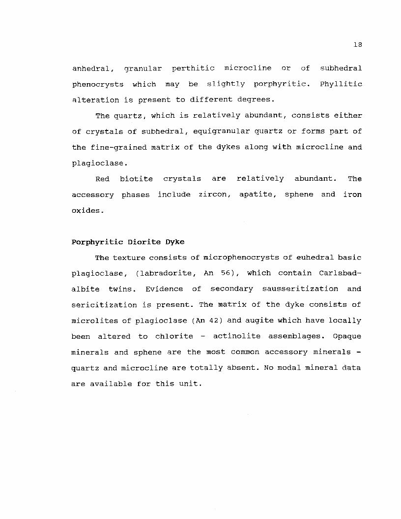
Porphyritic Diorite Dyke
The texture consists of microphenocrysts of euhedral basic
plagioclase, (labradorite, An 56), which contain Carlsbad-
albite twins. Evidence of secondary sausseritization and
sericitization is present. The matrix of the dyke consists of
microlites of plagioclase (An 42) and augite which have locally
been altered to chlorite - actinolite assemblages. Opaque
minerals and sphene are the most common accessory minerals -
quartz and microcline are totally absent. No modal mineral data
are available for this unit.

19
b) Isla Mala Pluton fTMP)
A medium-grained, hornblende + biotite granodiorite is the
most important rock type encountered in the IMP, however the
composition of the intrusion varies from "diorite" through to
monzogranite, (Figure 1.3). The hornblende and biotite are
oriented parallel to the contact near the margin of the
intrusion. A similar orientation, which is also parallel to the
long axis of enclaves of schist and amphibolite, was observed
near the western and southern contacts of the mass. In the
centre of the pluton the rocks are massive.
A network of small E-W trending dykes of diorite and
granite are found in the west-central portion of the complex.
In addition, a small stock of porphyroblastic hornblendite was
observed near the centre of the intrusion. Two distinct bodies
of fine-grained diorite (microgranodiorite) and pale pink
leuocogranite are found along the southern margin of the IMP.
The age of the hornblendite and the microgranodiorite are not
known. The chemistry of these units is similar to that of the
main portion of the mass and it is assumed, for lack of
evidence to the contrary, that the pluton developed by multiple
injection from a deeper magma source. Age data for the
leucogranite, presented below, suggest that this unit is
substantially younger.
The slate unit of the Paso Severino formation has been
converted into an andalusite-bearing hornfels at the contact
with the leucogranite.

20
Granodiorite and related rocks
The granodiorite features a hypidiomorphic granular
texture with abundant euhedral plagioclase which is typically
calcic oligoclase in composition and is frequently altered. The
potassium feldspar phase consists of anhedral to subhedral
crystals of microcline. The biotite is greenish brown in colour
and has been replaced by secondary chlorite to varying degrees
as a consequence of late stage (deuteric) processes. The
biotite is often spatially associated with an amphibole of a
type typically found in intermediate plutonic rocks (Deer et
al., 1966) which suggests that some of the biotite may have
been formed by replacement of this mineral. Anhedral quartz
featuring undulatory extinction is abundant. Accessory minerals
include epidote, sphene, opaque minerals and secondary
muscovite. The texture varies continuously from the dioritic to
the monzogranite members of the unit.
Microgranodiorite
The rock features a fine-grained equigranular texture
containing euhedral plagioclase crystals. Locally there is a
tendency towards the development of a granophyric texture.
The plagioclase is zoned with a core composition of An 35
ranging outwards to a marginal composition of An 6. Typical
compositions vary between An 16 and An 22. The granophyric
texture (plagioclase intergrown with quartz) and more rarely a
21
pegmatitic texture, are both developed at the margins of the
plagioclase crystals.
Microcline is present as subhedral to anhedral crystals
and is occasionally perthitic. Quartz is abundant and features
a well developed undulatory extinction.
Mafic minerals consist of green-brown biotite, containing
inclusions of sphene, zircon and epidote, which is spatially
associated with a greenish hornblende.
A detailed textural study of this unit has been reported
elsewhere (Preciozzi 1989a).
Leucogranite
This unit features a hypidiomorphic granular texture. The
plagioclase composition averages An 12 and declines to An 5 at
the margin of the crystals. The plagioclase frequently contains
inclusions of microcline.
Microcline is typically perthitic. Wormlike,
interpenetrating and tabular forms of perthite (Ailling, 1938)
have been observed. Quartz features a well developed undulatory
extinction.
The biotite is brown in colour and contains inclusions of
zircon, sphene and opaque minerals.
Accessory minerals include garnet, sphene, bipyramidal
zircon, epidote and opaque minerals.

Hornblendite
This porphyritic unit contains large, well-formed crystals
of amphibole and smaller crystals of clinopyroxene which is
probably augite.
The plagioclase composition ranges from An 56 to An 48.
Most plagioclase has been severely altered to a fine-grained
assemblage of epidote group minerals (sausseritization).
Microcline and quartz are both rare. The principal
accessory minerals are sphene, opaque minerals and epidote.
Late dykes
Three distinct types of cross-cutting dykes were observed.
Fine-grained leucogranite dykes, containing oligoclase,
abundant microcline, quartz with undulatory extinction, green
biotite and accessory zircon, sphene, large apatite and
hematite. Aplite dykes contain oligoclase (An 14 to An 16)
microcline and quartz with undulatory extinction. The biotite
is pale brown in colour. Garnet is typically present as is
bipyramidal zircon. The lack of epidote, colour of the biotite,
presence of garnet and the fact that the plagioclase is
typically unaltered enable this unit to be easily distinguished
from the fine-grained leucogranite. Diorite dykes consist
essentially of green hornblende, greenish-brown biotite and
plagioclase (average composition An 42). Quartz and microcline
are uncommon. The accessory minerals are opaque minerals,
apatite and sphene.

Enclaves
Enclaves are very common in the IMP and consist of three
different types. Fine-grained dioritic to crabbroic enclaves, of
rounded shape, range in diameter from 5 to 3 5 cm. These
enclaves are believed to be autoliths (previously solidified
portions of the IMP which were stirred into the still liquid
portion of the intrusion) . Xenoliths of muscovite schist which
are irregular in shape and are up to 1 meter in size, are very
common. Finally, xenoliths of andalusite schist (Paso Severino
Formation) are found near the southern margin of the IMP in
both the granodiorite and the leucogranite units.
Geochemi stry
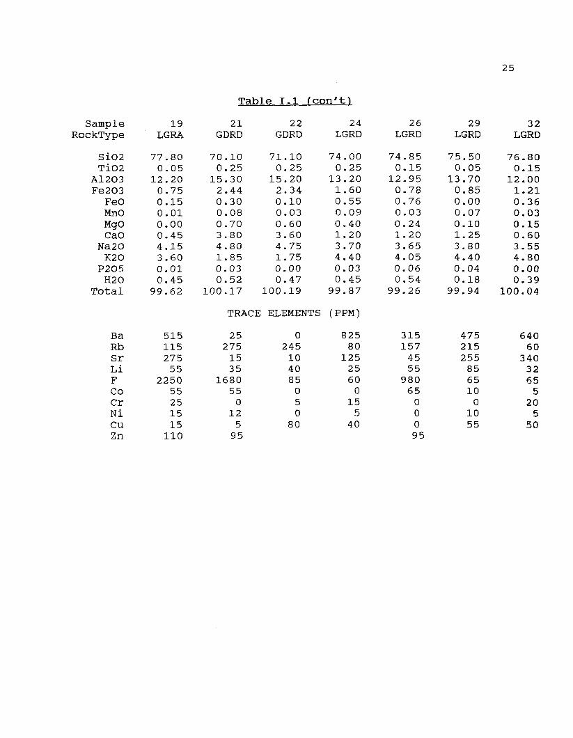
A total of 3 2 chemical analyses of the AVP and 3 9 analyses
of the IMP were carried out during the course of this study. A
representative selection is presented in Tables 1 and 2
respectively. The granodiorite unit of both plutons (that is,
granodiorite and related rocks) exhibit a range of SiO2 values,
varying from 66% to 68% in the case of the IMP and 69.7% to
7 2.1% for the AVP. The leucogranite unit of the AVP features
SiO2 values ranging from 73.8% - 77.8% whereas the same unit of
the IMP has SiO2 values ranging from 70% to 77%. Both plutons
are intruded by fine-grained leucogranite dykes which have SiO2
concentrations greater than 70%.
The AVP and IMP are mildly peraluminous and metaluminous
respectively. The average value for the peraluminous index for

24
SampleRockType
SiO2TiO2
A12O3Fe2O3
FeOMnOMgOCaO
Na2OK2O
P2O5H2O
Total
CHEMICAL
1GDRT
69.700.45
15.101.781.670.020.112.204.104.150.100.57
99.95
ANALYSES OF
6GDRT
71.150.55
15.001.371.500.130.121.854.153.800.020.72
100.36
Table I .1
THE ARROYO DE LA
8GDRT
71.200.50
14.901.481.370.060.061.904.153.950.020.32
99.91
10GDRT
72.150.50
14.501.371.300.080.071.804.103.750.020.67
100.31
VIRGEN
12LGRA
73.800.30
13.801.230.790.050.031.003.854.300.070.27
99.49
PLUTON
14LGRA
75.200.40
13.001.300.500.010.000.604.154.300.010.40
99.87
16LGRA
75.700.05
13.800.800.000.020.001.203.654.300.030.29
99.84
TRACE ELEMENTS (PPM)
BaRbSrLiFCOCrNiCuZn
705270385105
604510
050
73090
2052035
015
555
315194145
7285
50
1590
275180215
562250
95251520
100
195145
383556
000
78
490145315
452240
6515
0595
485185225
786510
05
25
25
T.l fcon't)
SampleRockType
SiO2TiO2
A12O3Fe2O3
FeOMnOMgOCaO
Na20K20
P2O5H20
Total
19LGRA
77.800.05
12.200.750.150.010.000.454.153.600.010.45
99.62
21GDRD
70.100.25
15.302.440.300.080.703.804.801.850.030.52
100.17
22GDRD
71.100.25
15.202.340.100.030.603.604.751.750.000.47
100.19
24LGRD
74.000.25
13.201.600.550.090.401.203.704.400.030.45
99.87
26LGRD
74.850.15
12.950.780.760.030.241.203.654.050.060.54
99.26
29LGRD
75.500.05
13.700.850.000.070.101.253.804.400.040.18
99.94
32LGRD
76.800.15
12.001.210.360.030.150.603.554.800.000.39
100.04
TRACE ELEMENTS (PPM)
BaRbSrLiFCoCrNiCuZn
515115275
552250
55251515
110
25275
1535
168055
012
595
0245
104085
050
80
82580
1252560
015
540
315157
4555
98065
00095
475215255
856510
01055
64060
3403265
520
550

26
Table 1.2
SampleRocktype
SiO2TiO2
A12O3Fe2O3
FeOMnOMgOCaO
Na20K20
P2O5H2O
Total
CHEMICAL ANALYSES OF THE
1GDRT
66.000.50
15.901.151.950.052.503.953.752.950.100.30
99.10
2GDRT
66.600.90
15.901.353.700.162.004.604.451.800.300.12
101.88
3GDRT
67.000.85
15.851.303.650.151.904.504.401.750.250.20
101.80
ISLA MALA
4GDRT
67.300.50
14.102.702.200.102.103.553.352.950.150.25
99.25
PLUTON
5GDRT
67.400.90
13.703.960.220.061.852.703.204.500.000.69
99.18
6GDRT
67.700.80
15.801.253.550.101.804.404.401.700.200.10
101.80
7GDRT
68.000.50
14.902.252.390.401.002.804.203.500.150.16
100.25
500
TRACE ELEMENT (PPM)
750 830 620 850 600 1120

27
Table 1.2 fcon't.)
8LGRA
71.100.35
15.100.880.750.100.502.404.803.200.010.76
99.95
16LGRA
73.000.10
15.001.070.580.050.401.905.003.000.050.58
100.73
17LGRA
73.500.15
15.000.881.010.070.402.104.802.000.500.28
100.69
20LGRA
76.000.00
13.500.750.150.100.001.104.303.800.000.16
99.86
21LGRA
76.600.30
11.801.080.290.010.120.742.905.100.010.51
99.46
22LGRA
76.900.20
11.700.820.430.020.110.743.204.800.010.31
99.24
23HORN
55.400.80
11.804.033.480.159.00
10.702.500.800.200.92
99.78
28DIOD
62.800.80
15.503.772.460.152.904.703.602.800.200.42
100.10
860
TRACE ELEMENT (PPM)
350 200 900 585 660 880
28
Table 1.2 fcon'ti
30DIOD
63.401.00
15.252.503.550.103.205.203.352.700.250.40
100.90
33LGRD
70.200.70
14.203.301.450.100.501.804.154.000.150.15
100.70
34LGRD
70.500.40
14.302.701.160.100.451.503.754.050.100.27
99.28
37LGRD
75.000.00
13.800.850.250.050.101.204.403.900.000.20
99.75
38LGRD
75.900.01
12.301.000.360.020.050.573.205.300.000.36
99.07
39LGRD
77.700.40
12.700.010.020.010.140.503.004.850.010.61
99.95
TRACE ELEMENT (PPM)
1000 930 900 420 1680 815

29
19 analyses of the plutonic component of the AVP and 13
analyses of the late dykes is 1.01 in both cases. The same
index for 22 plutonic analyses of the IMP and for 14 analyses
of the related dykes is 0.97 and 0.93 respectively.
Analyses of both plutons plot within the calc-alkaline domain
on an igneous AFM plot as defined by Irvine and Baragar (1971),
(Figures 1.4a and 1.4b). Two trends are seen on Figure 1.4a,
one defined by the dykes and the other by the plutonic host
rocks. No such discrimination between dykes and host is obvious
on Figure 1.4b. The same two trends for the AV suite are
apparent on an MgO - SiO2 plot (Figure 1.5a). The dyke suite is
distinctly more magnesian than is the plutonic host at
intermediate SiO2 values. The dykes also have higher XFe
(Fe*O/(Fe*O + MgO)) and possible slightly lower TiO2 values.
Fluorine is bimodally distributed in the AVP. Of the 31
analyses available, 21 have F values less than 100 ppm, whereas
the F concentrations surpass 1000 ppm (up to 2 300 ppm) in the
other 10 analyses. No analysis show values between 100 ppm and
1000 ppm. Both the pluton and the dykes have low as well as
high F values. In contrast, the F distribution in the IMP is
unimodal. The F values in the 20 available analyses are all
greater than 100 ppm and only two of these surpass 1000 ppm.
30
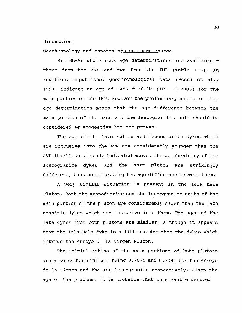
Discussion
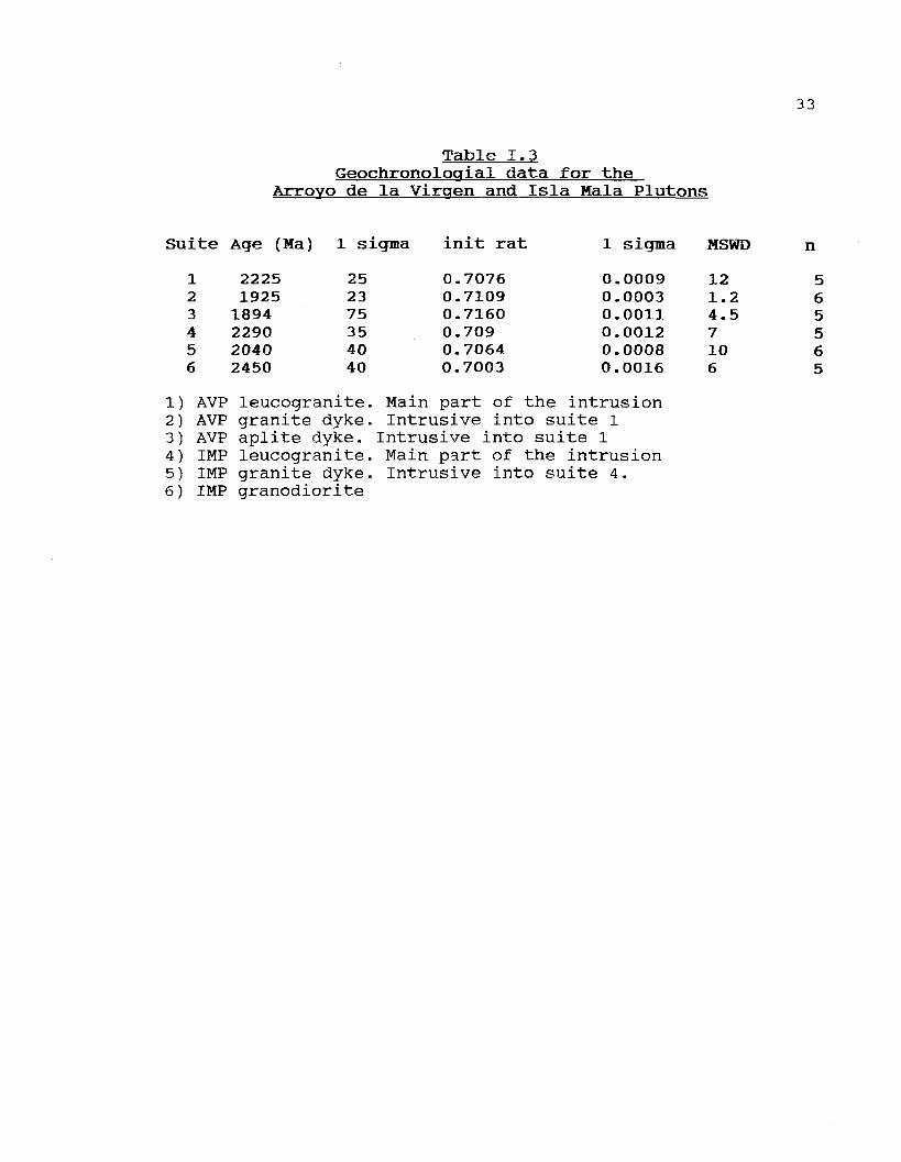
Geochronology and constraints on macrma source
Six Rb-Sr whole rock age determinations are available -
three from the AVP and two from the IMP (Table 1.3). In
addition, unpublished geochronological data (Bossi et al.,
1993) indicate an age of 2450 ± 40 Ma ( IR = 0.7003) for the
main portion of the IMP. However the preliminary nature of this
age determination means that the age difference between the
main portion of the mass and the leucogranitic unit should be
considered as suggestive but not proven.
The age of the late aplite and leucogranite dykes which
are intrusive into the AVP are considerably younger than the
AVP itself. As already indicated above, the geochemistry of the
leucogranite dykes and the host pluton are strikingly
different, thus corroborating the age difference between them.
A very similar situation is present in the Isla Mala
Pluton. Both the granodiorite and the leucogranite units of the
main portion of the pluton are considerably older than the late
granitic dykes which are intrusive into them. The ages of the
late dykes from both plutons are similar, although it appears
that the Isla Mala dyke is a little older than the dykes which
intrude the Arroyo de la Virgen Pluton.
The initial ratios of the main portions of both plutons
are also rather similar, being 0.7076 and 0.7091 for the Arroyo
de la Virgen and the IMP leucogranite respectively. Given the
age of the plutons, it is probable that pure mantle derived

31
Xiroyo de la Yirgen
Imne i Barapr 1971 (fig 2)
reo*
ïa20 + 120
M a Ha la
[mue & Baragar 1971 (fig 2)
FeO*
ïa20 t 120
Figure 1.4) AFM diagram for the AVP (4a) and the IMP (4b).Limit between calc-alkaline and tholeiitic fields taken fromIrvine and Baragar (1971). Legend for figure 4a: * = lategranitic dykes; o = granodiorite and leucogranite. Legend forfigure 4b: * = late dykes; o = main unit of complex; triangle -hornblendite

32
de la Tligen
65 66.5 71 72.55102
Isla Dala12
62 65SiO2
Figure 1.5) MgO - SiO2 plot for the ÀVP (5a) and the IMP (5b).Symbols as on Figure 1.4.
33
Table 1.3Geochronologial data for the
Arroyo de la Virqen and Isla Mala Plutons
it«
l23456
î Age (Ma)
22251925
1894229020402450
1 sigma
252375354040
init rat
0.70760.71090.71600.7090.70640.7003
1 sigma
0.00090.00030.00110.00120.00080.0016
MSWD
121.24.57106
n
565565
1) AVP leucogranite. Main part of the intrusion2) AVP granite dyke- Intrusive into suite 13) AVP aplite dyke. Intrusive into suite 14) IMP leucogranite. Main part of the intrusion5) IMP granite dyke. Intrusive into suite 4.6) IMP granodiorite

34
melts would have had an initial ratio of approximately 0.7018
(Cox et al., 1979, page 364). Thus the higher initial ratio for
these rocks suggests either substantial contamination of a
mantle melt by a crustal component, or possibly that the melts
are totally of crustal origin.
Similar comments pertain to the dykes, however the
elevated initial ratio of the aplite dyke intrusive into the
AVP makes it relatively certain that it contains a large
proportion of upper crustal component.
Depth of Emplacement
Several indirect lines of evidence all indicate a shallow
to moderate depth of crystallization for most of the plutonic
units. The presence of andalusite in the IMP contact aureole of
the leucogranite unit of the IMP shows that the pressure of
emplacement was less than that of the triple point in the
aluminosilicate system (approximately 3.8 kb in the pure system
- Holdaway, 1971). The presence of perthite is also suggestive
of low water pressures (see Martin and Bonin, 1976) however
there is no pétrographie evidence in the form of abundant
pegmatites or miariolitic cavities to indicate fluid saturation
during the crystallization of even the most evolved members of
either pluton. Third, a plot of the most evolved samples from
each mass (those with a normative quartz + albite + orthoclase
greater than 95% in Figure 1.6 can be compared to experimental
data for minimum melt compositions in the haplogranitic system.

35
The trajectory of minimum melt compositions in water saturated
systems is a function of total pressure which is shown on
Figure 1.6 along with data points for each pluton. The data
points fall slightly to the right of the minimum melt
trajectory - which may be due to the small amounts of CaO
present in the magma or to C02 (Ebadi and Johannes, 1991) or
both. Extrapolating to the left generates an intersection of
approximately 2 and 0.5 kb for the AVP and the leucogranite
unit of the IMP respectively. Since water saturation cannot be
demonstrated to have been attained during the crystallization
of either pluton, these values represent the minimum pressure
of emplacement.
Chemical Classification of the Tectonic setting
A number of tectonic discriminant diagrams have been
proposed in recent years. Application of these diagrams is
somewhat confusing since there is no accepted terminology for
the environments in which granitic rocks may develop.
Furthermore, the discriminant functions which have been
proposed are based on different data bases and use different
elements to effect the discrimination. The comments which
follow must therefore be viewed with some caution.
Maniar and Piccoli (1989) proposed a method based
exclusively on major element data. Application of this approach
suggests a major difference in the tectonic setting of
emplacement of the two plutons. Figures I.7a and I.7b are

36
QUARTZ
Arroyo de la Virgen pluton
o Arroyo de la Virgen dykes
x Isla Mala pluton and dyke
1/2 X X
V V V V V V
ALBITE ORTHOCLASE
Figure 1.6) Normative quartz - albite - orthociase diagram forthe most evolved plutonic analyses from the AVP. Location ofminimum melt compositions taken from Winkler (1979).

37
FeO*/FeO* + MgO versus SiO2 plots for the ÀVP and the IMP. The
main portion of the AVP (Figure I.7a) falls in the CEUG/RRG
domain on this plot whereas the late dyke suite falls into the
IAG/CAG/CCG/POG domain. In fact, the most chemically evolved
members of both the main portion of the pluton as well as the
dyke suite fall very close to one another on this plot. Only
the intermediate members of either suite (less than 71% SiO2),
can be successfully discriminated. An attempt to classify the
main portion of the AVP as either CEUG or RRG using a TiO2 -
SiO2 plot, as advocated by Maniar and Piccoli, was not
successful. The same two groupings are apparent on Figure I.5a
- the main portion of the AVP defines a trend featuring low MgO
values.
Figure I.7b shows that both the IMP as well as the related
dyke suite are most probably IAG, CAG, POG or CCG type plutons.
The data points for all rock types define a broad band which
crosses the central portion of the diagram. The low value for
the peraluminous index of the pluton (less than 1.0) enables
the CCG environment to be eliminated from consideration,
however it is not possible to distinguish between the IAG, POG
and CAG environments.
The above distinctions are also obtained using the method
of Batchelor and Bowden (1985) who used the R1-R2 diagram
(Figures I.8a and I.8b) of LaRoche et al. (1980) as a tectonic
discriminant diagram. Data points for the AVP appear to define
a trend which originates in the late-orogenic (sub-alkaline)

a) Ar royo ce 3 l ' i roen '.teniar S Pi ceo 11 1939 [ f i g 10c)
55 70SiO2 [ w t 80
eo
38
b)
s?"S
Io9
i
is!a Va la
g
E
50
Pluton
RPG+CEUG
�
A
A
kteniar
o
G
-
65
i PlCCOl i
_ - � - �0
o o
A °
o
5iO2
19B9
��-
.
o
(wt
Cfig
o
�y�
70
10c]
o
O
� -~a
�a D
�o
_ _ � � �
D
^ /
75
/
POG
-
80
Figure 1.7) FeO*/(FeO* + MgO) - SiO2 plot for the AVP (7a) andthe IMP (7b).circles = granodiorite and related rocks; squaresleucogranite; triangle = hornblendite and/or diorite; plus sign= granodiorite dyke; diamond = leucogranite dyke.CEUG (continental epeirogenic uplift granite); RRG (riftrelated granite); IAG (island arc granite); CAG (continentalarc granite); CCG (continental collision granite); POG (postorogenic granite).
39
field. The fact that the data points indeed define a trend
which originates in one of the fields numbered 1 to 5 argues
against the possibility that these rocks are syn-collisional in
nature. The trend for the AV dykes, as well as for both the IM
dykes and pluton define trends that are largely in the pre-
plate collision field which includes destructive plate margins
such as the Cordillera.
Implications for Tectonic History
The geochronological data clearly reveal the presence of
two, and possibly three, groups of granitoid plutons in
southern Uruguay. (1) the main portion of the IMP (2450 Ma -
Bossi et al., 1993); (2) the leucogranitic unit of the IMP and
the AVP (2290 Ma and 2225 Ma respectively - see Table 1.3); (3)
the late dykes intrusive into both complexes (roughly from 1900
Ma to 2000 Ma - Table 1.3).
None of these plutonic rocks appears to have been
metamorphosed, although all have been altered, particularly the
main portion of the IMP. We conclude, therefore, that the
metamorphic event which developed the 'greenschist facies
assemblages in the Paso Severino Formation and the upper
amphibolite to granulite facies assemblages in the gneisses is
definitely older than 2290 Ma and possibly older than 2450 Ma -
that is, the regional metamorphism is likely of Archean age.
This tentative conclusion is in agreement with Cordani et al.,
(1988) who suggested that almost all of the continental crustal

40
material in this portion of Uruguay formed prior to 2500 Ma. It
is possible that the main portion of the IMP formed near the
end of this deformational event, and therefore escaped the most
intense periods of the metamorphism, however there is no
independent evidence to support this hypothesis. The IMP
leucogranite and the AVP are both considerably younger than the
main portion of the IMP. The IMP leucogranite is the older, and
features a chemistry suggestive of a pre-plate collision/active
continental margin type of tectonic environment. The AVP is
slightly younger and has a chemistry suggestive of a late-
orogenic environment.
Soliani (1986) dated a granitic body located in northern
Uruguay which is located within one of the fault zones. The age
of this granite (2263 Ma) corresponds to the age of fault
development. Thus it is possible that the period 2 290 Ma to
2225 Ma (data Table 1.3) records a major deformational event,
during which time significant differential movement occurred.
Previously metamorphosed low grade and high grade rocks were
tectonically juxtaposed, the contact between these zones being
occupied by mylonitic rocks. We associate this period of
tectonic activity and associated plutonism with the
Transamazonian orogeny. Similar abrupt metamorphic transitions
were noted in the Superior Province of the Canadian Shield by
Card (1990) who suggested that this might be the result of the
assembly of "suspect terranes" such as those of the North
American Cordillera (see Coney et al., 1980; Gabrielse, 1991).

41
a) Arroyo ce la Virgen2500; '-T-
Batchelor & Bowden 1985 [fig 10)
20GG[-
1 - Mantle Fract ionates2 - Pre-plate Col 1151 en3 - P o s t - c o l l i s i o n l ( 5 l i f t4 - Late-orogenic5 - Anorogenic6 - Syn-colI is ion7 - Pcst-orogenic
500 1DD0 1500R1 = 4Si - 11[Na + Q - 2(Fe * T i )
2000 2500 3000 3250
b) Isia Mala Pluton Batchelor & Bowden 1985 (fig 10)2500; , , , ,
� 1 - Mantle Fract ionates| 2 - Pre-plate Col I is ion
2000J- 3 - Pos t - co l l i s i on 1(5 l i f t| 4 - Late-orogenic! 5 - Anorogenicj 5 - Syn-col l is ion
150DJ� ' 7 - Post-orogenic
0 500 1000 1500R1 = 4Si - 11[Na 4 q - 2(Fe + Ti )
2000 2500 3000 3250
Figure 1.8) Tectonic discriminant diagram for the AVP (8a) andthe IMP (8b). Diagram based on the method of Batchelor andBowden (1985). Symbols as on Figure 1.7.

42
Thus it is reasonable to propose, as a working hypothesis,
that a period of tectonic subduction occurred between 2290 Ma
(pre-collision phase) and 2225 Ma (post-collision phase) which
brought previously metamorphosed, possibly Archean rocks into
contact with one another. If the subduction were oblique,
significant horizontal (as well as vertical) displacements may
have occurred, and the crust may have been fragmented into a
number of lens-shaped lithotectonic blocks of different
metamorphic grade (Sylvester, 1988). We consider this event to
be the main phase of the Transamazonian orogeny in southern
Uruguay.
The late dykes feature a chemistry which once again is
typically calc-alkaline. Although these dykes are
volumetrically insignificant, the dates obtained from these
dykes are similar to that reported for the Mahoma Pluton, which
is located 50 km to the west and which has been dated at 1979
± 35 (Rb-Sr whole rock - recalculated from data of Umpierre and
Halpern, 1971). Thus there is reason to believe that the period
of roughly 1900 Ma to 2000 Ma was also a period of significant
plutonic activity in the region. We are not certain how these
relatively young plutonic rocks are related to the
Transamazonian orogeny, and until a detailed geochemical study
of the Mahoma Pluton, or another pluton of similar age, is
carried out, we can only speculate that the Transamazonian was
a poly-deformational event and that these plutons were formed
during the terminal stages of this orogenic episode.

43
Conclusions
1) Age data reveal the presence of two or possibly three groups
of intrusive rocks in southern Uruguay (2450 Ma; 2290 Ma to
2225 Ma; and 1894 Ma to 2040 Ma respectively - data from Bossi
et al., 1993; Preciozzi (1990) and Table 1.3 of this work).
2) The leucogranitic unit of the IMP (2290 Ma) has not been
metamorphosed and has imposed an andalusite-bearing contact
aureole on the schists of the Paso Severino Formation, thus
demonstrating that the Paso Severino is of still older,
possible Archean age.
3) The leucogranitic unit of the IMP appears to have formed in
a pre-plate collision/continental margin type of environment
whereas the slightly younger AVP (2225 Ma) features a chemistry
suggestive of a late-orogenic environment. Hence the period
from 2290 Ma to 2225 Ma may correspond to the period during
which time a number of discrete lithologie blocks were
tectonically assembled to form this portion of the Brazilian
Shield. We believe that this event represents the main phase of
the Transamazonian orogeny in southern Uruguay.

44
CHAPTER II
GEOCHEMISTRY AND GEOCHRONOLOGY OFTHREE PLUTONS FROM CENTRAL URUGUAY:
TECTONIC IMPLICATIONS FOR THE TRANSAMAZONIAN OROGENY

45
Introduction to Chapter 2
The Arroyo Grande Belt is the smallest of the three
metamorphic belts recognized in south-central Uruguay and is
located along the northern margin of the Piedra Alta Terrane.
Geological mapping has suggested a striking similarity between
the rocks of this belt and those found in the San José Belt to
the south, both in terms of structural development and the
metamorphic grade of the rocks. However these two belts are
separated from one another by an east-west trending band of
gneissic rocks of considerable width. Thus is was not sure to
what extent the observed similarities between the two
metamorphic belt might by superficial and coincidental.
As in the case of the San José Belt, the Arroyo Grande Belt
has also acted as host to a number of granitoid intrusions.
Thus, to further examine the similarities (or possible
differences) between the San José and the Arroyo Grande
metamorphic belts, it was deemed useful to carry out a
geochemical and geochronological study of the Arroyo Grande
Belt granitoids in order to compare them to the San José
granitoids described in chapter 1. The results of this study,
the comparison with the San José granitoids, and the tectonic
implications of the results, are presented as chapter 2.

46
Introduction
From a geotectonic standpoint, Uruguay is a part of the
South American Platform which became tectonically stable at the
end of the Proterozoic era. This vast area consists of a number
of cratonic regions which became stable at the end of the
Transamazonian Cycle, separated by a number of fold belts of
different ages.
The very few radiometric dates available enable the
Precambrian rocks of Uruguay to be subdivided into a number of
different age groupings as follows:
pre-Transamazonian rocks <2200 Ma
Transamazonian rocks 2200 - 2000 Ma
post-Transamazonian rocks 1900 - 1700 Ma
pre-Brazilian rocks 1400 - 1000 Ma
Brazilian rocks 1000 - 500 Ma
The Transamazonian rocks can be subdivided into two main
groupings: a) upper amphibolite to granulite faciès metamorphic
rocks including large areas of granitic rocks and gneissic
granites, b) either greenschist faciès (Minas de Corrales,
(Preciozzi et al., 1985), Paso Severino, Cerros de San Juan and
Arroyo Grande Formations) or amphibolite faciès (San José and
Montevideo Formations) rocks which are found as thin bands
intercalated with the granitic gneiss complex.
The Arroyo Grande Formation (AGF) (Ferrando and Fernandez,
1971; Fernandez and Preciozzi, 1974; Preciozzi et al., 1979) is
located along the northwestern margin of the Uruguay

47
Crystalline Terrane (Figure II.1), which forms the basement to
the Rio de la Plata Basin. The AGF has been intruded by a
number of bodies of granitic rocks, three of which are the
Marincho Complex (MC), the South Granite (SG) and the Arroyo
Grande Pluton (AGP). The purpose of this article is to present
pétrographie, geochronologic and whole rock geochemical data
for these three intrusive suites and to discuss the
implications of these findings for the Proterozoic evolution of
this portion of the South American Platform. A detailed
microprobe study of the minerals present in the MC has been
presented elsewhere (Preciozzi 1989c).
Geological Setting
The AGF consists of greenschist facies metasedimentary and
metavolcanic rocks which are exposed in a lozenge-shaped area
approximately 40 km in length with a maximum width of 13 km.
Detrital metasedimentary rocks (with minor metavolcanic units)
constitute the lower and middle sections of the formation and
are exposed along the northern and central portions of the
outcrop area of the AGF, (Figure II.2). The metavolcanic rocks,
the uppermost portion of the AGF, are exposed along the
southern margin of the lozenge. Both rock types typically have
an overall east-west strike except near the margins of the
granites where the schistosity tends to be oriented parallel to
the contact of the intrusion. The Paso de Lugo fault, a major

48
30°S ��
35°S
Mesozoic and Cenozoic rocks(excluding Arapey Formation)
Arapey Formation (tholeiitic basalts)
Permian-Carboniferous rocks
Rocks deformed during Transamazonian event
Rio de la Plata Craton
Nico Perez terrane
Rocks deformedduring Brazilian event
Transamazoniangranitoid intrusion
Mylonite zone
Fault
Limit ofPrecambrian rocks
Figure II.1) Geological sketch map of Uruguay showing thelocation of the study area, central Uruguay.

49
structure of considerable linear continuity and east-west
orientation, forms the southern boundary of the lozenge,
separating it from granitic gneisses and related granitic rocks
to the south. The Paso del Puerto fault forms the northwestern
boundary of the AGF - the boundary has not been studied in
detail in the northeast. It is likely that the whole of the AGF
is fault-bounded since the metamorphic grade increases suddenly
from greenschist facies to upper amphibolite faciès once these
faults are crossed. A similar feature has been noted in the
Canadian Shield by Card (1990) who suggested that the fault
bounded nature of the contacts and the metamorphic
discontinuity might be explained by an accreted assemblage of
different tectonic terranes.
Six different granitic bodies have been intruded into the
AGF, the largest of which are the MC and the SG (50 km2 total
for both plutons) and the AGP (20 km2). Of the remaining three
plutons, the Yi and Feliciano granites feature well developed
planar structures indicating that they have been deformed. The
observed foliation in these two plutons appears to correspond
to the Dl structures present in the surrounding AGF. We
therefore consider these plutons to be syn-tectonic in
character with respect to the first major episode of
deformation.
It is probable that the Feliciano mass is older than the Yi
since the Feliciano has been intruded by a swarm of acid dykes
which have not been observed to cross-cut the Yi Pluton. The

50
DEVONIAN TO CRETACEOUS
|-'��'�'/'\-| Sedimentary cover
EARLY PROTEROZOIC
Marincho Complex
10 km
� Hornblendite
O I Associated granodiorite
Granodiorites of the main unit
x I Leucogranite
Arroyo Grande granodiorite
South granite
Altered granodiorite
Arroyo Grande Formation
|~I_| Metasedimentary rocks
Metavolcanic rocks
Southern granitoid complex
Carpinteria leucogranite
Paso del Puerto granitoids
Late granitic dykes
Figure II. 2) Sketch map of the local geology showing thelocations of the Marincho Complex, the South Granite and theArroyo Grande Granodiorite. Location of sketch map is shown onFigure II.1. After Preciozzi (1989c).
51
Carpinteria Pluton is a very small mass of garnetiferous, two-
mica leucogranite which is located to the east of the Marincho
Complex (Figure II.2). None of these three plutons will be
considered further in this report.
Petrography
Marincho Complex
The MC is a crudely circular mass, approximately 8 km in
diameter which is located in the centre of the AGF. It is a
composite pluton consisting of three distinctly different
components :
a) the main unit. which consists typically of grey, biotite-
hornblende granodiorite, but which ranges in composition from
diorite to monzogranite. Both the texture and mineralogy vary
rather noticeably from outcrop to outcrop. Plagioclase
compositions range from An42 in the diorite to Anl9 in the
monzogranite. Plagioclase in the more mafic members of the unit
are often altered to epidote and sericite. The potassium
feldspar is a perthitic microcline. Myrmekitic intergrowths are
frequently observed at the contacts between plagioclase and
potassium feldspar. The quartz crystals typically have
undulatory extinction. The amphibole is a green hornblende
typical of intermediate plutonic rocks (Deer et al., 1966).
Biotite contains numerous inclusions of zircon, apatite,
titanite and opaque minerals and is spatially associated with
hornblende.

52
The main unit contains enclaves of fine-grained basic
material as well as xenoliths derived from the surrounding AGF.
The rock is typically massive and there is no evidence of an
igneous foliation being present.
b) the hornblendite and associated granodiorite forms a NE
trending band which crosses the centre of the complex, with
rocks of the main unit being located both to the west and to
the east. The hornblendite is typically a porphyritic rock
containing coarse-grained, euhedral dark green hornblende and
also medium-grained subhedral pale green hornblende.
Clinopyroxene is present, either as independent grains or as
relicts surrounded by the dark green hornblende. A
concentration of opaque minerals is frequently observed at the
contact between the relict clinopyroxene and the amphibole.
Plagioclase compositions vary from An52 - An56. The plagioclase
is typically altered to a fine-grained assemblage of pistachite
(pleochroic yellow epidote) and clinozoisite.
A "granodioritic" unit, whose composition ranges from
diorite to monzogranite, is intimately associated with the
hornblendite. Although superficially similar to the main unit
granodiorite, Fernandez and Preciozzi (1974) observed that the
plagioclase compositions are systematically more sodic in the
main unit granodiorites. The plagioclase compositions vary from
An52 in the dioritic members of this unit to An25 in the
monzogranitic members. The mineralogy and textures exhibited by
this unit are comparable to those observed in main unit rocks.

53
The rocks of this unit clearly are intrusive into the rocks
of the main unit described above. A well developed igneous
foliation, defined by aligned hornblende crystals, is present
near the contact with the rocks of the main unit.
c) a leucogranite unit forms a mappable mass of irregular form
in the east central portion of the complex. It is completely
surrounded by main unit rocks and appears to be intrusive into
it. The plagioclase is zoned and varies in composition from An8
in the core of the crystals to An2 at the margin. The potassium
feldspar is a perthitic microcline and the quartz features
undulatory extinction. Biotite, generally associated with
muscovite, is the main mafic mineral present. The accessory
minerals include garnet, prismatic apatite and bypyramidal
zircon. Small pegmatitic segregations were observed in the
field which suggests that this particular unit of the MC was
fluid saturated during crystallization.
d) a set of leucogranite dykes featuring hypidiomorphic
granular textures. They are intrusive into the eastern portion
of the MC (leucogranitic member as well as the main unit). They
contain oligoclase, perthitic microcline and quartz as the main
minerals. The principal accessory minerals are biotite, garnet
(relatively abundant), zircon, sphene, apatite and opaque
minerals.
54
The South Granite fSGI
The SG, which is located immediately adjacent to the MC,
features massive, granitic to porphyritic textures except at
the contact between either the AGF or the rocks of the main
unit where cataclastic to mylonitic textures are observed.
Biotite forms irregular crystals which have been partially
replaced by chlorite. Potassium feldspar is a perthitic
microcline and the plagioclase is sodic oligoclase in
composition. Quartz crystals typically feature undulatory
extinction and have mortar texture developed along intergrain
contacts. Enclaves and xenoliths of the surrounding rock types
are notably absent.
Arroyo Grande Pluton (AGP1
The AGP exhibits a much more restricted pétrographie range
than does the MC, varying in composition from granodiorite to
monzogranite. Biotite is deep brown in colour and is spatially
associated with hornblende. The plagioclase composition varies
from An32 in the granodiorite to Anl6 in the monzogranite. The
potassium feldspar is a perthitic microcline.
The pluton is somewhat elongate in form and appears to be
spatially related to the Paso del Puerto Fault.
56
The difference in both the ages, and to a lesser extent the
initial ratios, suggest that all these rocks should be
considered to have evolved relatively independently of one
another.
The data for the granitic blocks found within the Paso de
Lugo Fault Zone (2544 ± 38 Ma; initial ratio 0.7073)
demonstrate the presence of Archean crust in the area at this
time. Furthermore, the initial ratio is rather high, and
therefore it is reasonable to propose that crustal material was
incorporated in the magma at some point. This crustal material
must obviously have been older than the age of the granitic
blocks. Another late Archean age determination on blocks in a
similar tectonic setting has been reported by Preciozzi (1992)
(2501 ± 112 Ma; initial ratio 0.7003). In this latter case, the
low initial ratio suggests that the primary magma was derived
by partial melting of previously depleted mantle material
(previously melted between 2800 and 3000 Ma?).

57
Table II.1
RESULTS OF RADIOMETRIC AGE DETERMINATIONS FOR THEMARINCHO COMPLEX fMCLÏ AND THE SOUTH GRANITE fSG) SUITES
Suite Rb87/Sr86 1 sigma Sr87/Sr86 1 sigma age
MCL-1MCL-2MCL-3MCL-4MCL-5MCL-6MCL-7
LGR-1LGR-2LGR-3LGR-4LGR-5
GRS-1GRS-2GRS-3GRS-4GRS-5
GDP-1GDP-2GDP-3GDP-4GDP-5GDP-6
BGR-1BGR-2BGR-3BGR-4BGR-5BGR-6
2.9072.7091.4571.7252.0821.8091.302
0.5120.6230.7511.7563.532
0.4960.8021.5962.2502.489
0.2730.3870.6110.7671.9652.026
0.2510.3740.5011.1261.6552.887
0.00270.00560.00210.00120.00270.00360.0052
0.00210.00170.00240.00160.0033
0.00320.00120.00240.00150.0021
0.00250.00130.00180.00270.00330.0012
0.00150.00220.00310.00110.00140.0017
0.819950.814360.780170.784210.797250.788710.77391
0.735050.736010.740080.771520.82561
0.726570.733650.758010.778540.78851
0.720170.726310.735120.740070.778140.78024
0.716050.719600.725170.750080.766510.81350
0.000120.000110.000260.000190.000320.000130.00007
0.000210.000310.000220.000110.00013
0.000260.000090.000320.000110.00015
0.000170.000270.000110.000410.000230.00017
0.000210.000190.000430.000100.000170.00009
1969
MSWD
IR =
2067
MSWD
IR =
2180
MSWD
IR =
2291
MSWD
IR =
2544
MSWD
IR =
±
=
0.
+
=
0.
+
=
0.
+
=
0.
+
=
0.
25 Ma
26
734
24 Ma
28
719
50 Ma
76
709
65 Ma
73
714
38 Ma
76
7073
Data from Preciozzi (1992).MCL: late leucogranite dykes cross-cutting the Marincho ComplexLGR: leucogranite unit of the Marincho ComplexGRS: South GraniteGDP: Main portion of the Marincho ComplexBGR: Granite blocks located within the Paso de Lugo Fault Zone
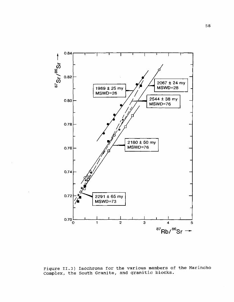
58
0.84
COCOoo
CO00
0.82
0.80
0.78
0.76
0.74
0.72
0.700
1969 ± 25 myMSWD=26
2067 ± 24 myMSWD=28
2544 ± 38 myMSWD=76
2180 ± 50 myMSWD=76
2291 ± 65 myMSWD=73
87Rb/86Sr
Figure II.3) Isochrons for the various members of the MarinchoComplex, the South Granite, and granitic blocks.
59
Geochemi stry
A total of 41 analyses of the MC and 10 of the AGP are
presented in Table II.2.
The validity of the pétrographie terms applied to the
samples of both suites is apparent on the P-Q plots (Figures 4a
and 4b) proposed by Debon and Lefort (1983). The MC suite
defines a broad band of data points which sweeps across the
diagram from the quartz diorite to the syenogranite fields with
the majority of samples falling in the granodiorite or
monzogranite domains. Two trends are crudely apparent on the
diagram, the first defined by the hornblendite and associated
granodiorites as well as the granodioritic rocks of the main
unit. The Q values for these rocks increase from 50 in the
quartz diorites to approximately 150 in the granodiorites and
then decline to 100 in the more evolved granitic rocks. The
second trend is defined by those rocks which were mapped in the
field as "leucogranites" (and related rocks). The data points
for these rocks define a trend parallel to the second part of
the first trend however it is situated at much higher Q values,
which fall from 225 in the granodioritic members of the unit to
180 in the more evolved members. This observation is mirrored
in the normative mineral contents of these two groups of rocks.
The leucogranites have normative quartz contents which decline
from 40% to 3 5% in the more evolved members whereas the rocks
defining the first trend rarely have normative quartz values

Table II.2CHEMICAL ANALYSES OF THE MARINCHO COMPLEX
60
# R SiO2 TiO2 A12O3 Fe2O3 FeO MnO MgO CaO Na2O K2O H2O Total
12345678910111213141516171819202122232425262728293031
AAALLLLLLLHHHHHGGGGGGGGGGGGGGGG
60.0061.9062.0074.6074.9075.0075.0075.0075.3075.6050.1052.2052.8056.7062.0061.9062.9063.0066.0066.5066.5066.5066.8067.1067.3067.5067.5067.8667.9668.7068.96
0.600.600.500.010.010.010.050.050.050.010.850.600.600.500.500.850.800.800.700.600.700.800.700.750.800.550.780.700.700.750.65
17.8017.5017.1014.1013.5013.7013.4013.2013.0012.8012.7010.4011.80
9.0010.0016.5016.3016.2014.8014.5014.3015.6014.6014.5014.7013.5014.6014.6015.3014.3014.30
4.222.984.020.510.490.800.590.950.920.903.834.823.672.792.871.611.411.212.572.402.471.382.472.371.582.601.481.681.581.381.58
5.212.902.010.360.730.010.630.150.080.016.374.495.075.502.823.163.063.261.742.611.842.121.701.541.922.412.021.821.621.821.72
0.180.070.100.090.180.090.120.080.080.080.160.160.160.230.140.120.090.080.040.050.040.100.070.020.100.100.080.050.050.050.05
1.502.301.400.200.150.140.050.300.35
0.2011.0010.7010.6011.30
9.402.452.352.552.302.302.401.402.002.151.502.401.451.551.551.301.45
4.604.704.300.800.900.400.950.500.45
0.6010.0010.9010.4010.707.805.155.054.853.603.403.703.003.443.452.903.302.823.203.302.803.10
4.103.853.804.164.253.754.053.703.85
3.752.452.002.352.202.304.804.704.803.703.603.903.703.753.603.903.753.854.153.853.704.05
1.702.401.552.203.164.703.364.604.50
4.601.101.001.100.702.101.301.201.103.604.103.404.903.403.554.703.954.003.553.203.903.25
0.670.580.381.320.520.620.60.680.65
0.621.142.170.690.860.830.530.510.560.610.580.710.70.250.730.680.780.720.480.470.720.47
100.5899.78
100.1698.3598.7999.2298.8099.2199.23
99.1799.7099.4499.24
100.48100.76
98.3798.3798.4199.66
100.6499.96
100.2099.1899.76
100.08100.84
99.3099.6499.5899.4299.58
Table II.2) Chemical analyses of the Arroyo Grande, South Granite and MarinchoComplex intrusions. Code for Maricho analyses: G = main portion of the MC; L =leucogranite; H = hornblendite; A = associated granodiorite

61
#123456789
10
SiO271.8072.5073.0073.2073.5073.8074.5075.2075.4076.00
TiO20.600.500.200.300.450.400.250.050.010.05
CHEMICALA12O314.8014.6014.7014.7014.3014.4014.4014.2014.0013.80
Fe2O31.381.281.481.381.331.181.180.250.400.30
Table II.2ANALYSES OFFeO
0.850.750.600.650.240.650.450.150.010.10
MnO0.050.100.050.010.010.010.050.010.010.01
(CON'T')THE SOUTH GRANITE
MgO0.720.700.650.600.500.520.500.210.110.05
CaO2.102.052.102.002.001.901.750.300.400.36
Na2O4.053.953.403.754.303.753.603.453.653.60
K2O3.603.503.753.403.203.303.206.105.905.85
H2O0.720.250.420.560.710.520.570.480.360.27
Total100.67100.18100.35100.55100.54100.43100.45100.40100.25100.39
Table I I .2 fCON'Tl
#123456789
10
SiO265.5066.0066.3066.8066.8067.0067.1067.5068.5069.60
TiO20.950.900.850.700.750.800.800.750.550.50
CHEMICAL ANALYSES OF THE ARROYO GRANDE PLUTONA12O315.0014.5014.0013.7013.6013.4013.3013.4014.9015.00
Fe2O31.811.911.531.431.051.201.091.292.542.34
FeO5.945.845.295.395.475.326.056.251.991.59
MnO0.090.140.080.090.150.100.100.210.050.05
MgO1.000.900.800.701.050.900.850.950.930.93
CaO4.054.154.103.953.603.853.553.453.703.50
Na2O3.003.153.003.153.453.303.253.453.753.70
K2O3.002.853.103.252.752.903.903.702.302.20
H2O0.250.270.290.350.480.380.300.450.890.89
Total100.59100.61
99.3499.5199.1599.15
100.29101.40100.10100.30

62
Arroyo Grande Debon & Le Fort 1983400,
L T 3
I I
-200 -100P = I - (Ka t Ca)
Figure II.4a) P-Q classification diagram for the Arroyo GrandePluton. Diagram after Debon and Lefort (1983). 1 =syenogranite; 2 = monzogranite; 3 = granodiorite; 4 = tonalité;8 = quartz diorite;
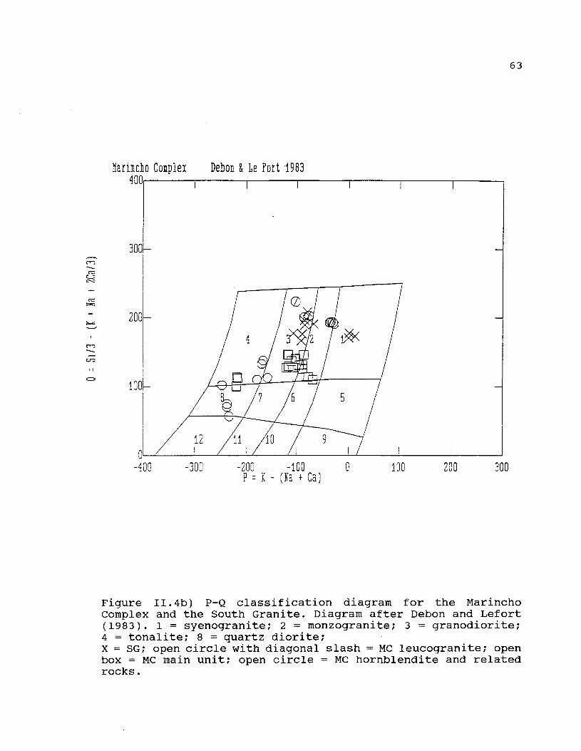
63
tiarincîio Coiplei Debon & Le Fort 1983400
-300P =
. -100- ( ïa + Ca
100 200 300
Figure II.4b) P-Q classification diagram for the MarinchoComplex and the South Granite. Diagram after Debon and Lefort(1983). 1 = syenogranite; 2 = monzogranite; 3 = granodiorite;4 = tonalité; 8 = quartz diorite;X = SG; open circle with diagonal slash = MC leucogranite; openbox = MC main unit; open circle = MC hornblendite and relatedrocks.

64
which surpass 25%. The SG rocks define a crudely triangular
area on Figure II. 4a and no trend is apparent. In common with
the leucogranites, the SG is also characterized by relatively
high Q values.
The AGP exhibits a much more restricted compositional
variability and is largely confined to the granodiorite field.
The trend defined by the data points is parallel to that
defined by the granodiorites of the main unit of the MC.
Both the AGP and the main unit of the MC are metaluminous
intrusive rocks which show very little variation in the
peraluminous index, (PI = A/CNK = 0.90 in both cases). All but
two of the 26 analyses for these two groups of rocks have
values less than 0.95 and all have values less than 1.01. The
SG is mildly peraluminous - PI ranges from 1.03 to 1.15 and
increases with increasing SiO2. The leucogranitic unit of the
MC is considerably more peraluminous - PI values range from
1.04 to 1.32 and decline with increasing SiO2. The high PI
values are related to relatively low K20 contents in some of
the leucogranites.
The MC suite of rocks appears to collectively define a
typical calc-alkaline trend on the igneous AFM diagram of
Irvine and Baragar (1971, Figure II.5b). All but two samples
are either within or very close to the line separating the
calc-alkaline and tholeiitic domains. Data for the AGP define
a trend which straddles the tholeiitic and calc-alkaline
fields.

65
Discussion
al Pressure of Emplacement
Experimental studies in the water saturated haplogranitic
quartz - albite - orthoclase system can be used to estimate the
pressure of emplacement of granitic plutons since the position
of the experimental minimum in this system varies as a function
of pressure. Only the most evolved compositions can be used in
order to reduce uncertainty due to the presence of Ca in
plagioclase. In addition it is required that fluid-saturated
conditions were attained during crystallization (ie that PH2O
= P total). The presence of pegmatitic segregations in the
leucogranite unit indicates that the assumption of fluid-
saturated conditions is reasonable for this unit, however no
such supporting evidence was observed in the SG. We have
retained only those analyses for which the normative quartz +
albite + orthoclase contents surpass 95%. Results are shown on
Figure II.6. The MC leucogranites all plot very close to the 1
kb minimum which can be taken as the pressure ofcrystallization
of this mass, and therefore of the MC as a whole.
The analyses of the South Granite are not close to the
trajectory of minimum melt compositions. This may be due to the
fluid-undersaturated nature of the magma combined with the
presence of another component, such as C02, in the fluid phase.
Ebadi and Johannes (1991) have shown that addition of C02
displaces minimum melt compositions to more orthoclase-rich
values. In any case the pressure of emplacement cannot be

66
FeO*
(a)
Na2O � K20 tlqO
FeO*
(b )
120 RgO
Figure II. 5) AFM diagram for the AGP (5a) and the MC and SG(5b). Limit between calc-alkaline and tholeiitic fields takenfrom Irvine and Baragar (1971). Legend as on Figure II.4.

67
QUARTZ
"SOUTHGRANITE'
ALBITE ORTHOSE
Figure II.6) Normative quartz - albite - orthoclase diagram forthe most evolved plutonic analyses from the Marincho Complexand the South Granite). Location of minimum melt compositionstaken from Winkler (1979).
68
determined in this manner, although the presence of perthitic
alkali feldspar in the SG suggests that the pressure of
emplacement was also relatively low (Martin and Bonin, 1976).
bi Chemical Classification of the Tectonic Setting
A number of tectonic discriminant diagrams for granitic
rocks have been proposed in recent years, however only two make
use of the major element data. Application of the approach of
Maniar and Piccoli (1989) suggests a fundamental difference in
the environment of emplacement of the AGP and the MC rocks,
(Figures 7a and 7b). The AGP analyses mainly fall above the
crudely horizontal line which crosses the diagram, placing them
in the extensional granite field. The MC hornblendites and
associated granodiorites, as well as the main unit
granodiorites, all fall below this line in the collisional
granite field. The low value of the peraluminous index for the
MC rocks enables the CCG environment to be eliminated from
further consideration, however the data do not permit
discrimination between the IAG and CAG environments using the
Maniar and Piccoli method.
Analyses of both the leucogranite and the SG fall either
within or very close to the post-orogenic granite field. It is
commonly observed that the evolved members of granitic suites
of whatever origin tend towards this field. Since neither of
these two plutons has an associated basic component, they
cannot be uniquely associated with a specific tectonic

69
SlO2 (vt
SÎ02 (Tt Î)70 SO
Figure II. 7) FeO*/(FeO* + MgO) - SiO2 plot for the AGP (7a) andthe MC and SG (7b). Legend as on Figure II.4. CEUG (continentalepeirogenic uplift granite); RRG (rift related granite); IAG(island arc granite); CAG (continental arc granite); CCG(continental collision granite); POG (post orogenic granite).

70
environment. The almost vertical trend defined by the
leucogranite analyses is attributed here to the crystallization
of magmatic garnet which rapidly depletes the iron content of
the residual liquid.
Batchelor and Bowden (198 5) used the R1-R2 diagram
originally proposed by LaRoche et al., (1980) as a tectonic
discriminant diagram (Figures 8a and 8b). Analyses of the AGP
plot near the limit between the pre-plate collision field and
the syn-collision field. The problem is thus similar to that
discussed with reference to Figure II.7; the evolved members of
any of the chemical trends which originate in field 2 through
5 all plot in field 6. Thus samples which only plot in or very
near to field 6 could belong to any chemical trend, and
therefore to any one of the associated tectonic environments.
We note that a pre-plate tectonic environment is not favoured
by the field evidence - the massive nature of the plutons
suggests a late-tectonic to post-tectonic timing of emplacement
although there are numerous exceptions to this statement.
The MC analyses (excluding the hornblendites) plot in a
crudely circular area on the diagram which straddles the pre-
plate collision and post-collision uplift domains and is
therefore not definitive. The SG and the leucogranites plot in
the syn-collision to post-orogenic fields which is in agreement
with their positions on Figure II.7.
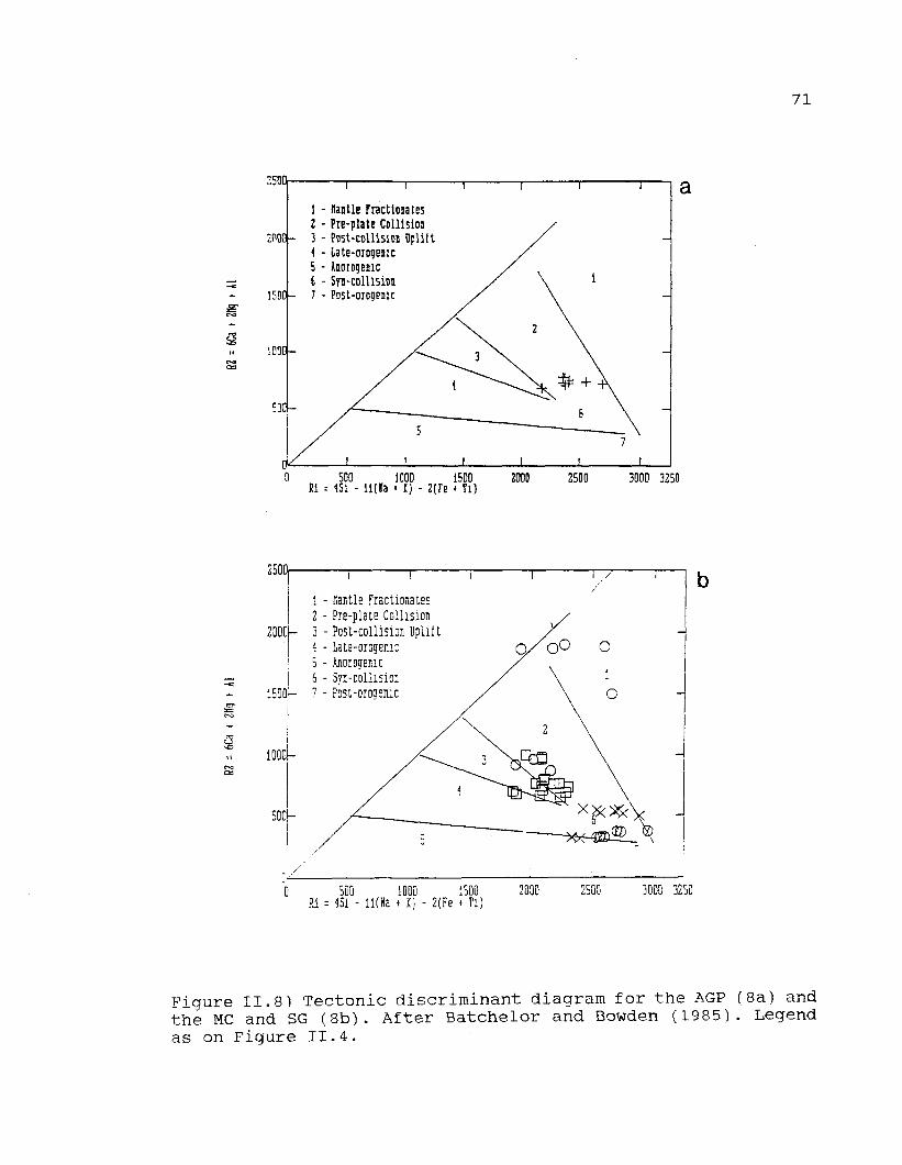
71
2500,
2P00-
!5D0-
1000-
1 - nantie FractionatesI - Pte-platt Collision3 - Post-collision Dplift4 - late-orogenic5 - Anorogemc6 - Sfj-colUsioi7 - PDSt-orogenic
500 1000 1500Si = 4Si - l l ( l a » I) - 2(Tc � TO
2OO0 2500 3000 3250
2500
iEOOf�
10001-
500{�
1 - Hantle Fractionates2 - Pre-plate Collision3 - Post-collision Uplift4 - late-orogenic5 - Anorogemc6 - Syn-collisiou7 - Post-orooenic O
0 500 1000 1500Ri = 15i - ll(Ha * I) - 2(Fe » Ti)
250G 3000 3250
Figure II.8) Tectonic discriminant diagram for the AGP (8a) andthé MC and SG (8b). After Batchelor and Bowden (1985). Legendas on Figure II.4.

72
cl timing of intrusion
The proposed ages for the SG, the AGP, and the different
units of the MC clearly indicate that none of these intrusions
are in any way related. The cataclastic nature of the contact
between the SG and all surrounding rocks indicates a faulted
contact for this particular mass. However the contact between
the hornblendite, the rocks of the main unit and the
leucogranite are all demonstrably intrusive with no evidence of
faulting being present between them.
Two possible models can be proposed to explain the
relationship between the hornblendite and the main unit of the
MC. The first is that the hornblendite and the associated
granodiorites are in no way related to the main unit. The field
evidence, which clearly indicates that the hornblendite is
younger than the main unit supports this hypothesis. However
there are many examples in the geological literature of
multiphase intrusions in which a partially evolved, relatively
high-level magma chamber is invaded by a second surge of more
primitive, but co-magmatic material from depth, followed by
mixing between the two components. This possibility cannot be
discounted here, and additional isotopic data will be required
to resolve this dilemma.
The high initial ratio of the leucogranite (0.737) clearly
indicates that this unit crystallized from a melt which was
derived by partial melting of middle to upper crustal level
material. It is possible that the heat necessary to provoke
partial crustal melting originated from a source other than the
73
main portion of the MC itself, and that the age of the
leucogranite is significantly younger than the main portion of
the MC.
d) Analogies with the Abitibi Belt of Canada
The nature of the plutonic rocks from this area, as well as
their tectonic setting and contained structural elements,
greatly resemble the Archean plutonic rocks from the Abitibi
area of Quebec, Canada. These similarities can be summarized as
follows:
1) the plutonic rocks of both areas were emplaced into
greenschist facies metamorphic rocks which contain both
metasedimentary and metavolcanic units which have undergone
more than one period of deformation.
2) the greenschist facies rocks and their associated plutons
are exposed within fault-bounded, lozenge-shaped areas. Higher
grade rocks are encountered once the bounding faults are
crossed.
3) the predominant intrusive rock types range in composition
from granodiorite to monzogranite and feature a calc-alkaline
chemistry. 4) hornblendites are found associated with the
granodiorites, as are muscovite-garnet leucogranites.
5) the primary mafic mineralogy has been substantially
modified, being replaced by secondary epidote, chlorite and
sericite. The quartz grains found in the plutons from both
areas are typically strained.

74
6) contact metamorphic aureoles surrounding the plutonic rocks
are typically rather difficult to identify.
Detailed study of the Abitibi intrusions has also revealed
the following information which may be pertinent to the area
under consideration.
1) a number of well-foliated intrusive bodies, also of
granodiorite to tonalité composition (analogous to the
Feliciano and Yi intrusions?) are believed, on chemical
grounds, to be contemporaneous with the surrounding
metavolcanic rocks.
2) high-precision U-Pb geochronology suggests that the massive
granitoids, such as those described here, are only a few
million years younger than the foliated plutons. The associated
leucogranites are of the same age as the massive granodiorites.
3) A number of shoshonitic, alkaline plutons, which are
massive, have well defined contact aureoles, and which consist
of syenite and co-existing pyroxenite, are situated within the
bounding fault zones. These rocks, which are believed to be
related to a number of calc-alkaline lamprophyres and possibly
ultramafic lamprophyres found throughout the area, are
definitately related to gold mineralization. The span of time
between the emplacement of the foliated granitoids and the
shoshonitic rocks is approximately 30 Ma.
4) Card (1990) has proposed that the sudden change of
metamorphic grade observed when crossing the limiting boundary
faults may be related to the assembly of a number of discrete
terranes, each of which has its own distinct geologic history,

75
during the Archean orogenic event. This has been discussed in
more detail in chapter 1.
e) Comparison with the southern portion of the Uruguay-
Crystalline Belt
The plutonic rocks described in this article are very
similar to those in southern Uruguay described in chapter 1. In
both areas, granitoid rocks have been emplaced into a series of
greenschist facies schists. Additionally, three periods of
pluton emplacement appear to have occurred in both areas. The
age of the South Granite (2180 ± 50 Ma) is similar to the
reported ages of 2225 ± 25 Ma for the leucogranite member of
the Arroyo de la Virgen Pluton and 2290 ± 35 Ma age for a
granitic member of the Isla Mala Pluton, (Preciozzi and Bourne,
1993). All three of these rocks have moderate initial ratios
which range from 0.707 to 0.711). Furthermore, all three
plutons have been slightly deformed (granulated grain
boundaries - see criteria presented by Paterson et al., 1989)
and are largely non-foliated, which suggests that they were
emplaced after the peak of the greenschist facies metamorphic
event had been attained. By contrast, the Feliciano and Yi
granites feature a well developed foliation; a date on either
of these rocks will enable a maximum age for the greenschist
facies metamorphism to be established. Foliated plutons such as
the Feliciano and the Yi intrusions have also been identified
in the San José Belt of southern Uruguay.

76
The age of the leucogranitic member of the Marincho Complex
(2067 ± 24 Ma - Preciozzi, 1992) is considerably younger than
any of the abovementioned plutons, however it is similar in age
to the 2040 ± 40 Ma Isla Mala granite dyke discussed by
Preciozzi and Bourne (1993). The ages of the late granitic
dykes are also comparable with those from southern Uruguay
(1925 ± 23 Ma and 1894 ± 75 Ma - Preciozzi and Bourne, 1993).
Since the pétrographie data indicate that these plutons have
also been slightly deformed to some degree, this suggests that
a mild raetamorphic event ( less intense than greenschist
faciès) affected the whole area after the emplacement of these
younger intrusive bodies, and probably resulted in the
development of the extensive secondary sericite and epidote
seen in all these rock units.
f) Contributions to a tectonic model
Bossi (1983) proposed a sequence of events for the pre-
Devonian rocks of Uruguay as follows:
1) development of a cratonic area of rocks older than 2050 Ma
located to the north of the AGF.
2) deposition of the AGF (and other similar units such as the
Paso Severino Formation further south) in ENE trending zones
3) metamorphism of variable intensity and granite intrusion
between 2050 Ma and 1800 Ma. He suggested that syn-tectonic
granites developed in the high-grade zones whereas post-
tectonic intrusions were contemporantously emplaced into the

77
low-grade zones. This period of deformation and intrusion is
known as the "Ciclo Orogénico Antiguo" (COA).
The data presented here and elsewhere (Preciozzi and
Bourne, 1993) suggest that the seguence of events proposed by
Bossi must be somewhat modified. In particular, the
geochemistry and available geochronology of the granitoid rocks
suggest that the COA may be subdivided into three phases.
The first phase (of inferred Archean age) is believed to be
related to the greenschist facies metamorphism. The marked
planar structures and other structural elements observed in the
Feliciano and Yi granites suggest that they should be
considered as syn-tectonic with the main deformational phase of
the AGB. The Marincho granodiorite is related to the end of
this first episode, that is, the geological setting is late-
tectonic. The available geochronological/isotopic data for this
intrusion (2386 ± 120 Ma; initial ratio 0.7113 and 2291 ± 65
Ma; initial ratio 0.7136 - Preciozzi 1992) suggest the
existence of an older basement. This hypothesis is supported by
the presence of alkali granite blocks which are found within
the Paso de Lugo fault zone and which have been dated at 2501
± 112 Ma (initial ratio 0.7003) and 2544 ± 38 Ma (initial ratio
0.7073) (data from Preciozzi, 1992). Field observations have
shown that the MC granodiorite is present on both sides of the
Paso de Lugo Fault, thereby suggesting that this brittle
deformation event is younger that the 2291 Ma age of the
granodiorite.

78
The second phase, as determined by field observations, is
the emplacement of the hornblendite intrusion. The
characteristic of the AGP suggest a late-tectonic setting for
the emplacement of this phase. The South Granite, dated at 2180
± 50 Ma (Preciozzi, 1992) can be related to the Paso de Lugo
Fault. This granite is contemporaneous with the well-foliated
granitoids which are found to the south of the San José Belt,
whose ages range from 2176 ± 146 Ma (initial ratio 0.719) and
2290 ± 130 Ma (initial ratio 0.712) -both ages from Bossi et
al., (in press). These ages (Preciozzi, 1992) are considered as
indicative of Transamazonian activity.
The third phase consists of the post-tectonic leucogranite
units (2067 ± 24; initial ratio 0.719) and a number of granitic
dykes (1969 ± 25 Ma; initial ratio 0.737). They represent the
very latest stages of Transamazonian activity.

79
Conclusions
1) The age of emplacement for five granitoid intrusions were
determined as follows:
- granitic blocks in the Paso de Lugo fault: 2544 ± 38 Ma
- Marincho Complex granodiorite: 2291 ± 65 Ma
- South granite: 2180 ± 50 Ma
- Marincho Complex leucogranite: 2067 ± 24 Ma
- leucogranite dykes cutting Marincho Complex: 1969 ± 25 Ma
2) The tectonic environment of emplacement of these rocks were
determined as follows:
- syn-collisional environment for the Marincho Complex
- extensional environment for the Arroyo Grande Pluton
3) These data, combined with the data presented in chapter 1 of
this report, suggest that there are three distinct periods of
emplacement of granitoid rocks in the Precambrian of southern
and central Uruguay as follows:
- Archean rocks. The massive alkaline granite blocks, dated
at 2544 Ma, prove that the greenschist facies metamorphism and
associated deformation is older than this age.
- 2290 - 2180 Ma: Intrusion of small to medium-sized
plutonic rocks, some of which are composite in nature. The
older intrusions are calc-alkaline whereas the younger are
alkaline.
- 2040 - 1894 Ma: Intrusion of a number of small dykes
which cross-cut the plutons formed at stage 2.
80
CHAPTER III
AN OVERVIEW OF THE GEOLOGY OF THE PIEDRA ALTA TERRANESOUTH-CENTRE AND SOUTHWESTERN URUGUAY
WITH A PROPOSED MODEL FOR ITS TECTONIC EVOLUTION
81
Foreward to Chapter 3
Having presented geochemical and radiometric age data as well
as a preliminary tectonic interpretation for some of the Piedra
Alta Terrane granitoids in chapters 1 and 2, it is now useful
to see to what extent these interpretations coincide with the
currently popular models for this area. It will be seen below
that these models, which are largely based on previous studies
of the other types of rocks which are found in the Piedra Alta
Terrane, must be modified in order to accomodate the tectonic
and geochronological data provided by a study of the
granitoids.
In order to do this, it is first necessary to provide an
overview of the geology of the Piedra Alta Terrane. This
overview is presented in the first 2/3 of this chapter. The
geological information presented for the five granites in
chapters 1 and 2 are sufficiently detailed for our requirements
and are not repeated here. The remaining 1/3 of the chapter
presents a model for the tectonic evolution of the Piedra Alta
Terrane.
Many references are made to place names throughout this
chapter. For readers unfamiliar with the geography and
political divisions of Uruguay, a sketch map showing the
locations of the various Departments (Provinces), as well as
many of the place names mentioned in the text, is presented in
Figure Ill.l.

82
CERRO LARGO
RIO NEGRO
DURAZNO
San Juan
COLONIA i . / � \San José
Mayo/CANELONESAtlanticOcean
DURAZNO Department (political division) Durazno» City or Town
Montevideo H Capital of Country U C r u z o Village
Figure III.l): Location map of the departments as well as manyof the place names mentioned in the text.
83
Introduction
The Piedra Alta Terrane (see Figure i-1) consists of a
litho-tectonic assemblage with a predominantly EW trend. The
region can be subdivided into three subparallel, narrow,
metamorphic belts, of varying metamorphic grade, which are
separated from one another by granite-gneissic areas (Figure
III.2). Magmatic rocks of different composition, age and
tectonic environment of emplacement have intruded the whole
terrane.
The three metamorphic belts will be described separately,
followed by descriptions of the granite-gneiss complex and the
intrusive rocks. In all cases, each unit will be described
presenting all the data currently available.
I: THE VOLCANO-SEDIMENTARY BELTS
ARROYO GRANDE BELT
A metamorphic belt known as the Arroyo Grande Belt (AGB) is
located at the northern border of the Piedra Alta Terrane, near
the Yi River (Department of Durazno). Several different
plutons, two of which have been described in some detail in
Chapter 2, are intrusive into the metamorphic suite, (see
Figure III.3). The main area of the metamorphic rocks, which
trend E-W, extends from Paso de Lugo in the west to several
kilometers east of Arroyo Malo del Yi in the east.
Variations of the main strike are frequently observed,
particularly near the plutonic bodies. Dips are subvertical and
towards the south. Primary structures preserved in the

84
metasedimentary rocks (cross-bedding), reveal that the bottom
of the series is in the north and abuts against the Paso del
Puerto granite (see Figure III.3). A fault of significant
lateral extent (Paso de Lugo fault) forms the southern boundary
of this sequence and tectonically separates the metamorphic
belt from a large area of undifferentiated granitic rocks to
the south.
Generally speaking, detrital rocks predominate near the
base of the sequence, however amphibolites and amphibolites
with quartzites are locally intercalated with them. Basic
metavolcanic rocks predominate along the southern margin of the
belt. Locally they have been metamorphosed to either chlorite
schists or amphibolites. The detrital sequences have been
intruded by several granitoids bodies eastwards. The contacts
of the Feliciano and Yi granites are mylonitic in nature.
Petrography of the detrital sequence
The most volumetrically important rocks of this sequence
are impure (feldspathic) or pure quartzites. They are
associated with metaconglomerates that have a phyllitic or
sandy matrix, which has been recrystallized to different
degrees, surrounding pebbles which range in diameter from 1 to
20 cm. The quartzites are slightly bedded and have grains which
can be observed with the naked-eye (0.5 to 1 mm.). Some of the
quartzites are of low metamorphic grade, having preserved
85
«ISarandidel Yi
SANTA LUCIAGRABEN
Granite-gneisscomplex
v vV
Intrusive rocks
Supracrustal rocks
Fault
Cambrian extensional magmatism
MONTEVIDEO BELT
50
km
100
Figure III.2: Sketch map showing the location of the threemetamorphic belts of southern Uruguay. After Bossi et al.(1993)

�>
t-br t(Dhj
i-qfDh<
3ft)3(X(DN
ft)3a
h{fDOp -0NNP-
�s197
� �
Mdr t03cnH-3
r t3"(D
fDft)cnr tfD
3
or tP-03
0i-b
r t3*fD
UfDIt.
1
3"(D
W*fDf t*"1P-r tft)t��
cnfD
fD
ofDcn
3"ft)
fD
Lnti
d
fD
cr
C/lfD
(D
ft)P"
3P-r tOp .
crfDMr t
� «
3(Dft)h^
f t3"fD
cnd
gH-r t
0
r t3"(D
Olea
301cnfDaim
ent
ft)
H-h-'fD
T3
(D
0
H-3ft)r tfD
H-3
f t3"rocnodr tfD1^
3
O0
rtH-03
0H)
r t3 *CD
0dr t0
013
ft)
fDft)
0
f t3"fD
cno(Dr t
fDcnr thjft)3cni~h0
g(D
H-3r tO
ft)
3"ibo
MH-r tfDcnft)3a.otrM0i-iH-rtfD
cno3*
cnr t
dft>
r tNH-r tfl>cn
ft)
fD
o*U-J
[~.
bjfDcnfD
r t
tt)ft)cnH-0
me
t
ft)<oM0ft)3p-O
00
cn
p-
d
fD
HHH»
� �
nfD0M0
p-
nft)
gft>Tl
0
rt31CD^ i
i-ii-j0<O
oQJ
*
rjd(DMrt
10
ARROYO GRANDE BELT
Sedimentary rocks
^�"1 Basic volcanic rocks
+ I Undifferenciated granitoids
Southern granitoids
- 1 - Arroyo Malo granodiorite
L * A | Arroyo Grande granodiorite
MARINCHO COMPLEX
L L | Granodiorite main unit
Hornblendite
km
South granite
Leucogranite
Carpinteria granodiorite
Feliciano granodiorite
Yi granite
X X
I L
� � �
OD

87
primary structures. Recrystallization is better developed at
the base of the sequence as well as immediately adjacent to the
intrusive rocks. Microscopic observations of the less
recrystallized quartzites reveal that the quartz grains, having
their original shapes, are set in a microcrystalline sericitic
matrix. Such rocks also contain chlorite, muscovite, garnet,
biotite and opaques. Also present are only slightly
recrystallized anhedral quartz lenses. The most recrystallized
quartzites have a very fine granoblastic groundmass of anhedral
quartz and biotite, with larger poikiloblastic albite, chlorite
and garnet crystals. Pyroxenes have been found within the
quartzites near the contacts and within granodiorite enclaves
however as a whole the observed parageneses are consistent with
low grade metamorphism.
Petrography of the volcanic sequence
The most important rock type of this sequence is a basic
metavolcanic rock featuring a palimpsestic texture. Phenocrysts
(1-8 mm. of euhedral labradorite) are set in a fine-grained
actinolitic nematoblastic matrix. Less common plagioclase-
amphibolites, intercalated within the detrital sequence
described above, feature recrystallized amygdules which have
been transformed into quartz lenses of 1 to 8 mm. length.
Along the southern border of the basic sequence, where the
dynamic effects of Paso de Lugo fault were very intense, the
volcanic sequence develops a variety of textures ranging from
lepidoblastic to cataclastic. The main minerals in this area
88
are chlorite, epidote (pistacite), albite, quartz, opaques
minerals and calcite (perhaps secondary).
Metamorphic Mineral
No systematic study of the mineral assemblages present
within the Arroyo Grande Belt has yet been carried out. The
data currently available indicate that the The AGB consists low
to medium grade metamorphic rocks as mentioned above. Mineral
assemblages which have been noted in the AGB rocks are
indicated in Table III.l.
Chlorite and biotite are present in both detrital and
volcanic rocks. It is probable that the local presence or
absence of these minerals is compositionally controlled. The
presence of garnet co-existing with chlorite in some of the
detrital rocks suggests that the metamorphic conditions
approached those of the greenschist faciès - amphibolite faciès
boundary, (Winkler, 1970). The difficulties of working on
greenschist faciès rocks are well known (see comments in Will
et al., 1990) and it is unlikely that a significant improvement
in our knowledge of the metamorphic petrology of these rocks
can be made easily.
89
Tectonic evolution
Conclusions concerning the tectonic and stratigraphie
evolution of this region are based on an analysis of the
behaviour of the metamorphic rocks. Analysis of schistosity,
folding lineation, and maximum deformation axes in the
metaconglomerate pebbles (stretching direction) reveal the
presence of at least three phases of deformation. Relations
detected between linear elements, such as the opposite plunge
sense observed in the eastern and western portions of the AGB
(Figure III.4), as well as the central position of the Marincho
complex, can be related to the first two deformational
episodes.
The first one (of inferred Archean age), of regional
extent, generated isoclinal folds. Its presence has been
recorded by the deformation in pebbles of some conglomerate
layers. The Arroyo Grande mafic sequence probably formed
subsequently by injection along the southern structural
discontinuities during the late stage of the evolution of the
metamorphic belt. This kind of evolution is also suggested by
the presence of basic metavolcanic rocks which are located
along the contact between the Yi and Feliciano granites. The
marked planar structures and other structural elements observed
in these two granites suggest that they should be considered as
syntectonic, contemporaneous with the main phases of
deformation in the AGB.

9 0
� � Long axes of deformedclasts
�O Microfold axes
�(�) General folding axes
Figure III.4: Stereonet (upper hemisphere projection) showingthe contrast between the eastward and westward plunge ofstretching lineations and microfold axes in the eastern andwestern portions of the Arroyo Grande Belt.
After Fernandez and Preciozzi (1974)

91
Table III.lMINERAL ASSEMBLAGES OBSERVED IN THE ARROYO GRANDE BELT
SequenceDetrital 1 x x x(in north) 2 x x x x
GA EP ZO CA OM AM SP± XX X X
3 X XVolcanic 4 x x
(in south) 5 x x6 x x
x xxx
XXX X
Assemblages 1 and 2 were recorded in the detrital rocks in thenorthern portion of the AGB. Assemblages 3 - 6 were observed in thevolcanic rock, situated in the southern portion of the belt. QZ =quartz; PL = plagioclase; CH = chlorite; MU = muscovite(undifferentiated white mica); BI = biotite; GA = garnet; EP =epidote (pistachite); ZO = zoisite; CA = calcite (undifferentiatedcarbonate); OM = opaque minerals (undifferentiated); AM =amphibole; SP = sphene (titanite)
92
The Marincho complex intrusive granodiorite is related to
the terminal stages of this first episode of plastic
deformation. Tectonic evidence, such as the elongated form of
the intrusion which is concordant with the regional structure,
suggests a late-tectonic character for this intrusion. Two
different whole rock (Rb/Sr method) age determinations for this
granodiorite (Preciozzi, 1992) have yielded values of 2386 ±
120 Ma (Ro = 0.7113) and 2291 ± 65 Ma (Ri = 0.714). This
intrusion produced an important variation in the spatial
orientation of rocks in both eastern and western zones.
The metavolcanic and metasedimentary rocks were intruded by
this granodiorite and therefore they are obviously older. The
existence of an even older basement is supported by the
presence of allocthonous blocks of alkaline coarse-grained
biotite granite observed in the Paso de Lugo fault. This fault
formed during a period of brittle deformation which followed
deformational episodes described above. The granitic blocks
have yielded Archean ages: 2501 ± 112 Ma (Ro= 0.7003) and 2544
± 38 Ma (Ro= 0.7073) - Preciozzi (1992). Presumably they
represent exotic fragments which have been tectonically
incorporated into the fault zone. The fact that there is an
elongated outcrop of the Marincho granodiorite on the southern
side of the Paso de Lugo Fault suggests an age younger than
2291 Ma for this brittle tectonic event.
The second deformational event formed in response to an E-
W compressional stress. This event modified the orientation of
the Dl linear structural elements, generating N-S to NE-SW

93
axial planes. The Marincho granodiorite is situated in this
axial plane. An extensional event near the end of this phase is
believed to be responsible for the intrusion of the
hornblendite band which cuts across the Marincho complex.
The emplacement of the Arroyo Grande granodiorite appears
to have been controlled by NE-trending (ie D2) structural
elements, and we therefore believe that this intrusion is late-
tectonic with respect to this deformational episode.
The South Granite, (2180 ± 50 Ma - Preciozzi, 1992) is
quartz-rich muscovite- bearing granite with mylonitic textures.
Its mineralogical and textural features and its shape suggest
an emplacement simultaneous with the major activity of Paso de
Lugo Fault. This granite can be correlated with the foliated
granites developed at the south of San José belt with reported
ages between 2176 ± 146 (Ro= 0.7090) and 2290 ± 130 Ma (Ro=
0.7120), Bossi et al., (in press).
The third deformation phase is associated with post-
tectonic leucogranites (2067 ± 24 Ma; Ro= 0.719) and granitic
dykes of 1969 ± 69 Ma (Ro= 0.7345). Such ages, both from
Preciozzi (1992), are normally considered as indicative of
Transamazonian activity.
The sequence of tectonic events which are currently
believed to have affected the AGB are presented in Table III.2.
94
San José Belt
This name was proposed by Preciozzi et al. (1991) to
designate a belt which forms a roughly east-west trending band
across southern Uruguay (Figure III.l), and which extends from
Cerros de San Juan (Department of Colonia) to Fray Marcos
(Department of Florida). The belt consists of rocks of both
volcanic and sedimentary origins. The metamorphic grade
increases from low to medium grade in a southerly direction.
Figure III.5b shows the regional lithological distribution
after Bossi and Navarro (1991) in order to point out the
structural style of this metamorphic belt. An enlargement
(Figure III.5a) is presented for the most complex sector
(Department of San José).
The term "San José Belt" was proposed to group together
several metamorphic units including the Paso Severino Formation
(Bossi et al., 1965), the San José and the Cerros San Juan
Formations (Preciozzi et al., 1985). This name is retained
here, because it eliminates several obscure points in previous
lithostratigraphic separations.
The Francis and Mones (1965) and Andreis and Mazzoni (1967)
definitions of the San José Formation, which they used for
naming the upper part of the Kiyu klippe which is a continental
sedimentary infra-Pampean unit, was not accepted by later
authors. Hence, this proposal is not an obstacle for using this
geographic term to name a Precambrian metamorphic belt.

95
Table III.2
TECTONIC EVENTS RECORDED IN THE ARROYO GRANDE BELT
Age Units Events Domain
(Ma)
1969
2067
leucogranitedykes
leucogranite 3rd. deformationalphase
Transamazonian
2180
2275
SouthGranite
contemporaneouswith Paso de LugoFault
Arroyo extensionalGrande grano- environmentdioritehornblendites 2nd. deformation
phase
pre-Transamazonian
2291-2386 Marincho maingranodiorite
2501-2544 Alkaline-granite blocks
Arroyo Grandebelt metamor-phic rocks
metamorphism and1st. deformationphase
Archean

96
V\\\
\
0 5
km
NS
m. Low grade metamorphic rocks
Medium grade metamorphic rocks
Granites
Gabbros
Fault
C Cufre Pluton
M Mahoma Pluton
MA Mai Abrigo Pluton
SJ Cerro San JosePluton
Cerros deSan Juan
to Fray Marcos(30 km)
San Josebe Mayo
to Montevideo(65 km)
Figure III.5: (5b) Geological sketch map of the San José Belt.The rectangular area shown on Figure III.5b has been enlargedand presented as Figure III.5a, on which regional structuraltrend lines have also been shown.

97
Outline of the Petrography of the San José Belt
A considerable lithologie variation has been - observed
within this tectonostratigraphic unit both along the strike of
the belt as well as across the belt. Between Paso Severino and
Fray Marcos, the rocks are typically low grade varities and
include carbonaceous shales, sericitic phyllites, and graphitic
quartzites.
In Department of San José (currently the type locality) the
same lithologies have been recognized as those described by
Bossi et al. (1965) and Bossi and Navarro (1991) from Paso
Severino (Department of Florida). However these authors also
noted the presence of extensive areas of basic metavolcanic
rocks, (greenschist facies chlorite schists) interbedded with
the metasediments at Paso Severino.
Westwards, in Department of Colonia, thick accumulations of
metakeratophyre have developed, and this fact allowed Preciozzi
et al. (1985) to subdivide the Cerros San Juan Formation into
two major units. This separation was considered inconvenient in
later interpretations and will not be employed in this work.
The volcano-sedimentary sequence in the western section of San
José belt includes dolomites, talcschists, chloritic phyllites
and the aforementioned metakeratophyres. Manganiferous horizons
associated with this volcanism were described by Serra (1945).

98
Tectonic History of "the San José Belt:
Campai (1990) recognized at least two plastic deformation
phases in this belt: the first one, syn-metamorphic, generated
tight folding with subvertical ENE axial planes; the second one
is associated with open folding with N45W axial planes.
Interference structures and the emplacement of granite-gabbro
are associated with this second phase. À brittle deformation
episode between these two periods of plastic deformation has
been recognized by Campai (1990) and surveyed in some detail by
Garat (1991) in the Guaycurû area. Mylonitic rocks generated
during this phase were folded during the second period of
plastic deformation. This information is presented in summary
form in Table III.3. The similarity between the sequence of
events proposed for the San José Belt and that for the
previously described Arroyo Grande Belt is striking.
Some authors interpreted these associations as a greenstone
belt of possible Archean age (Fragoso et al., 1987; Feselfeldt,
1988) but the absence of komatiites and other ultrabasic rocks,
and the predominance of non-pelagic sedimentary sequences,
suggests that this hypothesis should be disregarded.
Different authors have interpreted the talcschist of
Pietracaprina (Department of San José) and Paso del Pelado
(Department of Colonia) as having formed by metamorphism of
pre-existing ultrabasic rocks. However the talcschists are
always associated with dolomites, and tremolite is present in
every paragenesis where talc appears (Bossi, 1978). This belt
99
Table III.3
TECTONIC EVENTS RECORDED IN THE SAN JOSE BELT
Aae Ma Units Events
1800
18941925
2000
2040
2070-2100
2100-
2225
2290
2450
doleriticdykes
extensionalenvironment
-CRATONIZATION-
Aplites andgranitic dykesof A. Virgen
granite-gneisscomplex
granitic dykeof Isla Mala
Metamorphism,migmatization,granitizationand folding
A. VirgenLeucogranite
Isla Malaleucogranite
Isla Malagranodiorite
late-orogenic
Development ofvery importantmylonite zones
POSTTRANSAMAZONIAN
TRANSAMAZONIAN
OROGENESIS
PRETRANSAMAZONIAN
2500+ Development of the San José belt withfirst major phase of deformation older ARCHEANthan 2500 Ma

100
contains meta-dolomitic lenses in several places but to date no
meta-limestones have been recognized.
Metamorphic Assemblages
The metamorphic grade of the rocks in the northern portion
of the San José belt is low to very low. Primary metavolcanic
amygdules can be recognized in spite of the deformation.
Amygdules in basic metalavas are indicative of gas elimination
and consequently, shallow water depth during development of the
volcano-sedimentary sequence. Some higher-grade greenschist
faciès rocks exhibit complete metamorphic recrystallization and
are characterized by the presence of actinolitic amphiboles and
intensively saussuritized plagioclases.
In Department of San José, rocks grade gradually southward
into medium grade metamorphic rocks (San José Formation,
Preciozzi et al., 1985). According to these authors, the
metamorphic belt in this area consists of interbedded gneisses,
amphibolites, leptinites, quartzites and micaschists.
Quartzites and leptinites are very scarce while amphibolites
are common. Gneisses are leucocratic and well foliated,
containing quartz, microcline, plagioclase, biotite and
muscovite. Two-mica schists contain quartz - kyanite
staurolite and garnet. This assemblage is univariant in the
model system SiO2 - A12O3 - FeO - MgO - K20 - H20 and requires
pressures considerably in excess of that of the aluminosilicate
triple point in order to form. Sillimanite has also been
recently recognized in these rocks. In the same micaschists and

101
in carbonaceous shales, andalusite (chiastolite variety) is
frequently found, usually in close relation with granitic
intrusive bodies. These observations require that a significant
amount of erosion occurred between the time of the development
of the regional metamorphic mineral assemblages and those
developed in the contact aureoles of the granites. The presence
of the talc + tremolite assemblage in the enigmatic talcschists
mentioned above is also indicative of relatively high pressures
of metamorphism. Several authors including Skippen (1971, 1974)
and Slaughter et al., (1975) have proposed on the basis of
experimental evidence that this assemblage should not develop
at low pressure and should be comparatively rare at medium
pressure. According to these authors, only at relatively high
pressure (approximately 5 kb) does talc + tremolite become a
common assemblage.
Montevideo Belt
This roughly east-west trending metamorphic belt is
situated along the extreme southern margin of the Piedra Alta
Terrane in the Departments of Montevideo and Canelones (Figure
III.2). Walther (1948) has provided some detailed pétrographie
information on the rocks of the Montevideo crystalline
basement, however very little additional lithologie information
has been accumulated during the intervening 45 years.
Consequently the present knowledge about this lithologie unit,
named the Montevideo Formation by Bossi et al., (1965) is quite
scarce.

102
The three main lithologies so far identified are:
oligoclase gneisses, amphibolites, and micaschists. The
structural conformity and homogeneity of metamorphic faciès
were the main criteria used to define the formation. Cardellino
and Ferrando (1969) included every crystalline rock outcropping
in this department within the Montevideo Formation except the
much younger "La Paz" granite. The authors described different
kinds of migmatites and anatectic granites but at the same time
they proposed to disregard the concept of migmatization when
defining this unit.
The following comments pertain to those models so far
presented concerning the rocks of this formation.
- although the "La Paz" granite is correctly excluded, the
inclusion of "all the Department of Montevideo crystalline
rocks" into Montevideo Formation is not geologically
reasonable. This proposal is in fact a geographical grouping
and does not have a lithostratigraphic meaning.
without a particular geological context or frame of
reference, the term "anatectic granite" is not a useful
descriptor because all magmatic rocks, are, in fact, of
anatectic origin.
- if migmatization processes may be disregarded, the inclusion
of migmatites by Cardellino and Ferrando (1969) among the
lithologies is not understandable.
- the recognition of the "Pajas Blancas" banded amphibolites as
paragneissic rocks with preserved primary layering should be
considered as an important contribution.

103
Later authors like Bossi et al., (1975); Preciozzi et al.,
(1985); Bossi and Navarro (1991) didn't change the previous
geological interpretations, accepting them without discussion.
Consequently these authors didn't present a reasonable
explanation for the observed coexistence of medium-grade
muscovite-bearing metamorphic rocks and high grade granitized
areas. The study of the Mosquitos quartzites and adjacent
migmatites made by Oyanthçabal in Preciozzi et al. (1985) may
be considered the only exception to this statement. Yet even
here the study is far from satisfactory since these two
different lithologies were incorrectly mapped as being
structurally concordant. The original criteria of structural
concordance as a main feature for grouping lithologies into the
Montevideo Formation is in fact, not essential, and is very
hard to verify with outcrop which is not only scarce but also
of poor quality. Furthermore, this concordance can only be
applied to the paragneisses and doesn't necessary exist between
the paragneisses and the rocks which have an igneous protolith.
As a result of an imprecise lithostratigraphic definition,
the boundaries of the Montevideo Formation have not yet been
precisely determined. The northward and westward extents of the
formation are unknown, and the Santa Lucia graben conceals its
structural relationship to the metamorphic rocks which are
exposed along the northern margin of this rift-valley.
The name Montevideo Belt is proposed here for designing
only the metamorphic rocks whose main lithologies were

104
described by Bossi et al. (1965) as representing the Montevideo
Formation (see Figure III.6).
The lithologies included in Mosquitos Formation (Campai et
al., 1988) are proposed here as the northern limit of the
Montevideo belt, since the rocks of this formation are situated
along a very important tectonic boundary. According to these
authors, the Mosquitos Formation can be defined as consisting
of strongly deformed peraluminous granitic rocks which were
emplaced in an east-west trending structural lineation which is
situated between Toledo and Soils Grande rivers. This lineation
abruptly separates a medium grade metamorphic belt to the
south, from a granitic-gneissic domain to the north. Anatectic
conditions were frequently attained in this northern domain.
In the southern belt two-mica oligoclase gneisses, ortho-
and para-amphibolites, micaschists and graphite paragneisses
have been recognized. Ortho-amphibolites (described in
considerable detail by Walther, 1948) crop out in both
prominent hills within the Montevideo city limits. Its
nephritic textures gives a high weathering resistance that
explains the resulting geomorphology.
Reasonable exposures of the para-amphibolites and
micaschists can only be observed in coastal outcrops or in

(D
HH
QfDO
QH-
o
w
rto
0)
o
rttro>
SO3rtfD
H-D,(DO
(DMrt
V
t- -
V
^ �+
\ \ l \U Mylonite zone
Cambrian igneous rocks
Mosquitos Formation
Granitoid rocks
Northern limit of Montevideo Belt
� �� Northern limit of the Montevideo Formation
SANTA LUCIA GRABEN
oen
106
quarrys. They are structurally concordant and the best
exposures are at Pajas Blancas for the amphibolites and
Frigorifico Nacional for the micaschists.
Metamorphic observations
Professor N. Campai (pers. comm., 1991) has made the
following observations:
1) metamorphic assemblages developed in the micaschist include
muscovite, biotite, almandine garnet, staurolite, andalusite,
plagioclase, quartz. The andalusite and staurolite form
centimetre-scale crystals.
2) The texture displayed by the andalusite in outcrop and the
lack of neighbouring granitic stocks suggest that this mineral
formed as a consequence of regional metamorphism.
Graphitic paragneisses which are exposed near Soca are
clearly discordant with respect to the peraluminous granites
belonging to Mosquitos Formation. These kinds of gneisses are
local faciès in lithologies with quartz, oligoclase, and
biotite as essential minerals.
In this metamorphic belt a typical medium- to high- grade
assemblage of andalusite-muscovite-staurolite-garnet-biotite-
quartz has been recognized, and in addition migmatites are
locally present. The metamorphic assemblage suggests that the
pressure of metamorphism must have been relatively low, and
therefore suggests that the contact between these rocks and the
anatectic granite is probably tectonic, an hypothesis which has
been confirmed by field study.
107
Tectonic History
From the structural point of view, the medium-grade
metamorphic rocks develop N 70E - N 70W axial planes in tight
folds with subvertical axes (first plastic deformation phase).
Variation in the strike of the axial plane strike can be
related to at least one north-south regional compressional
phase which generated a dextral shear strain with the general
strike orientation of N20W - N40W. This last episode of
shearing affected all rocks belonging to the Montevideo Belt.
II; GRANITIC-GNEISS COMPLEX
The granitic-gneissic complex and related migmatites occupy
the entire area between the Arroyo Grande and San José belts
(see Figure III.2). The complex consists mainly of anatectic
foliated and porphyritic granitoids. These kind of granitoids
are oval in shape and they have been emplaced into different
kinds of gneisses. Ages close to 2000 Ma have been determined
by the Rb-Sr method on granitoids and migmatites belonging to
this complex.
Two plastic phases and one brittle phase of deformation
have been recognized in this granitic complex (Campai, 1990).
The first one is a plastic deformation phase which generates
tight folds with subvertical axes, and N 70E trending axial
planes. A second thrusting phase is associated with
peraluminous muscovite granites and related mylonite
development.

108
East-west structural lineations, particularly well
developed near the village of Ismael Cortinas (Figure III.5),
(Campai, 1990; Garat, 1990), can be related to this phase. Open
folds and NW structures were generated during a third
deformation phase. Anatectic phenomena and intense bimodal
magmatic activity developed contemporaneously. The main
structural lineations (Campai, 1990) are illustrated in Figure
III.7. These kinds of structures were surveyed at 1/100.000
scale by Campai and Chulepin (1991) and Garat (1991).
Figure III.8 is a geological map for a small area near the
village of La Cruz (Department of Florida). Several relict SI
schistosity planes, trending N 70E, are shown, Also visible is
a slightly convex mylonitic S2, and a second plastic NW
trending deformation phase (S3). Also indicated on the map are
areas of massive (isotropic) granodioritic rocks.
The first plastic deformation phase is presumed to be
contemporaneous with the primary metamorphism of the volcano-
sedimentary pile - that is, the rocks which constitute the
different metamorphic belts previously described. The second
deformation phase is associated with a dynamic tectono-thermal
event generating mylonitic S-surfaces. The third phase, again
of plastic deformation, generates tectonic transposition

109
s
coO
âCO
O>
>>
> >
COT3'5'E2O)(U
siv
i
co«E"ococoCD<
4+ 4
+
CO0)coco'5Co>çcgeu'�v
c0
ati
Foli
c'cô
yf/f
Figure III.7: Trend lines for the granitic gneiss complex andthe San José Belt, southern Uruguay (after Campai, 1990)

Qtu drt i-i(D (D
H) (D H-{(D
O0)3
D)
O
OO
H
3 "(D( D Of i (D
rtt
rt fiO
OH,
0)
N
I0)
0 SH) (!)
H-HJ enH enO (Di-j enH-
0) 5
^
yy
x x x- " X X
X X X X X
X X X X X X X
X X X X X X X
x x x x x x x x x\ \ x x x x x x x x x x
X X X X
^ X X X
/ X X X
/ X X X
X X X
X X /^X*
x *< / / v
X X
^1-+-
Gneissic granitoid rocks
Peraluminous granite
Main foliation direction in granitic gneisses
Amphibolite
Mylonite
HHO

Ill
phenomena on the SI and S2 planes. This phase may be recognized
by an intense thermal activity. Quartzofeldspathic
remobilization has taken place in shallow metamorphic rocks and
anatexis in lower crustal level areas. According to Campai
(1990), the simultaneous evolution of basic and acid magmas is
the main magmatic feature associated with this plastic phase.
Anatectic granitoides are found at the lowest crustal
levels. They are more or less allochthonous and strongly
related to basic magmas (dioritic). Mixing and mingling
phenomena are frequently observed (Piedra Alta and Cerro
Colorado; Department of Florida). At shallower crustal levels
the metamorphic rocks are intruded by granite-gabbro complexes
(Mahoma, Department of San José).
A geological and geochronological study of the Cerro
Colorado granite (see location map, Figure III.l) has recently
been carried out by Cingolani et al. (1990). The Cerro Colorado
granitoids feature a nucleus which is typically several
hundreds of meters in diameter and which is characterized by
the presence of prismatic megacrysts. North-west trending
amphibolitic migmatites surround these granitic nucleii (see
Figure III.9). Under the microscope, slightly perthitic
microcline megacrystals are surrounded by a biotite, quartz,
oligoclase (An 25) matrix. Textural evidence suggests that
microcline crystallization was a late stage phenomenon. Local
anatexis of pre-existing rocks is the origin suggested by the
authors for this granitic body. A Rb/Sr whole rock age of 2071

112
37° 60
61C70
Porphyroblasticgranite
Gneiss
Structural trendlines
Fault
10
km
Figure III.9: Structural sketch map of the gneisses and relatedrocks near the town of Cerro Colorado

113
± 71 Ma with Ro= 0.7011 (Cingolani et al., 1990) was obtained
based on seven cogenetic samples. The age is one typically
associated with the Transamazonian deformation, and the
isotopic data are consistent with mantle values for Archean
times (initial ratios between 0.7000 and 0.7003).
The granitic body located near the city of Florida, in
particular at the Piedra Alta and El Prado quarries, show the
characteristics of the deepest level of the Transamazonian
domain dated at 2030 ± 75 Ma (Rb/Sr whole rock, recalculated
from Umpierre and Halpern, 1971). The quoted authors described
the intrusion as consisting of granitic and granodioritic
rocks, with subhorizontally layered structures and a sharp
contact between them (Figure III.10). They are crosscut by
granodioritic and microdioritic dykes, and there was
significant late-magmatic (hydrothermal) activity. In the upper
portion of the intrusion there is a leucocratic granular rock
with turbulent flow structure lacking a preferred orientation.
It shows grain size variation ranging from coarse-grained
(centimetre scale) to medium-grained. Sometimes this
leucocratic rock contains miarolitic or pegmatitic "bubbles".
The main minerals are oligoclase, microcline, quartz and
biotite, with amphibole, epidote, sphene, apatite and muscovite
being present in smaller amounts.
Also identified in the area are syn-magmatic dykes that
were folded and "boudinaged" by movement within the magma
chamber with different stress and dragging directions. The main

Bridge over Rio Santa Lucia LA PIEDRA ALTAOUTCROPS
114
8 10
SW
CROSS-SECTIONA-B
NE
C-D N
Microdioritedyke
j.+*+* Coarse-grainedgranitoid
Medium-grainedgranodiorite
Fine-grainedgranodiorite
Aplite
Qz-feldsparveinlet
Fracture
Fault
Figure III.10: Outcrop-scale map of the granitoid intrusions inthe Piedra Alta Quarry, near the city of Florida. A 10 metergrid system is shown for reference.
115
rock in the basement is raelanocratic, fine-grained, and
isotropic. Volumetrically, the most important minerals are
plagioclase, K-feldspar, quartz, hornblende and biotite with
lesser amounts of apatite, sphene and epidote. It is classified
as granodiorite.
Quartz-feldspar dykes and veinlets intruded the basement
rocks under both plastic and brittle conditions. Syn-niagmatic
dykes flexured and folded by the magma motion have also been
described. Considering the existence of continuous
interpénétration and diversity of structures generated, we
think that the leucocratic and melanocratic components have
evolved as two melts without great thermal contrast between
them. This would explain the fact that there are not important
compositional variations, although chilled margins are present.
Besides this there are also mutual inclusion phenomena and
interpénétration among the rocks. This zone was supersaturated
with respect to water. During the end- magmatic stage fluid
pressure could produce fracturing in a melt which has
crystallyzed more than 50 %. Microdiorite dykes such as the
ones located at co-ordinates A-5 and 1-2 of Figure III.10,
which show lobate boundaries and interpenetrate the host rock,
seem to have be emplaced with viscosity contrast into an
incompletely crystallyzed host rock (50 % crystals). Magma
mingling is the phenomenon considered for this rock assemblage.
This kind of granitic stock may be considered as a locus of
melting within the metamorphic complex. These metamorphic rocks
(mainly gneissic granites, amphibolites, and gneisses) have

116
been described by Campai and Chulepin (1990) in the 1/100.000
Talita Sector Geological Map.
Gneissic-granites are only exposed in quarries. They have
inequigranular texture, in which feldspathic megacrysts are set
in a matrix consisting of quartz, plagioclase and biotite.
Foliated gneisses envelop these granitic nucleii. Amphibolites
appear as enclaves within the granitoids or as lenses in the
gneisses which range in size up to several tens of meters. In
some cases the amphibolites are foliated and folded while most
of outcrops are isotropic in nature. This strongly suggests
that the amphibolites have experienced a previous tectonic
history.
One of the outstanding features of this area is the
scarcity of metasedimentary rocks which form discontinous bands
and contain significant volumes of remobilized quartzo-
feldspathic material. These features are the main differences
between the gneiss terranes and the metamorphic belts described
above. The quartz-feldspar remobilizations are present in the
form of microgranites, aplites and pegmatite dykes.
These main lithologies are systematically cut by
microgranite dykes which have no preferred values of either
strike or dip. They have homogeneous fine grained textures and
consist of quartz, oligoclase, K-feldspar and biotite. Biotite
is present as strongly undulated pleochroic plates and is very
similar to that found in the granodiorites.
Pegmatites with very simple mineralogy, and with only
biotite as an accessory mineral, are intimately associated with

117
microgranites cutting amphibolites, gneisses, and foliated
granites. Lenticular shapes are specially developed by these
pegmatites in the Departments of Florida and Flores. The major
axes of these lenses are subhorizontal and are several tens of
meters in length and up to 3 meters in thickness.
The band developed between the San José and Montevideo
Belts must be tentatively included into this granite-gneiss
complex. The exposed area of this sub-2one is of limited extent
since a large part of it forms the floor to the Santa Lucia
graben. The most informative outcrops of these rocks are found
in the vicinity of Ecilda Paullier, Estaciôn Gonzales, and
Carreta Qumada The Bocas del Rosario quarries and the AFE
quarry at the town of Suarez also have good exposures of these
rocks.
The AFE quarry, which may be taken as a typical example,
was described by Coronel and Oyhantçabal (1988) as consisting
of heterogeneous migmatites with dictyonitic and stromatic
structures (sense Mehnert, 1968) which vary laterally into
gneisses or granitic rocks consisting of oligoclase, K-
feldspar, quartz, biotite, epidote, apatite and sphene.
Granites with gneissic border faciès are intimately associated
with the above-mentioned rocks.
The variations in structural direction underscore the
plastic nature of these rocks during deformation. A Rb/Sr whole
rock age of 2233 ± 107 Ma with Ro= 0.7020 (Preciozzi, 1992) was
obtained on migmatites from this quarry. Deformed granitoids
exposed near Estaciôn Gonzalez and Carreta Quemada in the

118
Department of San José also belong to this complex. They have
been affected by one or more tectonic events frequently showing
different types of planar structures. Rb/Sr whole rock ages
have also values near 2200 ± 100 Ma
Geochronological data for the granitic gneisses of this
belt are presented in Table III.4. These ages are intimately
related to the brittle tectonic phase which developed across
the whole terrane. To differenciate between intrusive granitic
rocks and pre-existing gneissic granites belonging to the
basement is one of the most difficult problems in studying this
granite-gneissic complex. The situation can be complicated even
further by the presence of planar structures in the intrusive
granitoids as a result of post-magmatic tectonic activity. This
kind of problem can only be partially solved by detailed
mapping. Isotopic data (at least K/Ar and Rb/Sr geochronology)
don't define the emplacement age because the subsequent
tectono-thermal events led to a resetting of the isotopic
system.
Ill: INTRUSIVE ROCKS
Different kinds of magmatic intrusive bodies are intrusive
into the Piedra Alta Terrane and a variety of emplacement
mechanisms and lithological contexts can be defined for these
rocks. The plutonic bodies in question are shown on Figure
III.11 from which the basic dykes have been excluded for
simplicity. The nature of the country rock can be taken as a
first-order classification criterion for these plutonic bodies.

119
Granitic bodies associated with the three metamorphic belts can
be distinguished from those geometrically related with the
granite-gneissic complex which have been described above.
Detailed descriptions of several of these intrusions have
already been provided in chapters 1 and 2 and will not be
repeated here. Emphasis will be placed on a description of the
remaining plutons, however the tectonic implications derived
from the study of these rocks will make use of all available
data.
Plutonic rocks associated with metamorphic belts
Arroyo Grande belt.
Four main intrusions, the Marincho, Arroyo Grande,
Carpinteria and Arroyo Malo plutons, have been identified in
this belt, (Figure III.3). The Marincho and Arroyo Grande
plutons have been described in some detail in Chapter 2, and
the description is not repeated here. The brief description
below represents all that is known of the other two plutons.
The Carpinteria granodiorite is a fine grained rock with
poecilitic K-feldspar, oligoclase (An 22-25), anhedral quartz,
epitactic biotite-muscovite intergrowth, pistacite and ilmenite
with sphene and/or leucoxene haloes. It has a clearly cross

120
Table i n . 4
SUMMARY OF RB-SR AGE DETERMINATIONS FROM
THE SOUTHERN GRANITIC GNEISS COMPLEX
Place Age(Ma) Ro
AFE Quarry Suarez 2233 ± 107 0.7020
Estacion Gonzalez 2176 ± 146 0.7090
Carreta Quemada 2290 ± 130 0.7120
Data from Preciozzi (1992).
H- H-
& c�-« h i0> (D
ff
0) a(D CO
- ft
tfl H-o crc crt rtU H-<D O
.33°S
CD3H-rtO
3rt-i-iCCQH -O
CQ
H -
3
rt3-
Arroyo Maio^ ^ +++++
Grande **W ^^ +, + , + ,Marincho + + + +Complex + +
* � � � : � : �
� % * '
Cerro Colorado
Arroyola Virgen
Mahoma
Gonzalez
V Florida
Isla Mala
� San Josede Mayo
EmpalmeOlmos
km
Granitoid rocks
Granitic gneisses
Gabbro-granite complex
Sarandi del Yi-Piriapolislineament
35°S
55°W
to

122
cutting (discordant) relationship with respect to the
surrounding country rock.
The Arroyo Malo granodiorite was described by Fernandez and
Preciozzi (1974) as a medium to coarse gray rock with biotite-
rich enclaves. Biotite and hornblende are the mafic minerals
present. Zircon, sphene, garnet, apatite, ilmenite and
pistacite are the accessory phases.
Classification diagrams
Chapter 2 discusses the geochemistry of the Arroyo Grande
and Marincho suites in some detail. Not discussed in this
chapter are modal mineral data, which are only available in
reasonable quantity for the Marincho Complex. These data are
shown on a Streckeisen diagram (Figure III.12 - upper half) as
well as a plagioclase - alkali feldspar - ferromagnesian
mineral (PAFM) plot (Figure III.12 - lower half).
Porphyroblastic hornblendites are situated near the
plagioclase-rich end of a trend which terminates in the granite
field. However on the PAFM diagram it can be seen that the
hornblendite unit defines a trend which is completely separate
and distinct from the trend defined by the granodiorites and
related rocks - thereby suggesting that the hornblendite should
be considered as a separate intrusive phase. The leucogranite
unit should also be considered as a separate intrusive episode
for the same reason. Thus, when both modal mineral plots are
considered together, the subdivision of intrusive episodes is

QUARTZ
ALKALIFELDSPAR
123
PLAGIOCLASE
FERROMAGNESIANMINERALS
* Main granodioriteMarincho
� Hornblendite
� Hornblenditeassociated withgranodiorite
° Arroyo Grandegranodiorite
+ LeucograniteA South granite
Figure III.12 Modal mineral data for the Marincho Complexplotted on classification diagram of Streckeisen (1976).(a) alkali-feldspar granite (b) granite (c) granodiorite (d)tonalité (e) alkali-feldspar quartz syenite (f) quartz syenite(g) quartz monzonite (h) quartz monzo-diorite (i) quartzdiorite (j) alkali-feldspar syenite (k) syenite (1) monzonite(m) monzo-diorite (n) diorite/gabbro
After Preciozzi (1989b)

124
the same as that derived at from a consideration of the whole
rock geochemistry (Chapter 2 ) .
The Arroyo Grande Pluton and the South Granite also define
distinct trends on this pair of diagrams. Thus it is reasonably
certain that neither the Arroyo Grande intrusion nor the South
Granite should be considered as satellitic apophyses of one of
the phases of the Marincho Complex.
San José Belt
Several plutons, concentrated basically in three areas, are
spatially or genetically associated to this belt. These are the
Isla Mala-Arroyo de la Virgen, Mahoma-Cufré and Cerros de San
Juan areas, (see Preciozzi et al., 1985).
These plutons are generally "granites" (in the large
sense), with the exception of Mahoma-Cerros Negros-Mal Abrigo,
where gabbro-granite complexes are present. The gabbroic
members of these suites are considered below in the section on
basic magmatism.
The distribution of the granitoids in the San José Belt is
shown in Figure III.13. The geochemistry of the Arroyo de la
Virgen Pluton and the Isla Mala Plutons were discussed in some
detail in Chapter 1 and are not reconsidered here. The
composition of the feldspars in the Arroyo de la Virgen Pluton
vary in a systematic manner, ranging from An20 at the margins
to AnO in the south. The distribution of the various
compositional zones resembles a somewhat dismembered normal
zoning pattern (Figure III.14).
125
Field evidence
Observations made during geological mapping suggests the
following sequence of events. In the south, the Isla Mala
pluton with isotropic, massive textures, generated thermal
metamorphism in its contact with San José Belt slates.
Northwards, a transitional evolution to syn-magmatic foliated
structures is observed. This kind of structure suggests a late-
tectonic emplacement of the main granodiorite body.
Planar structures have been observed within the Isla Mala
Complex. The observed planar structures developed in the
northern portion of the mass have been deformed as shown in
Figure III.15. Younger leucogranite dykes with isotropic
textures have been injected into these deformed structures and
consequently are interpreted as late-tectonic in relation to
this deformational phase.
Diorite dykes also have a sinuous map pattern, but they
show internal structures concordant with their contacts. They
are interpreted either as pre-existant magmatic bodies or syn-
deformational intrusions. Independent plutons of leucogranite
are also intrusive into the San José Belt and they cut the main
granodiorite. They are also structurally massive, suggestive of
a post-tectonic timing for emplacement.
The Arroyo de la Virgen pluton ranges in composition from
leucogranite to granodiorite. All the developed textures are
isotropic, indicative of a post-tectonic timing of emplacement.
Brittle discontinuities with rough EW trend, traverse the Isla
Mala pluton but are cut by the Arroyo de la Virgen body.
126
A series of sketches depicting the evolution of the Isla Mala
Pluton, as visualized by the author, is presented in Figure
III.16.
Mahoma Cufré region
Four plutons, known as the Cufré, Cerro San José, Mal
Abrigo and Mahoma plutons, crop out in the Mahoma-Cufré region,
(see Figure III.5). The last two are associated with gabbro
material. Modal analyses of these plutons are presented in
Figure III.17. Heterogranular hornblende-biotite granites and
granodiorites of the Cufré stock contain deformed microcline
megacrystals. Fine-grained mafic enclaves are very common and
are probably of magraatic origin.
Petrography of the plutons of the Mahoma � Cufré region
The Mai Abrigo granite has sharp contacts along its
southern border however this contact is diffuse in the north.
The pluton is a biotite-hornblende granodiorite. In the eastern
portion of its outcrop area it is coarse grained with well-
developed planar structures. Under the microscope the
plagioclase is euhedral near the core of the intrusion and

1 2 7
San Jose Belt
Plutonic rocks
F lo r i da
100
Figure III.13: Distribution of granitoid plutons in the SanJosé Belt

128
An 20
Low grademetamorphic rocks
Quartzite
Diabase dyke
Aplite
Gneiss
Amphibolite
Figure III.14: Chemical zonation in the Arroyo de la Virgen asrevealed by variation in plagioclase compositions

129
1
2
3
4
5
6
7
Cenozoic sedimentary rocks
Microgabbro dyke
Gneiss
Orthoamphibolite
E3
E2
Marble
San-José
Belt
CDÛ.
Coi
CO
COCO
8
9
10
11
12
13
14 x
Hornfels
Diorite
Microgranite
Hornblendite
Microgranodiorite
Leucogranite
Granodiorite
Figure III.15: Structural elements within the Isla Mala Complex

130
becomes progressively more cataclastic towards the northern
border. Subeuhedral perthitic microcline, heterogranular quartz
and An 24 plagioclase are the most important minerals. Biotite
and minor hornblende and muscovite are the accesory phases.
The Mahoma granite has discordant contacts with the country
rocks. Rounded enclaves of a fine-grained basic rock are
commonly found in this homogeneous, leucogranitic biotite
granite. Under the microscope this rock shows anhedral quartz,
perthitic microcline, zoned oligoclase, biotite and pink
garnet. Zircon, sphene, rutile and abundant fluorite (750 ppm
F in the whole rock chemical analyses) are the main accessory
minerals.
The Cerro San José granite is a small, coarse-grained
leucogranite intrusion. It is white in colour with bluish-green
minor mica. Subeuhedral albite and big microcline and quartz
crystals are the main minerals of the rock. Muscovite is the
main accesory mineral. It also contains abundant fluorite (1600
ppm F) and Li (average of 500 ppm).
The Mahoma granite is the only one of these intrusions
which has been dated by isotopic methods (Rb/Sr whole rock).
The age, recalculated fron the data of Umpierre and Halpern
(1971) is 1979 ± 35 Ma with Ro= 0.7075. In fact, the Mahoma
granite forms a part of a gabbro-granite suite, the mafic
component of which is discussed in some detail below.
An R1-R2 classification diagram (LaRoche, 1980) is shown in
Figure III.18. It can be seen that the Cerro San José pluton

131
SCHEMATIC EVOLUTION OF ISLA MALA COMPLEX
t > 2500 m.y.Previous stage (beforegranodiorite intrusion)
t^2500 m.y.Emplacement of main granodiorite:contact metamorphism effects /"«imposed on low grade ^metamorphic rocks
t = 2290 m.y.Late leucogranite intrusion
t=,2050 m.y.Intense deformation andgranitic dyke intrusion duringthe Transamazoniantectothermal event
Figure III.16: Series of sketchesevolution of the Isla Mala Complex
showing the proposed

1 3 2
MH« MahomaSJ * Cerro San JoseM � Mal AbrigoC o Cufre
Figure III.17: Modal mineral plot of the Cufré, Cerro San José,Mal Abrigo and Mahoma Plutons. After Preciozzi (1989g). Seelegend of Figure III.12 for the names of the differentcompositional fields. The four lines represent four differentcalc-alkaline trends as reported by Lemeyre (1987).

133
R23000
2500
2000
1500
1000
500
� Mal Abrigox Cerro San JoseO Cufre
2000 2500 3000
Figure III. 18: R1-R2 classification diagram for the Cufré,Cerro San José and Mai Abrigo Plutons. After Bossi et al.,(1993).

134
plots just over the limit between true granites and alkali-
granites, while the Mai Abrigo and Cufré bodies plot into
granodiorite field.
The Batchelor and Bowden (1985) geotectonic discriminant
diagram (Figure III.19) shows a clear distinction between the
Cerro San José granite and the Mal Abrigo-Cufré plutons. The
first one falls in the anorogenic field while the others form
linear trends which originate in either the late-orogenic or
post-collision uplift fields. Although many of the data points
fall near the syn-collision field typical of S-type granites,
the fact that both plutons define linear trends which originate
in other domains enables this possibility to be rejected.
À similar result is obtained from the Maniar and Piccoli
(1989) diagram, (Figure III.20). The San José granite falls
within the anorogenic granite (RRG-CEUG) field whereas the Mai
Àbrigo and Cufré granodiorites plot in the orogenesis-related
field. The data points for the Mai Abrigo pluton fall within
the post-orogenic subfield of the orogenic field, however this
may only be a reflection of the geological sampling procedure
and may not be of tectonic significance.
The San José granite has isotropic texture and has imposed
a narrow low-pressure metamorphic contact aureole on the
country rock. Field observations are thus in agreement with the
interpretation derived from the geotectonic discriminant
diagrams.

135
3000
2500
2000
1500
1000
500
I I
1-MANTLE FRACTIONATES
2-PRE-PLATE COLLISION
3-POST-COLLISION UPLIFT
4-LATE-OROGENIC
5-ANOROGENIC
6-SYN-COLLISION
� Mai Abrigox Cerro San JoseO Cufre
500 1000 1500 2000 2500 3000
Figure III.19: Tectonic discriminant diagram for the Cufré,Cerro San José and Mai Abrigo Plutons. Diagram taken fromBatchelor and Bowden, (1985). Data from Bossi et al., (1993).

136
100
.Oo
L J .
� Mal Abrigox Cerro San JoséO Cufre
90
o
70
60
50
IAG + CAC + CCG
60 64 68 72
SiO 2 (weight %)76 80
Figure III.20: Tectonic discriminant diagram for the Cufré,Cerro San José and Mai Abrigo. Diagram based on the method ofManiar and Piccoli (1989). Data from Bossi et al., (1993)

137
The Mal Àbrigo granodiorite shows field evidence of a syn-
tectonic character in the north, where syn-magmatic foliated
structures have developed.
The Cufré pluton, which varies in composition from
leucogranite to granodiorite, has only been affected by late
brittle deformation. The intensity of this brittle deformation
features inceases towards the north. This deformation is
related to the brittle phase which has an inferred age of about
2200-2300 Ma. Field evidence thus suggests that the Cufré
pluton was intruded during the very Early Proterozoic as a
late-orogenic body.
The granitic bodies in the western portion of the San José
belt have not been examined in any detail. The Arroyo Miauelete
granite (Department of Colonia) which is intrusive into low
grade metamorphic rocks of the San José Belt is the best known.
It is a heterogranular leucogranite containing perthitic
microcline crystals up to 3 mm. in size and anhedral quartz
with a normal, as opposed to an undulose, extinction.
Montevideo Belt.
Several plutons are considered to be associated with this
metamorphic belt. Some of these intrusions (La Teja, Santander,
Capurro) have been described by Walther (1948) and are not now
accesible for study due to subsequent building development.
Others, such as the Empalme Olmos, Sosa Diaz and Soca plutons
are still available for follow up work.

138
The schematic regional distribution of the Montevideo Belt
and its associated plutons is shown in Figure III.6. The
Empalme Olmos pluton was described by Coronel and Oyantçabal
(1988) as being a porphyritic granite featuring a planar
distribution of microcline megacrysts oriented N50E (the same
strike as the long axis of the oval shaped massif).
The texture is heterogranular anhedral with subhedral zoned
oligoclase. The microcline crystallized relatively late,
including the other minerals. Quartz, biotite, and an
unremarkable variety of accessory minerals complete the
mineralogy. It must be emphasized that this pluton, though
geometrically related to the Montevideo Belt, was intruded to
the north of Mosquitos Formation, which itself forms the
northern limit of the Montevideo Belt.
The Sosa Diaz biotite granite, although situated only 7 km
SE of the aforementioned intrusion, is definitely situated
within the Montevideo Belt. According with Coronel and
Oyantçabal (1988), it contains basic enclaves, some pegmatites
and, locally, planar structures oriented N50E.
The Soca pluton is an elongated body that crops out in
Department of Canelones, east of the town of Soca where it has
been quarried for dimension stone. Two varieties have been
recognized within the quarries, based on the colour (green or
pink) of the microcline megacrysts. The first one (green) has
finely perthitic microcline megacrysts including little
euhedral quartz grains which feature a bipyramidal shape. À
second generation of microcline, oligoclase and euhedral quartz

139
are the most important minerals found in the matrix. Accessory
minerals include pyroxene, poecilitic amphibole, biotite,
apatite and zircon. Zoning in the megacrysts is defined by
variation in the size and shape of the perthite. An ovoidal
nucleus, in which the perthitic plagioclase is oligoclase, is
always present. This variety has a spatial association with an
orthopyroxene-plagioclase rock with amphibole and minor quartz.
Irregularly shaped bodies and dykes of these rocks can be
observed in some of the quarry walls.
The pink microcline variety never contains pyroxene and has
euhedral to subeuhedral blue iridiscent quartz with abundant
very fine rutile needles.
Angular shaped metamorphic blocks, ranging up to 1 metre in
diameter, are included within the granite. A muscovite
leucogranite, similar to the one emplaced in the Mosquitos
Formation, is also present as xenoliths. Except for the
presence of the pyroxene in the green variety and the blue
quartz in the pink variety, no other pétrographie differences
have been identified.
Primary K-feldspar megacrystal crystallization can be
inferred from the described pétrographie features. The
perthitic composition (oligoclase) and the nature of quartz
(beta) indicate that high pressure and temperature conditions
prevailed during megacryst growth. The only available
geochemical analysis features a high K2O/Na2O ratio which is
consistent with the early crystallization of the microcline
megacrystals. The rigid nature of the country rock during

140
emplacement, anhydrous nature of the intrusion, iron rich
chemistry and lack of planar features are suggestive of an
anorogenic setting.
BASIC MAGMATISM
Numerous bodies of basic material, not necessarily
associated with the metamorphic belts, have been recognized in
the Piedra Alta Terrane. These basic magmatic rocks intruded at
different tectonic stages of evolution. Some of them show
evidence of plastic deformation and metamorphic modification
whereas others are undeformed. These differences were used for
tectono-stratigraphic purposes and leads to the following
grouping of the basic rocks.
1.- Orthoamphibolites affected by the earliest metamorphic
phase of supposed Archean age. These rocks are located within
the metamorphic belts. The Cerro and Cerrito of the Montevideo
Belt are considered as prototypes.
2.- Orthoamphibolites later than first metamorphic phase but
which were affected by the subsequent tectono-thermal events.
Outcrops located in the Berrondo area (Department of Florida)
are typical of this group.
3.- Hornblendites, with up to 50 % hornblende or other Ca-Mg
amphibole. These rocks can have either equigranular or
porphyritic textures with euhedral amphibole megacrystals up to
1 cm. Sometimes a magmatic foliation can be seen near the
contact with surrounding units.

141
4.- Fine- to medium-grained stratified gabbros associated with
later epizonal granite intrusions.
5.- A microdiorite to microgabbro dyke swarm, which is the last
regional magmatic episode to have affected the Piedra Alta
Terrane.
Montevideo Belt orthoamphibolites (group 1)
These rocks have been described by Walther (1948) and this
description is not repeated here.
Berrondo orthoamphibolites (group 2)
This unit is poorly known. Detailed information concerning
its map pattern and its relationships with the country rocks
are lacking because of poor exposure and also because all
observed contacts are tectonic. At the type locality several
younger aplitic and pegmatitic dykes intrude the amphibolitic
bodies.
Numerous micaschist xenoliths, very similar to those found
within the main granodiorite of Isla Mala Pluton (2500 Ma),
have been observed near the town of Berrondo. Structural
analysis at this locality indicates that these rocks were
affected by at least the last (plastic) phase of Transamazonian
tectonic activity. The Berrondo rocks have been metamorphosed
and now consist of assemblages containing hornblende +
plagioclase (andesine) ± secondary chlorite/actinolite ±
epidote ± relict pyroxene.
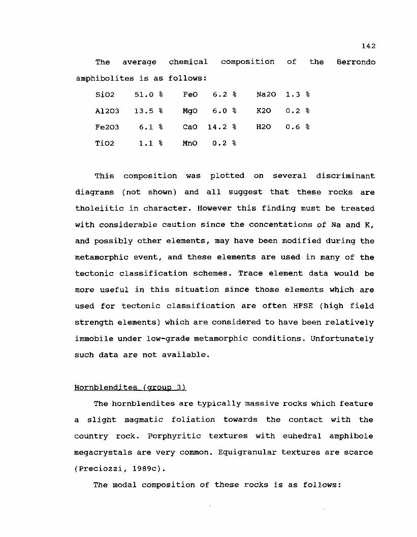
142
The average chemical composition of the Berrondo
amphibolites is as follows:
SiO2 51.0 % FeO 6.2 % Na20 1.3 %
A12O3 13.5 % MgO 6.0 % K2O 0.2 %
Fe2O3 6.1 % CaO 14.2 % H2O 0.6 %
TiO2 1.1 % MnO 0.2 %
This composition was plotted on several discriminant
diagrams (not shown) and all suggest that these rocks are
tholeiitic in character. However this finding must be treated
with considerable caution since the concentations of Na and K,
and possibly other elements, may have been modified during the
metamorphic event, and these elements are used in many of the
tectonic classification schemes. Trace element data would be
more useful in this situation since those elements which are
used for tectonic classification are often HFSE (high field
strength elements) which are considered to have been relatively
immobile under low-grade metamorphic conditions. Unfortunately
such data are not available.
Hornblendites (group 3)
The hornblendites are typically massive rocks which feature
a slight magraatic foliation towards the contact with the
country rock. Porphyritic textures with euhedral amphibole
megacrystals are very common. Equigranular textures are scarce
(Preciozzi, 1989c).
The modal composition of these rocks is as follows:

143
amphibole 50-60 % augite 8-2 %
andesine 24-14 % pistacite 3-1 %
quartz 12- 4 % microcline 0-4 %
Several features of these rocks are described in some
detail below because they appear to be relatively rare, not
only in southern Uruguay but around the world.
Two different generations of hornblende crystals can be
recognized based on textural and morphological features:
subhedral crystals with bluish pleochroism and euhedral
crystals with green pleochroisra. The optical characteristics of
these two types of amphibole are quite different.
Plagioclase with An 52-56 has been partially altered to a
fine-grained intergrowth of pistacite-clinozoisite. Microcline
and quartz are interstitial while, sphene, apatite, epidote and
opaques are the main accessory phases.
The primary pyroxene (augite) has been partially replaced
by a green amphibole with the same cleavage traces. Pyroxene
inclusions or relicts are common within the amphibole crystals.
A primary origin for the blue amphibole can also be deduced
from pétrographie observations.
Preliminary electron microprobe data show that both the
blue and green amphiboles are relatively magnesian, (Preciozzi,
1989c). A magmatic origin, in which pyroxene phenocrysts were
partially replaced by magmatic reaction to form two generations
of amphibole, seems to be the most reasonable explanation for
this unit.

144
Numerous outcrops of this group of rocks were identified in
the Piedra Alta Terrane, particularily in the Marincho and
Chamanga areas (Department of Flores) and in the Isla Mala
complex (Department of Florida).
Gabbros (group 4)
Members of this unit have been described from 3 localities
(Arroyo de la Virgen, Mahoma and Cerros Negros), all located in
Department of San José.
At Arroyo de la Virgen. bedding structures have been
preserved within the gabbro, which is cross cut by a set of
microgranite dykes. Deuteric alteration is more evident near
the margin of the mass, generating intense uralitization and
saussuritization of the component mineral.
The Arroyo Mahoma intrusion is shown in Figure III.21. This
intrusion also features compositional layering. The layers dip
at a pronounced angle, thereby allowing the observation of
different lithologies. Oyantçabal et al. (1990) and Villar and
Segal (1990) presented abundant pétrographie data for this
stock. The main texture is medium-grained, typically cumulus,
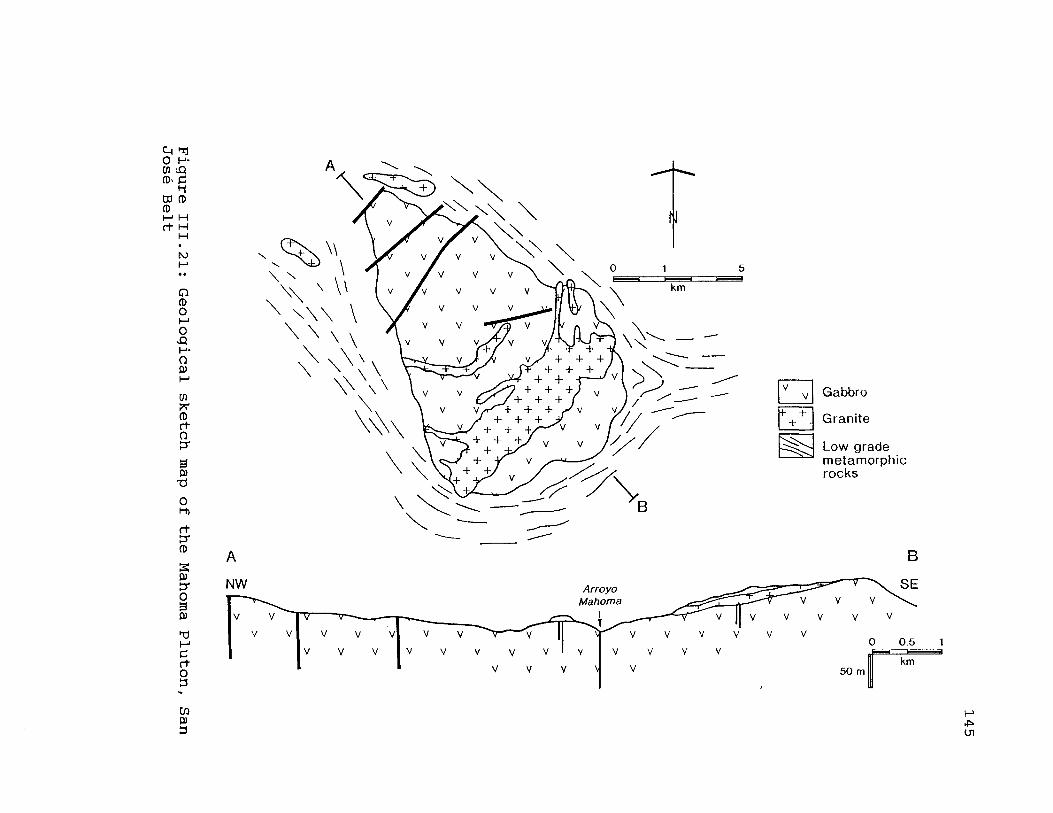
| )O H-cn si
DO (D
M Hrf- H
O(DO
)H-
oCD
en
(DrtO
0)13
OM)
rt
(D
S0)ITO3
drtO
Gabbro
Granite
Low grademetamorphicrocks
en3 Ol

146
and may or may not contain olivine. Plagioclase, normally a
cumulus mineral in this intrusion, ranges in composition
between An 55-65. Orthopyroxene, the composition of which
ranges between En 50-75 (hyperstene-eulite) is also cumulus in
nature and contains laminar exolutions of clinopyroxene.
Primary post-cumulus amphibole with brownish-green to brown
pleochroism and secondary amphibole with green pleochroism,
were observed. According to these authors, this intrusion has
undergone a slight differentiation. Primary hornblende
throughout the mass would indicate a minimal pressure of 2 Kb
at the roof of the intrusion (depth not less than 6 km.)
Villar and Segal (1990) proposed that the Cerros Negros
gabbro/anorthosites suite was emplaced into upper crustal rocks
during the Transamazonic event, before intrusion of the Mahoma
granite and the related pegmatitic microgranitic dykes.
Oyantçabal et al. (1990) have given a radiometric age of 2033
± 44 Ma (K/Ar on plagioclase) for this gabbro.
Mafic dyke swarm (group 5)
The mafic dyke swarm (Bossi and Campai, 1991) is found
exclusively in the Piedra Alta Terrane. Rocks which
collectively constitute the swarm are unknown east of the
Sarandi del Yi-Piriapolis lineament. This lineament is thus
proposed here as the eastern limit of the terrane. Members of
this swarm have not been recognized either in the Arroyo Grande
nor in the Montevideo belts (Figure III.22).

147
The gabbro-diorite dyke swarm displays a constant ENE
structural trend with a mean strike direction of approximately
N 70E. The width of the swarm is 150 km. as measured
perpendicular (N 20W) to the mean trend. The eastern edge of
the swarm has been subjected to a southward displacement for
about 40 km, and as a result, dykes have been flexured in a
simple shear regime which becomes more intense eastwards.
Most dykes are more than 1 km in length. The most common
length is about 5 km, but they range up to 26 km. Dyke
thicknesses range from 2 to 50 m. The thickness is practically
constant along the dyke, and decrases only at the extremities
of these intrusions. The walls are planar and parallel. In
quarries, and other localities where the topography permits
them to be observed easily, it is clear that they are
subvertical but rarely they can dip up to 70 to the south.
Longitudinal discontinuities of dykes can be related to: a)
progressive thinning, b) dyke coalescence, or c) faulting at
some orientation oblique to the trend of the dyke.
Geochemical data shows that there are two different groups
of dykes, namely andésites and basaltic andésites (Bossi et
al., 1990). The R1-R2 diagram of LaRoche (1980) shows the
distribution of the samples (Figure III.23). Group A dykes
(basaltic andésites) show "mg" values (MgO/ MgO + FeO), ranging
from 0.25 to 0.31 whereas group B dykes have both higher "mg"
values as well as a greater variation of "mg11 than Group A:
(0.40 to 0.56). Such differences indicate distinct stages of

148(0
Figure III.22: Distribution of late basic dykes in the PiedraAlta Terrane. After Bossi et al., (1993).

149
1500 -
1000
ALKALI� BASALT y
LATIBASALT
- LATITE
L
\
TRANSITIONAL yBASALT y
/ BASALTIC/ ANDESITE
LATI- \ * �ANDESITE \ . � 1
THOLEIITICBASALT
{
��-
BO Oo
o
ANDESITE
oo
�
1500 2000 2500
A � High Ti dykes B O Low Ti dykes
Figure III.23: R1-R2 classification diagram for the late dykeswarm, showing the presence of two distinct groups of basicdykes. After Bossi et al., (1993).

150
magmatic evolution which are closely related to the variable
TiO2 and incompatible element contents. The TiO2 content has
been used simply by itself to distinguish between the two
geochemical groups of mafic dykes, (Piccirillo and Melfi,
1988). The grouping arrived at by this method coincides with
that arrived at based on pétrographie considerations and is as
follows:
A) High titanium rocks, with weight percentage of TiO2 between
1.5% and 2.4%.
B) Low titanium rocks with weight percentage of TiO2 less than
1.05%.
Both groups of dykes also have important differences in trace
element concentrations, suggesting origins from melts of
different compositions. These two groups are closely associated
in the field, however definitive cross-cutting relationships
have not been observed to date.
Campai and Garat (1990) have carried out a detailed
pétrographie study of the dykes, both qualitative and
quantitative. The dykes are holocrystalline, with plagioclase
and pyroxene as the dominant minerals. Also present are
essential or accesory quartz - feldspar intergrowths
(micropegmatite) and opaques. The accessory minerals are
apatite, amphibole and biotite. The most common texture is
subophitic. Grain size of mafic rocks ranges from 0.1 mm. to
2.0 mm. in samples from the centre of the dyke.
Pétrographie features (Table III.5) indicate the presence of
two different petrologic groups.

151
The composition of the plagioclase crystals changes from
core to rim (composition ranging from An 42 to An 65) and there
are two compositional modes (An 45 and An 52-54) corresponding
to the two groups. The main pyroxene is a non pleochroic
subcalcic augite. In samples of Group B, orthopyroxene
constitutes at least 10 % of the total amount of pyroxene. They
are classified as "bronzite" based on their optical properties.
Opaque minerals are magnetite, ilmenite, pyrite and
chalcopyrite, the last two representing just 5 % of the total
volume of opaque phases. Intergrowths of magnetite and ilmenite
occur, forming equidimensional euhedral to subeuhedral
crystals. This kind of intergrowth is common in Group A and is
situated within the pyroxene. Skeletal ilmenite is dominant in
Group B.
Pyroxene-amphibole transformation (uralite) and biotite
have been observed in rocks of Group A. Long, thin crystals of
apatite, associated with micropegmatite, are always present.
These dimensional relations of crystals, suggest a fast
cooling, in accordance with their setting conditions.
Umpierre and Halpern (1971) originally determined whole-rock
K/Ar ages of 1580 and 1640 Ma on two of the dykes. Gomez Rifas
(1988) obtained K/Ar (whole-rock) ages of 1600 and 1400 Ma
Teixeira (in Bossi et al., 1990) obtained two K/Ar biotite ages
of 1790 Ma and 1830 Ma for samples taken at the contact between

152
TABLE III.5
PETROGRAPHIC CHARACTERISTICS OF THE TWO GROUPS OF MAFIC DYKES
CRITERION GROUP A GROUP B
plagioclase nucleus An 42-An50 An52-An64
plagioclase (vol %) 35 - 43 47 - 56
micropegmatite (vol %) 1 5 - 2 6 2 - 1 0
opaques ( vol%) 5 - 1 0 2 - 5
opaque shape cubic like skeletal
opaque type magnetite-ilmenite ilmenite
orthopyroxene not present rare
153
the host rock and the microgabbro dykes. Based on the probably
better Ar retentivity of the biotite than the whole rocks, this
author believes that the 1.8 Ga. age represents the approximate
age of development of the thermal contact phenomenon due to
dyke intrusion. An age of 1860 ± 120 ma (Rb/Sr method, whole
rock isochron) was obtained for several dykes with an 87Sr/86Sr
initial ratio of 0.7031 (Bossi et al., 1990). Recent 39Ar/40Ar
determinations by P.Renne (pers. com.) have yielded an age of
1790 ± 10 ma. The Sr isotope evidence combined with geochemical
data suggest that the dykes are derived from a slightly
enriched mantle or that they have a minor crustal
contamination.
The nature and geometric relations of this dyke swarm
suggest a regional extensional episode during the Statherian
period which was related to the stabilization (cratonization)
of the Piedra Alta Terrain. It is possible that the crustal
thinning and lithospheric thickening proposed by Introcaso and
Huerta (1982) are related to this extensional event.
TECTONICS
In this section we will only describe the most important
structural features recognized in the Piedra Alta Terrane. The
effects of successive deformations can be more easily studied
within the metamorphic belts than in the granite-gneiss
complex. In fact, when So is still identifiable, an indicator
of the original spatial position is available. In brief, the
analysis of the different tectonic phases affecting all the

154
rocks of the area, based on the observed deformations within
these belts, suggest that all the component regions of the
terrane (the metamorphic belts as well as the gneissic
terranes) have experienced an identical or similar evolution.
At present, geochronological data do not enable the age of the
metamorphic events to be established precisely within the
belts, because all the available data record the age of
crystallization of the magmatic rocks.
The San José Belt (mainly low grade metamorphic rocks) was
first deformed into regionally continuous E-W folds. À second
period of deformation, of major importance, overprinted the
early E-W tectonic grain of this belt, either breaking it up
into discrete units limited by faults in the western portion of
the belt (Department of Colonia) or generating a plastic
deformation as in the Department of San José (see Figure
III.13). Medium and low-grade lithologies as well as tectonic
contacts between them, were all affected by this later phase of
deformation, and therefore the discontinuities are older than
this phase.
A tectonic phase which overprinted the different grades of
metamorphic rocks was subsequently recognized. This phase
occupies an intermediate stratigraphie position between
metamorphism and associated folding (the first deformation
mentioned above) and the second phase related to the flexure
and segmentation of the belts. The granite-gneissic complex and
the San José belt are also separated by tectonic limits, in
this paper assigned to the same phase.
155
Similar structures can be detected (with difficulty) in the
granite-gneiss complexes. In these areas, gneissic peraluminous
granites are present which are of an enlongated shape (see
Figure III.8). The available data indicate a similar tectonic
evolution for the granite-gneiss complex and the Arroyo Grande
and San José belts, at least with respect to the two main
tectonic phases of deformation referred to above. An
extrapolation of this kind of deformation across the whole
Terrane seems to be reasonable.
Granitic bodies associated with the San José belt can be
divided in two main categories, based on the observed plastic
deformation. Two typical examples will be considered, the Isla
Mala granodiorite and the Mahoma granite. The first one shows
intrusive relations with low-grade metamorphic rocks along its
southern margin whereas progressive deformation and concordant
structures are developed along the north side of the intrusion
where it is in contact with the granite-gneiss complex. On the
other hand, the Mahoma granite is clearly post-tectonic,
without any evidence of having experienced plastic deformation.
Although a similar evolution for the granite-gneiss
complexes and the metamorphic belts may be accepted, at least
for the two last tectonic phases, based on the available data,
the origin and early history of the granite-gneiss complexes
remains obscure. These rocks may be primitive basement which
experienced a complex evolution and metamorphism which attained
anatectic conditions during the last tectono-thermal event
(Transamazonian event).

156
Summary of Pertinent Data for the Model
If the Piedra Alta Terrane may be considered as a tectono-
stratigraphic unit, then a model for the geological events
determining its whole architecture may be tentatively proposed.
A Transamazonian age for the main deformational phenomena
was the preferred model for the area prior to 1986. The
presence of granitic pebbles in meta-conglomerates of Arroyo
Grande Belt (Ferrando and Fernandez, 1971) argued in favour of
the existence of older basement in the area. Nevertheless, its
geometry and the location of this old basement were unknown.
Recently obtained isotopic age data (some of which were
presented in chapters 1 and 2) for a number of intrusive bodies
emplaced into the San José and Arroyo Grande metamorphic belts
now clearly indicate that the metamorphism and main folding
events are pre-Transamazonian in age.
Consequently any tectonic model for the Piedra Alta Terrane
must take into account the following facts:
1) Existence of 2500 ma magmatic rocks intruding the
metamorphic belts
2) Granitic bodies intruding these metamorphic belts as well as
the adjacent granite-gneiss complexes having Transamazonian
radiometric ages (2000 ma).
3) Some intermediate radiometric ages showing isochrons with
highly scattered data points.
4) Existence of structures which suggest the tectono-thermal
evolution originally proposed by Campai (1990), namely:

157
a) E-W trending structures with plastic tight folding
associated with the main metamorphic episode.
b) thrust structures superimposed on folded metamorphic
rocks.
c) a late stage of open folding which caused a NW trending
reorientation of the main foliation direction of the San José
belt.
Pre-Transamazonian ages obtained from some intrusive
granitoids suggest that the metamorphism of the San José and
Arroyo Grande belts occurred either in the very early
Proterozoic or possibly in the upper Archean.
Available geochronological data supporting the existence of
at least two domains, are presented in Figure III.24. Between
the pre-Transamazonian ages (greater than 2300 Ma) and
Transamazonian ones (1900-2100 Ma), a third group of
intermediate radiometric ages can be recognized.
The first group, in the 2400-2500 Ma range, corresponds to
the Isla Mala granodiorite. The granitic blocks inside the Paso
de Lugo Fault have Archean ages (2544 and 2501 Ma).
The second group (2100-2300 Ma) corresponds to the Marincho
granodiorite, the Isla Mala and Arroyo de la Virgen
leucogranites, to the other lithologies associated with the

158
ILU
ËgCO<£0
XLU
Û.
OOcoçoLUzoLU
ocLU
ZLUO
OCO<
oOLU
ÛC<LUCCOCCÛ<
<
O<
LU
mLUCO
oz<co
3<<LU
ÛÇ>
§CE
<
<Z
il<oCOQ<
ZoNnilceI -
LUCCC L
4 00
1
900
1000
CM
1
100
CM
I
200
CM
I
300
CM CM CM
CO
2
Figure III. 24: Suminary of the available radiometric age datafor rocks of the Piedra Alta Terrane
159
Marincho complex, and to the southern portion of the granite-
gneissic complex: Carreta Quemada, Pueblo Gonzales and the
migmatites of the AFE quarries (near the town of Suarez).
The third group (1900-2100) is clearly related to
Transamazonian granitic activity: Àrroyo de la Virgen, Isla
Mala and Marincho late dykes; Marincho leucogranite; Cerro
Colorado (Department of Florida), Cerros de San Juan
(Department of Colonia) and Mahoma (Department of San José)
granites.
In the granitic-gneiss complex a group of intermediate ages
have been determined which have large uncertainties.
Considering that the Transamazonian event could thermically
affect the primary age of pre-existing rocks (opening the Rb/Sr
system for some of the component minerals), the large
uncertainties are not in factsurprising and the whole rock ages
obtained from these rocks should be viewed with caution. The
youngest values obtained, considering the error interval,
suggest that these ages might be syn-tectonic to the last
tectono-thermal event.
The Proposed Model
The above data can be integrated into a model which applies
to at least the SJB and the AGB, and which consists of the
following sequence of events:
1) development of an "old" cratonic basement somewhere in the
area. Evidence favouring such a basement includes the very high

160
initial ratio of the 1969 Ma dykes which are intrusive into the
Marincho Complex (0.737) which can only have been derived by
partial melting of much older upper crustal material. Also
considered significant is the presence of cobbles of granitic
material within the meta-conglomerates of the AGB. The source
of these cobbles, and the location of the presumed old
basement, remain unknown. Cordani et al. (1988) have suggested
that, in Brazil, there exist two preponderant ages of older
rocks, one of approximately 2700 Ma and another at
approximately 3100 Ma. However these rocks are located to the
north of the area considered here, and there is no evidence to
suggest that the rocks that yield these ages are in any way
representative of the hypothetical "old basement" of Uruguay.
2) development of the two volcano-sedimentary sequences (the
SJB and the AGB). Metamorphism of these rocks to greenschist
faciès conditions. These metamorphic belts are dominated by the
presence of mafic volcanic rocks, suggesting some similarity,
possibly only superficial, to Archean greenstone belts in other
parts of the world.
3) emplacement of at least one syn-tectonic granitoid intrusion
(the main portion of the Marincho Complex) which does not
appear to have been deformed but most certainly has been
altered, sometimes rather strongly. The age of this intrusion
is approximately 2450 Ma. There exists several "older" plutonic

161
bodies (Feliciano and Yi granites - age unknown) which have
clearly been deformed.
It must be noted that this sequence of events is VERY
similar to that recognized in the Abitibi area of Quebec (see
discusion in chapter 2 ) . Thus, by analogy, it is reasonable to
suggest that the age of the plutonic rocks may by only slightly
younger than the age of the metamorphic belts themselves.
Carrying the anology further, it is possible that the lens-
shaped distribution of rock types observed here is analogous to
those observed in the Abitibi Belt. Such a lens-shaped
distribution can form as a result of oblique subduction
(Sylvester, 1988).
4) emplacement of the major portion of the plutonic granitoid
rocks which are situated WITHIN the metamorphic belts. The age
of these plutons range from approximately 2300 MA to 2200 Ma.
The older of these intrusions have a chemistry suggestive of a
syn-tectonic environment of emplacement, whereas the younger
intrusions have a post-tectonic chemistry.
5) tectonic juxtaposition of all the above rocks with areas of
high-grade granitic gneisses and migmatites. The contact
between these two major assemblages of rocks are major fault
zones with significant mylonite development. Numerous Rb-Sr age
determinations on the gneissic rocks suggest that the
metamorphism occurred between 2200 Ma and 2000 Ma - an event

162
known as the Transamazonian orogeny. The primary age of the
gneisses is not known. The tectonic juxtaposition must have
occurred after the metamorphism of the gneisses was completed
and the gneisses has cooled to some extent - otherwise the
greenschist faciès mineral assemblages in the "greenstone-like"
metamorphic belts would not have been preserved. The elongated
(oblong) shape and massive texture of the Arroyo Grande Pluton,
which was emplaced into one of the major fault zones and which
has been dated at 1969 Ma, suggests that tectonic assembly had
been completed by this time (ie during Transamazonian time)
6) emplacement of a number of granitoid dyke rocks into the
pre-existing plutons. Available Rb-Sr age data suggest that
these dykes are post-Transamazonian, ranging in age from 1900
Ma to 2050 Ma. The chemistry of these rocks is variable,
however some are clearly Fe-rich post-orogenic rocks. As yet,
these dykes have not been observed in the gneissic rocks
7) emplacement of a mafic dyke swarm into both the metamorphic
belts and the gneissic rocks. These mafic dykes have been dated
by several different methods and have yielded a variety of
ages, however the author believes that the most reasonable for
the age of intrusion is approximately 1800 Ma.
8) development of a major fault zone (the Sarandi del Yi -
Piriapolis Lineament) along the eastern margin of the Piedra
Alta Terrane, separating it from the adjacent Nico Perez
163
Terrane. The mafic dyke swarm is not present in the Nico Perez
Terrane, thereby indicating that the tectonic activity which
juxtaposed these two terranes is post-dyke (post 1800 Ma) in
age.
The relationship of the Montevideo Belt
The Montevideo belt represents the only assemblage that
could have been metamorphosed during the Transamazonic orogeny
only, but the absence of geochronological data in the
metamorphic rocks makes this statement speculative. The age of
the muscovite pegmatites of Arroyo Pando and 101 Road range
between 1900-2100 Ma, (Hart, 1966) and are consistent with a
Transamazonian age, however this should not be considered as
definitive because the relationship of the dated material to
the Montevideo belt as a whole is not clear. Campai (pers.
comm) thinks that this type of pegmatite is genetically related
to the "S" type granite injections which are found in the
Mosquitos Formation. Thus, with the possible exception of this
belt (with a doubtful age) it can be definitely stated that
supracrustal rocks of Transamazonian age have not yet been
recognized within the Piedra Alta Terrane.
164
Possible correlations on a larger scale
Other areas of either Archaean or Early Proterozoic rocks
have been identified in the southern portion of South America,
however their relationship to the Piedra Alta Terrane is
largely speculative.
The Tandilia region of Argentina is the centre of a long
sliver of Proterozoic rocks which is approximately 400 km in
length and 50 km in width, (see Figure III.25). The centre of
this band of rocks is located about 400 km southwest of
Montevideo. Dalla Salda et al. (1988) suggest that the Piedra
Alta Terrane and the Tandilia rocks have numerous features in
common, including the age and nature of the plutonic rocks, the
metamorphic grade of the host gneisses and the orientation and
sequence of development of the observed structures. For this
reason, they propose that the rocks of the two areas form a
common geotectonic unit. However Ramos (1988) proposes the
presence of suture zone along the northern margin of the
Tandilia rocks (see Figure III.25), thereby casting doubt on
the validity of this correlation.
The fact that the mafic dyke swarm mentioned above is not
found east of the Sarandi del Yi - Piriapolis Lineament clearly
shows that the Nico Perez Terrane evolved independently of the
Piedra Alta Terrane in spite of their superficial similarities.
Therefore the Piedra Alta Terrane can only be correlated with
rocks which are located to the west of this fault zone. The
closest rocks to the north of the Piedra Alta Terrane which

165
AMAZONIAN CRATON
/ � � ; . � PARAGUAYTo
o . ;i o -.Paraguay Oriental \
o
ChaftaralDisplaced Terrane
o o I Cenczoic cover
\Q �I Allochthonous Terrones
\\ � / I Displaced Terranes
I � * I Exotic Terranes
Suspect Terranes
I . ' . ' .1 pre-Brasihono blocks
Parana' Basin
Ultramafic and mafic suites
Vergence of main deformaîion
Magma tic axis
A Late Paleozoic
+ Early Paleozoic
X Lote Proterozoic
Axis of extension
Subsurface data
Inferred suture zones
� * � Late Paleozoic
Early Paleozoic
Late Proterozoic
Older sutures
- Malvinas Plateau
Figure III.25) Main cratonic blocks and allochthonous terranesof southern South America. Horizontal lines indicate the extentof the Alto Paraguay Terrane (after Ramos, 1988).

166
satisfy this requirement are located 1000 km north of
Montevideo in eastern Paraguay (the Paraguay Oriental
exposures), the intervening area being covered by younger
rocks. The Paraguay Oriental rocks may themselves belong to the
much larger Amazonian Craton which is located even further
north in Brazil, however this also is speculative, since the
area between these two is also covered by younger material.
Thus, for the moment, the Piedra Alta Terrane must be
considered as an entity unto itself, not demonstrably related
to any other Precambrian rocks of South America. Porada (1989
and earlier papers) has written extensively on the striking
similarity between the Precambrian rocks of southern Africa and
those discussed above. He has proposed that a large area of
Precambrian rocks, with underwent a complicated geotectonic
evolution, was fragmented at approximately 1000 Ma only
to undergo continental collision and reassembly at
approximately 600 Ma (the Brasilian orogeny). While this may be
a useful model on a grand scale, it has been emphasized above
that even the South American portion of this larger area of
Precambrian rocks consists of a number of terranes which are
distinct either because of the lithology, metamorphic grade or
structural orientation of the observed units or because of the
age of the deformation. This hypothesis must therefore be
continuously revaluated, and possibly modified, as more
information becomes available and as the relationship between
the different areas of Precambrian rocks of southern South
America, and adjacent Africa, become better understood.

167
Closing Comment
Finally the author offers a closing comment concerning the
apparent absence of Lower Proterozoic volcano-sedimentary belts
in the area described above. Three hypotheses can be proposed
to explain this observation:
1) No such volcano-sedimentary basins developed in the
interdomain period (2500-2100 Ma) in the Piedra Alta Terrane.
2) The Piedra Alta Terrane originally contained such rocks, but
they were subsequently completely eroded - in spite of the
preservation of low-grade supracrustals rocks of the pre-
Transamazonian domain.
3) The rocks are in fact present but they have not yet been
recognized at the present.
Additional geological and geochronological information,
which hopefully will become available in the next few years,
will enable meaningful choices between these alternatives (or
possibly other alternatives as yet unenvisaged) to be made, and
in addition should shed some light on the nature, age and
regional significance of the Transamazonian orogeny in Uruguay.

168
Conclusions
The three periods of intrusion of granitoid rock discussed
in chapters 1 and 2 are consistent with a model involving two
distinct periods of orogenic activity.
1) The first orogenic episode is of Archean age (earlier than
2544 Ma) and is associated with the development of the volcano-
sedimentary belts and the deformed plutons located within them.
2) The second orogenic episode is of Early Proterozoic age
(2290 - 2180 Ma) and is associated with the emplacement of most
of the massive granitoid rocks described in the report. At
approximately the same time, the area underwent a tectonic
assembly - different blocks of crustal material, of different
metamorphic grade and possibly different primary age, were
welded together to form the Piedra Alta Terrane. This episode
is considered to be the Transamazonian orogeny. The relationsip
between the timing of metamorphism in the granitic gneisses and
the intrusion of the granitoids is not clear and will require
additional age determinations.
3) A number of granitic dykes and small intrusions were
emplaced into the pre-existing granitic rocks between 2040 Ma
and 1894 Ma. They are either very late Transamazonian or
possibly post-Transamazonian.
4) The whole area was intruded by a swarm of gabbroic dykes at
approximately 1800 Ma. They are undeformed and unmetamorphosed
- therefore the Transamazonian event had definitately ended by
this time.

169
REFERENCES
Ailling, H.L., 1938. Plutonic perthites. Journal of Geology 46:142-165.
Almeida, F.F.M. de, 1973. Geochronological division of thePrecambrian of South America. Revista Brasiliera de Geociencias1: 13-21.
Almeida, F.F.M. de, Amaral, G., Cordani, V.G. and Kawashita,K., 1976. The precambrian evolution of the South Americancratonic margin. IN; Nairn and Stehli, editors. The oceanicbasin and margins. Plenum Press, New York. 1411-1446.
Andreis, R. y Mazzoni, M., 1967. Sedimentologia de lasformaciones Kiyû y San José. Revista del Museo, La Plata,Argentina: Geologia 4: 41-96.
Batchelor, R.A., and Bowden, P., 1985. Petrogeneticinterpretation of granitoid rock series using multicationicparameters. Chemical Geology 48: 43-55.
Bossi, J., 1978. Recursos minérales del Uruguay. Aljanati,Montevideo, Uruguay.
Bossi, J., 1983. Breve resena sobre el conocimiento geolôgicodes Escudo Predevoniano en Uruguay (Sud America). Zentralblattfur Géologie und Palâontoloaie 417-429.
Bossi, J., 1989. Recientes avances sobre la geologia delCinturôn Orogénico Moderno (1000 - 500 M.A.) en Uruguay.Boletin Invest. Facultad de Agronomia, Universidad de laRepûblica. Montevideo. Uruguay. 20: 1-24.
Bossi, J. y Campai, N., 1991. Granitos negros filianos delUruguay: resultados de los investigaciones. Ediciôn de laFacultad de Agronomia. Universidad de la Repûblica. Montevideo,Uruguay. 72 p.
Bossi, J., Campai, N., Civetta, L., Demarchi, G., Girardi,V.A.V., Mazzucchelli, M., Picirillo, M., Rivalenti, G.,Sinigoi, S. and Texeira, W. , 1990. Petrological andgeochronological aspects of the Precambrian mafic dyke swarmf rom Uruguay. Second International Dyke Swarm Symposium,Adelaide. Australia.

170
Bossi, J., Fernandez, N. y Elizalde, G., 1965. Predevoniano delUruguay. Boletin 78: Facultad de Agronomia. Universidad de laRepublica,. Montevideo. Uruguay.
Bossi, J. , Ferrando, L., Fernandez, N., Elizalde, G. , Morales,H. , Ledesma, J.J., Carballo, E., Medina, E. , Ford, I. yMontana, J., 1975. Carta geolôgica del Uruguay a escala 1:1 000000. Ediciôn de los autores.
Bossi, J. y Navarro, R., 1987. Esquema preliminar sobre laevoluciôn geolôgica del Uruguay durante el perïodo Câmbrico.Actas X Congreso Geolôgico Araentino. 1: 346-350.
Bossi, J. y Navarro, R. , 1991. Geologia del Uruguay. Edicion dela Universidad de la Republica. Montevideo, Uruguay.f 961 p.
Bossi, J. , Preciozzi, F. y Campai, N., (1993). El Predevonianoen el Uruguay. Direcciôn Nacional de Mineria y GeologiaP
Ministerio de Industria, Eneraia y Mineria del UruguayP
Montevideo, Uruguay. 70 p.
Campai, N., 1990. Aportes al conocimiento de la estratigrafiadurante el Precâmbrio Medio del Uruguay (con émfasis en losDepartmentos de Florida y San José. Congreso Uruguayo deGeologia l: 65-69.
Campai, N. y Chulepin, H., 199i. Carta geolôgica del Uruguay aescala de 1:100 000: Fotoplano Talita. Direcciôn Nacional deMineria y Geologia. Ministerio de IndustriaP Energia y Mineriadel Uruguay, Montevideo, Uruguay.
Campai, N. y Garât, I., 1990. Consecuencias petrolôgicas de lasvariaciones composicionales dentro del haz de filones mâficosprecambrianos del centro-sur del Uruguay. Proyecto IGCP 257:Workshop #2 - Digues maficos do Brasil. Sao Paulo. Brasil. 99-109.
Campai. N. , Oyhantcabal, P., Bachmann, I. y Galmarini, G.,1988. La faja milonitica de los Cerros Mosquitos. Acta IReunion de la Geologia del Uruguay. Salto. 101-103.
Card, K.D., 1990. A review of the Superior Province of theCanadian Shield, a product of Archean accretion. PrecambrianResearch 48: 99-156.
Cardellino, R. y Ferrando, L. , 1969. Carta geolôgica delUruguay a escala 1:100 000: sector XCVIII. Boletin 2:Departamento de Publicaciones. Universidad de la Republica.

171
Cingolani, C., Bossi, J. , Varela, R. y Navarro, R., 1990. Nuevodatos geolôgicas y geocronôlogicos des macizo granitico deCerro Colorado, Florida, Uruguay. Acta I Conareso Geoloaico delUruguay, 101-105.
Clarke, D. , 1990. NEWPET. (computer program). Department ofEarth Sciences, Memorial University of Newfoundland.
Coney, P.J., Jones, D.L., and Monger, J.W.H., 1980. Cordilleransuspect terranes. Nature 288: 329-333.
Coronel, N. y Oyhantçabal, P., 1988. Carta geolôgica delUruguay a escala 1:100 000: Fotoplano Pando. DireccionNacional de Mineria y Geologia. Ministerio de Industria.Enerqia y Mineria del Uruguay. Montevideo, Uruguay.
Cordani, V. y Soliani, E., 1990. Idades K-Ar e Rb-Sr das "UnasCristalinas" de Rivera e Acegua (Uruguai e Rio Grande do Sul)e seu enquadramento no contexto geotectonico regional. An.Acad. Bras. Cien.. 62: 145-156.
Cordani, U.G., Teixeira, W., Tassinari, C.C.G., Kawashita, K.and Sato, K., 1988. The growth of the Brazilian Shield.Episodes f 11: 163-167.
Cox, K,G., Bell, J.D. and Pankhurst, R.J., 1979. Theinterpretation of igneous rocks. Allen and Unwin Ltd., London,UK, (450 pp).
Dalla Salda, L., Bossi, J. and Cingolani, C , 1988. The Rio dela Plata cratonic region of southwestern Gondwanaland.Episodes, 11: 263-269.
Davidson, A., Culshaw, N.G., and Nadeau, L., 1982. A tectono-metamorphic framework for part of the Grenville Province,Ontario. Geological Survey of Canada Paper 82-1A: 175-190.
Debon, F., and LeFort, P., 1983. A chemical - mineralogicalclassification of common plutonic rocks and associations.Transactions of the Royal Society of Edinburgh 73: 135-149.
Deer, W.A., Howie, R.A., and Zussman, J. , 1966. Rock-formingminerals. Longmans, New York, 371 pp.
Ebadi, A., and Johannes, W. , 1991. Beginning of melting andcomposition of first melts in the system Qz-Ab-Or-H2O-CO2.Contributions to Mineralogy and Petrology 106: 286-295.
Fernandez, A.N. y Preciozzi, F., 1974. La formacic-n ArroyoGrande y los granitoides asociados. Annales. XXVIII CongresoBrasileiro de Geoloaia. 212-226.

172
Ferrando, L. y Fernande2, A.N., 1971. Esquema tectonicoestratigràfico del Predevoniano en el Uruguay. Annales. XXVConareso Brasileiro de Geoloaia. 199-210.
Feselfeldt, K., 1988. Cooperaciôn técnica proyecto 84.2024.2:Misiôn geoflsica alemana, asesormiento yacimentolôgico a laDireccion Nacional de Mineria y Geologia. unpublished report.
Fragoso-Cesar, R., Machado, R. y Gomez Rifas, C., 1987.Observaçoes sobre o conturao Dom Feliciano no escudo uruguaioe correlaçoes com o escudo do Rio Grande do Sul. Actas IIISimposio Sul-Brasileirono de Geoloaia. Curitiba, Brasil.
Francis, J.C. y Mones, A., 1965. Sobre el hallazgo deCardiatherium Talicei n. sp. en playa Kikû, Departmento de SanJosé, Uruguay. Kraaleviana 1: 3-44.
Garat, I., 1991. Carta geologica del Uruguay a escala 1:100000: Fotoplano Guaycurû. Direccion Nacional de Mineria yGeologiaP Ministerio de Industria, Energia v Mineria delUruguay, Montevideo, Uruguay.
Gabrielse, H., 1991. Late Paleozoic and Mesozoic terraneinteractions in north-central British Columbia. CanadianJournal of Earth Sciences 28: 947-957.
Gomez-Rifas, C , 1988. La edad de los microgabros negros delProterozoico medio del Uruguay. Actas I Reunion de Geoloaia delUruguay, Salto. 106-107.
Hart, S., 1966. Radiometric ages in Argentina and Uruguay andtheir implications concerning continental drift. Abstracts -Geological Society of America Annual Meeting.
Hervé, F. y Mpodozis, C. , 1991. Terrenos tectonoestratigràficosen evoluciôn de los Andes Chilenos - una revision.Comunicaciones 41: 67-72.
Holdaway, M.J., 1971. Stability of andalusite and thealuminosilicate phase diagram. American Journal of Science 271:97-131.
Introcaso, A. y Huerta, E., 1982. Interpretacion del exceso degravedad en Uruguay. Actas del V Congreso Latinoamericano deGeologia, Argentina: 87-104.
Irvine, T.N., and Baragar, W.R.A., 1971. A guide to thechemical classification of the common volcanic rocks. CanadianJournal of Earth Sciences 8: 523-548.

173
Lameyre, J. , 1987. Granites and evolution of the crust. RevistaBrasileira de Geociencias, 17: 349-359.
LaRoche, H. de, Leterrier, J. , Grandclaude, P., and Marchai,M., 1980. A classification of volcanic and plutonic rocks usingR1-R2 diagram and major element analyses. Its relationshipswith current nomenclature. Chemical Geology 29: 183-210.
Maniar, P.D., and Piccoli, P.M., 1989. Tectonic discriminationof granitoids. Geological Society of America Bulletin 101:635-643.
Mantovani, M.S.M. and Hawkesworth, C.J., 1990. An inversionapproach to assimilation and fractional crystallisationprocesses. Contributions to Mineralogy and Petrology, 105:290-302
Martin, R.F., and Bonin, B., 1976. Water and magma genesis: theassociation hypersolovus granite - subsolvus granite. CanadianMineralogist 14: 228-237.
Masquelin, H., 1990. Anàlisis estructural de las zonas decizalla en las migmatitas de Punta del Este, Uruguay. ActaGeologia Leopoldensia, 13(30): 139-158.
Mehnert, K.R., 1968. Migmatites and the origins of granite.Elsevier, Amsterdam.
Oyhantçabal, P., Medina, E. y Sportuno, J., 1990. Geologia ypetrografia del stock de gabro del Arroyo Mahoma. I CongresoUruguayo de Geologia, 115-122.
Paterson, S.R., Vernon, R.H., and Obisch, O.T., 1989. A reviewof criteria for the identification of magmatic and tectonicfoliations in granitoids. Journal of Structural Geology 11:349-363.
Piccirillo, E.M. and Melfi, A.J., 1988. The Mesozoic floodvolcanism of the Parana Basin: petrogenetic and geophysicalaspects. Unpublished manuscript, University of Sao Paulo,Brazil.
Porada, H., 1989. Pan-African rifting and orogenesis insouthern to equitorial Africa and eastern Brazil. PrecambrianResearch 44: 103-136.
Preciozzi, F. , 1989a. Estudio geoquimico del complejo intrusivode Isla Mala. Contribuciôn Geologia de Uruguay #6, DirecciônNacional de Mineria y Geologia. Ministerio de Industria,Energia v Mineria del Uruguay.
174
Preciozzi, 1989b. Aspectos petrogrâficos del complejo intrusivode Arroyo Marincho y granodiorita de Arroyo Grande.Contribuciôn Geolôgia de Uruguay #7. Direcciôn Nacional deMineria y Geologia. Ministerio de Industria. Energia y Mineriadel Uruguay.
Preciozzi, F., 1989c. Mineralogïa y geoquimica del complejointrusive de Arroyo Marincho y granodiorita de Arroyo Grande.Contribuciôn Geol6gia de Uruguay #8. Direcciôn Nacional deMineria y Geologia. Ministerio de Industria. Energia y Mineriadel Uruguay.
Preciozzi, F., 1989d. Estudio geoquimico del complejo intrusivodel Arroyo de la Virgen. Contribuciôn Geolôgia de Uruguay #9 fDirecciôn Nacional de Mineria y Geologia. Ministerio deIndustriaP Energia y Mineria del Uruguay.
Preciozzi, F., 1989e. Litoestratigrafia de la secuenciavolcanica sedimentaria del grupo Lavalleja, (Region Minas - Pande Azûcar), Uruguay. Contribuciones al Estudio de la Geologiadel Uruguay, Direcciôn Nacional de Mineria y Geologia f
Ministerio de Industria. Energia y Mineria del Uruguay. 2:1-24.
Preciozzi, F., 1989f. Aspectos estructurales de la secuenciavolcano-sedimentaria -del grupo Lavalleja, (Region Minas - Pande Azûcar), Uruguay. Contribuciones al Estudio de la Geologiadel Uruguayf Direcciôn Nacional de Mineria y Geologiaf
Ministerio de Industria. Energia y Mineria del Uruguay.1: 1-17.
Preciozzi, F., 1989g. Estudio petrogréphico y geoquimico de laregion Mal Abrigo - Cufré. Contribuciones al Estudio de laGeologia del Uruguay. Direcciôn Nacional de Mineria y GeologiaP
Ministerio de Industria, Energia y Mineria del Uruguay.5: 1-16.
Preciozzi, F., 1990. Geologia de los granitoides intrusivosasociados al cinturôn metamôrphica Paso Severino-Cerros de SanJuan. Direcciôn Nacional de Mineria y Geologia, Ministerio deIndustria, Energia y Mineria del Uruguay, 16 p.
Preciozzi, F., 1992. Aspectos geocronolôgicos del TerrenoPiedra Alta: una contribuciôn al estudio de la geologia delUruguay. Direcciôn Nacional de Mineria y Geologia, Ministeriode Industria. Energia y Mineria del Uruguay (unpublishedreport)
Preciozzi, F., Bossi, J. and Morales, H., 1991. The Uruguayancrystalline basement. IN: Global Geoscience Transect. ValparisoChile - Punte del Este, Uruguay. (C. Mpodozis, editor) 35 p.

175
Preciozzi, F., and Bourne, J.H., (1992). Petrography andgeochemistry of the Arroyo de la Virgen and Isla Mala Plutons,southern Uruguay, with a comment on tectonic implications forthe Transamazonian orogeny. Journal of South American EarthSciences.
Preciozzi, F., Sportuno, J. y Heinzen, W., 1979. Carta geo-estructural del Uruguay, a escala 1:2,000,000 y memoriaexplicativa. Direcciôn Nacional de Mineria y GeologiafMinisterio de Industria y Energia del Uruguay, 39 p.
Preciozzi, F., Spoturno, J., Heinzen, W., y Rossi, P., 1985.Memoria explicativa de la Carta Geolôgica del Uruguay a laescala 1:500.000. Direcciôn Nacional de Mineria y Geologia.Ministerio de Industria y Eneraia del Uruguay, 90 pp.
Ramos, V., 1988. Late Proterozoic - Early Paleozoic of SouthAmerica: a collisional history. Episodes, 11: 168-174.
Serra, N., 1945. Memoria explicativa del mapa geolôgico delDepartmento de Colonia. Instituto Geologico del Uruguay,Boletin 31.
Skippen, G.B., 1971. Experimental data for reactions insiliceous marbles. Journal of Geology. 70: 451-481.
Skippen, G.B., 1974. An experimental model for low pressuremetamorphism of siliceous dolomitic marbles. American Journalof Science. 274: 487-509.
Slaughter, J., Kerrick, D.M. and Wall, V.J., 1975. Experimentaland thermodynamic study of phase equilibria in the system CaO-MgO-SiO2-H2O-CO2. American Journal of Science, 275: 143-162.
Soliani, E. jr., 1986. Os dados geocronolôgicos do Escudo Sul -Rio Grandense e suas implicaçoes de ordem geotectônica.unpublished PhD thesis, Universidade de Sao Paulo
Streckeisen, A., 1976. To each plutonic rock its proper name.Earth Science Reviews 12: 1-33.
Sylvester, A.G. 1988. Strike-slip faults. Geological Society ofAmerica Bulletin. 100: 1666-1703.
Umpierre M., y Halpern, M., 1971. Edades estroncio-rubidio enrocas cristalinas del sur de la Republica Oriental del Uruguay.Revista de la Asociaciôn Geolôgica Argentina r 26: 133-155
Villar, L. y Segal, S., 1990. Caracterizaciôn petrolôgica ymetalogénica del complejo gâbroico proximo a San José de Mayo.San José, Uruguay. I Congreso Uruguayo de Geologia, 199-204.

176
Walther, K., 1948. El basamento cristalino del Departmento deMontevideo. Boletin del Instituto de Geoloaia, 33.
Will, T.M., Powell, R. , Holland, T. and Guiraud, M., 1990.Calculated greenschist faciès mineral equilibria in the systemCaO - FeO - MgO - A12O3 - SiO2 - CO2 - H20. Contributions toMineralogy and Petrology 104: 353-368.
Winkler, H.G.F., 1970. Petrogenesis des rocas metamorficas. H.Blume and Company, Madrid, 346 pp.
Winkler, H.G.F., 1979. Petrogenesis of the metamorphic rocks(fifth edition). Springer Verlag, New York, 348 p.
York, D., 1966. Least-squares fitting of a straight line.Canadian Journal of Physics, 44: 1079 - 1086.

177
APPENDIX 1
AN OVERVIEW OF THE PREDEVONIAN SHIELD OF URUGUAY

178
The Uruguayan crystalline basement may be subdivided in
three major structural provinces: Piedra Alta Terrane, the Nico
Perez Terrane and the Cuchilla Dionisio Belt (see Figure 1 ) .
The last two provinces belong to the Brasilian cycle sensu
Almeida (1973) because they contain lithostructural units which
were deformed during Late Proterozoic time, and also a number
of 500-700 Ma granitoid intrusions. The boundaries between
these provinces are major shear zones. Studies of kinematic
indicators in these shear zones reveal that the Nico Perez
Terrane moved southwards from its original position relative to
the other two provinces. The western shear zone with regional
trends N 10 W is called the Sarandi-Piriapolis lineament and
had a dextral movement over 40 kms. The eastern shear zone
contains syndeformational type "S" granites with subvertical
planar structures in the north and subhorizontal ones in the
south with vergence indicators to the SE. Basic and ultrabasic
rocks have been observed along this boundary.
PIEDRA ALTA TERRANE
This structural province (Bossi et al., 1993) is the
westernmost of the three and belongs to the Transamazonian
Cycle sensu Almeida (1973), This event, which in Uruguay has
previously been named the Ciclo Orogenico Antiguo after Bossi
(1983), has been renamed here as the Piedra Alta Terrane. A
synthesis of this unit was made by Campai (1990) who recognized
three deformation phases predating 2000 Ma followed by
cratonization during the Estaterian (1900 Ma) and the

179
development of an exceptionally intense microgabbro dyke swarm
during Calymmian times (1700 - 1800 Ma).
New radiometric data indicate that the age of the
intrusive leucogranites with ENE structures is 2290 ± 35 Ma
(initial ratio of 0.7113) using the Rb/Sr method on the whole
rock. Therefore it is reasonable to place the metamorphism near
the beginning of the Early Proterozoic.
Four different elements may be recognized in this terrane:
Arroyo Grande Belt, San José Belt, Montevideo Belt and the
Granitic-gneissic complex.
The Arroyo Grande Belt is located along the northwestern
margin of the Uruguayan Crystalline terrane, which forms the
basement of the Piedra Alta Terrane. The AGB consists of
greenschist f acies metasedimentary and metavolcanic rocks which
are exposed in a lozange-shaped area approximately 40 km in
length with a maximun width of 13 km. Detrital metasedimentary
rocks (with minor metavolcanic units) constitute the lower and
middle sections of the formation and are exposed along the
northern and central portions of the outcrop area of the AGB.
The metavolcanic rocks, the uppermost portion of the AGB, are
exposed along the southern margin of the lozange. Both rock
types typically have overall east-west strike. The Paso de Lugo
fault, a major structure of considerable linear continuity and
east- west orientation, forms the southern boundary of the
lonzage, separating it from granitic-gneisses and related

180
too
BuenosAires
58° 56°
Devonian to Quaternary cover
CUCHILLA DIONISIO BELT(low grade metamorphic rocks/granitoids)
A: Lavalleja GroupB: Rocha Group
NICO PEREZ TERRANEE: Valentines Formation
PIEDRA ALTA TERRANE
v v v
AtlanticOcean
Mobil belts associated to PiedraAlta Terrane
C: Arroyo Grande BeltD: San José BeltE: Montevideo Belt
Mesosilicic Cambrian magmatism
Main tectonic events1: Sierra Ballena Shear Zone2: Sarandi del Yi-Piriapolis lineament3: Limit NPT/CDB
Figure A-l: Geological sketch map of southern Uruguay, showingthe location of the different "terranes". After Preciozzi etal., (1991).

181
granitic rocks to the south. The Paso del Puerto fault forms
the northwestern boundary of the AGB. Several granitic bodies
have been intruded into AGB.
The San Jose Belt is an east-west trending belt consisting
of a low- to medium-grade volcano-sedimentary series. The
northern limit of the belt is a tectonic contact with
high-grade orthoamphibolites whereas in the south the rocks are
transformed into a sequence of amphibolites, gneisses amd
kyanite-sillimanite micashists. At least two demormational
phases have been recognized in this belt. The first phase, syn-
metamorphic, is folded about vertical axes whereas the second
generation of folds are of large amplitude and have a
horizontal axis. The second phase affected the late tectonic
2300 Ma granitoids and yet have controlled the emplacement of
a 2000 Ma gabbro-granitic-complex which are preferentially
located in the cores of these structures, (Mahoma, Guaycuru).
Some authors have interpreted these associations as
greenstone belts (Fragoso et al., 1987; Fesefeldt, 1988) of
possible Archean age, but the absence of komatiites and other
ultrabasic rocks, and the clear predominance of a non-pelagic
sedimentary sequence, argues against this hypothesis. The belt
really has the same lithologie and tectonic features as those
of the surrounding rocks, so it is preferable to consider them
as metamorphic relicts of a typical ensialic
volcano-sedimentary sequence.

182
The Montevideo Belt is a roughly west trending metamorphic
belt and it is situated along the extreme southern margin of
the Piedra Alta Terrane in the departments of Montevideo and
Canelones. The three main lithologies so far identified are:
oligoclase gneisses, amphibolites and micaschist. The
structural conformity and homogeneity of metamorphic faciès
were the main critria used to define this belt.
The granitic-gneissic complex (and related migmatites) is
exposed along both sides of the San José belt and consists
mainly of a series of foliated anatectic porphyritic granitoids
associated with different types of gneisses.
To the south of the San José belt, syntectonic granites
and migmatites have been dated at 2200-2300 Ma and are
contemporaneous with a number of late tectonic, shallow-level
intrusive granites ( eg. Isla Mala and Arroyo de la Virgen
plutons).
North of the San José belt, the granitoids and migmatites
have been dated at 2000 Ma. Campai (1990) demonstrated that
these gneisses have been affected by three periods of
deformation. Included in this unit are a number of intrusive
rocks, ranging from shallow intrusive gabbro-granitic complexs
(eg. Mahoma) to anatectic deep seated granites (Florida, Cerro
Colorado).
A very large swarm of microgabbro-diorite dykes is the
last manifestation of magmatic activity recorded in the Piedra
Alta Terrane. It consists of a large number of subparalell
dykes, trending N 60- 80 E, which range in length up to 20 kms

183
and are typically about 20 meters in width. Recent
geochronological studies have yielded values of about 1780 ± 30
Ma (K-Ar on biotite from the country rock where it is in
contact with the dyke). This E-W continuity of the swarm has
been interrupted by a N 10 W dextral shear zone known either as
the Sarandi del Yi fault (Preciozzi et al., 1979) or the
Sarandi del Yi lineament (Bossi and Navarro, 1987).
This regional mylonite zone ranges in width up to 15 km.
Within this zone, the rocks have been deformed to varying
degrees, and now range from cataclastites to ultramylonites.
Bands of intensive recrystallization are commonplace. Locally,
partial melting phenomena have been observed, generating lens
of rhyolite with euhedral beta quartz, implying temperatures
higher than 580°C at shallow depth. This lineament, which
played a major role during the evolution of the Uruguayan
Shield, may have been (re)activated a various times. Certain
recrystallization phenomena, which were probably related to the
latest movement within the belt, have been dated at 535 ± 15 Ma
(Rb-Sr whole rock values recalculated from the data of Umpierre
and Halpern, 1971). This date is from a mylonite located
southeast of the village of Nico Perez, the protolith of which
has dated at 1760 ± 30 Ma by the same authors. The temperatures
which would have been attained due to friction as well as the
grade of recrystallization observed in the rocks strongly
suggest that the K-Ar isotopes would have been reset by such an

184
event. Kinematic indicators at different scales all agree in
showing dextral shear movement without a significant vertical
component.
NICO PEREZ TERRANE
This structural unit consists of Transamazonian Shield
rocks which were intensively affected by the Brazilian orogenic
event, as well as supracrustal relicts and granitic intrusions.
The Transamazonian rocks of this area contain lithostructural
features which are completely different from those of the
Piedra Alta Terrane. The Nico Perez rocks consist of high-grade
metamorphic rocks such as the Valentines Formation (Bossi et
al., 1965), a granitic-gneiss complex (dated 2100-2200 Ma,
Cordani and Soliani, 1990) and related metamorphic rocks (Minas
de Corrales -Vichadero region of northern Uruguay) which have
been intruded by several Brazilian plutons (680 to 530 Ma).
During the Brazilian orogeny these lithologies were
intensely deformed and intruded by plutonic rocks which locally
modified the radiometric ages. Supracrustal rocks have been
deformed and metamorphosed to variable degrees. In general,
these relict outliers have been either little or not at all
affected by metamorphic events in the Transamazonien Craton.
It is believed that the Nico Perez Terrane was the foreland
zone during the later Brazilian deformation.

185
CUCH1LLA - DIONISIO BELT
This name has been proposed to describe the Brazilian
mobile belt in Uruguay. It is defined by several subparallel N-
E trending bands, each one of which is separated from its
neighbours by shear bands along which displacements of several
tens of kilometers has taken place. Figure A-2 is a
geological-structural map of the southern part of the Dionisio
Belt. From W to E, four distinct bands have been recognized
(Bossi, 1983; Preciozzi et al., 1985; Preciozzi 1989f).
In the Lavalleia Group, supracrustal rocks of sedimentary
origin and volcano-sedimentary rocks predominate. The
metamorphic grade of both types of rocks is low, however the
tectonic setting is completely different. The volcano-
sedimentary rocks seem to have formed in an unstable graben
setting, with thicknesses ranging up to 2100 m. The sedimentary
rocks, which are possibly younger, constitute a typical
platform sequence and attain maximum thicknesses of 1100 m.
(Preciozzi, 1989e). Unmetamorphosed molasse, which is of Upper
Cambrian age, unconformably overlies the Lavelleja Group.
The Carapé Group, consists of greenschist to lower
amphibolite faciès metamorphic rocks which locally reach the
kyanite isograd. (Preciozzi, 1989e). These rocks consist mainly
of gneisses, amphibolites and marble. A SW thrust has
tectonically placed this unit over Lavalleja Group. Hypersthene
orthogneisses are present as tectonic sheets within these
186
Piriapolis
] Pre-Brazilian Basement-"� 1 Migmatites<^ I Orthogneisses
, / - / / | Lavalleja Groupyjf/jfk Rocha GroupSrSJ | Carapé GroupWF/Â Altérez Ductyl System° ° 1 Granitic-gneissic�*� | Syntectonic granitoidss-*-^ I Amphibolitic gneisses
ProtomylonitesTranscurrent faults
Thrust fault
Fold axisLatetectonic granitoidsTonalitic gneissesSan Carlos ConglomeratePostectonic granitoids
Acid volcanic rocksMolassesSierra Baliena Shear Zone (ZCSB)Sarandi del Yi Lineament (SYL)SyenitesJurassic-Quaternary cover
Figure À-2: Geological-structural map of the southern part ofthe Dionisio Belt
187
metamorphic rocks. The origin of these granulite faciès rocks
is not understood, since they apparently formed during the
Brazilian Orogeny. The Sierra Bellena Shear Zone (SBSZ)
separates this group of rocks from the mainly granitic area
which is located to the east. The SBSZ consists of cataclastic
rocks, protomylonites and blastoylonites which are variable in
nature. A subvertical foliation (N 20 E to N 30 E dipping 80 E)
has developed as a consequence of significant sinstral
displacement coupled with simultaneous inverse faulting.
The Central Gnessic-Granitic Band (CGGB) is the zone
featuring the highest concentration of granitoid plutons.
Different discrete intrusive events, of possibly different
ages, are intrusive into one another to form a batholith
"collage". Many of the intrusions are potassic alkaline rocks.
Brazilian supracrustal rocks can still be recognized within the
CGGB, (eg. the Paso del Dragon Formation, Preciozzi et al.,
1985, and the metaconglomerates of the San Carlos Formation,
Masquelin, 1990).
The major transcurrent mylonitic belts traverse the CGGB.
Generally they are associated with thrusts, but here the
vergence of the thrusts is the opposite of those described
above (Masquelin, 1990).
The Rocha Group consists mainly of low- to very low-grade
metamorphic pelitic supracrustal rocks. They have been
subjected to the same sequence of deformational events as the
Lavalleja Group. The macrostructural tectonic style is
characterized by tectonic sheets and mylonites which dip

188
steeply to the NW. The deformed Cerros Aguirres volcano-
sedimentary succession overlies the Rocha Group. The contact
between the two is possibly tectonic.
A summary of the tectonic evolution of the rocks which are
currently considered to belong to the Dionisio Belt has been
presented in Preciozzi et al. (1991).
BRAZILIAN MAGMATOGENESIS
Tectonic classifications of the setting of emplacement of
granitic rocks has enabled the intrusions to be subdivided into
a number of different groups. It was during the second
déformâtional phase of the Brazilian Orogeny that the main
structural trend (N-E) was developed and the oldest granites
are syntectonic to this phase "2". They are of alkaline
composition with a ratio of Na/K = 1 . 0 . The Roche Granite is a
typical representative of this group. Ages of approximately 680
Ma have been reported for these granites (Cordani and Soliani,
1990).
Late-tectonic granitoids were emplaced during phase "3"
(eg. the Dionisio, Florencia, José Ignacio Plutons among
others) and available data indicate whole rock ages of about
610 Ma. Typically the margins of these plutons contain a
protomylonitic foliation which formed at approximately 570 Ma.
The alkaline nature of the rocks and the Na/K ratio was not
affected by the development of these protomylonites.
Post-tectonic granites (eg. the Aigua, Pan de Azucar,

189
Minas, Santa Teresa Plutons among others) were not affected by
Brazilian deformational events. Whole rock Rb/Sr data show a
range of ages between 550 Ma and 580 Ma. They are still
geochemically alkaline granitoids, however the post-tectonic
rocks are potassic in nature.
DISTENSIONAL MAGMATISM
Several volcanic and hypabyssal units of somewhat diverse
composition (basalts, syenites, trachytes and rhyolites...)have
been dated between 500 and 530 Ma. Field observations show that
the syenitic magmatism is later than the late-Brazilian
molassss and blastomylonite zones, suggesting an extensional
setting for emplacement. The Sierra de Animas, Sierra de los
Rios and Valle Chico Formations are the only rocks which have,
to date, been classified into this group.