menages et densites estimes en 2012 - ihsi.htihsi.ht/pdf/projection/doc_poptle18_menest2012.pdf ·...
TRANSCRIPT
Janvier 2012
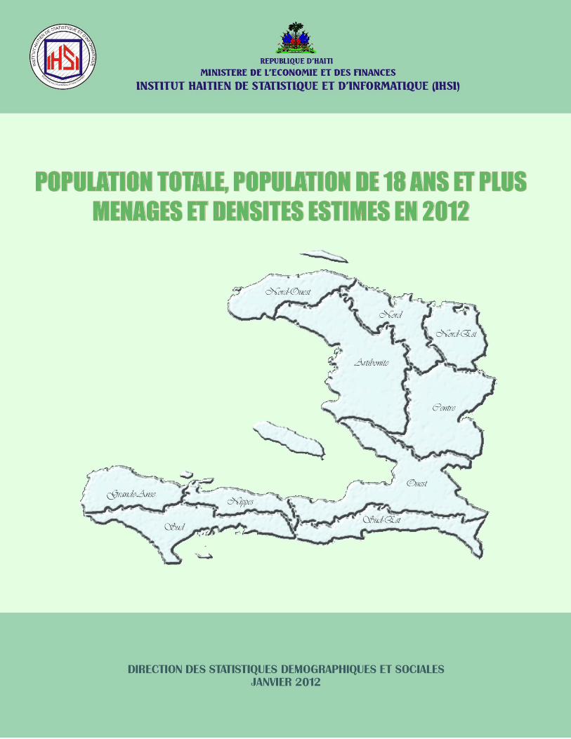
POPULATION TOTALE, POPULATION DE 18 ANS ET PLUSMENAGES ET DENSITES ESTIMES EN 2012

INSTITUT HAÏTIEN DE STATISTIQUE ET D’INFORMATIQUEJANVIER 2012
3POPULATION TOTALE, POPULATION DE 18 ANS ET PLUS ESTIMÉES EN 2012
AVANT-PROPOS
L ’Institut Haïtien de Statistique et d’Informatique (IHSI) prend plaisir
à livrer, comme d’habitude, au public en général et aux utilisateurs des
données statistiques en particulier, une estimation pour l’année 2012 des
populations totale et de 18 ans et plus du pays ainsi que du nombre de ménages et des
densités démographiques. Ces résultats, basés en partie sur les projections de population
élaborées par l’IHSI conjointement avec le Centre Latino–Américain de Démographie
(CELADE) de la Commission Economique des Nations Unies pour l’Amérique Latine et la
Caraïbe (CEPAL), sont présentés selon les différentes unités administratives du pays telles
que : département, arrondissement, commune et section communale.
L’Institut Haïtien de Statistique et d’Informatique (IHSI) présente, à cette occa-
sion, ses remerciements aux cadres techniques de la Direction des Statistiques
Démographiques et Sociales (DSDS) qui ont travaillé à la réalisation de cette publication.
En attendant les résultats de l’Enquête, actuellement en cours à l’IHSI, sur les Con-
ditions de Vie de la Population Après Séisme (ECVMAS) et du prochain Recensement de
Population dont les résultats serviront à la révision des projections, l’IHSI espère que les
données contenues dans cette publication répondront aux besoins des utilisateurs : Autorités
Gouvernementales, Agences d’Aide au Développement, Organismes Internationaux,
Chercheurs, Etudiants, etc.
Que chacun puisse en tirer le maximum de profit.
Danilia M. ALTIDORDirectrice Générale

INSTITUT HAÏTIEN DE STATISTIQUE ET D’INFORMATIQUEJANVIER 2012
5POPULATION TOTALE, POPULATION DE 18 ANS ET PLUS ESTIMÉES EN 2012
NOTE DE PRESENTATION
La présente publication rentre dans le cadre de la poursuite de la diffusion des données
démographiques. Grâce aux résultats du recensement réalisé en 2003, les projections existantes ont
été révisées et réalisées pour de nouvelles périodes. Par la même occasion, des estimations dérivées
ont été établies par la Direction des Statistiques Démographiques et Sociales (DSDS) de l’Institut
Haïtien de Statistique et d’Informatique (IHSI).
Réalisée conformément aux objectifs fixés dans le plan de travail de l’IHSI, cette publica-
tion ponctuelle devrait répondre convenablement aux nombreuses requêtes des utilisateurs de données.
Il est important de rappeler, que le présent travail n’a pas tenu compte des changements survenus
dans la dynamique de la population suite au cataclysme du 12 janvier 2010. Déjà, les activités
nécessaires à la réalisation du Ve recensement ont débuté, les résultats de cette opération et ceux de
l’ECVMAS devraient servir de toute évidence à la révision complète des projections et estimations
actuellement disponibles.
Cette publication comprend deux parties : la première présente pour l’année 2012 les résultats
des estimations de la population totale par sexe des différentes unités géographiques du pays
(Départements, Arrondissements, Communes, Sections Communales) ainsi que la population de dix-
huit (18) ans et plus; la seconde fournit pour la même année des données sur le nombre de ménages,
la superficie et la densité, selon les différentes unités géographiques au niveau des dix (10)
départements du pays.
L’IHSI formule le voeu que tout un chacun puisse tirer le maximum de profit dans l’utilisation
de cet important outil.
SOURCES DES DONNEES
Les sources de données utilisées sont les suivantes :
1- Résultats du recensement de 2003
Population totale par sexe selon le milieu de résidence;
IHSI/DSDSDIRECTION DES STATISTIQUES DÉMOGRAPHIQUES ET SOCIALES
6
Population totale des différentes unités géographiques du pays selon le milieu de
résidence (départements, communes);
Population par groupe d’âges et sexe selon le milieu de résidence;
Effectif des ménages des différentes unités géographiques du pays selon le milieu de
résidence (départements, communes);
Superficie des différentes unités géographiques du pays selon le milieu de résidence.
2- Projections de population par âge et sexe élaborées à l’échelle nationale par l’Institut Haïtien
de Statistique et d’Informatique (IHSI) avec le Centre Latino-Américain de Démographie
(CELADE) de 1950 à 2050;
3- Projections de population par groupe d’âges et sexe selon le milieu de résidence calculées à
l’échelle départementale, par l’IHSI et le CELADE pour la période allant de 2000 à 2015;
4- Estimations de la population totale, population de 18 ans et plus, ménages et densités estimés
pour les différentes unités géographiques du pays en 2009;
5- Estimations de la population totale, par groupe d’âges et sexe suivant le département et la
commune et le milieu de résidence en 2011.
METHODOLOGIQUE
La population des différentes unités géographiques du pays selon le milieu de résidence pour
l’année considérée a été estimée à partir des résultats annuels des projections globales réalisées
pour la période comprise entre 2000 et 2015. Ensuite, la structure des résultats des estimations de
2011 découlant de celle de 2003 a servi à l’estimation finale de la population des sections communales.
Considérant l’hypothèse d’une évolution lente de la structure démographique par sexe, les
résultats des estimations de 2011 ont été utilisés dans l’estimation de la répartition par sexe de la
population des différents départements et communes du pays pour l’année 2012.
INSTITUT HAÏTIEN DE STATISTIQUE ET D’INFORMATIQUEJANVIER 2012
7POPULATION TOTALE, POPULATION DE 18 ANS ET PLUS ESTIMÉES EN 2012
Pour la population âgée de dix-huit (18) ans et plus, la structure des résultats des estimations
de 2011 a été conservée. Ainsi, les résultats sont présentés pour chaque département, commune et
sections communales (Ville, Quartier, Sections Rurales).
L’estimation du nombre de ménages a été réalisée en deux étapes. La première démarche a
consisté à calculer le nombre de personnes par ménage pour les différentes unités géographiques
selon le milieu de résidence à partir des résultats des estimations de 2009. Une fois la taille des
ménages obtenue (nombre de personnes par ménage) la population des différentes unités géographiques
pour l’année considérée en l’occurrence l’année 2012 a été divisée par la taille correspondante
pour estimer le nombre de ménages.
Enfin, la densité de population est calculée à partir des informations connues. Elle est obtenue
pour chaque unité géographique en divisant l’effectif de la population de l’unité géographique
considérée en 2012 par sa superficie en km2.

INSTITUT HAÏTIEN DE STATISTIQUE ET D’INFORMATIQUEJANVIER 2012
9POPULATION TOTALE, POPULATION DE 18 ANS ET PLUS ESTIMÉES EN 2012
POPULATION DES DIFFÉRENTES UNITÉS GÉOGRAPHIQUES(DÉPARTEMENT, ARRONDISSEMENT, COMMUNE, SECTION COMMUNALE)

INSTITUT HAÏTIEN DE STATISTIQUE ET D’INFORMATIQUEJANVIER 2012
1 1POPULATION TOTALE, POPULATION DE 18 ANS ET PLUS ESTIMÉES EN 2012
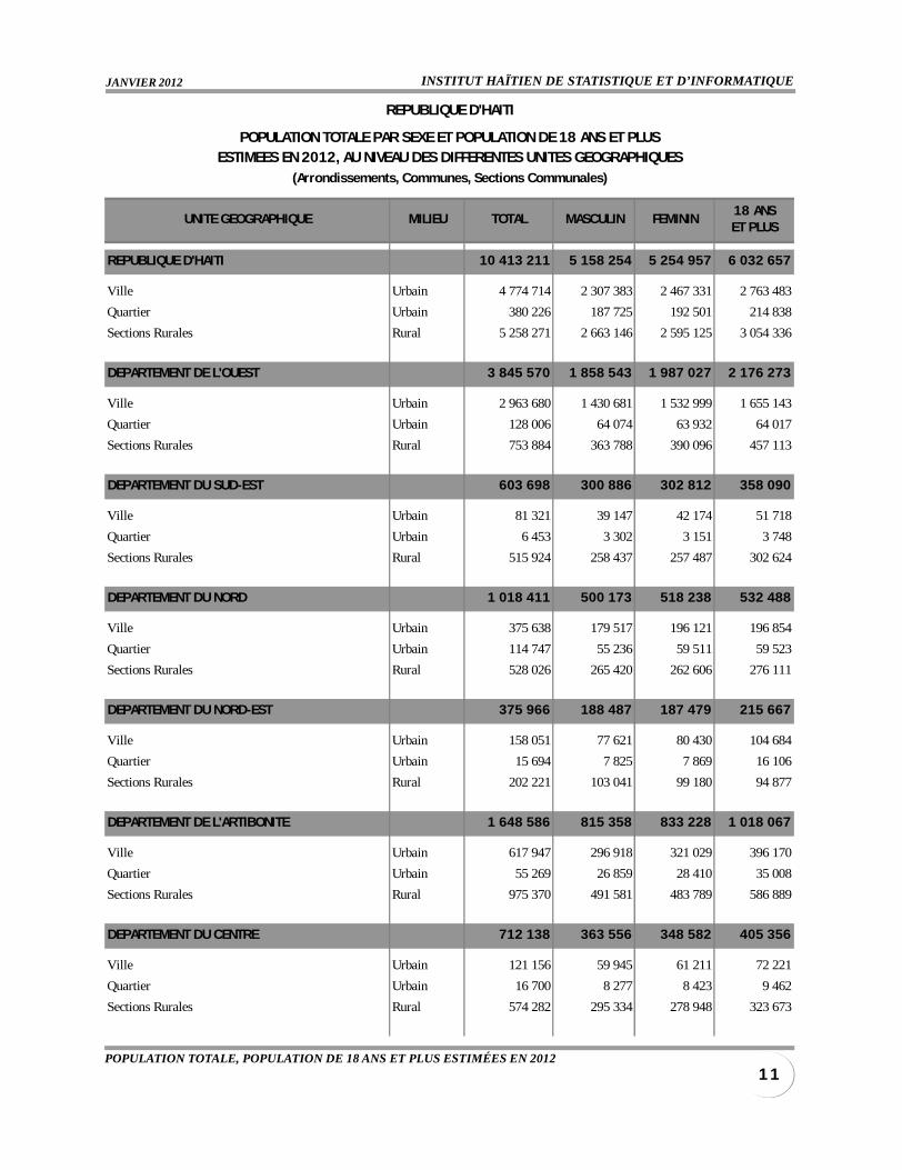
UNITE GEOGRAPHIQUE MILIEU TOTAL MASCULIN FEMININ18 ANSET PLUS
REPUBLIQUE D'HAITI 10 413 211 5 158 254 5 254 957 6 032 657
Ville Urbain 4 774 714 2 307 383 2 467 331 2 763 483
Quartier Urbain 380 226 187 725 192 501 214 838
Sections Rurales Rural 5 258 271 2 663 146 2 595 125 3 054 336
DEPARTEMENT DE L'OUEST 3 845 570 1 858 543 1 987 027 2 176 273
Ville Urbain 2 963 680 1 430 681 1 532 999 1 655 143
Quartier Urbain 128 006 64 074 63 932 64 017
Sections Rurales Rural 753 884 363 788 390 096 457 113
DEPARTEMENT DU SUD-EST 603 698 300 886 302 812 358 090
Ville Urbain 81 321 39 147 42 174 51 718
Quartier Urbain 6 453 3 302 3 151 3 748
Sections Rurales Rural 515 924 258 437 257 487 302 624
DEPARTEMENT DU NORD 1 018 411 500 173 518 238 532 488
Ville Urbain 375 638 179 517 196 121 196 854
Quartier Urbain 114 747 55 236 59 511 59 523
Sections Rurales Rural 528 026 265 420 262 606 276 111
DEPARTEMENT DU NORD-EST 375 966 188 487 187 479 215 667
Ville Urbain 158 051 77 621 80 430 104 684
Quartier Urbain 15 694 7 825 7 869 16 106
Sections Rurales Rural 202 221 103 041 99 180 94 877
DEPARTEMENT DE L'ARTIBONITE 1 648 586 815 358 833 228 1 018 067
Ville Urbain 617 947 296 918 321 029 396 170
Quartier Urbain 55 269 26 859 28 410 35 008
Sections Rurales Rural 975 370 491 581 483 789 586 889
DEPARTEMENT DU CENTRE 712 138 363 556 348 582 405 356
Ville Urbain 121 156 59 945 61 211 72 221
Quartier Urbain 16 700 8 277 8 423 9 462
Sections Rurales Rural 574 282 295 334 278 948 323 673
REPUBLIQUE D'HAITI
POPULATION TOTALE PAR SEXE ET POPULATION DE 18 ANS ET PLUSESTIMEES EN 2012, AU NIVEAU DES DIFFERENTES UNITES GEOGRAPHIQUES
(Arrondissements, Communes, Sections Communales)
IHSI/DSDSDIRECTION DES STATISTIQUES DÉMOGRAPHIQUES ET SOCIALES
1 2
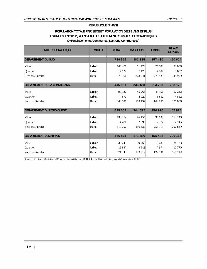
UNITE GEOGRAPHIQUE MILIEU TOTAL MASCULIN FEMININ18 ANSET PLUS
DEPARTEMENT DU SUD 739 565 382 135 357 430 450 604
Ville Urbain 146 477 71 474 75 003 93 088
Quartier Urbain 14 127 7 120 7 007 8 607
Sections Rurales Rural 578 961 303 541 275 420 348 909
DEPARTEMENT DE LA GRANDE-ANSE 446 901 233 138 213 763 268 172
Ville Urbain 90 922 45 966 44 956 57 232
Quartier Urbain 7 872 4 020 3 852 4 852
Sections Rurales Rural 348 107 183 152 164 955 206 088
DEPARTEMENT DU NORD-OUEST 695 502 344 592 350 910 407 824
Ville Urbain 180 779 86 154 94 625 112 240
Quartier Urbain 4 471 2 099 2 372 2 745
Sections Rurales Rural 510 252 256 339 253 913 292 839
DEPARTEMENT DES NIPPES 326 874 171 386 155 488 200 116
Ville Urbain 38 743 19 960 18 783 24 133
Quartier Urbain 16 887 8 913 7 974 10 770
Sections Rurales Rural 271 244 142 513 128 731 165 213
Source : Direction des Statistiques Démographiques et Sociales (DSDS), Institut Haïtien de Statistique et d'Informatique (IHSI)
REPUBLIQUE D'HAITI
POPULATION TOTALE PAR SEXE ET POPULATION DE 18 ANS ET PLUSESTIMEES EN 2012, AU NIVEAU DES DIFFERENTES UNITES GEOGRAPHIQUES
(Arrondissements, Communes, Sections Communales)
INSTITUT HAÏTIEN DE STATISTIQUE ET D’INFORMATIQUEJANVIER 2012
1 3POPULATION TOTALE, POPULATION DE 18 ANS ET PLUS ESTIMÉES EN 2012
UNITE GEOGRAPHIQUE MILIEU TOTAL MASCULIN FEMININ18 ANSET PLUS
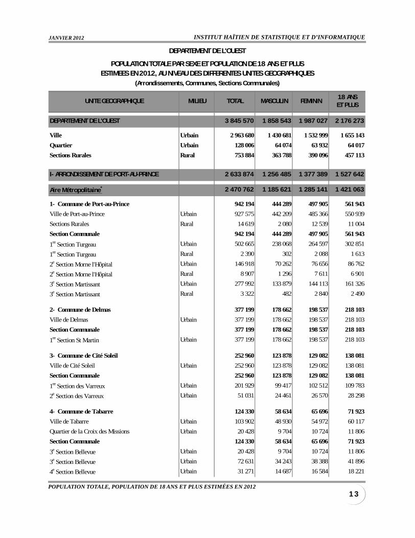
DEPARTEMENT DE L'OUEST 3 845 570 1 858 543 1 987 027 2 176 273
Ville Urbain 2 963 680 1 430 681 1 532 999 1 655 143
Quartier Urbain 128 006 64 074 63 932 64 017
Sections Rurales Rural 753 884 363 788 390 096 457 113
I- ARRONDISSEMENT DE PORT-AU-PRINCE 2 633 874 1 256 485 1 377 389 1 527 642
Aire Métropolitaine* 2 470 762 1 185 621 1 285 141 1 421 063
1- Commune de Port-au-Prince 942 194 444 289 497 905 561 943
Ville de Port-au-Prince Urbain 927 575 442 209 485 366 550 939
Sections Rurales Rural 14 619 2 080 12 539 11 004
Section Communale 942 194 444 289 497 905 561 943
1re Section Turgeau Urbain 502 665 238 068 264 597 302 851
1re Section Turgeau Rural 2 390 302 2 088 1 613
2e Section Morne l'Hôpital Urbain 146 918 70 262 76 656 86 762
2e Section Morne l'Hôpital Rural 8 907 1 296 7 611 6 901
3e Section Martissant Urbain 277 992 133 879 144 113 161 326
3e Section Martissant Rural 3 322 482 2 840 2 490
2- Commune de Delmas 377 199 178 662 198 537 218 103
Ville de Delmas Urbain 377 199 178 662 198 537 218 103
Section Communale 377 199 178 662 198 537 218 103
1re Section St Martin Urbain 377 199 178 662 198 537 218 103
3- Commune de Cité Soleil 252 960 123 878 129 082 138 081
Ville de Cité Soleil Urbain 252 960 123 878 129 082 138 081
Section Communale 252 960 123 878 129 082 138 081
1re Section des Varreux Urbain 201 929 99 417 102 512 109 783
2e Section des Varreux Urbain 51 031 24 461 26 570 28 298
4- Commune de Tabarre 124 330 58 634 65 696 71 923
Ville de Tabarre Urbain 103 902 48 930 54 972 60 117
Quartier de la Croix des Missions Urbain 20 428 9 704 10 724 11 806
Section Communale 124 330 58 634 65 696 71 923
3e Section Bellevue Urbain 20 428 9 704 10 724 11 806
3e Section Bellevue Urbain 72 631 34 243 38 388 41 896
4e Section Bellevue Urbain 31 271 14 687 16 584 18 221
DEPARTEMENT DE L'OUEST
POPULATION TOTALE PAR SEXE ET POPULATION DE 18 ANS ET PLUSESTIMEES EN 2012, AU NIVEAU DES DIFFERENTES UNITES GEOGRAPHIQUES
(Arrondissements, Communes, Sections Communales)
IHSI/DSDSDIRECTION DES STATISTIQUES DÉMOGRAPHIQUES ET SOCIALES
1 4
UNITE GEOGRAPHIQUE MILIEU TOTAL MASCULIN FEMININ18 ANSET PLUS
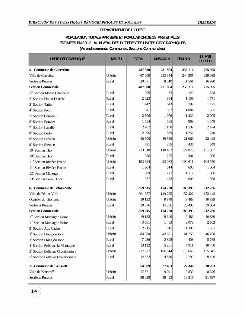
5- Commune de Carrefour 487 980 231 864 256 116 275 955
Ville de Carrefour Urbain 467 909 223 354 244 555 259 035
Sections Rurales Rural 20 071 8 510 11 561 16 920
Section Communale 487 980 231 864 256 116 275 955
1re Section Morne Chandelle Rural 205 83 122 198
2e Section Platon Dufréné Rural 2 023 864 1 159 1 771
3e Section Taïfer Rural 1 442 643 799 1 125
4e Section Procy Rural 1 941 857 1 084 1 635
5e Section Coupeau Rural 2 506 1 076 1 430 2 005
6e Section Bouvier Rural 1 654 685 969 1 549
7e Section Lavalle Rural 2 787 1 190 1 597 2 424
8e Section Berly Rural 2 096 839 1 257 1 740
9e Section Bizoton Urbain 40 905 19 839 21 066 22 498
9e Section Bizoton Rural 731 295 436 549
10e Section Thor Urbain 233 310 110 432 122 878 131 967
10e Section Thor Rural 536 235 301 396
11e Section Rivière Froide Urbain 193 694 93 083 100 611 104 570
11e Section Rivière Froide Rural 1 204 514 690 1 064
12e Section Malanga Rural 1 889 777 1 112 1 506
13e Section Corail Thor Rural 1 057 452 605 958
6- Commune de Pétion-Ville 359 615 174 220 185 395 212 786
Ville de Pétion-Ville Urbain 301 657 149 235 152 422 172 143
Quartier de Thomassin Urbain 19 132 9 649 9 483 10 839
Sections Rurales Rural 38 826 15 336 23 490 29 804
Section Communale 359 615 174 220 185 395 212 786
1re Section Montagne Noire Urbain 19 132 9 649 9 483 10 839
1re Section Montagne Noire Rural 3 561 1 482 2 079 2 502
2e Section Aux Cadets Rural 2 215 915 1 300 1 631
3e Section Etang du Jonc Urbain 84 380 42 621 41 759 46 798
3e Section Etang du Jonc Rural 7 236 2 828 4 408 5 765
4e Section Bellevue la Montagne Rural 13 192 5 281 7 911 10 480
5e Section Bellevue Chardonnière Urbain 217 277 106 614 110 663 125 345
5e Section Bellevue Chardonnière Rural 12 622 4 830 7 792 9 426
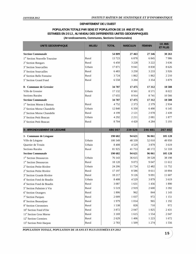
7- Commune de Kenscoff 54 809 27 463 27 346 30 263
Ville de Kenscoff Urbain 17 871 9 041 8 830 8 626
Sections Rurales Rural 36 938 18 422 18 516 21 637
DEPARTEMENT DE L'OUEST
POPULATION TOTALE PAR SEXE ET POPULATION DE 18 ANS ET PLUSESTIMEES EN 2012, AU NIVEAU DES DIFFERENTES UNITES GEOGRAPHIQUES
(Arrondissements, Communes, Sections Communales)
INSTITUT HAÏTIEN DE STATISTIQUE ET D’INFORMATIQUEJANVIER 2012
1 5POPULATION TOTALE, POPULATION DE 18 ANS ET PLUS ESTIMÉES EN 2012
UNITE GEOGRAPHIQUE MILIEU TOTAL MASCULIN FEMININ18 ANSET PLUS
Section Communale 54 809 27 463 27 346 30 263
1re Section Nouvelle Touraine Rural 13 723 6 878 6 845 7 986
2e Section Bongars Rural 6 450 3 228 3 222 3 636
3e Section Sourcailles Urbain 17 871 9 041 8 830 8 626
3e Section Sourcailles Rural 6 483 3 250 3 233 3 926
4e Section Belle Fontaine Rural 3 724 1 862 1 862 2 210
5e Section Grand Fond Rural 6 558 3 204 3 354 3 879
8- Commune de Gressier 34 787 17 475 17 312 18 588
Ville de Gressier Urbain 17 132 8 561 8 571 8 022
Sections Rurales Rural 17 655 8 914 8 741 10 566
Section Communale 34 787 17 475 17 312 18 588
1re Section Morne à Bateau Rural 4 752 2 373 2 379 2 934
2e Section Morne Chandelle Urbain 12 840 6 350 6 490 6 145
2e Section Morne Chandelle Rural 4 199 2 121 2 078 2 439
3e Section Petit Boucan Urbain 4 292 2 211 2 081 1 877
3e Section Petit Boucan Rural 8 704 4 420 4 284 5 193
II- ARRONDISSEMENT DE LEOGANE 486 007 239 526 246 481 267 402
1- Commune de Léogane 190 682 94 621 96 061 105 128
Ville de Léogane Urbain 100 349 48 339 52 010 49 950
Quartier de Trouin Urbain 8 408 4 529 3 879 3 619
Sections Rurales Rural 81 925 41 753 40 172 51 559
Section Communale 190 682 94 621 96 061 105 128
1re Section Dessources Urbain 76 143 36 615 39 528 38 198
1re Section Dessources Rural 18 120 9 073 9 047 11 612
2e Section Petite Rivière Urbain 24 206 11 724 12 482 11 752
2e Section Petite Rivière Rural 17 197 8 586 8 611 10 894
3e Section Grande Rivière Rural 18 217 9 126 9 091 11 607
4e Section Fond de Boudin Urbain 8 408 4 529 3 879 3 619
4e Section Fond de Boudin Rural 3 087 1 631 1 456 1 890
5e Section Palmiste à Vin Rural 5 519 2 919 2 600 3 392
6e Section Orangers Rural 1 806 962 844 1 143
7e Section Parques Rural 2 009 1 037 972 1 151
8e Section Beauséjour Rural 1 979 1 014 965 1 192
9e Section Citronniers Rural 1 538 828 710 972
10e Section Fond d'Oie Rural 3 872 2 047 1 825 2 431
11e Section Gros Morne Rural 3 169 1 615 1 554 2 047
12e Section Cormiers Rural 2 629 1 406 1 223 1 672
13e Section Petit Harpon Rural 2 783 1 509 1 274 1 556
DEPARTEMENT DE L'OUEST
POPULATION TOTALE PAR SEXE ET POPULATION DE 18 ANS ET PLUSESTIMEES EN 2012, AU NIVEAU DES DIFFERENTES UNITES GEOGRAPHIQUES
(Arrondissements, Communes, Sections Communales)
IHSI/DSDSDIRECTION DES STATISTIQUES DÉMOGRAPHIQUES ET SOCIALES
1 6
UNITE GEOGRAPHIQUE MILIEU TOTAL MASCULIN FEMININ18 ANSET PLUS
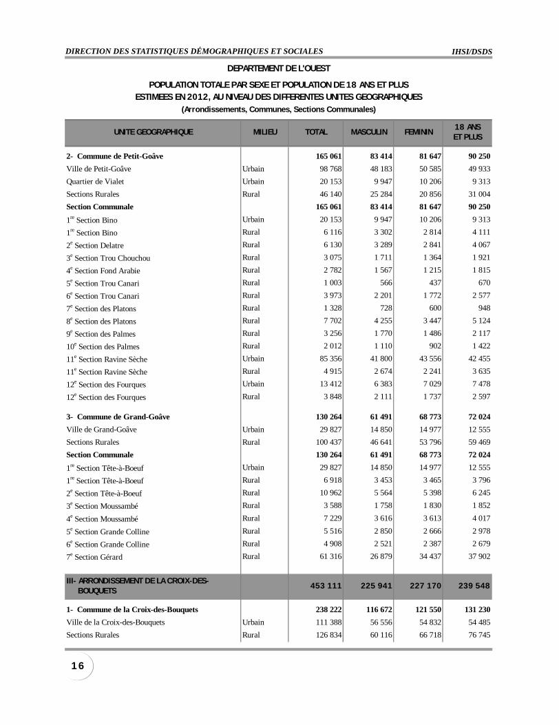
2- Commune de Petit-Goâve 165 061 83 414 81 647 90 250
Ville de Petit-Goâve Urbain 98 768 48 183 50 585 49 933
Quartier de Vialet Urbain 20 153 9 947 10 206 9 313
Sections Rurales Rural 46 140 25 284 20 856 31 004
Section Communale 165 061 83 414 81 647 90 250
1re Section Bino Urbain 20 153 9 947 10 206 9 313
1re Section Bino Rural 6 116 3 302 2 814 4 111
2e Section Delatre Rural 6 130 3 289 2 841 4 067
3e Section Trou Chouchou Rural 3 075 1 711 1 364 1 921
4e Section Fond Arabie Rural 2 782 1 567 1 215 1 815
5e Section Trou Canari Rural 1 003 566 437 670
6e Section Trou Canari Rural 3 973 2 201 1 772 2 577
7e Section des Platons Rural 1 328 728 600 948
8e Section des Platons Rural 7 702 4 255 3 447 5 124
9e Section des Palmes Rural 3 256 1 770 1 486 2 117
10e Section des Palmes Rural 2 012 1 110 902 1 422
11e Section Ravine Sèche Urbain 85 356 41 800 43 556 42 455
11e Section Ravine Sèche Rural 4 915 2 674 2 241 3 635
12e Section des Fourques Urbain 13 412 6 383 7 029 7 478
12e Section des Fourques Rural 3 848 2 111 1 737 2 597
3- Commune de Grand-Goâve 130 264 61 491 68 773 72 024
Ville de Grand-Goâve Urbain 29 827 14 850 14 977 12 555
Sections Rurales Rural 100 437 46 641 53 796 59 469
Section Communale 130 264 61 491 68 773 72 024
1re Section Tête-à-Boeuf Urbain 29 827 14 850 14 977 12 555
1re Section Tête-à-Boeuf Rural 6 918 3 453 3 465 3 796
2e Section Tête-à-Boeuf Rural 10 962 5 564 5 398 6 245
3e Section Moussambé Rural 3 588 1 758 1 830 1 852
4e Section Moussambé Rural 7 229 3 616 3 613 4 017
5e Section Grande Colline Rural 5 516 2 850 2 666 2 978
6e Section Grande Colline Rural 4 908 2 521 2 387 2 679
7e Section Gérard Rural 61 316 26 879 34 437 37 902
III- ARRONDISSEMENT DE LA CROIX-DES- BOUQUETS
453 111 225 941 227 170 239 548
1- Commune de la Croix-des-Bouquets 238 222 116 672 121 550 131 230
Ville de la Croix-des-Bouquets Urbain 111 388 56 556 54 832 54 485
Sections Rurales Rural 126 834 60 116 66 718 76 745
DEPARTEMENT DE L'OUEST
POPULATION TOTALE PAR SEXE ET POPULATION DE 18 ANS ET PLUSESTIMEES EN 2012, AU NIVEAU DES DIFFERENTES UNITES GEOGRAPHIQUES
(Arrondissements, Communes, Sections Communales)
INSTITUT HAÏTIEN DE STATISTIQUE ET D’INFORMATIQUEJANVIER 2012
1 7POPULATION TOTALE, POPULATION DE 18 ANS ET PLUS ESTIMÉES EN 2012
UNITE GEOGRAPHIQUE MILIEU TOTAL MASCULIN FEMININ18 ANSET PLUS
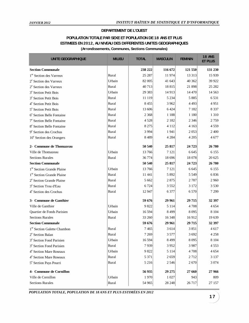
Section Communale 238 222 116 672 121 550 131 230
1re Section des Varreux Rural 25 287 11 974 13 313 15 939
2e Section des Varreux Urbain 82 005 41 643 40 362 39 922
2e Section des Varreux Rural 40 713 18 815 21 898 25 282
3e Section Petit Bois Urbain 29 383 14 913 14 470 14 563
3e Section Petit Bois Rural 11 119 5 234 5 885 6 531
4e Section Petit Bois Rural 8 455 3 962 4 493 4 951
5e Section Petit Bois Rural 13 606 6 424 7 182 8 337
6e Section Belle Fontaine Rural 2 368 1 188 1 180 1 310
7e Section Belle Fontaine Rural 4 528 2 182 2 346 2 759
8e Section Belle Fontaine Rural 8 275 4 112 4 163 4 559
9e Section des Crochus Rural 3 994 1 941 2 053 2 400
10e Section des Orangers Rural 8 489 4 284 4 205 4 677
2- Commune de Thomazeau 50 540 25 817 24 723 26 780
Ville de Thomazeau Urbain 13 766 7 121 6 645 6 155
Sections Rurales Rural 36 774 18 696 18 078 20 625
Section Communale 50 540 25 817 24 723 26 780
1re Section Grande Plaine Urbain 13 766 7 121 6 645 6 155
1re Section Grande Plaine Rural 11 441 5 892 5 549 6 836
2e Section Grande Plaine Rural 5 662 2 875 2 787 2 960
3e Section Trou d'Eau Rural 6 724 3 552 3 172 3 530
4e Section des Crochus Rural 12 947 6 377 6 570 7 299
3- Commune de Ganthier 59 676 29 961 29 715 32 397
Ville de Ganthier Urbain 9 822 5 114 4 708 4 654
Quartier de Fonds Parisien Urbain 16 594 8 499 8 095 8 104
Sections Rurales Rural 33 260 16 348 16 912 19 639
Section Communale 59 676 29 961 29 715 32 397
1re Section Galette Chambon Rural 7 465 3 614 3 851 4 617
2e Section Balan Rural 7 269 3 577 3 692 4 258
3e Section Fond Parisien Urbain 16 594 8 499 8 095 8 104
3e Section Fond Parisien Rural 7 939 3 952 3 987 4 553
4e Section Mare Roseaux Urbain 9 822 5 114 4 708 4 654
4e Section Mare Roseaux Rural 5 371 2 659 2 712 3 137
5e Section Pays Pourri Rural 5 216 2 546 2 670 3 074
4- Commune de Cornillon 56 935 29 275 27 660 27 966
Ville de Cornillon Urbain 1 970 1 027 943 809
Sections Rurales Rural 54 965 28 248 26 717 27 157
DEPARTEMENT DE L'OUEST
POPULATION TOTALE PAR SEXE ET POPULATION DE 18 ANS ET PLUSESTIMEES EN 2012, AU NIVEAU DES DIFFERENTES UNITES GEOGRAPHIQUES
(Arrondissements, Communes, Sections Communales)
IHSI/DSDSDIRECTION DES STATISTIQUES DÉMOGRAPHIQUES ET SOCIALES
1 8
UNITE GEOGRAPHIQUE MILIEU TOTAL MASCULIN FEMININ18 ANSET PLUS
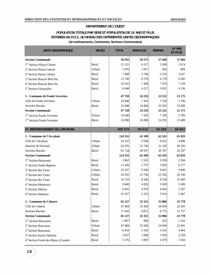
Section Communale 56 935 29 275 27 660 27 966
1re Section Plaine Céleste Rural 12 155 6 217 5 938 5 674
2e Section Plaine Céleste Urbain 1 970 1 027 943 809
2e Section Plaine Céleste Rural 7 488 3 786 3 702 3 637
3e Section Boucan Bois Pin Rural 12 749 6 579 6 170 6 582
4e Section Boucan Bois Pin Rural 14 525 7 449 7 076 7 128
5e Section Génipailler Rural 8 048 4 217 3 831 4 136
5- Commune de Fonds-Verrettes 47 738 24 216 23 522 21 175
Ville de Fonds-Verrettes Urbain 14 640 7 410 7 230 5 766
Sections Rurales Rural 33 098 16 806 16 292 15 409
Section Communale 47 738 24 216 23 522 21 175
1re Section Fonds-Verrettes Urbain 14 640 7 410 7 230 5 766
1re Section Fonds-Verrettes Rural 33 098 16 806 16 292 15 409
IV- ARRONDISSEMENT DE L'ARCAHAIE 189 479 94 510 94 969 99 607
1- Commune de l'Arcahaie 124 352 62 189 62 163 65 829
Ville de l'Arcahaie Urbain 19 337 9 506 9 831 9 896
Quartier de Saintard Urbain 43 291 21 746 21 545 20 336
Sections Rurales Rural 61 724 30 937 30 787 35 597
Section Communale 124 352 62 189 62 163 65 829
1re Section Boucassin Rural 3 962 1 923 2 039 2 504
2e Section Fonds Baptiste Rural 11 430 5 737 5 693 6 177
3e Section des Vases Urbain 19 337 9 506 9 831 9 896
3e Section des Vases Urbain 43 291 21 746 21 545 20 336
3e Section des Vases Rural 16 716 8 166 8 550 10 443
4e Section Montrouis Rural 9 848 4 820 5 028 5 499
5e Section Délices Rural 9 441 4 978 4 463 5 507
6e Section Matheux Rural 10 327 5 313 5 014 5 467
2- Commune de Cabaret 65 127 32 321 32 806 33 778
Ville de Cabaret Urbain 47 484 23 450 24 034 22 041
Sections Rurales Rural 17 643 8 871 8 772 11 737
Section Communale 65 127 32 321 32 806 33 778
1re Section Boucassin Rural 1 807 884 923 1 241
2e Section Boucassin Urbain 47 484 23 450 24 034 22 041
2e Section Boucassin Rural 6 433 3 192 3 241 4 464
3e Section Source Matelas Rural 3 827 1 898 1 929 2 528
4e Section Fonds des Blancs (Casale) Rural 5 576 2 897 2 679 3 504
DEPARTEMENT DE L'OUEST
POPULATION TOTALE PAR SEXE ET POPULATION DE 18 ANS ET PLUSESTIMEES EN 2012, AU NIVEAU DES DIFFERENTES UNITES GEOGRAPHIQUES
(Arrondissements, Communes, Sections Communales)
INSTITUT HAÏTIEN DE STATISTIQUE ET D’INFORMATIQUEJANVIER 2012
1 9POPULATION TOTALE, POPULATION DE 18 ANS ET PLUS ESTIMÉES EN 2012
UNITE GEOGRAPHIQUE MILIEU TOTAL MASCULIN FEMININ18 ANSET PLUS
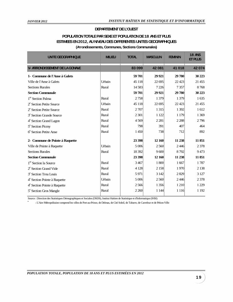
V- ARRONDISSEMENT DE LA GONAVE 83 099 42 081 41 018 42 074
1- Commune de l'Anse à Galets 59 701 29 921 29 780 30 223
Ville de l'Anse à Galets Urbain 45 118 22 695 22 423 21 455
Sections Rurales Rural 14 583 7 226 7 357 8 768
Section Communale 59 701 29 921 29 780 30 223
1re Section Palma Rural 2 758 1 379 1 379 1 635
2e Section Petite Source Urbain 45 118 22 695 22 423 21 455
2e Section Petite Source Rural 2 707 1 315 1 392 1 612
3e Section Grande Source Rural 2 301 1 122 1 179 1 369
4e Section Grand Lagon Rural 4 569 2 281 2 288 2 796
5e Section Picmy Rural 798 391 407 464
6e Section Petite Anse Rural 1 450 738 712 892
2- Commune de Pointe à Raquette 23 398 12 160 11 238 11 851
Ville de Pointe à Raquette Urbain 5 006 2 560 2 446 2 378
Sections Rurales Rural 18 392 9 600 8 792 9 473
Section Communale 23 398 12 160 11 238 11 851
1re Section la Source Rural 3 467 1 800 1 667 1 787
2e Section Grand Vide Rural 4 128 2 158 1 970 2 138
3e Section Trou Louis Rural 5 971 3 142 2 829 3 127
4e Section Pointe à Raquette Urbain 5 006 2 560 2 446 2 378
4e Section Pointe à Raquette Rural 2 566 1 356 1 210 1 229
5e Section Gros Mangle Rural 2 260 1 144 1 116 1 192
Source : Direction des Statistiques Démographiques et Sociales (DSDS), Institut Haïtien de Statistique et d'Informatique (IHSI)* : L'Aire Métropolitaine comprend les villes de Port-au-Prince, de Delmas, de Cité Soleil, de Tabarre, de Carrefour et de Pétion-Ville
DEPARTEMENT DE L'OUEST
POPULATION TOTALE PAR SEXE ET POPULATION DE 18 ANS ET PLUSESTIMEES EN 2012, AU NIVEAU DES DIFFERENTES UNITES GEOGRAPHIQUES
(Arrondissements, Communes, Sections Communales)
IHSI/DSDSDIRECTION DES STATISTIQUES DÉMOGRAPHIQUES ET SOCIALES
2 0
UNITE GEOGRAPHIQUE MILIEU TOTAL MASCULIN FEMININ18 ANSET PLUS
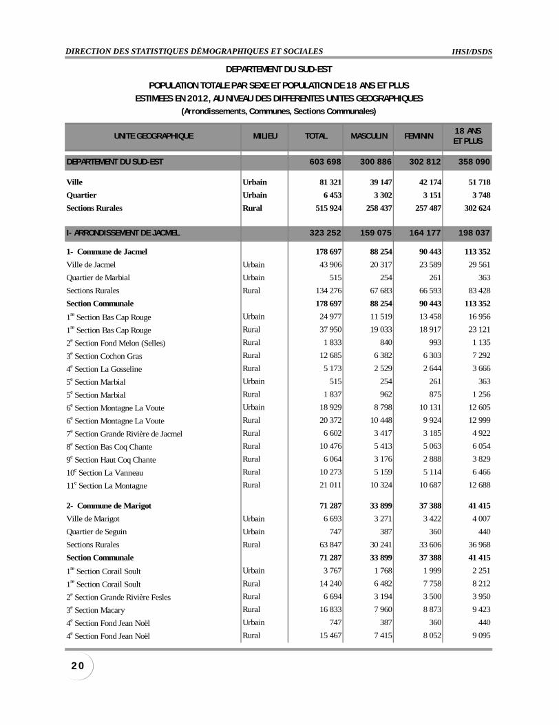
DEPARTEMENT DU SUD-EST 603 698 300 886 302 812 358 090
Ville Urbain 81 321 39 147 42 174 51 718
Quartier Urbain 6 453 3 302 3 151 3 748
Sections Rurales Rural 515 924 258 437 257 487 302 624
I- ARRONDISSEMENT DE JACMEL 323 252 159 075 164 177 198 037
1- Commune de Jacmel 178 697 88 254 90 443 113 352
Ville de Jacmel Urbain 43 906 20 317 23 589 29 561
Quartier de Marbial Urbain 515 254 261 363
Sections Rurales Rural 134 276 67 683 66 593 83 428
Section Communale 178 697 88 254 90 443 113 352
1re Section Bas Cap Rouge Urbain 24 977 11 519 13 458 16 956
1re Section Bas Cap Rouge Rural 37 950 19 033 18 917 23 121
2e Section Fond Melon (Selles) Rural 1 833 840 993 1 135
3e Section Cochon Gras Rural 12 685 6 382 6 303 7 292
4e Section La Gosseline Rural 5 173 2 529 2 644 3 666
5e Section Marbial Urbain 515 254 261 363
5e Section Marbial Rural 1 837 962 875 1 256
6e Section Montagne La Voute Urbain 18 929 8 798 10 131 12 605
6e Section Montagne La Voute Rural 20 372 10 448 9 924 12 999
7e Section Grande Rivière de Jacmel Rural 6 602 3 417 3 185 4 922
8e Section Bas Coq Chante Rural 10 476 5 413 5 063 6 054
9e Section Haut Coq Chante Rural 6 064 3 176 2 888 3 829
10e Section La Vanneau Rural 10 273 5 159 5 114 6 466
11e Section La Montagne Rural 21 011 10 324 10 687 12 688
2- Commune de Marigot 71 287 33 899 37 388 41 415
Ville de Marigot Urbain 6 693 3 271 3 422 4 007
Quartier de Seguin Urbain 747 387 360 440
Sections Rurales Rural 63 847 30 241 33 606 36 968
Section Communale 71 287 33 899 37 388 41 415
1re Section Corail Soult Urbain 3 767 1 768 1 999 2 251
1re Section Corail Soult Rural 14 240 6 482 7 758 8 212
2e Section Grande Rivière Fesles Rural 6 694 3 194 3 500 3 950
3e Section Macary Rural 16 833 7 960 8 873 9 423
4e Section Fond Jean Noël Urbain 747 387 360 440
4e Section Fond Jean Noël Rural 15 467 7 415 8 052 9 095
DEPARTEMENT DU SUD-EST
POPULATION TOTALE PAR SEXE ET POPULATION DE 18 ANS ET PLUS
ESTIMEES EN 2012, AU NIVEAU DES DIFFERENTES UNITES GEOGRAPHIQUES(Arrondissements, Communes, Sections Communales)
INSTITUT HAÏTIEN DE STATISTIQUE ET D’INFORMATIQUEJANVIER 2012
2 1POPULATION TOTALE, POPULATION DE 18 ANS ET PLUS ESTIMÉES EN 2012
UNITE GEOGRAPHIQUE MILIEU TOTAL MASCULIN FEMININ18 ANSET PLUS
5e Section Savane Dubois Urbain 2 926 1 503 1 423 1 756
5e Section Savane Dubois Rural 10 613 5 190 5 423 6 288
3- Commune de Cayes-Jacmel 38 505 18 700 19 805 22 619
Ville de Cayes-Jacmel Urbain 3 601 1 755 1 846 2 234
Sections Rurales Rural 34 904 16 945 17 959 20 385
Section Communale 38 505 18 700 19 805 22 619
1re Section Ravine Normande Urbain 1 726 871 855 1 091
1re Section Ravine Normande Rural 9 556 4 628 4 928 5 520
2e Section Gaillard Urbain 1 875 884 991 1 143
2e Section Gaillard Rural 13 153 6 390 6 763 7 877
3e Section Haut Cap Rouge Rural 5 785 2 794 2 991 3 253
2e Section Fond Melon Michineau Rural 6 410 3 133 3 277 3 735
4- Commune de La Vallée 34 763 18 222 16 541 20 651
Ville de La Vallée Urbain 1 150 591 559 689
Sections Rurales Rural 33 613 17 631 15 982 19 962
Section Communale 34 763 18 222 16 541 20 651
1re Section La Vallée de Jacmel ou Muzac Urbain 1 150 591 559 689
1re Section La Vallée de Jacmel ou Muzac Rural 14 251 7 568 6 683 8 413
2e Section La Vallée de Bainet ou Ternier Rural 9 548 5 030 4 518 5 634
3e Section Morne à Brûler Rural 9 814 5 033 4 781 5 915
II- ARRONDISSEMENT DE BAINET 129 588 66 885 62 703 76 908
1- Commune de Bainet 82 791 42 181 40 610 49 040
Ville de Bainet Urbain 3 664 1 807 1 857 2 337
Sections Rurales Rural 79 127 40 374 38 753 46 703
Section Communale 82 791 42 181 40 610 49 040
1re Section Brésilienne Rural 10 507 5 386 5 121 6 171
2e Section Trou Mahot Rural 9 691 4 951 4 740 5 507
3e Section La Vallée de Bainet Rural 10 042 5 229 4 813 5 884
4e Section Haut Grandou Rural 4 943 2 526 2 417 2 890
5e Section Bas de Grandou Urbain 3 664 1 807 1 857 2 337
5e Section Bas de Grandou Rural 11 118 5 677 5 441 6 738
6e Section Bas de Lacroix Rural 1 803 923 880 1 086
7e Section Bras Gauche Rural 4 616 2 333 2 283 2 873
8e Section Oranger Rural 8 235 4 110 4 125 5 034
9e Section Bas des Gris Gris Rural 18 172 9 239 8 933 10 520
2- Communes de Côtes de Fer 46 797 24 704 22 093 27 868
Ville de Côtes de Fer Urbain 2 227 1 161 1 066 1 359
Sections Rurales Rural 44 570 23 543 21 027 26 509
DEPARTEMENT DU SUD-EST
POPULATION TOTALE PAR SEXE ET POPULATION DE 18 ANS ET PLUS
ESTIMEES EN 2012, AU NIVEAU DES DIFFERENTES UNITES GEOGRAPHIQUES(Arrondissements, Communes, Sections Communales)
IHSI/DSDSDIRECTION DES STATISTIQUES DÉMOGRAPHIQUES ET SOCIALES
2 2
UNITE GEOGRAPHIQUE MILIEU TOTAL MASCULIN FEMININ18 ANSET PLUS
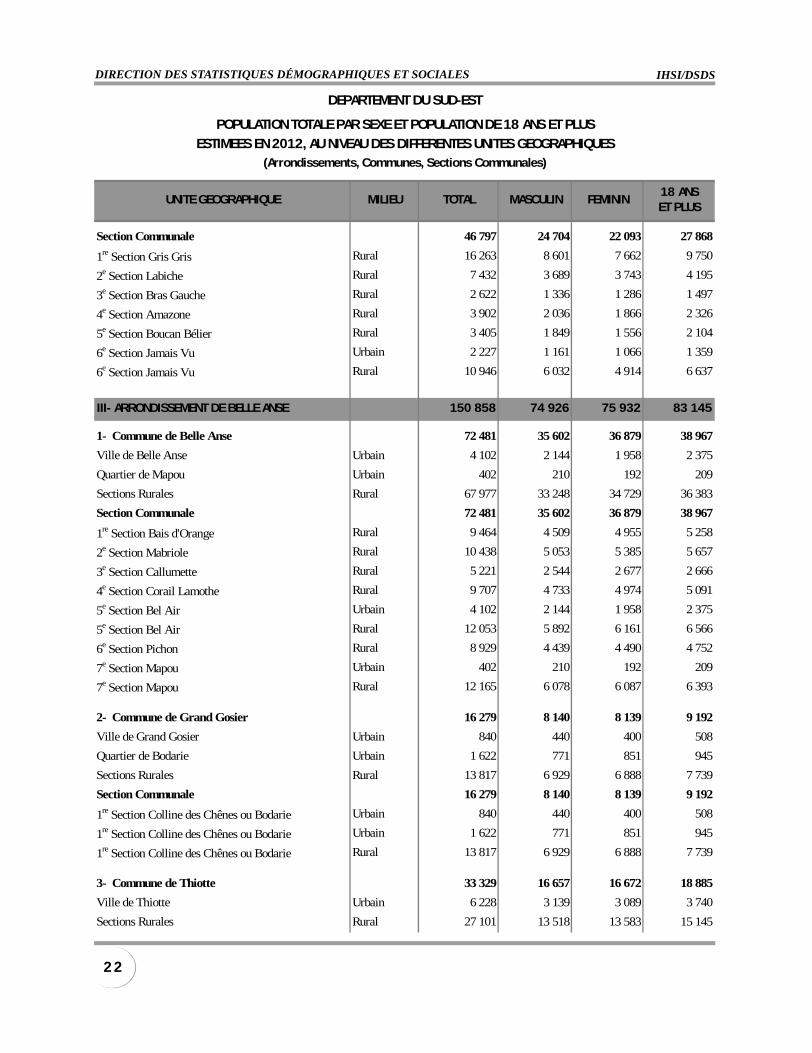
Section Communale 46 797 24 704 22 093 27 868
1re Section Gris Gris Rural 16 263 8 601 7 662 9 750
2e Section Labiche Rural 7 432 3 689 3 743 4 195
3e Section Bras Gauche Rural 2 622 1 336 1 286 1 497
4e Section Amazone Rural 3 902 2 036 1 866 2 326
5e Section Boucan Bélier Rural 3 405 1 849 1 556 2 104
6e Section Jamais Vu Urbain 2 227 1 161 1 066 1 359
6e Section Jamais Vu Rural 10 946 6 032 4 914 6 637
III- ARRONDISSEMENT DE BELLE ANSE 150 858 74 926 75 932 83 145
1- Commune de Belle Anse 72 481 35 602 36 879 38 967
Ville de Belle Anse Urbain 4 102 2 144 1 958 2 375
Quartier de Mapou Urbain 402 210 192 209
Sections Rurales Rural 67 977 33 248 34 729 36 383
Section Communale 72 481 35 602 36 879 38 967
1re Section Bais d'Orange Rural 9 464 4 509 4 955 5 258
2e Section Mabriole Rural 10 438 5 053 5 385 5 657
3e Section Callumette Rural 5 221 2 544 2 677 2 666
4e Section Corail Lamothe Rural 9 707 4 733 4 974 5 091
5e Section Bel Air Urbain 4 102 2 144 1 958 2 375
5e Section Bel Air Rural 12 053 5 892 6 161 6 566
6e Section Pichon Rural 8 929 4 439 4 490 4 752
7e Section Mapou Urbain 402 210 192 209
7e Section Mapou Rural 12 165 6 078 6 087 6 393
2- Commune de Grand Gosier 16 279 8 140 8 139 9 192
Ville de Grand Gosier Urbain 840 440 400 508
Quartier de Bodarie Urbain 1 622 771 851 945
Sections Rurales Rural 13 817 6 929 6 888 7 739
Section Communale 16 279 8 140 8 139 9 192
1re Section Colline des Chênes ou Bodarie Urbain 840 440 400 508
1re Section Colline des Chênes ou Bodarie Urbain 1 622 771 851 945
1re Section Colline des Chênes ou Bodarie Rural 13 817 6 929 6 888 7 739
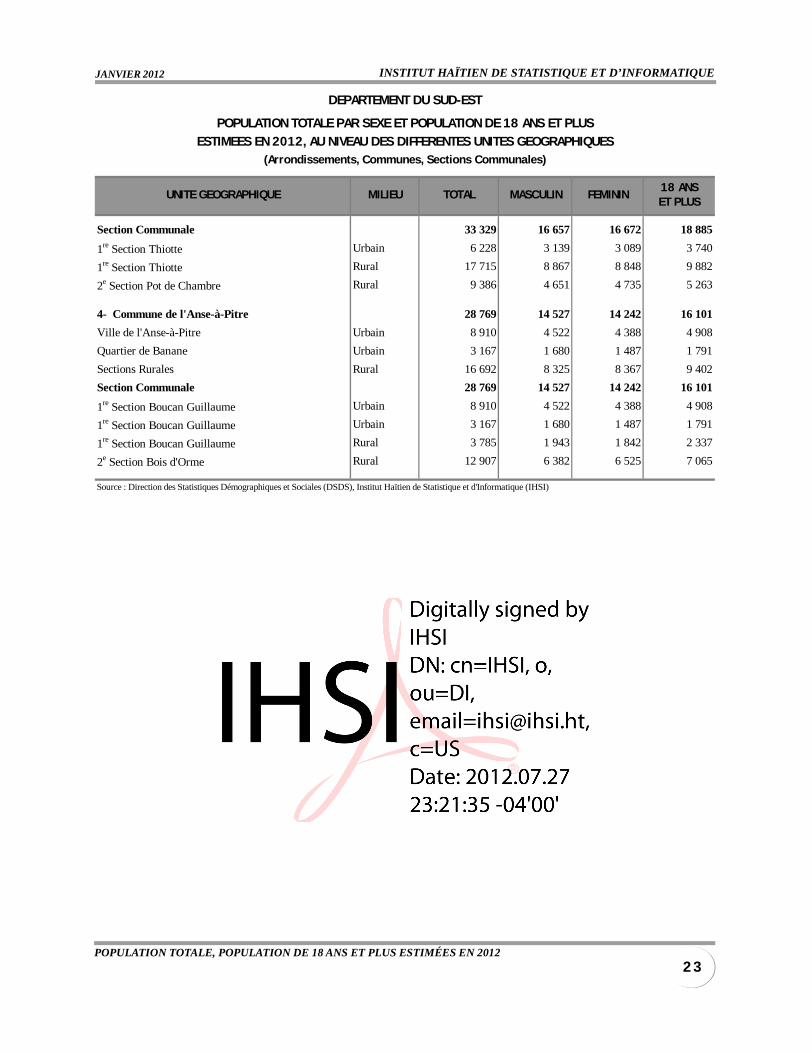
3- Commune de Thiotte 33 329 16 657 16 672 18 885
Ville de Thiotte Urbain 6 228 3 139 3 089 3 740
Sections Rurales Rural 27 101 13 518 13 583 15 145
DEPARTEMENT DU SUD-EST
POPULATION TOTALE PAR SEXE ET POPULATION DE 18 ANS ET PLUS
ESTIMEES EN 2012, AU NIVEAU DES DIFFERENTES UNITES GEOGRAPHIQUES(Arrondissements, Communes, Sections Communales)
INSTITUT HAÏTIEN DE STATISTIQUE ET D’INFORMATIQUEJANVIER 2012
2 3POPULATION TOTALE, POPULATION DE 18 ANS ET PLUS ESTIMÉES EN 2012
UNITE GEOGRAPHIQUE MILIEU TOTAL MASCULIN FEMININ18 ANSET PLUS
Section Communale 33 329 16 657 16 672 18 885
1re Section Thiotte Urbain 6 228 3 139 3 089 3 740
1re Section Thiotte Rural 17 715 8 867 8 848 9 882
2e Section Pot de Chambre Rural 9 386 4 651 4 735 5 263
4- Commune de l'Anse-à-Pitre 28 769 14 527 14 242 16 101
Ville de l'Anse-à-Pitre Urbain 8 910 4 522 4 388 4 908
Quartier de Banane Urbain 3 167 1 680 1 487 1 791
Sections Rurales Rural 16 692 8 325 8 367 9 402
Section Communale 28 769 14 527 14 242 16 101
1re Section Boucan Guillaume Urbain 8 910 4 522 4 388 4 908
1re Section Boucan Guillaume Urbain 3 167 1 680 1 487 1 791
1re Section Boucan Guillaume Rural 3 785 1 943 1 842 2 337
2e Section Bois d'Orme Rural 12 907 6 382 6 525 7 065
Source : Direction des Statistiques Démographiques et Sociales (DSDS), Institut Haïtien de Statistique et d'Informatique (IHSI)
DEPARTEMENT DU SUD-EST
POPULATION TOTALE PAR SEXE ET POPULATION DE 18 ANS ET PLUS
ESTIMEES EN 2012, AU NIVEAU DES DIFFERENTES UNITES GEOGRAPHIQUES(Arrondissements, Communes, Sections Communales)
IHSI/DSDSDIRECTION DES STATISTIQUES DÉMOGRAPHIQUES ET SOCIALES
2 4
UNITE GEOGRAPHIQUE MILIEU TOTAL MASCULIN FEMININ18 ANSET PLUS
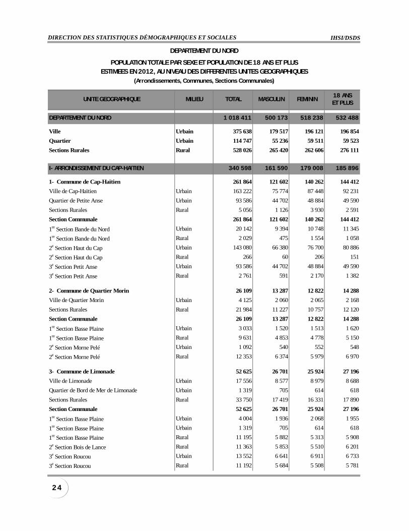
DEPARTEMENT DU NORD 1 018 411 500 173 518 238 532 488
Ville Urbain 375 638 179 517 196 121 196 854
Quartier Urbain 114 747 55 236 59 511 59 523
Sections Rurales Rural 528 026 265 420 262 606 276 111
I- ARRONDISSEMENT DU CAP-HAITIEN 340 598 161 590 179 008 185 896
1- Commune de Cap-Haïtien 261 864 121 602 140 262 144 412
Ville de Cap-Haïtien Urbain 163 222 75 774 87 448 92 231
Quartier de Petite Anse Urbain 93 586 44 702 48 884 49 590
Sections Rurales Rural 5 056 1 126 3 930 2 591
Section Communale 261 864 121 602 140 262 144 412
1re Section Bande du Nord Urbain 20 142 9 394 10 748 11 345
1re Section Bande du Nord Rural 2 029 475 1 554 1 058
2e Section Haut du Cap Urbain 143 080 66 380 76 700 80 886
2e Section Haut du Cap Rural 266 60 206 151
3e Section Petit Anse Urbain 93 586 44 702 48 884 49 590
3e Section Petit Anse Rural 2 761 591 2 170 1 382
2- Commune de Quartier Morin 26 109 13 287 12 822 14 288
Ville de Quartier Morin Urbain 4 125 2 060 2 065 2 168
Sections Rurales Rural 21 984 11 227 10 757 12 120
Section Communale 26 109 13 287 12 822 14 288
1re Section Basse Plaine Urbain 3 033 1 520 1 513 1 620
1re Section Basse Plaine Rural 9 631 4 853 4 778 5 150
2e Section Morne Pelé Urbain 1 092 540 552 548
2e Section Morne Pelé Rural 12 353 6 374 5 979 6 970
3- Commune de Limonade 52 625 26 701 25 924 27 196
Ville de Limonade Urbain 17 556 8 577 8 979 8 688
Quartier de Bord de Mer de Limonade Urbain 1 319 705 614 618
Sections Rurales Rural 33 750 17 419 16 331 17 890
Section Communale 52 625 26 701 25 924 27 196
1re Section Basse Plaine Urbain 4 004 1 936 2 068 1 955
1re Section Basse Plaine Urbain 1 319 705 614 618
1re Section Basse Plaine Rural 11 195 5 882 5 313 5 908
2e Section Bois de Lance Rural 11 363 5 853 5 510 6 201
3e Section Roucou Urbain 13 552 6 641 6 911 6 733
3e Section Roucou Rural 11 192 5 684 5 508 5 781
DEPARTEMENT DU NORD
POPULATION TOTALE PAR SEXE ET POPULATION DE 18 ANS ET PLUSESTIMEES EN 2012, AU NIVEAU DES DIFFERENTES UNITES GEOGRAPHIQUES
(Arrondissements, Communes, Sections Communales)

INSTITUT HAÏTIEN DE STATISTIQUE ET D’INFORMATIQUEJANVIER 2012
2 5POPULATION TOTALE, POPULATION DE 18 ANS ET PLUS ESTIMÉES EN 2012
UNITE GEOGRAPHIQUE MILIEU TOTAL MASCULIN FEMININ18 ANSET PLUS
II- ARRONDISSEMNT DE L'ACUL DU NORD 123 253 61 529 61 724 64 852
1- Commune de l'Acul du Nord 53 353 26 894 26 459 28 981
Ville de l'Acul du Nord Urbain 9 394 4 609 4 785 4 680
Quartier de Camp Louise Urbain 1 615 848 767 821
Quartier de La Soufrière Urbain 589 330 259 290
Sections Rurales Rural 41 755 21 107 20 648 23 190
Section Communale 53 353 26 894 26 459 28 981
1re Section Camp Louise Urbain 1 615 848 767 821
1re Section Camp Louise Rural 6 876 3 471 3 405 3 814
2e Section Bas de l'Acul (Basse Plaine) Urbain 9 394 4 609 4 785 4 680
2e Section Bas de l'Acul (Basse Plaine) Rural 11 294 5 737 5 557 6 050
3e Section Mornet Rural 10 793 5 274 5 519 6 102
4e Section Grande Ravine Rural 3 571 1 833 1 738 2 167
5e Section Coupe à David Rural 2 766 1 444 1 322 1 455
6e Section Soufrière Urbain 589 330 259 290
6e Section Soufrière Rural 6 455 3 348 3 107 3 602
2- Commune de Plaine du Nord 39 370 19 278 20 092 20 029
Ville de Plaine du Nord Urbain 9 648 4 701 4 947 4 792
Quartier de Robillard Urbain 3 173 1 495 1 678 1 447
Sections Rurales Rural 26 549 13 082 13 467 13 790
Section Communale 39 370 19 278 20 092 20 029
1re Section Morne Rouge Rural 14 526 7 182 7 344 7 789
2e Section Basse Plaine Urbain 9 648 4 701 4 947 4 792
2e Section Basse Plaine Rural 4 498 2 231 2 267 2 341
3e Section Grand Boucan Urbain 3 173 1 495 1 678 1 447
3e Section Grand Boucan Rural 6 181 2 989 3 192 2 965
4e Section Bassin Diamant Rural 1 344 680 664 695
3- Commune de Milot 30 530 15 357 15 173 15 842
Ville de Milot Urbain 7 460 3 637 3 823 3 767
Quartier de Carrefour des Pères Urbain 1 829 914 915 864
Sections Rurales Rural 21 241 10 806 10 435 11 211
Section Communale 30 530 15 357 15 173 15 842
1re Section Perches de Bonnet Rural 9 667 4 865 4 802 4 887
2e Section Bonnet à l'Evèque Urbain 7 460 3 637 3 823 3 767
2e Section Bonnet à l'Evèque Rural 4 817 2 397 2 420 2 562
3e Section Genipailler Urbain 1 829 914 915 864
3e Section Genipailler Rural 6 757 3 544 3 213 3 762
DEPARTEMENT DU NORD
POPULATION TOTALE PAR SEXE ET POPULATION DE 18 ANS ET PLUSESTIMEES EN 2012, AU NIVEAU DES DIFFERENTES UNITES GEOGRAPHIQUES
(Arrondissements, Communes, Sections Communales)
IHSI/DSDSDIRECTION DES STATISTIQUES DÉMOGRAPHIQUES ET SOCIALES
2 6
UNITE GEOGRAPHIQUE MILIEU TOTAL MASCULIN FEMININ18 ANSET PLUS
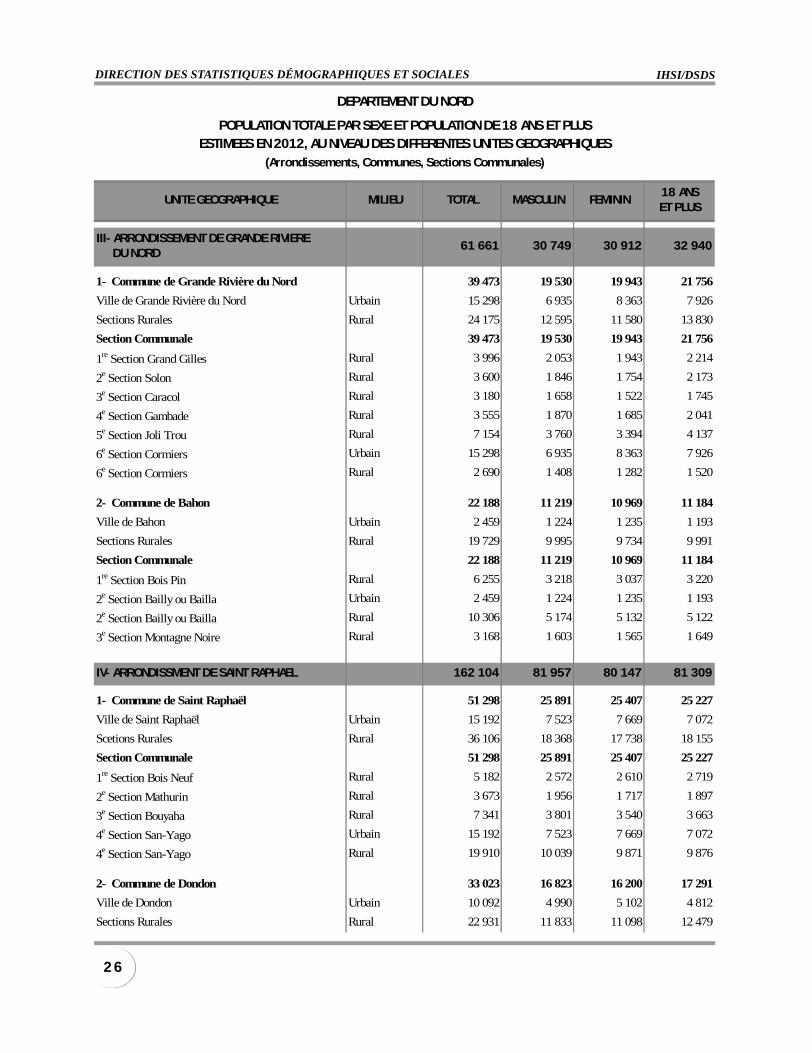
III- ARRONDISSEMENT DE GRANDE RIVIERE DU NORD
61 661 30 749 30 912 32 940
1- Commune de Grande Rivière du Nord 39 473 19 530 19 943 21 756
Ville de Grande Rivière du Nord Urbain 15 298 6 935 8 363 7 926
Sections Rurales Rural 24 175 12 595 11 580 13 830
Section Communale 39 473 19 530 19 943 21 756
1re Section Grand Gilles Rural 3 996 2 053 1 943 2 214
2e Section Solon Rural 3 600 1 846 1 754 2 173
3e Section Caracol Rural 3 180 1 658 1 522 1 745
4e Section Gambade Rural 3 555 1 870 1 685 2 041
5e Section Joli Trou Rural 7 154 3 760 3 394 4 137
6e Section Cormiers Urbain 15 298 6 935 8 363 7 926
6e Section Cormiers Rural 2 690 1 408 1 282 1 520
2- Commune de Bahon 22 188 11 219 10 969 11 184
Ville de Bahon Urbain 2 459 1 224 1 235 1 193
Sections Rurales Rural 19 729 9 995 9 734 9 991
Section Communale 22 188 11 219 10 969 11 184
1re Section Bois Pin Rural 6 255 3 218 3 037 3 220
2e Section Bailly ou Bailla Urbain 2 459 1 224 1 235 1 193
2e Section Bailly ou Bailla Rural 10 306 5 174 5 132 5 122
3e Section Montagne Noire Rural 3 168 1 603 1 565 1 649
IV- ARRONDISSMENT DE SAINT RAPHAEL 162 104 81 957 80 147 81 309
1- Commune de Saint Raphaël 51 298 25 891 25 407 25 227
Ville de Saint Raphaël Urbain 15 192 7 523 7 669 7 072
Scetions Rurales Rural 36 106 18 368 17 738 18 155
Section Communale 51 298 25 891 25 407 25 227
1re Section Bois Neuf Rural 5 182 2 572 2 610 2 719
2e Section Mathurin Rural 3 673 1 956 1 717 1 897
3e Section Bouyaha Rural 7 341 3 801 3 540 3 663
4e Section San-Yago Urbain 15 192 7 523 7 669 7 072
4e Section San-Yago Rural 19 910 10 039 9 871 9 876
2- Commune de Dondon 33 023 16 823 16 200 17 291
Ville de Dondon Urbain 10 092 4 990 5 102 4 812
Sections Rurales Rural 22 931 11 833 11 098 12 479
DEPARTEMENT DU NORD
POPULATION TOTALE PAR SEXE ET POPULATION DE 18 ANS ET PLUSESTIMEES EN 2012, AU NIVEAU DES DIFFERENTES UNITES GEOGRAPHIQUES
(Arrondissements, Communes, Sections Communales)

INSTITUT HAÏTIEN DE STATISTIQUE ET D’INFORMATIQUEJANVIER 2012
2 7POPULATION TOTALE, POPULATION DE 18 ANS ET PLUS ESTIMÉES EN 2012
UNITE GEOGRAPHIQUE MILIEU TOTAL MASCULIN FEMININ18 ANSET PLUS
Section Communale 33 023 16 823 16 200 17 291
1re Section Brostage Rural 5 825 2 974 2 851 3 128
2e Section Bassin Caïman Rural 3 954 2 024 1 930 2 108
3e Section Matador Rural 7 016 3 583 3 433 3 617
4e Section Laguille Urbain 10 092 4 990 5 102 4 812
4e Section Laguille Rural 3 020 1 559 1 461 1 697
5e Section Haut du Trou Rural 3 116 1 693 1 423 1 929
3- Commune de Ranquitte 26 438 13 548 12 890 13 423
Ville de Ranquitte Urbain 4 290 2 243 2 047 2 201
Sections Rurales Rural 22 148 11 305 10 843 11 222
Section Communale 26 438 13 548 12 890 13 423
1re Section Bac à Soude Urbain 4 290 2 243 2 047 2 201
1re Section Bac à Soude Rural 7 344 3 724 3 620 3 710
2e Section Bois de Lance Rural 9 055 4 714 4 341 4 509
3e Section Cracaraille Rural 5 749 2 867 2 882 3 003
4- Commune de Pignon 41 285 20 704 20 581 20 554
Ville de Pignon Urbain 13 851 6 838 7 013 6 865
Sections Rurales Rural 27 434 13 866 13 568 13 689
Section Communale 41 285 20 704 20 581 20 554
1re Section Savannette Urbain 13 851 6 838 7 013 6 865
1re Section Savannette Rural 12 974 6 461 6 513 6 509
2e Section La Belle Mère Rural 14 460 7 405 7 055 7 180
5- Commune La Victoire 10 060 4 991 5 069 4 814
Ville de La Victoire Urbain 4 775 2 397 2 378 2 167
Sections Rurales Rural 5 285 2 594 2 691 2 647
Section Communale 10 060 4 991 5 069 4 814
1re Section de La Victoire Urbain 4 775 2 397 2 378 2 167
1re Section de La Victoire Rural 5 285 2 594 2 691 2 647
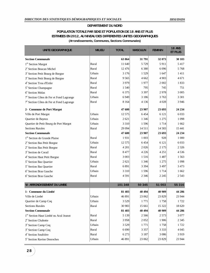
V- ARRONDISSEMENT DE BORGNE 111 464 55 698 55 766 54 337
1- Commune de Borgne 63 864 31 791 32 073 30 103
Ville de Borgne Urbain 6 949 3 186 3 763 3 301
Quartier de Petit Bourg de Borgne Urbain 3 176 1 529 1 647 1 411
Sections Rurales Rural 53 739 27 076 26 663 25 391
DEPARTEMENT DU NORD
POPULATION TOTALE PAR SEXE ET POPULATION DE 18 ANS ET PLUSESTIMEES EN 2012, AU NIVEAU DES DIFFERENTES UNITES GEOGRAPHIQUES
(Arrondissements, Communes, Sections Communales)
IHSI/DSDSDIRECTION DES STATISTIQUES DÉMOGRAPHIQUES ET SOCIALES
2 8
UNITE GEOGRAPHIQUE MILIEU TOTAL MASCULIN FEMININ18 ANSET PLUS
Section Communale 63 864 31 791 32 073 30 103
1re Section Margot Rural 11 640 5 729 5 911 5 417
2e Section Boucan Michel Rural 12 476 6 380 6 096 5 768
3e Section Petit Bourg de Borgne Urbain 3 176 1 529 1 647 1 411
3e Section Petit Bourg de Borgne Rural 9 565 4 662 4 903 4 671
4e Section Trou d'Enfer Rural 3 979 1 977 2 002 1 833
5e Section Champagne Rural 1 540 795 745 751
6e Section Molas Rural 6 375 3 397 2 978 3 005
7e Section Côtes de Fer et Fond Lagrange Urbain 6 949 3 186 3 763 3 301
7e Section Côtes de Fer et Fond Lagrange Rural 8 164 4 136 4 028 3 946
2- Commune de Port Margot 47 600 23 907 23 693 24 234
Ville de Port Margot Urbain 12 575 6 454 6 121 6 033
Quartier de Bayeux Urbain 2 621 1 346 1 275 1 098
Quartier de Petit Bourg de Port Margot Urbain 3 310 1 596 1 714 1 662
Sections Rurales Rural 29 094 14 511 14 583 15 441
Section Communale 47 600 23 907 23 693 24 234
1re Section de Grande Plaine Rural 1 931 1 003 928 1 000
2e Section Bas Petit Borgne Urbain 12 575 6 454 6 121 6 033
2e Section Bas Petit Borgne Rural 4 201 2 026 2 175 2 326
3e Section de Corail Rural 8 477 4 226 4 251 4 536
4e Section Haut Petit Borgne Rural 3 003 1 516 1 487 1 563
5e Section Bas Quartier Urbain 2 621 1 346 1 275 1 098
5e Section Bas Quartier Rural 6 891 3 394 3 497 3 473
6e Section Bras Gauche Urbain 3 310 1 596 1 714 1 662
6e Section Bras Gauche Rural 4 591 2 346 2 245 2 543
VI- ARRONDISSEMENT DU LIMBE 101 348 50 345 51 003 55 316
1- Commune du Limbé 81 403 40 494 40 909 44 286
Ville de Limbé Urbain 46 891 23 062 23 829 23 944
Quartier de Camp Coq Urbain 3 529 1 771 1 758 1 722
Sections Rurales Rural 30 983 15 661 15 322 18 620
Section Communale 81 403 40 494 40 909 44 286
1re Section Haut Limbé ou Acul Jeanot Rural 5 139 2 566 2 573 3 077
2e Section Chabotte Rural 3 958 2 052 1 906 2 345
3e Section Camp Coq Urbain 3 529 1 771 1 758 1 722
3e Section Camp Coq Rural 6 690 3 357 3 333 4 045
4e Section Soufrière Rural 6 273 3 187 3 086 3 919
5e Section Ravine Desroches Urbain 46 891 23 062 23 829 23 944
DEPARTEMENT DU NORD
POPULATION TOTALE PAR SEXE ET POPULATION DE 18 ANS ET PLUSESTIMEES EN 2012, AU NIVEAU DES DIFFERENTES UNITES GEOGRAPHIQUES
(Arrondissements, Communes, Sections Communales)
INSTITUT HAÏTIEN DE STATISTIQUE ET D’INFORMATIQUEJANVIER 2012
2 9POPULATION TOTALE, POPULATION DE 18 ANS ET PLUS ESTIMÉES EN 2012
UNITE GEOGRAPHIQUE MILIEU TOTAL MASCULIN FEMININ18 ANSET PLUS
5e Section Ravine Desroches Rural 6 320 3 161 3 159 3 685
6e Section Ilot-à-Corne Rural 2 603 1 338 1 265 1 549
2- Commune du Bas Limbé 19 945 9 851 10 094 11 030
Ville de Bas Limbé Urbain 7 714 3 767 3 947 3 659
Sections Rurales Rural 12 231 6 084 6 147 7 371
Section Communale 19 945 9 851 10 094 11 030
1re Section Garde Champètre (Bas Limbé) Rural 1 729 894 835 926
2e Section Petit Howars (la Fange) Urbain 7 714 3 767 3 947 3 659
2e Section Petit Howars (la Fange) Rural 10 502 5 190 5 312 6 445
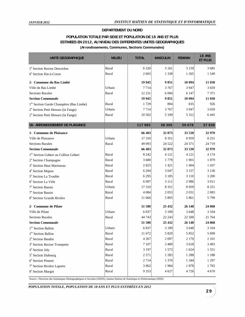
VII- ARRONDISSEMENT DE PLAISANCE 117 983 58 305 59 678 57 838
1- Commune de Plaisance 66 403 32 873 33 530 32 970
Ville de Plaisance Urbain 17 310 8 351 8 959 8 251
Sections Rurales Rural 49 093 24 522 24 571 24 719
Section Communale 66 403 32 873 33 530 32 970
1re Section Gobert ou Colline Gobert Rural 8 242 4 121 4 121 4 174
2e Section Champagne Rural 3 680 1 779 1 901 1 879
3e Section Haut Martineau Rural 2 825 1 421 1 404 1 437
4e Section Mapou Rural 6 204 3 047 3 157 3 136
5e Section La Trouble Rural 6 295 3 185 3 110 3 200
6e Section La Ville Rural 6 097 3 111 2 986 3 011
7e Section Bassin Urbain 17 310 8 351 8 959 8 251
7e Section Bassin Rural 4 084 2 053 2 031 2 083
8e Section Grande Rivière Rural 11 666 5 805 5 861 5 799
2- Commune de Pilate 51 580 25 432 26 148 24 868
Ville de Pilate Urbain 6 837 3 189 3 648 3 104
Sections Rurales Rural 44 743 22 243 22 500 21 764
Section Communale 51 580 25 432 26 148 24 868
1re Section Ballon Urbain 6 837 3 189 3 648 3 104
1re Section Ballon Rural 11 672 5 820 5 852 5 699
2e Section Baudin Rural 4 267 2 097 2 170 2 101
3e Section Ravine Trompette Rural 7 107 3 489 3 618 3 493
4e Section Joly Rural 3 197 1 573 1 624 1 551
5e Section Dubourg Rural 2 571 1 283 1 288 1 188
6e Section Piment Rural 2 714 1 370 1 344 1 297
7e Section Rivière Laporte Rural 3 862 1 984 1 878 1 765
8e Section Margot Rural 9 353 4 627 4 726 4 670
Source : Direction des Statistiques Démographiques et Sociales (DSDS), Institut Haïtien de Statistique et d'Informatique (IHSI)
DEPARTEMENT DU NORD
POPULATION TOTALE PAR SEXE ET POPULATION DE 18 ANS ET PLUSESTIMEES EN 2012, AU NIVEAU DES DIFFERENTES UNITES GEOGRAPHIQUES
(Arrondissements, Communes, Sections Communales)
IHSI/DSDSDIRECTION DES STATISTIQUES DÉMOGRAPHIQUES ET SOCIALES
3 0
UNITE GEOGRAPHIQUE MILIEU TOTAL MASCULIN FEMININ18 ANSET PLUS
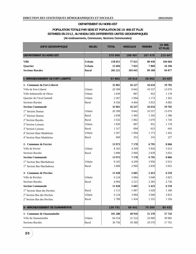
DEPARTEMENT DU NORD-EST 375 966 188 487 187 479 215 667
Ville Urbain 158 051 77 621 80 430 104 684
Quartier Urbain 15 694 7 825 7 869 16 106
Sections Rurales Rural 202 221 103 041 99 180 94 877
I- ARRONDISSEMENT DE FORT-LIBERTE 57 862 29 010 28 852 34 407
1- Commune de Fort-Liberté 32 861 16 227 16 634 19 782
Ville de Fort-Liberté Urbain 20 399 9 842 10 557 13 070
Ville Industrielle de Dérac Urbain 1 839 887 952 1 178
Quartier de l'Acul Samedi Urbain 2 267 1 094 1 173 1 452
Sections Rurales Rural 8 356 4 404 3 952 4 082
Section Communale 32 861 16 227 16 634 19 782
1re Section Dumas Urbain 20 399 9 842 10 557 13 070
1re Section Dumas Rural 2 838 1 495 1 343 1 386
2e Section Bayaha Rural 3 532 1 862 1 670 1 726
3e Section Loiseau Urbain 1 839 887 952 1 178
3e Section Loiseau Rural 1 317 694 623 643
4e Section Haut Madeleine Urbain 2 267 1 094 1 173 1 452
4e Section Haut Madeleine Rural 669 353 316 327
2- Commune de Ferrier 13 973 7 178 6 795 8 066
Ville de Ferrier Urbain 8 165 4 209 3 956 5 013
Sections Rurales Rural 5 808 2 969 2 839 3 053
Section Communale 13 973 7 178 6 795 8 066
1re Section Bas Maribahoux Urbain 8 165 4 209 3 956 5 013
1re Section Bas Maribahoux Rural 5 808 2 969 2 839 3 053
3- Commune de Perches 11 028 5 605 5 423 6 559
Ville de Perches Urbain 6 124 3 084 3 040 3 823
Sections Rurales Rural 4 904 2 521 2 383 2 736
Section Communale 11 028 5 605 5 423 6 559
1re Section Haut des Perches Rural 2 115 1 087 1 028 1 180
2e Section Bas des Perches Urbain 6 124 3 084 3 040 3 823
2e Section Bas des Perches Rural 2 789 1 434 1 355 1 556
II- ARRONDISSEMENT DE OUANAMINTHE 139 791 69 441 70 350 80 431
1- Commune de Ouanaminthe 101 280 49 910 51 370 57 743
Ville de Ouanaminthe Urbain 64 524 31 524 33 000 39 982
Sections Rurales Rural 36 756 18 386 18 370 17 761
DEPARTEMENT DU NORD-EST
POPULATION TOTALE PAR SEXE ET POPULATION DE 18 ANS ET PLUSESTIMEES EN 2012, AU NIVEAU DES DIFFERENTES UNITES GEOGRAPHIQUES
(Arrondissements, Communes, Sections Communales)
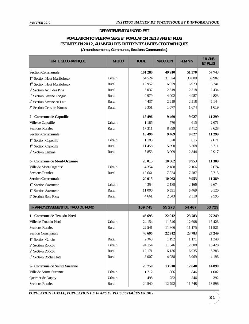
INSTITUT HAÏTIEN DE STATISTIQUE ET D’INFORMATIQUEJANVIER 2012
3 1POPULATION TOTALE, POPULATION DE 18 ANS ET PLUS ESTIMÉES EN 2012
UNITE GEOGRAPHIQUE MILIEU TOTAL MASCULIN FEMININ18 ANSET PLUS
Section Communale 101 280 49 910 51 370 57 743
1re Section Haut Maribahoux Urbain 64 524 31 524 33 000 39 982
1re Section Haut Maribahoux Rural 13 952 6 979 6 973 6 741
2e Section Acul des Pins Rural 5 037 2 519 2 518 2 434
3e Section Savane Longue Rural 9 979 4 992 4 987 4 823
4e Section Savane au Lait Rural 4 437 2 219 2 218 2 144
5e Section Gens de Nantes Rural 3 351 1 677 1 674 1 619
2- Commune de Capotille 18 496 9 469 9 027 11 299
Ville de Capotille Urbain 1 185 570 615 2 671
Sections Rurales Rural 17 311 8 899 8 412 8 628
Section Communale 18 496 9 469 9 027 11 299
1re Section Capotille Urbain 1 185 570 615 2 671
1re Section Capotille Rural 11 458 5 890 5 568 5 711
2e Section Lamine Rural 5 853 3 009 2 844 2 917
3- Commune de Mont-Organisé 20 015 10 062 9 953 11 389
Ville de Mont-Organisé Urbain 4 354 2 188 2 166 2 674
Sections Rurales Rural 15 661 7 874 7 787 8 715
Section Communale 20 015 10 062 9 953 11 389
1re Section Savanette Urbain 4 354 2 188 2 166 2 674
1re Section Savanette Rural 11 000 5 531 5 469 6 120
2e Section Bois Poux Rural 4 661 2 343 2 318 2 595
III- ARRONDISSEMENT DU TROU DU NORD 109 745 55 278 54 467 63 729
1- Commune de Trou du Nord 46 695 22 912 23 783 27 249
Ville de Trou du Nord Urbain 24 154 11 546 12 608 15 428
Sections Rurales Rural 22 541 11 366 11 175 11 821
Section Communale 46 695 22 912 23 783 27 249
1re Section Garcin Rural 2 363 1 192 1 171 1 240
2e Section Roucou Urbain 24 154 11 546 12 608 15 428
2e Section Roucou Rural 12 171 6 136 6 035 6 383
3e Section Roche Plate Rural 8 007 4 038 3 969 4 198
2- Commune de Sainte Suzanne 26 750 13 910 12 840 14 890
Ville de Sainte Suzanne Urbain 1 712 866 846 1 002
Quartier de Dupity Urbain 498 252 246 292
Sections Rurales Rural 24 540 12 792 11 748 13 596
DEPARTEMENT DU NORD-EST
POPULATION TOTALE PAR SEXE ET POPULATION DE 18 ANS ET PLUSESTIMEES EN 2012, AU NIVEAU DES DIFFERENTES UNITES GEOGRAPHIQUES
(Arrondissements, Communes, Sections Communales)
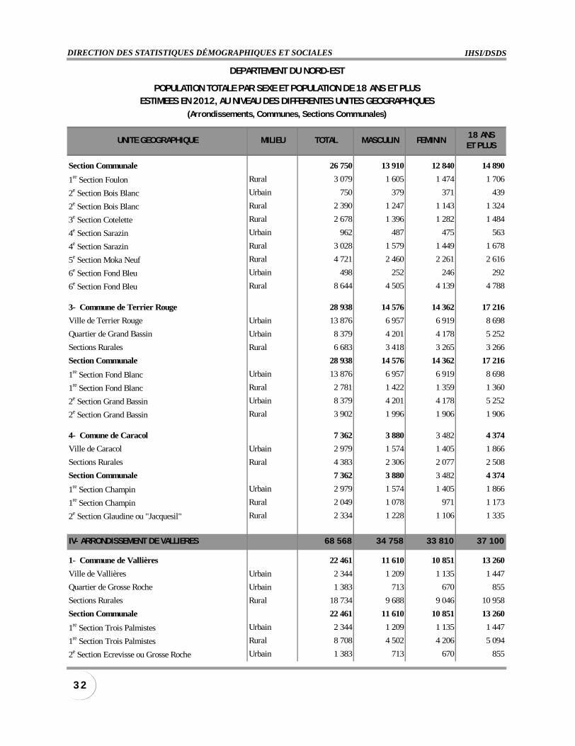
IHSI/DSDSDIRECTION DES STATISTIQUES DÉMOGRAPHIQUES ET SOCIALES
3 2
UNITE GEOGRAPHIQUE MILIEU TOTAL MASCULIN FEMININ18 ANSET PLUS
Section Communale 26 750 13 910 12 840 14 890
1re Section Foulon Rural 3 079 1 605 1 474 1 706
2e Section Bois Blanc Urbain 750 379 371 439
2e Section Bois Blanc Rural 2 390 1 247 1 143 1 324
3e Section Cotelette Rural 2 678 1 396 1 282 1 484
4e Section Sarazin Urbain 962 487 475 563
4e Section Sarazin Rural 3 028 1 579 1 449 1 678
5e Section Moka Neuf Rural 4 721 2 460 2 261 2 616
6e Section Fond Bleu Urbain 498 252 246 292
6e Section Fond Bleu Rural 8 644 4 505 4 139 4 788
3- Commune de Terrier Rouge 28 938 14 576 14 362 17 216
Ville de Terrier Rouge Urbain 13 876 6 957 6 919 8 698
Quartier de Grand Bassin Urbain 8 379 4 201 4 178 5 252
Sections Rurales Rural 6 683 3 418 3 265 3 266
Section Communale 28 938 14 576 14 362 17 216
1re Section Fond Blanc Urbain 13 876 6 957 6 919 8 698
1re Section Fond Blanc Rural 2 781 1 422 1 359 1 360
2e Section Grand Bassin Urbain 8 379 4 201 4 178 5 252
2e Section Grand Bassin Rural 3 902 1 996 1 906 1 906
4- Comune de Caracol 7 362 3 880 3 482 4 374
Ville de Caracol Urbain 2 979 1 574 1 405 1 866
Sections Rurales Rural 4 383 2 306 2 077 2 508
Section Communale 7 362 3 880 3 482 4 374
1re Section Champin Urbain 2 979 1 574 1 405 1 866
1re Section Champin Rural 2 049 1 078 971 1 173
2e Section Glaudine ou "Jacquesil" Rural 2 334 1 228 1 106 1 335
IV- ARRONDISSEMENT DE VALLIERES 68 568 34 758 33 810 37 100
1- Commune de Vallières 22 461 11 610 10 851 13 260
Ville de Vallières Urbain 2 344 1 209 1 135 1 447
Quartier de Grosse Roche Urbain 1 383 713 670 855
Sections Rurales Rural 18 734 9 688 9 046 10 958
Section Communale 22 461 11 610 10 851 13 260
1re Section Trois Palmistes Urbain 2 344 1 209 1 135 1 447
1re Section Trois Palmistes Rural 8 708 4 502 4 206 5 094
2e Section Ecrevisse ou Grosse Roche Urbain 1 383 713 670 855
DEPARTEMENT DU NORD-EST
POPULATION TOTALE PAR SEXE ET POPULATION DE 18 ANS ET PLUSESTIMEES EN 2012, AU NIVEAU DES DIFFERENTES UNITES GEOGRAPHIQUES
(Arrondissements, Communes, Sections Communales)
INSTITUT HAÏTIEN DE STATISTIQUE ET D’INFORMATIQUEJANVIER 2012
3 3POPULATION TOTALE, POPULATION DE 18 ANS ET PLUS ESTIMÉES EN 2012
UNITE GEOGRAPHIQUE MILIEU TOTAL MASCULIN FEMININ18 ANSET PLUS
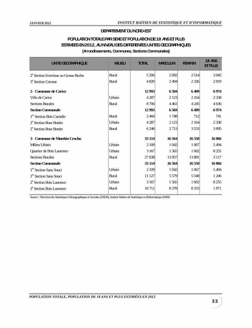
2e Section Ecrevisse ou Grosse Roche Rural 5 206 2 692 2 514 3 045
3e Section Corosse Rural 4 820 2 494 2 326 2 819
2- Commune de Carice 12 993 6 584 6 409 6 974
Ville de Carice Urbain 4 287 2 123 2 164 2 338
Sections Rurales Rural 8 706 4 461 4 245 4 636
Section Communale 12 993 6 584 6 409 6 974
1re Section Bois Camelle Rural 2 460 1 748 712 741
2e Section Rose Bonite Urbain 4 287 2 123 2 164 2 338
2e Section Rose Bonite Rural 6 246 2 713 3 533 3 895
3- Commune de Mombin Crochu 33 114 16 564 16 550 16 866
Milieu Urbain Urbain 2 109 1 042 1 067 5 494
Quartier de Bois Laurence Urbain 3 167 1 565 1 602 8 255
Sections Rurales Rural 27 838 13 957 13 881 3 117
Section Communale 33 114 16 564 16 550 16 866
1re Section Sans Souci Urbain 2 109 1 042 1 067 5 494
1re Section Sans Souci Rural 11 127 5 579 5 548 1 246
2e Section Bois Laurence Urbain 3 167 1 565 1 602 8 255
2e Section Bois Laurence Rural 16 711 8 378 8 333 1 871
Source : Direction des Statistiques Démographiques et Sociales (DSDS), Institut Haïtien de Statistique et d'Informatique (IHSI)
DEPARTEMENT DU NORD-EST
POPULATION TOTALE PAR SEXE ET POPULATION DE 18 ANS ET PLUSESTIMEES EN 2012, AU NIVEAU DES DIFFERENTES UNITES GEOGRAPHIQUES
(Arrondissements, Communes, Sections Communales)
IHSI/DSDSDIRECTION DES STATISTIQUES DÉMOGRAPHIQUES ET SOCIALES
3 4
UNITE GEOGRAPHIQUE MILIEU TOTAL MASCULIN FEMININ18 ANSET PLUS
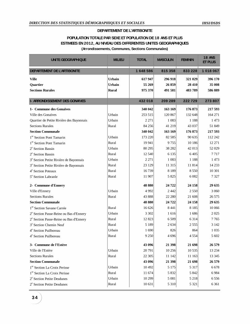
DEPARTEMENT DE L'ARTIBONITE 1 648 586 815 358 833 228 1 018 067
Ville Urbain 617 947 296 918 321 029 396 170
Quartier Urbain 55 269 26 859 28 410 35 008
Sections Rurales Rural 975 370 491 581 483 789 586 889
I- ARRONDISSEMENT DES GONAIVES 432 018 209 289 222 729 273 807
1- Commune des Gonaïves 340 042 163 169 176 873 217 593
Ville des Gonaïves Urbain 253 515 120 867 132 648 164 271
Quartier de Petite Rivière des Bayonnais Urbain 2 271 1 083 1 188 1 473
Sections Rurales Rural 84 256 41 219 43 037 51 849
Section Communale 340 042 163 169 176 873 217 593
1re Section Pont Tamarin Urbain 173 220 82 585 90 635 112 242
1re Section Pont Tamarin Rural 19 941 9 755 10 186 12 271
2e Section Bassin Urbain 80 295 38 282 42 013 52 029
2e Section Bassin Rural 12 540 6 135 6 405 7 717
3e Section Petite Rivière de Bayonnais Urbain 2 271 1 083 1 188 1 473
3e Section Petite Rivière de Bayonnais Rural 23 129 11 315 11 814 14 233
4e Section Poteaux Rural 16 739 8 189 8 550 10 301
5e Section Labranle Rural 11 907 5 825 6 082 7 327
2- Commune d'Ennery 48 880 24 722 24 158 29 635
Ville d'Ennery Urbain 4 992 2 442 2 550 3 060
Sections Rurales Rural 43 888 22 280 21 608 26 575
Section Communale 48 880 24 722 24 158 29 635
1re Section Savane Carrée Rural 16 626 8 441 8 185 10 066
2e Section Passe-Reine ou Bas d'Ennery Urbain 3 302 1 616 1 686 2 025
2e Section Passe-Reine ou Bas d'Ennery Rural 12 823 6 509 6 314 7 765
3e Section Chemin Neuf Rural 5 189 2 634 2 555 3 142
4e Section Puilboreau Urbain 1 690 826 864 1 035
4e Section Puilboreau Rural 9 250 4 696 4 554 5 602
3- Commune de l'Estère 43 096 21 398 21 698 26 579
Ville de l'Estère Urbain 20 791 10 256 10 535 13 234
Sections Rurales Rural 22 305 11 142 11 163 13 345
Section Communale 43 096 21 398 21 698 26 579
1re Section La Croix Perisse Urbain 10 492 5 175 5 317 6 678
1re Section La Croix Perisse Rural 11 674 5 832 5 842 6 984
2e Section Petite Desdunes Urbain 10 299 5 081 5 218 6 556
2e Section Petite Desdunes Rural 10 631 5 310 5 321 6 361
DEPARTEMENT DE L'ARTIBONITE
POPULATION TOTALE PAR SEXE ET POPULATION DE 18 ANS ET PLUSESTIMEES EN 2012, AU NIVEAU DES DIFFERENTES UNITES GEOGRAPHIQUES
(Arrondissements, Communes, Sections Communales)

INSTITUT HAÏTIEN DE STATISTIQUE ET D’INFORMATIQUEJANVIER 2012
3 5POPULATION TOTALE, POPULATION DE 18 ANS ET PLUS ESTIMÉES EN 2012
UNITE GEOGRAPHIQUE MILIEU TOTAL MASCULIN FEMININ18 ANSET PLUS
II- ARRONDISSEMENT DE GROS MORNE 219 813 110 572 109 241 132 641
1- Commune de Gros Morne 148 577 74 613 73 964 90 157
Ville de Gros Morne Urbain 33 797 16 327 17 470 21 065
Sections Rurales Rural 114 780 58 286 56 494 69 092
Section Communale 148 577 74 613 73 964 90 157
1re Section Boucan Richard Rural 7 708 3 915 3 793 4 641
2e Section Rivière Mancelle Rural 14 144 7 183 6 961 8 514
3e Section Rivière Blanche Urbain 33 797 16 327 17 470 21 065
3e Section Rivière Blanche Rural 14 254 7 238 7 016 8 580
4e Section L'Acul Rural 17 209 8 738 8 471 10 359
5e Section Pendu Rural 6 422 3 261 3 161 3 866
6e Section Savane Carrée Rural 23 506 11 937 11 569 14 148
7e Section Moulin Rural 15 400 7 820 7 580 9 270
8e Section Ravine Gros Morne Rural 16 137 8 194 7 943 9 714
2- Commune de Terre Neuve 29 824 15 203 14 621 17 193
Ville de Terre Neuve Urbain 1 443 796 647 887
Sections Rurales Rural 28 381 14 407 13 974 16 306
Section Communale 29 824 15 203 14 621 17 193
1re Section Doland Rural 11 382 5 778 5 604 6 540
2e Section Bois Neuf Urbain 1 443 796 647 887
2e Section Bois Neuf Rural 6 886 3 496 3 390 3 956
3e Section Lagon Rural 10 113 5 133 4 980 5 810
3- Commune de L'Anse Rouge 41 412 20 756 20 656 25 291
Ville de L'Anse Rouge Urbain 1 270 627 643 769
Quartier de Sources Chaudes Urbain 12 788 6 311 6 477 7 739
Sections Rurales Rural 27 354 13 818 13 536 16 783
Section Communale 41 412 20 756 20 656 25 291
1re Section L'Arbre Urbain 1 270 627 643 769
1re Section L'Arbre Rural 15 906 8 035 7 871 9 760
2e Section Sources Chaudes Urbain 12 788 6 311 6 477 7 739
2e Section Sources Chaudes Rural 11 448 5 783 5 665 7 023
III- ARRONDISSEMENT DE SAINT-MARC 422 765 207 313 215 452 265 887
1- Commune de Saint-Marc 254 458 123 178 131 280 162 828
Ville de Saint-Marc Urbain 136 187 63 981 72 206 89 390
Quartier de Montrouis Urbain 7 853 3 689 4 164 5 155
Sections Rurales Rural 110 418 55 508 54 910 68 283
DEPARTEMENT DE L'ARTIBONITE
POPULATION TOTALE PAR SEXE ET POPULATION DE 18 ANS ET PLUSESTIMEES EN 2012, AU NIVEAU DES DIFFERENTES UNITES GEOGRAPHIQUES
(Arrondissements, Communes, Sections Communales)
IHSI/DSDSDIRECTION DES STATISTIQUES DÉMOGRAPHIQUES ET SOCIALES
3 6
UNITE GEOGRAPHIQUE MILIEU TOTAL MASCULIN FEMININ18 ANSET PLUS
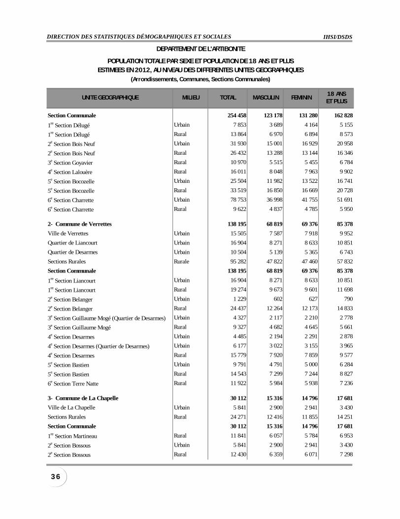
Section Communale 254 458 123 178 131 280 162 828
1re Section Délugé Urbain 7 853 3 689 4 164 5 155
1re Section Délugé Rural 13 864 6 970 6 894 8 573
2e Section Bois Neuf Urbain 31 930 15 001 16 929 20 958
2e Section Bois Neuf Rural 26 432 13 288 13 144 16 346
3e Section Goyavier Rural 10 970 5 515 5 455 6 784
4e Section Lalouère Rural 16 011 8 048 7 963 9 902
5e Section Bocozelle Urbain 25 504 11 982 13 522 16 741
5e Section Bocozelle Rural 33 519 16 850 16 669 20 728
6e Section Charrette Urbain 78 753 36 998 41 755 51 691
6e Section Charrette Rural 9 622 4 837 4 785 5 950
2- Commune de Verrettes 138 195 68 819 69 376 85 378
Ville de Verrettes Urbain 15 505 7 587 7 918 9 952
Quartier de Liancourt Urbain 16 904 8 271 8 633 10 851
Quartier de Desarmes Urbain 10 504 5 139 5 365 6 743
Sections Rurales Rurale 95 282 47 822 47 460 57 832
Section Communale 138 195 68 819 69 376 85 378
1re Section Liancourt Urbain 16 904 8 271 8 633 10 851
1re Section Liancourt Rural 19 274 9 673 9 601 11 698
2e Section Belanger Urbain 1 229 602 627 790
2e Section Belanger Rural 24 437 12 264 12 173 14 833
3e Section Guillaume Mogé (Quartier de Desarmes) Urbain 4 327 2 117 2 210 2 778
3e Section Guillaume Mogé Rural 9 327 4 682 4 645 5 661
4e Section Desarmes Urbain 4 485 2 194 2 291 2 878
4e Section Desarmes (Quartier de Desarmes) Urbain 6 177 3 022 3 155 3 965
4e Section Desarmes Rural 15 779 7 920 7 859 9 577
5e Section Bastien Urbain 9 791 4 791 5 000 6 284
5e Section Bastien Rural 14 543 7 299 7 244 8 827
6e Section Terre Natte Rural 11 922 5 984 5 938 7 236
3- Commune de La Chapelle 30 112 15 316 14 796 17 681
Ville de La Chapelle Urbain 5 841 2 900 2 941 3 430
Sections Rurales Rural 24 271 12 416 11 855 14 251
Section Communale 30 112 15 316 14 796 17 681
1re Section Martineau Rural 11 841 6 057 5 784 6 953
2e Section Bossous Urbain 5 841 2 900 2 941 3 430
2e Section Bossous Rural 12 430 6 359 6 071 7 298
DEPARTEMENT DE L'ARTIBONITE
POPULATION TOTALE PAR SEXE ET POPULATION DE 18 ANS ET PLUSESTIMEES EN 2012, AU NIVEAU DES DIFFERENTES UNITES GEOGRAPHIQUES
(Arrondissements, Communes, Sections Communales)
INSTITUT HAÏTIEN DE STATISTIQUE ET D’INFORMATIQUEJANVIER 2012
3 7POPULATION TOTALE, POPULATION DE 18 ANS ET PLUS ESTIMÉES EN 2012
UNITE GEOGRAPHIQUE MILIEU TOTAL MASCULIN FEMININ18 ANSET PLUS
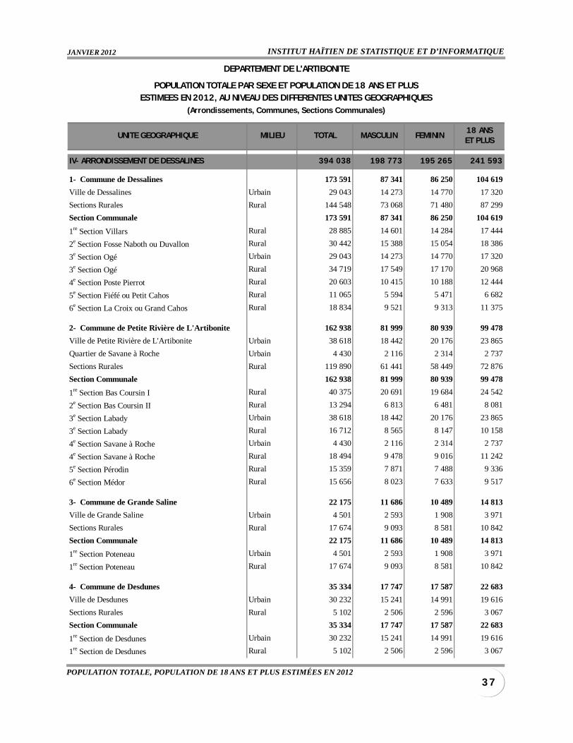
IV- ARRONDISSEMENT DE DESSALINES 394 038 198 773 195 265 241 593
1- Commune de Dessalines 173 591 87 341 86 250 104 619
Ville de Dessalines Urbain 29 043 14 273 14 770 17 320
Sections Rurales Rural 144 548 73 068 71 480 87 299
Section Communale 173 591 87 341 86 250 104 619
1re Section Villars Rural 28 885 14 601 14 284 17 444
2e Section Fosse Naboth ou Duvallon Rural 30 442 15 388 15 054 18 386
3e Section Ogé Urbain 29 043 14 273 14 770 17 320
3e Section Ogé Rural 34 719 17 549 17 170 20 968
4e Section Poste Pierrot Rural 20 603 10 415 10 188 12 444
5e Section Fiéfé ou Petit Cahos Rural 11 065 5 594 5 471 6 682
6e Section La Croix ou Grand Cahos Rural 18 834 9 521 9 313 11 375
2- Commune de Petite Rivière de L'Artibonite 162 938 81 999 80 939 99 478
Ville de Petite Rivière de L'Artibonite Urbain 38 618 18 442 20 176 23 865
Quartier de Savane à Roche Urbain 4 430 2 116 2 314 2 737
Sections Rurales Rural 119 890 61 441 58 449 72 876
Section Communale 162 938 81 999 80 939 99 478
1re Section Bas Coursin I Rural 40 375 20 691 19 684 24 542
2e Section Bas Coursin II Rural 13 294 6 813 6 481 8 081
3e Section Labady Urbain 38 618 18 442 20 176 23 865
3e Section Labady Rural 16 712 8 565 8 147 10 158
4e Section Savane à Roche Urbain 4 430 2 116 2 314 2 737
4e Section Savane à Roche Rural 18 494 9 478 9 016 11 242
5e Section Pérodin Rural 15 359 7 871 7 488 9 336
6e Section Médor Rural 15 656 8 023 7 633 9 517
3- Commune de Grande Saline 22 175 11 686 10 489 14 813
Ville de Grande Saline Urbain 4 501 2 593 1 908 3 971
Sections Rurales Rural 17 674 9 093 8 581 10 842
Section Communale 22 175 11 686 10 489 14 813
1re Section Poteneau Urbain 4 501 2 593 1 908 3 971
1re Section Poteneau Rural 17 674 9 093 8 581 10 842
4- Commune de Desdunes 35 334 17 747 17 587 22 683
Ville de Desdunes Urbain 30 232 15 241 14 991 19 616
Sections Rurales Rural 5 102 2 506 2 596 3 067
Section Communale 35 334 17 747 17 587 22 683
1re Section de Desdunes Urbain 30 232 15 241 14 991 19 616
1re Section de Desdunes Rural 5 102 2 506 2 596 3 067
DEPARTEMENT DE L'ARTIBONITE
POPULATION TOTALE PAR SEXE ET POPULATION DE 18 ANS ET PLUSESTIMEES EN 2012, AU NIVEAU DES DIFFERENTES UNITES GEOGRAPHIQUES
(Arrondissements, Communes, Sections Communales)
IHSI/DSDSDIRECTION DES STATISTIQUES DÉMOGRAPHIQUES ET SOCIALES
3 8
UNITE GEOGRAPHIQUE MILIEU TOTAL MASCULIN FEMININ18 ANSET PLUS
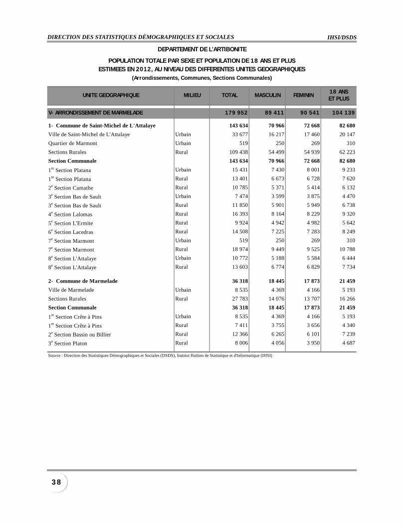
V- ARRONDISSEMENT DE MARMELADE 179 952 89 411 90 541 104 139
1- Commune de Saint-Michel de L'Attalaye 143 634 70 966 72 668 82 680
Ville de Saint-Michel de L'Attalaye Urbain 33 677 16 217 17 460 20 147
Quartier de Marmont Urbain 519 250 269 310
Sections Rurales Rural 109 438 54 499 54 939 62 223
Section Communale 143 634 70 966 72 668 82 680
1re Section Platana Urbain 15 431 7 430 8 001 9 233
1re Section Platana Rural 13 401 6 673 6 728 7 620
2e Section Camathe Rural 10 785 5 371 5 414 6 132
3e Section Bas de Sault Urbain 7 474 3 599 3 875 4 470
3e Section Bas de Sault Rural 11 850 5 901 5 949 6 738
4e Section Lalomas Rural 16 393 8 164 8 229 9 320
5e Section L'Ermite Rural 9 924 4 942 4 982 5 642
6e Section Lacedras Rural 14 508 7 225 7 283 8 249
7e Section Marmont Urbain 519 250 269 310
7e Section Marmont Rural 18 974 9 449 9 525 10 788
8e Section L'Attalaye Urbain 10 772 5 188 5 584 6 444
8e Section L'Attalaye Rural 13 603 6 774 6 829 7 734
2- Commune de Marmelade 36 318 18 445 17 873 21 459
Ville de Marmelade Urbain 8 535 4 369 4 166 5 193
Sections Rurales Rural 27 783 14 076 13 707 16 266
Section Communale 36 318 18 445 17 873 21 459
1re Section Crête à Pins Urbain 8 535 4 369 4 166 5 193
1re Section Crête à Pins Rural 7 411 3 755 3 656 4 340
2e Section Bassin ou Billier Rural 12 366 6 265 6 101 7 239
3e Section Platon Rural 8 006 4 056 3 950 4 687
Source : Direction des Statistiques Démographiques et Sociales (DSDS), Institut Haïtien de Statistique et d'Informatique (IHSI)
DEPARTEMENT DE L'ARTIBONITE
POPULATION TOTALE PAR SEXE ET POPULATION DE 18 ANS ET PLUSESTIMEES EN 2012, AU NIVEAU DES DIFFERENTES UNITES GEOGRAPHIQUES
(Arrondissements, Communes, Sections Communales)
INSTITUT HAÏTIEN DE STATISTIQUE ET D’INFORMATIQUEJANVIER 2012
3 9POPULATION TOTALE, POPULATION DE 18 ANS ET PLUS ESTIMÉES EN 2012
UNITE GEOGRAPHIQUE MILIEU TOTAL MASCULIN FEMININ18 ANSET PLUS
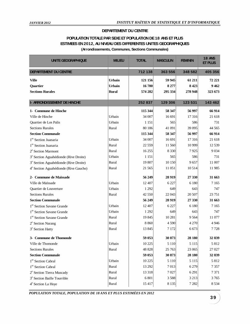
DEPARTEMENT DU CENTRE 712 138 363 556 348 582 405 356
Ville Urbain 121 156 59 945 61 211 72 221
Quartier Urbain 16 700 8 277 8 423 9 462
Sections Rurales Rural 574 282 295 334 278 948 323 673
I- ARRONDISSEMENT DE HINCHE 252 837 129 306 123 531 143 462
1- Commune de Hinche 115 344 58 347 56 997 66 914
Ville de Hinche Urbain 34 007 16 691 17 316 21 618
Quartier de Los Palis Urbain 1 151 565 586 731
Sections Rurales Rural 80 186 41 091 39 095 44 565
Section Communale 115 344 58 347 56 997 66 914
1re Section Juanaria Urbain 34 007 16 691 17 316 21 618
1re Section Juanaria Rural 22 559 11 560 10 999 12 539
2e Section Marmont Rural 16 255 8 330 7 925 9 034
3e Section Aguahédionde (Rive Droite) Urbain 1 151 565 586 731
3e Section Aguahédionde (Rive Droite) Rural 19 807 10 150 9 657 11 007
4e Section Aguahédionde (Rive Gauche) Rural 21 565 11 051 10 514 11 985
2- Commune de Maïssade 56 249 28 919 27 330 31 663
Ville de Maïssade Urbain 12 407 6 227 6 180 7 165
Quartier de Louverture Urbain 1 292 649 643 747
Sections Rurales Rural 42 550 22 043 20 507 23 751
Section Communale 56 249 28 919 27 330 31 663
1re Section Savane Grande Urbain 12 407 6 227 6 180 7 165
1re Section Savane Grande Urbain 1 292 649 643 747
1re Section Savane Grande Rural 19 845 10 281 9 564 11 077
2e Section Narang Rural 8 860 4 590 4 270 4 946
3e Section Hatty Rural 13 845 7 172 6 673 7 728
3- Commune de Thomonde 59 053 30 873 28 180 32 839
Ville de Thomonde Urbain 10 225 5 110 5 115 5 812
Sections Rurales Rural 48 828 25 763 23 065 27 027
Section Communale 59 053 30 873 28 180 32 839
1re Section Cabral Urbain 10 225 5 110 5 115 5 812
1re Section Cabral Rural 13 292 7 013 6 279 7 357
2e Section Tierra Muscady Rural 13 318 7 027 6 291 7 371
3e Section Baille Tourrible Rural 6 801 3 588 3 213 3 765
4e Section La Hoye Rural 15 417 8 135 7 282 8 534
DEPARTEMENT DU CENTRE
POPULATION TOTALE PAR SEXE ET POPULATION DE 18 ANS ET PLUSESTIMEES EN 2012, AU NIVEAU DES DIFFERENTES UNITES GEOGRAPHIQUES
(Arrondissements, Communes, Sections Communales)
IHSI/DSDSDIRECTION DES STATISTIQUES DÉMOGRAPHIQUES ET SOCIALES
4 0
UNITE GEOGRAPHIQUE MILIEU TOTAL MASCULIN FEMININ18 ANSET PLUS
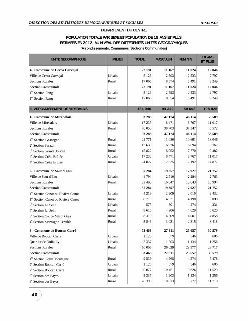
4- Commune de Cerca Carvajal 22 191 11 167 11 024 12 046
Ville de Cerca Carvajal Urbain 5 126 2 593 2 533 2 797
Sections Rurales Rural 17 065 8 574 8 491 9 249
Section Communale 22 191 11 167 11 024 12 046
1re Section Rang Urbain 5 126 2 593 2 533 2 797
1re Section Rang Rural 17 065 8 574 8 491 9 249
II- ARRONDISSEMENT DE MIREBALAIS 184 040 94 342 89 698 108 925
1- Commune de Mirebalais 93 288 47 174 46 114 56 589
Ville de Mirebalais Urbain 17 238 8 471 8 767 11 017
Sections Rurales Rural 76 050 38 703 37 347 45 572
Section Communale 93 288 47 174 46 114 56 589
1re Section Gascogne Rural 21 771 11 080 10 691 13 046
2e Section Sarazin Rural 13 630 6 936 6 694 8 167
3e Section Grand Boucan Rural 15 822 8 052 7 770 9 482
4e Section Crête Brûlée Urbain 17 238 8 471 8 767 11 017
4e Section Crête Brûlée Rural 24 827 12 635 12 192 14 877
2- Commune de Saut d'Eau 37 284 19 357 17 927 21 757
Ville de Saut d'Eau Urbain 4 794 2 510 2 284 2 763
Sections Rurales Rural 32 490 16 847 15 643 18 994
Section Communale 37 284 19 357 17 927 21 757
1re Section Canot ou Rivière Canot Urbain 4 219 2 209 2 010 2 432
1re Section Canot ou Rivière Canot Rural 8 719 4 521 4 198 5 098
2e Section La Selle Urbain 575 301 274 331
2e Section La Selle Rural 9 615 4 986 4 629 5 620
3e Section Coupe Mardi Gras Rural 8 310 4 309 4 001 4 858
4e Section Montagne Terrible Rural 5 846 3 031 2 815 3 418
3- Commune de Boucan Carré 53 468 27 811 25 657 30 579
Ville de Boucan Carré Urbain 1 125 579 546 606
Quartier de Duffailly Urbain 2 337 1 203 1 134 1 256
Sections Rurales Rural 50 006 26 029 23 977 28 717
Section Communale 53 468 27 811 25 657 30 579
1re Section Petite Montagne Rural 9 539 4 965 4 574 5 478
2e Section Boucan Carré Urbain 1 125 579 546 606
2e Section Boucan Carré Rural 20 077 10 451 9 626 11 529
3e Section des Bayes Urbain 2 337 1 203 1 134 1 256
3e Section des Bayes Rural 20 390 10 613 9 777 11 710
DEPARTEMENT DU CENTRE
POPULATION TOTALE PAR SEXE ET POPULATION DE 18 ANS ET PLUSESTIMEES EN 2012, AU NIVEAU DES DIFFERENTES UNITES GEOGRAPHIQUES
(Arrondissements, Communes, Sections Communales)
INSTITUT HAÏTIEN DE STATISTIQUE ET D’INFORMATIQUEJANVIER 2012
4 1POPULATION TOTALE, POPULATION DE 18 ANS ET PLUS ESTIMÉES EN 2012
UNITE GEOGRAPHIQUE MILIEU TOTAL MASCULIN FEMININ18 ANSET PLUS
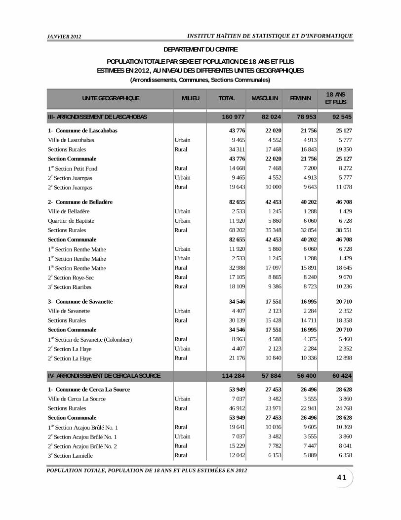
III- ARRONDISSEMENT DE LASCAHOBAS 160 977 82 024 78 953 92 545
1- Commune de Lascahobas 43 776 22 020 21 756 25 127
Ville de Lascohabas Urbain 9 465 4 552 4 913 5 777
Sections Rurales Rural 34 311 17 468 16 843 19 350
Section Communale 43 776 22 020 21 756 25 127
1re Section Petit Fond Rural 14 668 7 468 7 200 8 272
2e Section Juampas Urbain 9 465 4 552 4 913 5 777
2e Section Juampas Rural 19 643 10 000 9 643 11 078
2- Commune de Belladère 82 655 42 453 40 202 46 708
Ville de Belladère Urbain 2 533 1 245 1 288 1 429
Quartier de Baptiste Urbain 11 920 5 860 6 060 6 728
Sections Rurales Rural 68 202 35 348 32 854 38 551
Section Communale 82 655 42 453 40 202 46 708
1re Section Renthe Mathe Urbain 11 920 5 860 6 060 6 728
1re Section Renthe Mathe Urbain 2 533 1 245 1 288 1 429
1re Section Renthe Mathe Rural 32 988 17 097 15 891 18 645
2e Section Roye-Sec Rural 17 105 8 865 8 240 9 670
3e Section Riaribes Rural 18 109 9 386 8 723 10 236
3- Commune de Savanette 34 546 17 551 16 995 20 710
Ville de Savanette Urbain 4 407 2 123 2 284 2 352
Sections Rurales Rural 30 139 15 428 14 711 18 358
Section Communale 34 546 17 551 16 995 20 710
1re Section de Savanette (Colombier) Rural 8 963 4 588 4 375 5 460
2e Section La Haye Urbain 4 407 2 123 2 284 2 352
2e Section La Haye Rural 21 176 10 840 10 336 12 898
IV- ARRONDISSEMENT DE CERCA LA SOURCE 114 284 57 884 56 400 60 424
1- Commune de Cerca La Source 53 949 27 453 26 496 28 628
Ville de Cerca La Source Urbain 7 037 3 482 3 555 3 860
Sections Rurales Rural 46 912 23 971 22 941 24 768
Section Communale 53 949 27 453 26 496 28 628
1re Section Acajou Brûlé No. 1 Rural 19 641 10 036 9 605 10 369
2e Section Acajou Brûlé No. 1 Urbain 7 037 3 482 3 555 3 860
2e Section Acajou Brûlé No. 2 Rural 15 229 7 782 7 447 8 041
3e Section Lamielle Rural 12 042 6 153 5 889 6 358
DEPARTEMENT DU CENTRE
POPULATION TOTALE PAR SEXE ET POPULATION DE 18 ANS ET PLUSESTIMEES EN 2012, AU NIVEAU DES DIFFERENTES UNITES GEOGRAPHIQUES
(Arrondissements, Communes, Sections Communales)
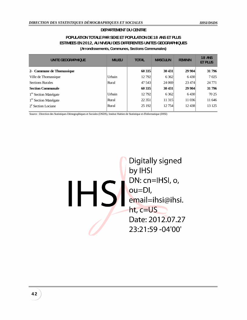
IHSI/DSDSDIRECTION DES STATISTIQUES DÉMOGRAPHIQUES ET SOCIALES
4 2
UNITE GEOGRAPHIQUE MILIEU TOTAL MASCULIN FEMININ18 ANSET PLUS
2- Commune de Thomassique 60 335 30 431 29 904 31 796
Ville de Thomassique Urbain 12 792 6 362 6 430 7 025
Sections Rurales Rural 47 543 24 069 23 474 24 771
Section Communale 60 335 30 431 29 904 31 796
1re Section Matelgate Urbain 12 792 6 362 6 430 70 25
1re Section Matelgate Rural 22 351 11 315 11 036 11 646
2e Section Lociane Rural 25 192 12 754 12 438 13 125
Source : Direction des Statistiques Démographiques et Sociales (DSDS), Institut Haïtien de Statistique et d'Informatique (IHSI)
DEPARTEMENT DU CENTRE
POPULATION TOTALE PAR SEXE ET POPULATION DE 18 ANS ET PLUSESTIMEES EN 2012, AU NIVEAU DES DIFFERENTES UNITES GEOGRAPHIQUES
(Arrondissements, Communes, Sections Communales)
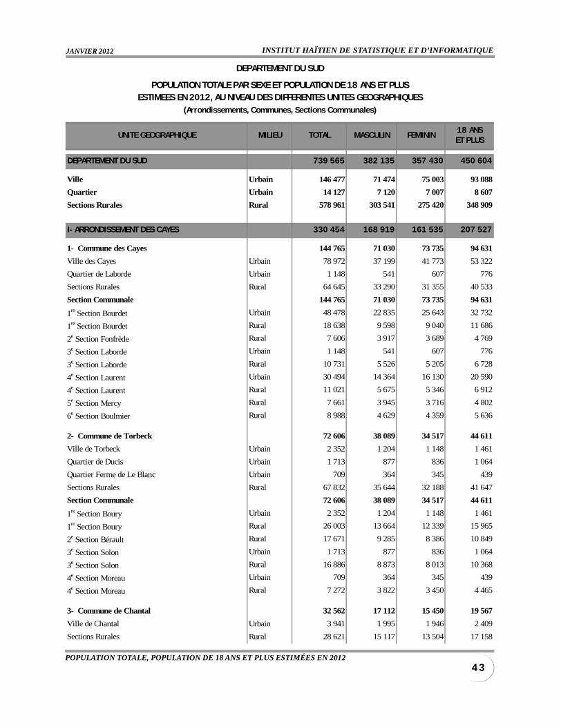
INSTITUT HAÏTIEN DE STATISTIQUE ET D’INFORMATIQUEJANVIER 2012
4 3POPULATION TOTALE, POPULATION DE 18 ANS ET PLUS ESTIMÉES EN 2012
UNITE GEOGRAPHIQUE MILIEU TOTAL MASCULIN FEMININ18 ANSET PLUS
DEPARTEMENT DU SUD 739 565 382 135 357 430 450 604
Ville Urbain 146 477 71 474 75 003 93 088
Quartier Urbain 14 127 7 120 7 007 8 607
Sections Rurales Rural 578 961 303 541 275 420 348 909
I- ARRONDISSEMENT DES CAYES 330 454 168 919 161 535 207 527
1- Commune des Cayes 144 765 71 030 73 735 94 631
Ville des Cayes Urbain 78 972 37 199 41 773 53 322
Quartier de Laborde Urbain 1 148 541 607 776
Sections Rurales Rural 64 645 33 290 31 355 40 533
Section Communale 144 765 71 030 73 735 94 631
1re Section Bourdet Urbain 48 478 22 835 25 643 32 732
1re Section Bourdet Rural 18 638 9 598 9 040 11 686
2e Section Fonfrède Rural 7 606 3 917 3 689 4 769
3e Section Laborde Urbain 1 148 541 607 776
3e Section Laborde Rural 10 731 5 526 5 205 6 728
4e Section Laurent Urbain 30 494 14 364 16 130 20 590
4e Section Laurent Rural 11 021 5 675 5 346 6 912
5e Section Mercy Rural 7 661 3 945 3 716 4 802
6e Section Boulmier Rural 8 988 4 629 4 359 5 636
2- Commune de Torbeck 72 606 38 089 34 517 44 611
Ville de Torbeck Urbain 2 352 1 204 1 148 1 461
Quartier de Ducis Urbain 1 713 877 836 1 064
Quartier Ferme de Le Blanc Urbain 709 364 345 439
Sections Rurales Rural 67 832 35 644 32 188 41 647
Section Communale 72 606 38 089 34 517 44 611
1re Section Boury Urbain 2 352 1 204 1 148 1 461
1re Section Boury Rural 26 003 13 664 12 339 15 965
2e Section Bérault Rural 17 671 9 285 8 386 10 849
3e Section Solon Urbain 1 713 877 836 1 064
3e Section Solon Rural 16 886 8 873 8 013 10 368
4e Section Moreau Urbain 709 364 345 439
4e Section Moreau Rural 7 272 3 822 3 450 4 465
3- Commune de Chantal 32 562 17 112 15 450 19 567
Ville de Chantal Urbain 3 941 1 995 1 946 2 409
Sections Rurales Rural 28 621 15 117 13 504 17 158
DEPARTEMENT DU SUD
POPULATION TOTALE PAR SEXE ET POPULATION DE 18 ANS ET PLUSESTIMEES EN 2012, AU NIVEAU DES DIFFERENTES UNITES GEOGRAPHIQUES
(Arrondissements, Communes, Sections Communales)
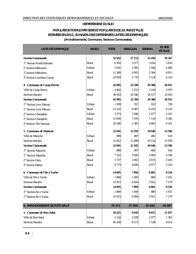
IHSI/DSDSDIRECTION DES STATISTIQUES DÉMOGRAPHIQUES ET SOCIALES
4 4
UNITE GEOGRAPHIQUE MILIEU TOTAL MASCULIN FEMININ18 ANSET PLUS
Section Communale 32 562 17 112 15 450 19 567
1re Section Fonds Palmiste Rural 6 393 3 377 3 016 3 833
2e Section Melonière Urbain 3 941 1 995 1 946 2 409
2e Section Melonière Rural 11 369 6 005 5 364 6 815
3e Section Carrefour Canon Rural 10 859 5 735 5 124 6 510
4- Commune de Camp-Perrin 42 985 22 599 20 386 26 912
Ville de Camp-Perrin Urbain 4 482 2 253 2 229 2 979
Sections Rurales Rural 38 503 20 346 18 157 23 933
Section Communale 42 985 22 599 20 386 26 912
1re Section Levy Mersan Urbain 1 109 557 552 738
1re Section Levy Mersan Rural 13 222 6 987 6 235 8 219
2e Section Champlois Urbain 3 373 1 696 1 677 2 241
2e Section Champlois Rural 15 095 7 976 7 119 9 383
3e Section Tibi Davezac Rural 10 186 5 383 4 803 6 331
5- Commune de Maniche 22 841 12 195 10 646 13 596
Ville de Maniche Urbain 989 497 492 618
Sections Rurales Rural 21 852 11 698 10 154 12 978
Section Communale 22 841 12 195 10 646 13 596
1re Section Maniche Urbain 989 497 492 618
1re Section Maniche Rural 7 322 3 920 3 402 4 349
2e Section Dory Rural 5 757 3 082 2 675 3 419
3e Section Melon Rural 8 773 4 696 4 077 5 210
6- Commune de l'Ile à Vache 14 695 7 894 6 801 8 210
Ville de l'Ile à Vache Urbain 1 880 1 000 880 1 031
Sections Rurales Rural 12 815 6 894 5 921 7 179
Section Communale 14 695 7 894 6 801 8 210
1re Section Ile à Vache Urbain 1 880 1 000 880 1 031
1re Section Ile à Vache Rural 12 815 6 894 5 921 7 179
II- ARRONDISSEMENT DE PORT-SALUT 70 471 37 839 32 632 42 897
1- Commune de Port-Salut 18 225 9 610 8 615 11 037
Ville de Port-Salut Urbain 2 116 1 039 1 077 1 363
Sections Rurales Rural 16 109 8 571 7 538 9 674
DEPARTEMENT DU SUD
POPULATION TOTALE PAR SEXE ET POPULATION DE 18 ANS ET PLUSESTIMEES EN 2012, AU NIVEAU DES DIFFERENTES UNITES GEOGRAPHIQUES
(Arrondissements, Communes, Sections Communales)
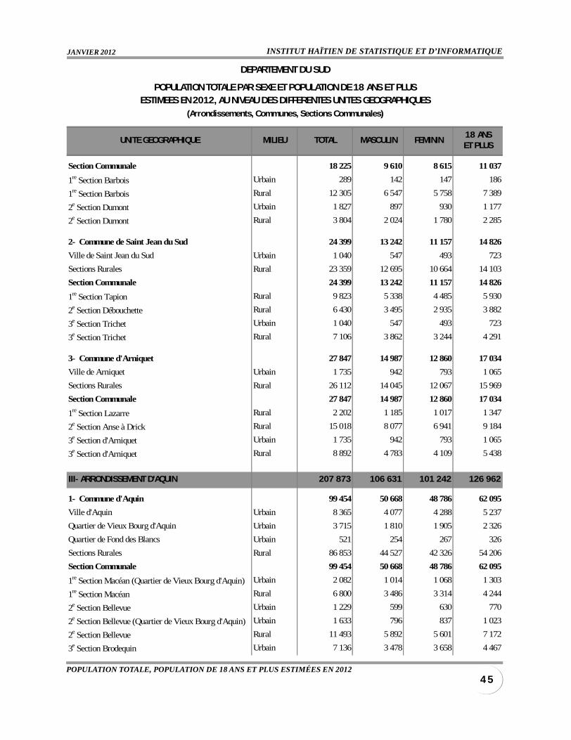
INSTITUT HAÏTIEN DE STATISTIQUE ET D’INFORMATIQUEJANVIER 2012
4 5POPULATION TOTALE, POPULATION DE 18 ANS ET PLUS ESTIMÉES EN 2012
UNITE GEOGRAPHIQUE MILIEU TOTAL MASCULIN FEMININ18 ANSET PLUS
Section Communale 18 225 9 610 8 615 11 037
1re Section Barbois Urbain 289 142 147 186
1re Section Barbois Rural 12 305 6 547 5 758 7 389
2e Section Dumont Urbain 1 827 897 930 1 177
2e Section Dumont Rural 3 804 2 024 1 780 2 285
2- Commune de Saint Jean du Sud 24 399 13 242 11 157 14 826
Ville de Saint Jean du Sud Urbain 1 040 547 493 723
Sections Rurales Rural 23 359 12 695 10 664 14 103
Section Communale 24 399 13 242 11 157 14 826
1re Section Tapion Rural 9 823 5 338 4 485 5 930
2e Section Débouchette Rural 6 430 3 495 2 935 3 882
3e Section Trichet Urbain 1 040 547 493 723
3e Section Trichet Rural 7 106 3 862 3 244 4 291
3- Commune d'Arniquet 27 847 14 987 12 860 17 034
Ville de Arniquet Urbain 1 735 942 793 1 065
Sections Rurales Rural 26 112 14 045 12 067 15 969
Section Communale 27 847 14 987 12 860 17 034
1re Section Lazarre Rural 2 202 1 185 1 017 1 347
2e Section Anse à Drick Rural 15 018 8 077 6 941 9 184
3e Section d'Arniquet Urbain 1 735 942 793 1 065
3e Section d'Arniquet Rural 8 892 4 783 4 109 5 438
III- ARRONDISSEMENT D'AQUIN 207 873 106 631 101 242 126 962
1- Commune d'Aquin 99 454 50 668 48 786 62 095
Ville d'Aquin Urbain 8 365 4 077 4 288 5 237
Quartier de Vieux Bourg d'Aquin Urbain 3 715 1 810 1 905 2 326
Quartier de Fond des Blancs Urbain 521 254 267 326
Sections Rurales Rural 86 853 44 527 42 326 54 206
Section Communale 99 454 50 668 48 786 62 095
1re Section Macéan (Quartier de Vieux Bourg d'Aquin) Urbain 2 082 1 014 1 068 1 303
1re Section Macéan Rural 6 800 3 486 3 314 4 244
2e Section Bellevue Urbain 1 229 599 630 770
2e Section Bellevue (Quartier de Vieux Bourg d'Aquin) Urbain 1 633 796 837 1 023
2e Section Bellevue Rural 11 493 5 892 5 601 7 172
3e Section Brodequin Urbain 7 136 3 478 3 658 4 467
DEPARTEMENT DU SUD
POPULATION TOTALE PAR SEXE ET POPULATION DE 18 ANS ET PLUSESTIMEES EN 2012, AU NIVEAU DES DIFFERENTES UNITES GEOGRAPHIQUES
(Arrondissements, Communes, Sections Communales)
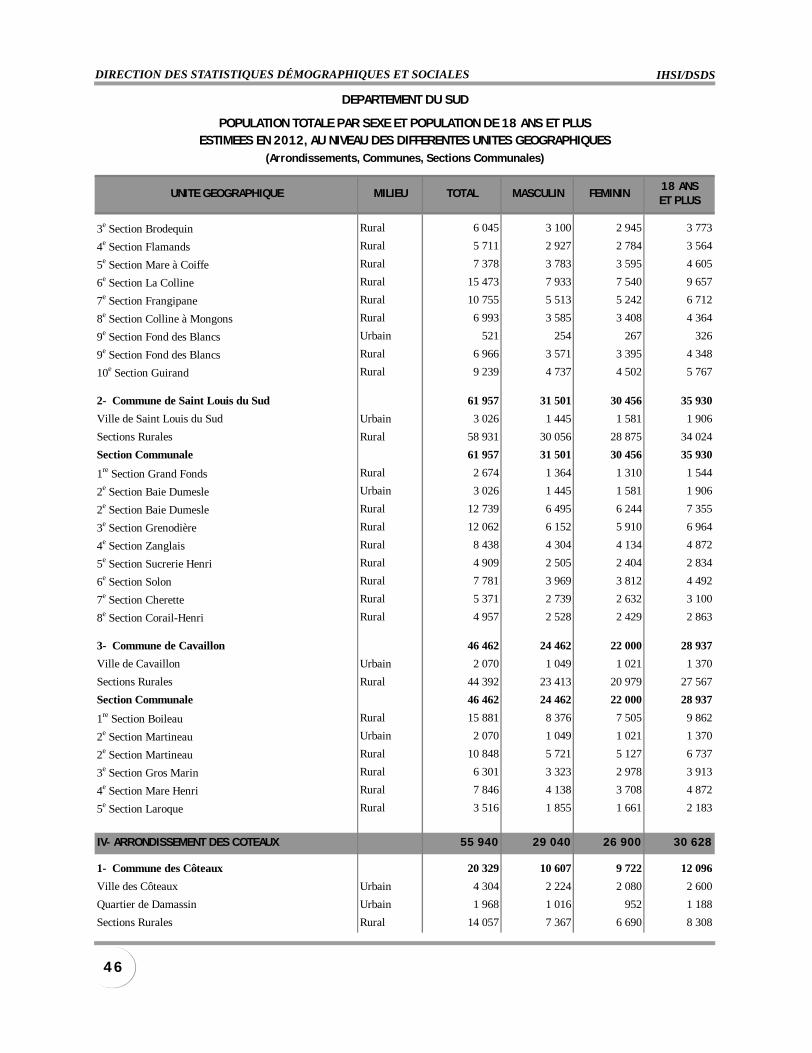
IHSI/DSDSDIRECTION DES STATISTIQUES DÉMOGRAPHIQUES ET SOCIALES
4 6
UNITE GEOGRAPHIQUE MILIEU TOTAL MASCULIN FEMININ18 ANSET PLUS
3e Section Brodequin Rural 6 045 3 100 2 945 3 773
4e Section Flamands Rural 5 711 2 927 2 784 3 564
5e Section Mare à Coiffe Rural 7 378 3 783 3 595 4 605
6e Section La Colline Rural 15 473 7 933 7 540 9 657
7e Section Frangipane Rural 10 755 5 513 5 242 6 712
8e Section Colline à Mongons Rural 6 993 3 585 3 408 4 364
9e Section Fond des Blancs Urbain 521 254 267 326
9e Section Fond des Blancs Rural 6 966 3 571 3 395 4 348
10e Section Guirand Rural 9 239 4 737 4 502 5 767
2- Commune de Saint Louis du Sud 61 957 31 501 30 456 35 930
Ville de Saint Louis du Sud Urbain 3 026 1 445 1 581 1 906
Sections Rurales Rural 58 931 30 056 28 875 34 024
Section Communale 61 957 31 501 30 456 35 930
1re Section Grand Fonds Rural 2 674 1 364 1 310 1 544
2e Section Baie Dumesle Urbain 3 026 1 445 1 581 1 906
2e Section Baie Dumesle Rural 12 739 6 495 6 244 7 355
3e Section Grenodière Rural 12 062 6 152 5 910 6 964
4e Section Zanglais Rural 8 438 4 304 4 134 4 872
5e Section Sucrerie Henri Rural 4 909 2 505 2 404 2 834
6e Section Solon Rural 7 781 3 969 3 812 4 492
7e Section Cherette Rural 5 371 2 739 2 632 3 100
8e Section Corail-Henri Rural 4 957 2 528 2 429 2 863
3- Commune de Cavaillon 46 462 24 462 22 000 28 937
Ville de Cavaillon Urbain 2 070 1 049 1 021 1 370
Sections Rurales Rural 44 392 23 413 20 979 27 567
Section Communale 46 462 24 462 22 000 28 937
1re Section Boileau Rural 15 881 8 376 7 505 9 862
2e Section Martineau Urbain 2 070 1 049 1 021 1 370
2e Section Martineau Rural 10 848 5 721 5 127 6 737
3e Section Gros Marin Rural 6 301 3 323 2 978 3 913
4e Section Mare Henri Rural 7 846 4 138 3 708 4 872
5e Section Laroque Rural 3 516 1 855 1 661 2 183
IV- ARRONDISSEMENT DES COTEAUX 55 940 29 040 26 900 30 628
1- Commune des Côteaux 20 329 10 607 9 722 12 096
Ville des Côteaux Urbain 4 304 2 224 2 080 2 600
Quartier de Damassin Urbain 1 968 1 016 952 1 188
Sections Rurales Rural 14 057 7 367 6 690 8 308
DEPARTEMENT DU SUD
POPULATION TOTALE PAR SEXE ET POPULATION DE 18 ANS ET PLUSESTIMEES EN 2012, AU NIVEAU DES DIFFERENTES UNITES GEOGRAPHIQUES
(Arrondissements, Communes, Sections Communales)
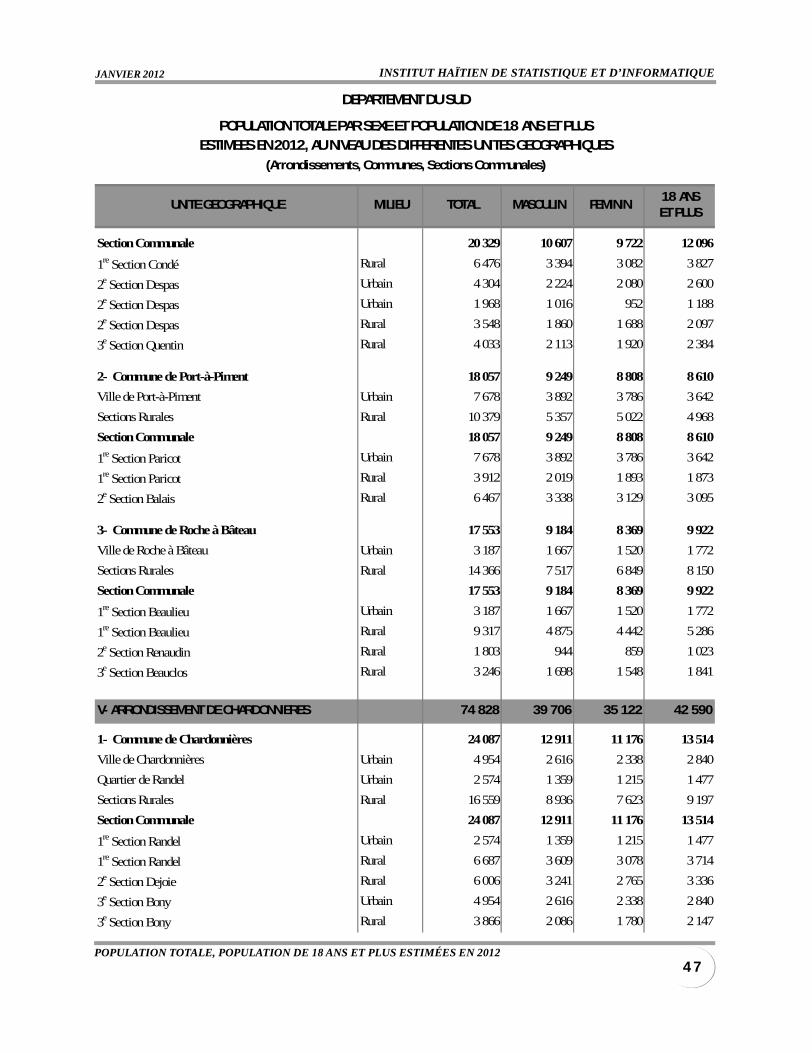
INSTITUT HAÏTIEN DE STATISTIQUE ET D’INFORMATIQUEJANVIER 2012
4 7POPULATION TOTALE, POPULATION DE 18 ANS ET PLUS ESTIMÉES EN 2012
UNITE GEOGRAPHIQUE MILIEU TOTAL MASCULIN FEMININ18 ANSET PLUS
Section Communale 20 329 10 607 9 722 12 096
1re Section Condé Rural 6 476 3 394 3 082 3 827
2e Section Despas Urbain 4 304 2 224 2 080 2 600
2e Section Despas Urbain 1 968 1 016 952 1 188
2e Section Despas Rural 3 548 1 860 1 688 2 097
3e Section Quentin Rural 4 033 2 113 1 920 2 384
2- Commune de Port-à-Piment 18 057 9 249 8 808 8 610
Ville de Port-à-Piment Urbain 7 678 3 892 3 786 3 642
Sections Rurales Rural 10 379 5 357 5 022 4 968
Section Communale 18 057 9 249 8 808 8 610
1re Section Paricot Urbain 7 678 3 892 3 786 3 642
1re Section Paricot Rural 3 912 2 019 1 893 1 873
2e Section Balais Rural 6 467 3 338 3 129 3 095
3- Commune de Roche à Bâteau 17 553 9 184 8 369 9 922
Ville de Roche à Bâteau Urbain 3 187 1 667 1 520 1 772
Sections Rurales Rural 14 366 7 517 6 849 8 150
Section Communale 17 553 9 184 8 369 9 922
1re Section Beaulieu Urbain 3 187 1 667 1 520 1 772
1re Section Beaulieu Rural 9 317 4 875 4 442 5 286
2e Section Renaudin Rural 1 803 944 859 1 023
3e Section Beauclos Rural 3 246 1 698 1 548 1 841
V- ARRONDISSEMENT DE CHARDONNIERES 74 828 39 706 35 122 42 590
1- Commune de Chardonnières 24 087 12 911 11 176 13 514
Ville de Chardonnières Urbain 4 954 2 616 2 338 2 840
Quartier de Randel Urbain 2 574 1 359 1 215 1 477
Sections Rurales Rural 16 559 8 936 7 623 9 197
Section Communale 24 087 12 911 11 176 13 514
1re Section Randel Urbain 2 574 1 359 1 215 1 477
1re Section Randel Rural 6 687 3 609 3 078 3 714
2e Section Dejoie Rural 6 006 3 241 2 765 3 336
3e Section Bony Urbain 4 954 2 616 2 338 2 840
3e Section Bony Rural 3 866 2 086 1 780 2 147
DEPARTEMENT DU SUD
POPULATION TOTALE PAR SEXE ET POPULATION DE 18 ANS ET PLUSESTIMEES EN 2012, AU NIVEAU DES DIFFERENTES UNITES GEOGRAPHIQUES
(Arrondissements, Communes, Sections Communales)
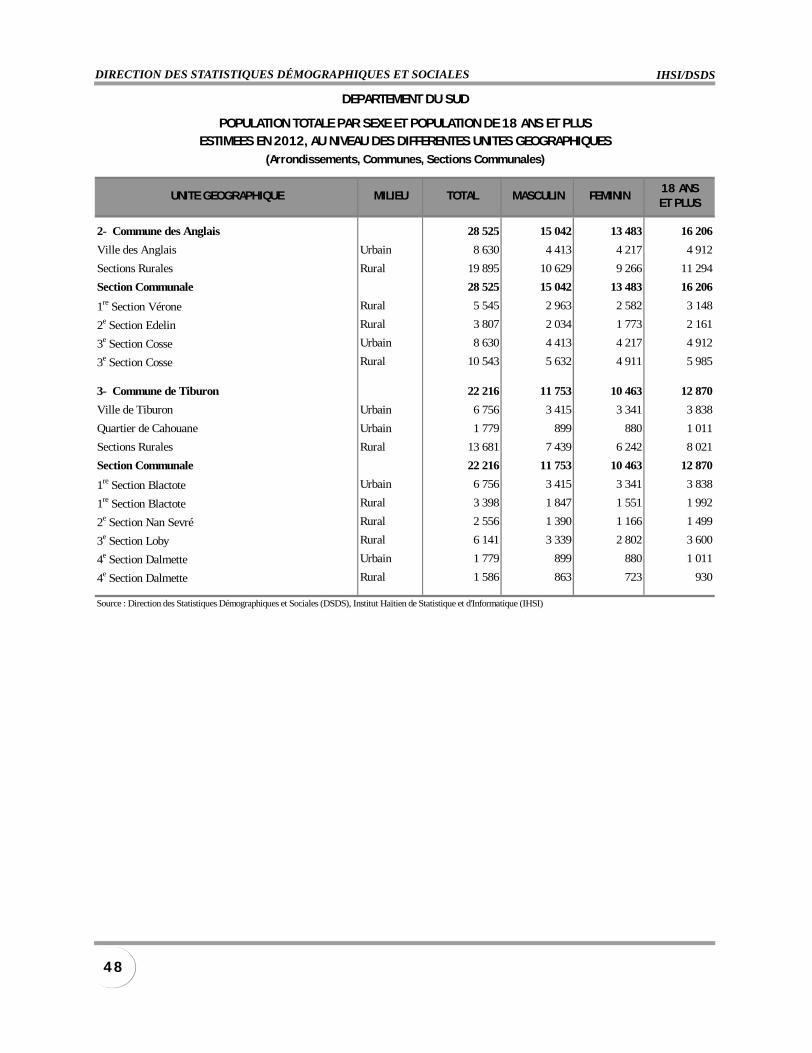
IHSI/DSDSDIRECTION DES STATISTIQUES DÉMOGRAPHIQUES ET SOCIALES
4 8
UNITE GEOGRAPHIQUE MILIEU TOTAL MASCULIN FEMININ18 ANSET PLUS
2- Commune des Anglais 28 525 15 042 13 483 16 206
Ville des Anglais Urbain 8 630 4 413 4 217 4 912
Sections Rurales Rural 19 895 10 629 9 266 11 294
Section Communale 28 525 15 042 13 483 16 206
1re Section Vérone Rural 5 545 2 963 2 582 3 148
2e Section Edelin Rural 3 807 2 034 1 773 2 161
3e Section Cosse Urbain 8 630 4 413 4 217 4 912
3e Section Cosse Rural 10 543 5 632 4 911 5 985
3- Commune de Tiburon 22 216 11 753 10 463 12 870
Ville de Tiburon Urbain 6 756 3 415 3 341 3 838
Quartier de Cahouane Urbain 1 779 899 880 1 011
Sections Rurales Rural 13 681 7 439 6 242 8 021
Section Communale 22 216 11 753 10 463 12 870
1re Section Blactote Urbain 6 756 3 415 3 341 3 838
1re Section Blactote Rural 3 398 1 847 1 551 1 992
2e Section Nan Sevré Rural 2 556 1 390 1 166 1 499
3e Section Loby Rural 6 141 3 339 2 802 3 600
4e Section Dalmette Urbain 1 779 899 880 1 011
4e Section Dalmette Rural 1 586 863 723 930
Source : Direction des Statistiques Démographiques et Sociales (DSDS), Institut Haïtien de Statistique et d'Informatique (IHSI)
DEPARTEMENT DU SUD
POPULATION TOTALE PAR SEXE ET POPULATION DE 18 ANS ET PLUSESTIMEES EN 2012, AU NIVEAU DES DIFFERENTES UNITES GEOGRAPHIQUES
(Arrondissements, Communes, Sections Communales)
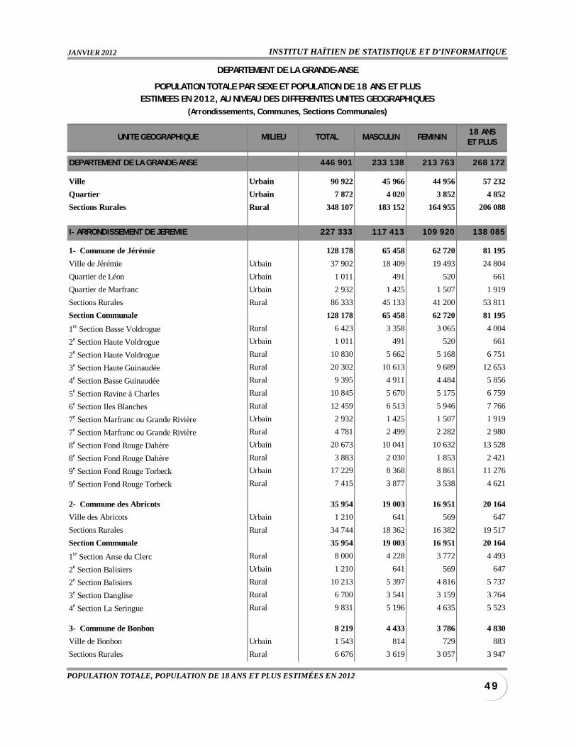
INSTITUT HAÏTIEN DE STATISTIQUE ET D’INFORMATIQUEJANVIER 2012
4 9POPULATION TOTALE, POPULATION DE 18 ANS ET PLUS ESTIMÉES EN 2012
UNITE GEOGRAPHIQUE MILIEU TOTAL MASCULIN FEMININ18 ANSET PLUS
DEPARTEMENT DE LA GRANDE-ANSE 446 901 233 138 213 763 268 172
Ville Urbain 90 922 45 966 44 956 57 232
Quartier Urbain 7 872 4 020 3 852 4 852
Sections Rurales Rural 348 107 183 152 164 955 206 088
I- ARRONDISSEMENT DE JEREMIE 227 333 117 413 109 920 138 085
1- Commune de Jérémie 128 178 65 458 62 720 81 195
Ville de Jérémie Urbain 37 902 18 409 19 493 24 804
Quartier de Léon Urbain 1 011 491 520 661
Quartier de Marfranc Urbain 2 932 1 425 1 507 1 919
Sections Rurales Rural 86 333 45 133 41 200 53 811
Section Communale 128 178 65 458 62 720 81 195
1re Section Basse Voldrogue Rural 6 423 3 358 3 065 4 004
2e Section Haute Voldrogue Urbain 1 011 491 520 661
2e Section Haute Voldrogue Rural 10 830 5 662 5 168 6 751
3e Section Haute Guinaudée Rural 20 302 10 613 9 689 12 653
4e Section Basse Guinaudée Rural 9 395 4 911 4 484 5 856
5e Section Ravine à Charles Rural 10 845 5 670 5 175 6 759
6e Section Iles Blanches Rural 12 459 6 513 5 946 7 766
7e Section Marfranc ou Grande Rivière Urbain 2 932 1 425 1 507 1 919
7e Section Marfranc ou Grande Rivière Rural 4 781 2 499 2 282 2 980
8e Section Fond Rouge Dahère Urbain 20 673 10 041 10 632 13 528
8e Section Fond Rouge Dahère Rural 3 883 2 030 1 853 2 421
9e Section Fond Rouge Torbeck Urbain 17 229 8 368 8 861 11 276
9e Section Fond Rouge Torbeck Rural 7 415 3 877 3 538 4 621
2- Commune des Abricots 35 954 19 003 16 951 20 164
Ville des Abricots Urbain 1 210 641 569 647
Sections Rurales Rural 34 744 18 362 16 382 19 517
Section Communale 35 954 19 003 16 951 20 164
1re Section Anse du Clerc Rural 8 000 4 228 3 772 4 493
2e Section Balisiers Urbain 1 210 641 569 647
2e Section Balisiers Rural 10 213 5 397 4 816 5 737
3e Section Danglise Rural 6 700 3 541 3 159 3 764
4e Section La Seringue Rural 9 831 5 196 4 635 5 523
3- Commune de Bonbon 8 219 4 433 3 786 4 830
Ville de Bonbon Urbain 1 543 814 729 883
Sections Rurales Rural 6 676 3 619 3 057 3 947
DEPARTEMENT DE LA GRANDE-ANSE
POPULATION TOTALE PAR SEXE ET POPULATION DE 18 ANS ET PLUSESTIMEES EN 2012, AU NIVEAU DES DIFFERENTES UNITES GEOGRAPHIQUES
(Arrondissements, Communes, Sections Communales)
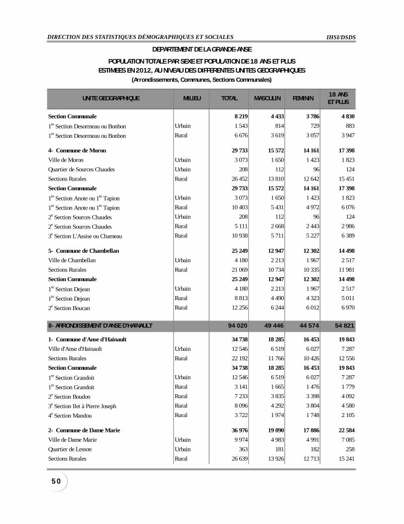
IHSI/DSDSDIRECTION DES STATISTIQUES DÉMOGRAPHIQUES ET SOCIALES
5 0
UNITE GEOGRAPHIQUE MILIEU TOTAL MASCULIN FEMININ18 ANSET PLUS
Section Communale 8 219 4 433 3 786 4 830
1re Section Desormeau ou Bonbon Urbain 1 543 814 729 883
1re Section Desormeau ou Bonbon Rural 6 676 3 619 3 057 3 947
4- Commune de Moron 29 733 15 572 14 161 17 398
Ville de Moron Urbain 3 073 1 650 1 423 1 823
Quartier de Sources Chaudes Urbain 208 112 96 124
Sections Rurales Rural 26 452 13 810 12 642 15 451
Section Communale 29 733 15 572 14 161 17 398
1re Section Anote ou 1re Tapion Urbain 3 073 1 650 1 423 1 823
1re Section Anote ou 1re Tapion Rural 10 403 5 431 4 972 6 076
2e Section Sources Chaudes Urbain 208 112 96 124
2e Section Sources Chaudes Rural 5 111 2 668 2 443 2 986
3e Section L'Assise ou Chameau Rural 10 938 5 711 5 227 6 389
5- Commune de Chambellan 25 249 12 947 12 302 14 498
Ville de Chambellan Urbain 4 180 2 213 1 967 2 517
Sections Rurales Rural 21 069 10 734 10 335 11 981
Section Communale 25 249 12 947 12 302 14 498
1re Section Dejean Urbain 4 180 2 213 1 967 2 517
1re Section Dejean Rural 8 813 4 490 4 323 5 011
2e Section Boucan Rural 12 256 6 244 6 012 6 970
II- ARRONDISSEMENT D'ANSE D'HAINAULT 94 020 49 446 44 574 54 821
1- Commune d'Anse d'Hainault 34 738 18 285 16 453 19 843
Ville d'Anse d'Hainault Urbain 12 546 6 519 6 027 7 287
Sections Rurales Rural 22 192 11 766 10 426 12 556
Section Communale 34 738 18 285 16 453 19 843
1re Section Grandoit Urbain 12 546 6 519 6 027 7 287
1re Section Grandoit Rural 3 141 1 665 1 476 1 779
2e Section Boudon Rural 7 233 3 835 3 398 4 092
3e Section Ilet à Pierre Joseph Rural 8 096 4 292 3 804 4 580
4e Section Mandou Rural 3 722 1 974 1 748 2 105
2- Commune de Dame Marie 36 976 19 090 17 886 22 584
Ville de Dame Marie Urbain 9 974 4 983 4 991 7 085
Quartier de Lesson Urbain 363 181 182 258
Sections Rurales Rural 26 639 13 926 12 713 15 241
DEPARTEMENT DE LA GRANDE-ANSE
POPULATION TOTALE PAR SEXE ET POPULATION DE 18 ANS ET PLUSESTIMEES EN 2012, AU NIVEAU DES DIFFERENTES UNITES GEOGRAPHIQUES
(Arrondissements, Communes, Sections Communales)
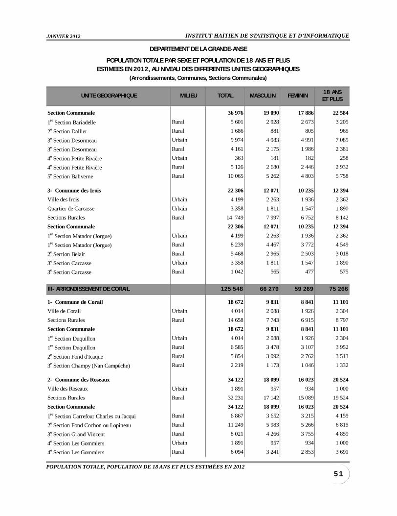
INSTITUT HAÏTIEN DE STATISTIQUE ET D’INFORMATIQUEJANVIER 2012
5 1POPULATION TOTALE, POPULATION DE 18 ANS ET PLUS ESTIMÉES EN 2012
UNITE GEOGRAPHIQUE MILIEU TOTAL MASCULIN FEMININ18 ANSET PLUS
Section Communale 36 976 19 090 17 886 22 584
1re Section Bariadelle Rural 5 601 2 928 2 673 3 205
2e Section Dallier Rural 1 686 881 805 965
3e Section Desormeau Urbain 9 974 4 983 4 991 7 085
3e Section Desormeau Rural 4 161 2 175 1 986 2 381
4e Section Petite Rivière Urbain 363 181 182 258
4e Section Petite Rivière Rural 5 126 2 680 2 446 2 932
5e Section Baliverne Rural 10 065 5 262 4 803 5 758
3- Commune des Irois 22 306 12 071 10 235 12 394
Ville des Irois Urbain 4 199 2 263 1 936 2 362
Quartier de Carcasse Urbain 3 358 1 811 1 547 1 890
Sections Rurales Rural 14 749 7 997 6 752 8 142
Section Communale 22 306 12 071 10 235 12 394
1re Section Matador (Jorgue) Urbain 4 199 2 263 1 936 2 362
1re Section Matador (Jorgue) Rural 8 239 4 467 3 772 4 549
2e Section Belair Rural 5 468 2 965 2 503 3 018
3e Section Carcasse Urbain 3 358 1 811 1 547 1 890
3e Section Carcasse Rural 1 042 565 477 575
III- ARRONDISSEMENT DE CORAIL 125 548 66 279 59 269 75 266
1- Commune de Corail 18 672 9 831 8 841 11 101
Ville de Corail Urbain 4 014 2 088 1 926 2 304
Sections Rurales Rural 14 658 7 743 6 915 8 797
Section Communale 18 672 9 831 8 841 11 101
1re Section Duquillon Urbain 4 014 2 088 1 926 2 304
1re Section Duquillon Rural 6 585 3 478 3 107 3 952
2e Section Fond d'Icaque Rural 5 854 3 092 2 762 3 513
3e Section Champy (Nan Campêche) Rural 2 219 1 173 1 046 1 332
2- Commune des Roseaux 34 122 18 099 16 023 20 524
Ville des Roseaux Urbain 1 891 957 934 1 000
Sections Rurales Rural 32 231 17 142 15 089 19 524
Section Communale 34 122 18 099 16 023 20 524
1re Section Carrefour Charles ou Jacqui Rural 6 867 3 652 3 215 4 159
2e Section Fond Cochon ou Lopineau Rural 11 249 5 983 5 266 6 815
3e Section Grand Vincent Rural 8 021 4 266 3 755 4 859
4e Section Les Gommiers Urbain 1 891 957 934 1 000
4e Section Les Gommiers Rural 6 094 3 241 2 853 3 691
DEPARTEMENT DE LA GRANDE-ANSE
POPULATION TOTALE PAR SEXE ET POPULATION DE 18 ANS ET PLUSESTIMEES EN 2012, AU NIVEAU DES DIFFERENTES UNITES GEOGRAPHIQUES
(Arrondissements, Communes, Sections Communales)
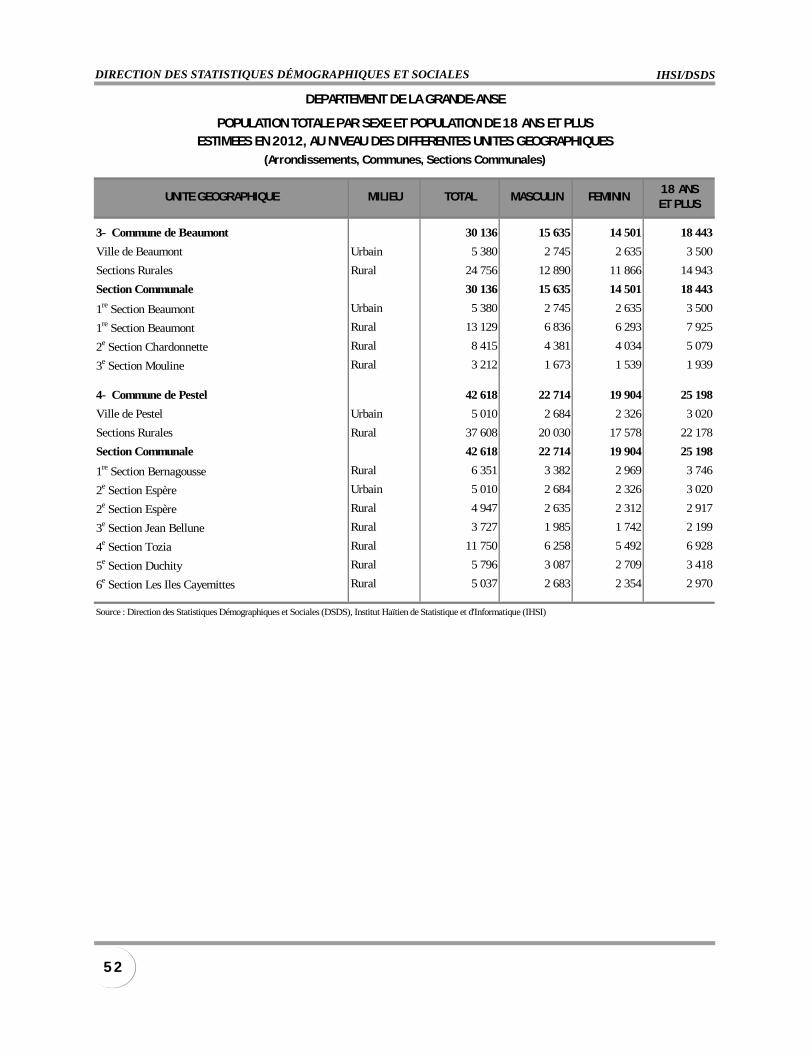
IHSI/DSDSDIRECTION DES STATISTIQUES DÉMOGRAPHIQUES ET SOCIALES
5 2
UNITE GEOGRAPHIQUE MILIEU TOTAL MASCULIN FEMININ18 ANSET PLUS
3- Commune de Beaumont 30 136 15 635 14 501 18 443
Ville de Beaumont Urbain 5 380 2 745 2 635 3 500
Sections Rurales Rural 24 756 12 890 11 866 14 943
Section Communale 30 136 15 635 14 501 18 443
1re Section Beaumont Urbain 5 380 2 745 2 635 3 500
1re Section Beaumont Rural 13 129 6 836 6 293 7 925
2e Section Chardonnette Rural 8 415 4 381 4 034 5 079
3e Section Mouline Rural 3 212 1 673 1 539 1 939
4- Commune de Pestel 42 618 22 714 19 904 25 198
Ville de Pestel Urbain 5 010 2 684 2 326 3 020
Sections Rurales Rural 37 608 20 030 17 578 22 178
Section Communale 42 618 22 714 19 904 25 198
1re Section Bernagousse Rural 6 351 3 382 2 969 3 746
2e Section Espère Urbain 5 010 2 684 2 326 3 020
2e Section Espère Rural 4 947 2 635 2 312 2 917
3e Section Jean Bellune Rural 3 727 1 985 1 742 2 199
4e Section Tozia Rural 11 750 6 258 5 492 6 928
5e Section Duchity Rural 5 796 3 087 2 709 3 418
6e Section Les Iles Cayemittes Rural 5 037 2 683 2 354 2 970
Source : Direction des Statistiques Démographiques et Sociales (DSDS), Institut Haïtien de Statistique et d'Informatique (IHSI)
DEPARTEMENT DE LA GRANDE-ANSE
POPULATION TOTALE PAR SEXE ET POPULATION DE 18 ANS ET PLUSESTIMEES EN 2012, AU NIVEAU DES DIFFERENTES UNITES GEOGRAPHIQUES
(Arrondissements, Communes, Sections Communales)
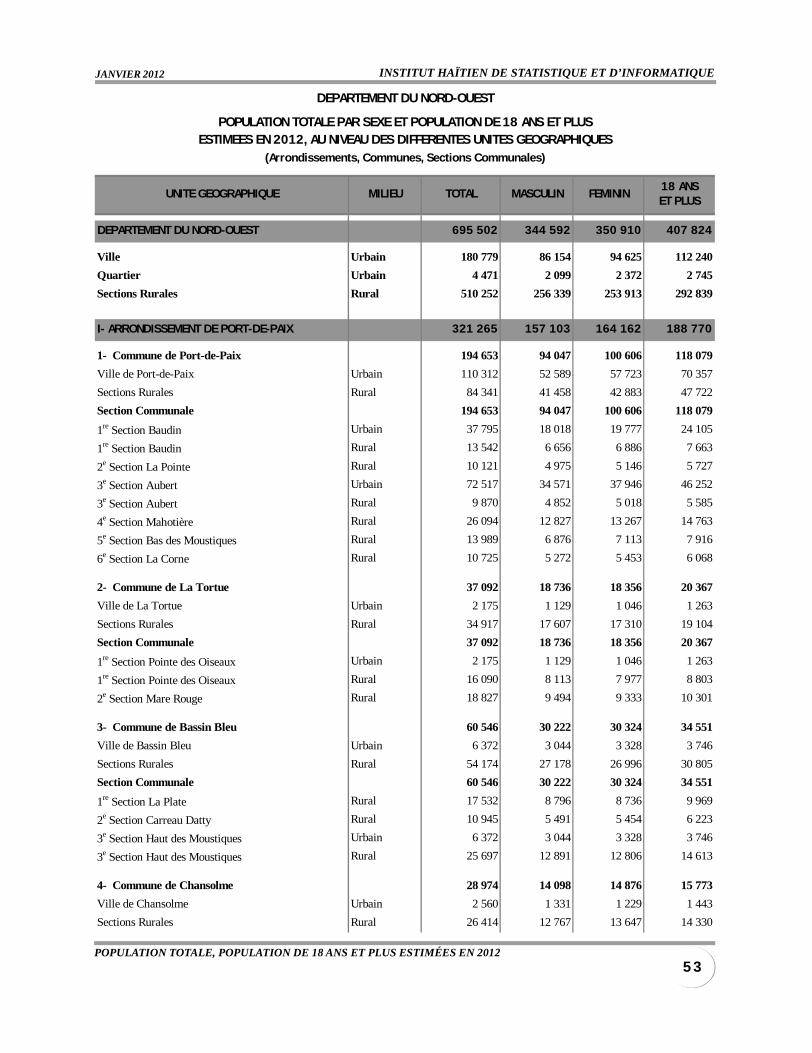
INSTITUT HAÏTIEN DE STATISTIQUE ET D’INFORMATIQUEJANVIER 2012
5 3POPULATION TOTALE, POPULATION DE 18 ANS ET PLUS ESTIMÉES EN 2012
UNITE GEOGRAPHIQUE MILIEU TOTAL MASCULIN FEMININ18 ANSET PLUS
DEPARTEMENT DU NORD-OUEST 695 502 344 592 350 910 407 824
Ville Urbain 180 779 86 154 94 625 112 240
Quartier Urbain 4 471 2 099 2 372 2 745
Sections Rurales Rural 510 252 256 339 253 913 292 839
I- ARRONDISSEMENT DE PORT-DE-PAIX 321 265 157 103 164 162 188 770
1- Commune de Port-de-Paix 194 653 94 047 100 606 118 079
Ville de Port-de-Paix Urbain 110 312 52 589 57 723 70 357
Sections Rurales Rural 84 341 41 458 42 883 47 722
Section Communale 194 653 94 047 100 606 118 079
1re Section Baudin Urbain 37 795 18 018 19 777 24 105
1re Section Baudin Rural 13 542 6 656 6 886 7 663
2e Section La Pointe Rural 10 121 4 975 5 146 5 727
3e Section Aubert Urbain 72 517 34 571 37 946 46 252
3e Section Aubert Rural 9 870 4 852 5 018 5 585
4e Section Mahotière Rural 26 094 12 827 13 267 14 763
5e Section Bas des Moustiques Rural 13 989 6 876 7 113 7 916
6e Section La Corne Rural 10 725 5 272 5 453 6 068
2- Commune de La Tortue 37 092 18 736 18 356 20 367
Ville de La Tortue Urbain 2 175 1 129 1 046 1 263
Sections Rurales Rural 34 917 17 607 17 310 19 104
Section Communale 37 092 18 736 18 356 20 367
1re Section Pointe des Oiseaux Urbain 2 175 1 129 1 046 1 263
1re Section Pointe des Oiseaux Rural 16 090 8 113 7 977 8 803
2e Section Mare Rouge Rural 18 827 9 494 9 333 10 301
3- Commune de Bassin Bleu 60 546 30 222 30 324 34 551
Ville de Bassin Bleu Urbain 6 372 3 044 3 328 3 746
Sections Rurales Rural 54 174 27 178 26 996 30 805
Section Communale 60 546 30 222 30 324 34 551
1re Section La Plate Rural 17 532 8 796 8 736 9 969
2e Section Carreau Datty Rural 10 945 5 491 5 454 6 223
3e Section Haut des Moustiques Urbain 6 372 3 044 3 328 3 746
3e Section Haut des Moustiques Rural 25 697 12 891 12 806 14 613
4- Commune de Chansolme 28 974 14 098 14 876 15 773
Ville de Chansolme Urbain 2 560 1 331 1 229 1 443
Sections Rurales Rural 26 414 12 767 13 647 14 330
DEPARTEMENT DU NORD-OUEST
POPULATION TOTALE PAR SEXE ET POPULATION DE 18 ANS ET PLUSESTIMEES EN 2012, AU NIVEAU DES DIFFERENTES UNITES GEOGRAPHIQUES
(Arrondissements, Communes, Sections Communales)
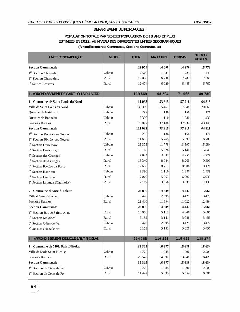
IHSI/DSDSDIRECTION DES STATISTIQUES DÉMOGRAPHIQUES ET SOCIALES
5 4
UNITE GEOGRAPHIQUE MILIEU TOTAL MASCULIN FEMININ18 ANSET PLUS
Section Communale 28 974 14 098 14 876 15 773
1re Section Chansolme Urbain 2 560 1 331 1 229 1 443
1re Section Chansolme Rural 13 940 6 738 7 202 7 563
2e Source Beauvoir Rural 12 474 6 029 6 445 6 767
II- ARRONDISSEMENT DE SAINT LOUIS DU NORD 139 869 68 204 71 665 80 780
1- Commune de Saint Louis du Nord 111 033 53 815 57 218 64 819
Ville de Saint Louis du Nord Urbain 33 309 15 461 17 848 20 063
Quartier de Guichard Urbain 292 136 156 176
Quartier de Bonneau Urbain 2 390 1 110 1 280 1 439
Sections Rurales Rural 75 042 37 108 37 934 43 141
Section Communale 111 033 53 815 57 218 64 819
1re Section Rivière des Nègres Urbain 292 136 156 176
1re Section Rivière des Nègres Rural 11 658 5 765 5 893 6 703
2e Section Derourvay Urbain 25 375 11 778 13 597 15 284
2e Section Derourvay Rural 10 168 5 028 5 140 5 845
3e Section des Granges Urbain 7 934 3 683 4 251 4 779
3e Section des Granges Rural 16 349 8 084 8 265 9 399
4e Section Rivière de Barre Rural 17 618 8 712 8 906 10 128
5e Section Bonneau Urbain 2 390 1 110 1 280 1 439
5e Section Bonneau Rural 12 060 5 963 6 097 6 933
6e Section Lafague (Chamoise) Rural 7 189 3 556 3 633 4 133
2- Commune d'Anse-à-Foleur 28 836 14 389 14 447 15 961
Ville d'Anse-à-Foleur Urbain 6 420 2 995 3 425 3 477
Sections Rurales Rural 22 416 11 394 11 022 12 484
Section Communale 28 836 14 389 14 447 15 961
1re Section Bas de Sainte Anne Rural 10 058 5 112 4 946 5 601
2e Section Mayance Rural 6 199 3 151 3 048 3 453
3e Section Côtes de Fer Urbain 6 420 2 995 3 425 3 477
3e Section Côtes de Fer Rural 6 159 3 131 3 028 3 430
III- ARRONDISSEMENT DE MÔLE SAINT NICOLAS 234 368 119 285 115 083 138 274
1- Commune de Môle Saint Nicolas 32 315 16 677 15 638 18 634
Ville de Môle Saint Nicolas Urbain 3 775 1 985 1 790 2 209
Sections Rurales Rural 28 540 14 692 13 848 16 425
Section Communale 32 315 16 677 15 638 18 634
1re Section de Côtes de Fer Urbain 3 775 1 985 1 790 2 209
1re Section de Côtes de Fer Rural 11 447 5 893 5 554 6 588
DEPARTEMENT DU NORD-OUEST
POPULATION TOTALE PAR SEXE ET POPULATION DE 18 ANS ET PLUSESTIMEES EN 2012, AU NIVEAU DES DIFFERENTES UNITES GEOGRAPHIQUES
(Arrondissements, Communes, Sections Communales)
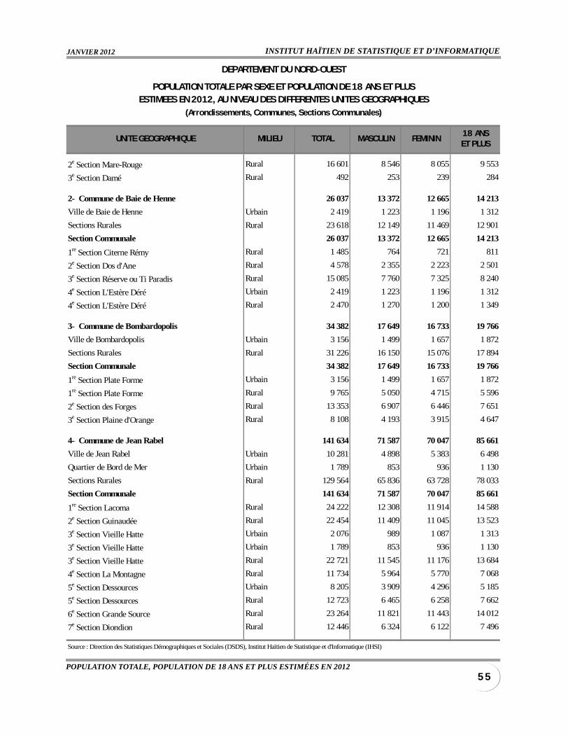
INSTITUT HAÏTIEN DE STATISTIQUE ET D’INFORMATIQUEJANVIER 2012
5 5POPULATION TOTALE, POPULATION DE 18 ANS ET PLUS ESTIMÉES EN 2012
UNITE GEOGRAPHIQUE MILIEU TOTAL MASCULIN FEMININ18 ANSET PLUS
2e Section Mare-Rouge Rural 16 601 8 546 8 055 9 553
3e Section Damé Rural 492 253 239 284
2- Commune de Baie de Henne 26 037 13 372 12 665 14 213
Ville de Baie de Henne Urbain 2 419 1 223 1 196 1 312
Sections Rurales Rural 23 618 12 149 11 469 12 901
Section Communale 26 037 13 372 12 665 14 213
1re Section Citerne Rémy Rural 1 485 764 721 811
2e Section Dos d'Ane Rural 4 578 2 355 2 223 2 501
3e Section Réserve ou Ti Paradis Rural 15 085 7 760 7 325 8 240
4e Section L'Estère Déré Urbain 2 419 1 223 1 196 1 312
4e Section L'Estère Déré Rural 2 470 1 270 1 200 1 349
3- Commune de Bombardopolis 34 382 17 649 16 733 19 766
Ville de Bombardopolis Urbain 3 156 1 499 1 657 1 872
Sections Rurales Rural 31 226 16 150 15 076 17 894
Section Communale 34 382 17 649 16 733 19 766
1re Section Plate Forme Urbain 3 156 1 499 1 657 1 872
1re Section Plate Forme Rural 9 765 5 050 4 715 5 596
2e Section des Forges Rural 13 353 6 907 6 446 7 651
3e Section Plaine d'Orange Rural 8 108 4 193 3 915 4 647
4- Commune de Jean Rabel 141 634 71 587 70 047 85 661
Ville de Jean Rabel Urbain 10 281 4 898 5 383 6 498
Quartier de Bord de Mer Urbain 1 789 853 936 1 130
Sections Rurales Rural 129 564 65 836 63 728 78 033
Section Communale 141 634 71 587 70 047 85 661
1re Section Lacoma Rural 24 222 12 308 11 914 14 588
2e Section Guinaudée Rural 22 454 11 409 11 045 13 523
3e Section Vieille Hatte Urbain 2 076 989 1 087 1 313
3e Section Vieille Hatte Urbain 1 789 853 936 1 130
3e Section Vieille Hatte Rural 22 721 11 545 11 176 13 684
4e Section La Montagne Rural 11 734 5 964 5 770 7 068
5e Section Dessources Urbain 8 205 3 909 4 296 5 185
5e Section Dessources Rural 12 723 6 465 6 258 7 662
6e Section Grande Source Rural 23 264 11 821 11 443 14 012
7e Section Diondion Rural 12 446 6 324 6 122 7 496
Source : Direction des Statistiques Démographiques et Sociales (DSDS), Institut Haïtien de Statistique et d'Informatique (IHSI)
DEPARTEMENT DU NORD-OUEST
POPULATION TOTALE PAR SEXE ET POPULATION DE 18 ANS ET PLUSESTIMEES EN 2012, AU NIVEAU DES DIFFERENTES UNITES GEOGRAPHIQUES
(Arrondissements, Communes, Sections Communales)
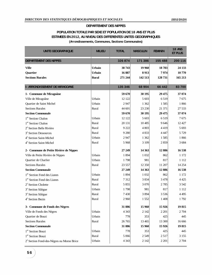
IHSI/DSDSDIRECTION DES STATISTIQUES DÉMOGRAPHIQUES ET SOCIALES
5 6
UNITE GEOGRAPHIQUE MILIEU TOTAL MASCULIN FEMININ18 ANSET PLUS
DEPARTEMENT DES NIPPES 326 874 171 386 155 488 200 116
Ville Urbain 38 743 19 960 18 783 24 133
Quartier Urbain 16 887 8 913 7 974 10 770
Sections Rurales Rural 271 244 142 513 128 731 165 213
I- ARRONDISSEMENT DE MIRAGOANE 135 346 68 904 66 442 83 700
1- Commune de Miragoâne 59 670 30 195 29 475 37 074
Ville de Miragoâne Urbain 12 122 5 603 6 519 7 675
Quartier de Saint Michel Urbain 2 947 1 362 1 585 1 866
Sections Rurales Rural 44 601 23 230 21 371 27 533
Section Communale 59 670 30 195 29 475 37 074
1re Section Chalon Urbain 12 122 5 603 6 519 7 675
1re Section Chalon Rural 20 131 10 485 9 646 12 427
2e Section Belle Rivière Rural 9 222 4 803 4 419 5 693
3e Section Dessources Rural 9 280 4 833 4 447 5 729
4e Section Saint-Michel Urbain 2 947 1 362 1 585 1 866
4e Section Saint-Michel Rural 5 968 3 109 2 859 3 684
2- Commune de Petite Rivière de Nippes 27 249 14 363 12 886 16 538
Ville de Petite Rivière de Nippes Urbain 1 894 1 032 862 1 172
Quartier de Charlier Urbain 1 798 981 817 1 112
Sections Rurales Rural 23 557 12 350 11 207 14 254
Section Communale 27 249 14 363 12 886 16 538
1re Section Fond des Lianes Urbain 1 894 1 032 862 1 172
1re Section Fond des Lianes Rural 7 312 3 834 3 478 4 425
2e Section Cholette Rural 5 855 3 070 2 785 3 542
3e Section Silègue Urbain 1 798 981 817 1 112
3e Section Silègue Rural 7 430 3 894 3 536 4 495
4e Section Bezin Rural 2 960 1 552 1 408 1 792
3- Commune de Fonds des Nègres 31 886 15 960 15 926 19 815
Ville de Fonds des Nègres Urbain 4 343 2 142 2 201 2 704
Quartier de Bouzi Urbain 778 353 425 445
Sections Rurales Rural 26 765 13 465 13 300 16 666
Section Communale 31 886 15 960 15 926 19 815
1re Section Bouzi Urbain 778 353 425 445
1re Section Bouzi Rural 5 066 2 549 2 517 3 155
2e Section Fond-des-Nègres ou Morne Brice Urbain 4 343 2 142 2 201 2 704
DEPARTEMENT DES NIPPES
POPULATION TOTALE PAR SEXE ET POPULATION DE 18 ANS ET PLUSESTIMEES EN 2012, AU NIVEAU DES DIFFERENTES UNITES GEOGRAPHIQUES
(Arrondissements, Communes, Sections Communales)
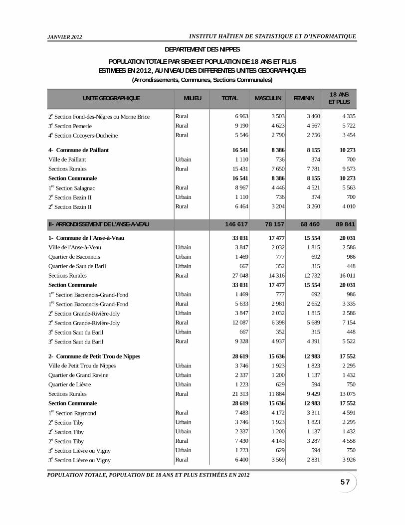
INSTITUT HAÏTIEN DE STATISTIQUE ET D’INFORMATIQUEJANVIER 2012
5 7POPULATION TOTALE, POPULATION DE 18 ANS ET PLUS ESTIMÉES EN 2012
UNITE GEOGRAPHIQUE MILIEU TOTAL MASCULIN FEMININ18 ANSET PLUS
2e Section Fond-des-Nègres ou Morne Brice Rural 6 963 3 503 3 460 4 335
3e Section Pemerle Rural 9 190 4 623 4 567 5 722
4e Section Cocoyers-Ducheine Rural 5 546 2 790 2 756 3 454
4- Commune de Paillant 16 541 8 386 8 155 10 273
Ville de Paillant Urbain 1 110 736 374 700
Sections Rurales Rural 15 431 7 650 7 781 9 573
Section Communale 16 541 8 386 8 155 10 273
1re Section Salagnac Rural 8 967 4 446 4 521 5 563
2e Section Bezin II Urbain 1 110 736 374 700
2e Section Bezin II Rural 6 464 3 204 3 260 4 010
II- ARRONDISSEMENT DE L'ANSE-A-VEAU 146 617 78 157 68 460 89 841
1- Commune de l'Anse-à-Veau 33 031 17 477 15 554 20 031
Ville de l'Anse-à-Veau Urbain 3 847 2 032 1 815 2 586
Quartier de Baconnois Urbain 1 469 777 692 986
Quartier de Saut de Baril Urbain 667 352 315 448
Sections Rurales Rural 27 048 14 316 12 732 16 011
Section Communale 33 031 17 477 15 554 20 031
1re Section Baconnois-Grand-Fond Urbain 1 469 777 692 986
1re Section Baconnois-Grand-Fond Rural 5 633 2 981 2 652 3 335
2e Section Grande-Rivière-Joly Urbain 3 847 2 032 1 815 2 586
2e Section Grande-Rivière-Joly Rural 12 087 6 398 5 689 7 154
3e Section Saut du Baril Urbain 667 352 315 448
3e Section Saut du Baril Rural 9 328 4 937 4 391 5 522
2- Commune de Petit Trou de Nippes 28 619 15 636 12 983 17 552
Ville de Petit Trou de Nippes Urbain 3 746 1 923 1 823 2 295
Quartier de Grand Ravine Urbain 2 337 1 200 1 137 1 432
Quartier de Lièvre Urbain 1 223 629 594 750
Sections Rurales Rural 21 313 11 884 9 429 13 075
Section Communale 28 619 15 636 12 983 17 552
1re Section Raymond Rural 7 483 4 172 3 311 4 591
2e Section Tiby Urbain 3 746 1 923 1 823 2 295
2e Section Tiby Urbain 2 337 1 200 1 137 1 432
2e Section Tiby Rural 7 430 4 143 3 287 4 558
3e Section Lièvre ou Vigny Urbain 1 223 629 594 750
3e Section Lièvre ou Vigny Rural 6 400 3 569 2 831 3 926
DEPARTEMENT DES NIPPES
POPULATION TOTALE PAR SEXE ET POPULATION DE 18 ANS ET PLUSESTIMEES EN 2012, AU NIVEAU DES DIFFERENTES UNITES GEOGRAPHIQUES
(Arrondissements, Communes, Sections Communales)
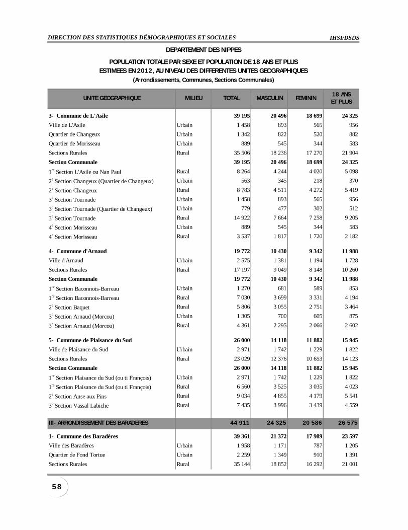
IHSI/DSDSDIRECTION DES STATISTIQUES DÉMOGRAPHIQUES ET SOCIALES
5 8
UNITE GEOGRAPHIQUE MILIEU TOTAL MASCULIN FEMININ18 ANSET PLUS
3- Commune de L'Asile 39 195 20 496 18 699 24 325
Ville de L'Asile Urbain 1 458 893 565 956
Quartier de Changeux Urbain 1 342 822 520 882
Quartier de Morisseau Urbain 889 545 344 583
Sections Rurales Rural 35 506 18 236 17 270 21 904
Section Communale 39 195 20 496 18 699 24 325
1re Section L'Asile ou Nan Paul Rural 8 264 4 244 4 020 5 098
2e Section Changeux (Quartier de Changeux) Urbain 563 345 218 370
2e Section Changeux Rural 8 783 4 511 4 272 5 419
3e Section Tournade Urbain 1 458 893 565 956
3e Section Tournade (Quartier de Changeux) Urbain 779 477 302 512
3e Section Tournade Rural 14 922 7 664 7 258 9 205
4e Section Morisseau Urbain 889 545 344 583
4e Section Morisseau Rural 3 537 1 817 1 720 2 182
4- Commune d'Arnaud 19 772 10 430 9 342 11 988
Ville d'Arnaud Urbain 2 575 1 381 1 194 1 728
Sections Rurales Rural 17 197 9 049 8 148 10 260
Section Communale 19 772 10 430 9 342 11 988
1re Section Baconnois-Barreau Urbain 1 270 681 589 853
1re Section Baconnois-Barreau Rural 7 030 3 699 3 331 4 194
2e Section Baquet Rural 5 806 3 055 2 751 3 464
3e Section Arnaud (Morcou) Urbain 1 305 700 605 875
3e Section Arnaud (Morcou) Rural 4 361 2 295 2 066 2 602
5- Commune de Plaisance du Sud 26 000 14 118 11 882 15 945
Ville de Plaisance du Sud Urbain 2 971 1 742 1 229 1 822
Sections Rurales Rural 23 029 12 376 10 653 14 123
Section Communale 26 000 14 118 11 882 15 945
1re Section Plaisance du Sud (ou ti François) Urbain 2 971 1 742 1 229 1 822
1re Section Plaisance du Sud (ou ti François) Rural 6 560 3 525 3 035 4 023
2e Section Anse aux Pins Rural 9 034 4 855 4 179 5 541
3e Section Vassal Labiche Rural 7 435 3 996 3 439 4 559
III- ARRONDISSEMENT DES BARADERES 44 911 24 325 20 586 26 575
1- Commune des Baradères 39 361 21 372 17 989 23 597
Ville des Baradères Urbain 1 958 1 171 787 1 205
Quartier de Fond Tortue Urbain 2 259 1 349 910 1 391
Sections Rurales Rural 35 144 18 852 16 292 21 001
DEPARTEMENT DES NIPPES
POPULATION TOTALE PAR SEXE ET POPULATION DE 18 ANS ET PLUSESTIMEES EN 2012, AU NIVEAU DES DIFFERENTES UNITES GEOGRAPHIQUES
(Arrondissements, Communes, Sections Communales)
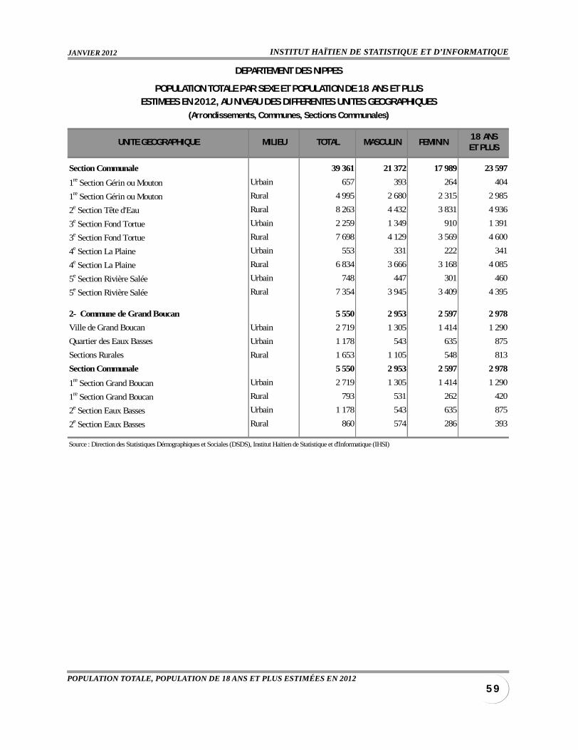
INSTITUT HAÏTIEN DE STATISTIQUE ET D’INFORMATIQUEJANVIER 2012
5 9POPULATION TOTALE, POPULATION DE 18 ANS ET PLUS ESTIMÉES EN 2012
UNITE GEOGRAPHIQUE MILIEU TOTAL MASCULIN FEMININ18 ANSET PLUS
Section Communale 39 361 21 372 17 989 23 597
1re Section Gérin ou Mouton Urbain 657 393 264 404
1re Section Gérin ou Mouton Rural 4 995 2 680 2 315 2 985
2e Section Tête d'Eau Rural 8 263 4 432 3 831 4 936
3e Section Fond Tortue Urbain 2 259 1 349 910 1 391
3e Section Fond Tortue Rural 7 698 4 129 3 569 4 600
4e Section La Plaine Urbain 553 331 222 341
4e Section La Plaine Rural 6 834 3 666 3 168 4 085
5e Section Rivière Salée Urbain 748 447 301 460
5e Section Rivière Salée Rural 7 354 3 945 3 409 4 395
2- Commune de Grand Boucan 5 550 2 953 2 597 2 978
Ville de Grand Boucan Urbain 2 719 1 305 1 414 1 290
Quartier des Eaux Basses Urbain 1 178 543 635 875
Sections Rurales Rural 1 653 1 105 548 813
Section Communale 5 550 2 953 2 597 2 978
1re Section Grand Boucan Urbain 2 719 1 305 1 414 1 290
1re Section Grand Boucan Rural 793 531 262 420
2e Section Eaux Basses Urbain 1 178 543 635 875
2e Section Eaux Basses Rural 860 574 286 393
Source : Direction des Statistiques Démographiques et Sociales (DSDS), Institut Haïtien de Statistique et d'Informatique (IHSI)
DEPARTEMENT DES NIPPES
POPULATION TOTALE PAR SEXE ET POPULATION DE 18 ANS ET PLUSESTIMEES EN 2012, AU NIVEAU DES DIFFERENTES UNITES GEOGRAPHIQUES
(Arrondissements, Communes, Sections Communales)

INSTITUT HAÏTIEN DE STATISTIQUE ET D’INFORMATIQUEJANVIER 2012
6 1MÉNAGES, SUPERFICIE ET DENSITÉ ESTIMÉS EN 2012
MÉNAGES, SUPERFICIE ET DENSITÉDES DIFFÉRENTES UNITÉS GÉOGRAPHIQUES
(DÉPARTEMENT, ARRONDISSEMENT, COMMUNE,VILLE, QUARTIER, SECTION COMMUNALE)

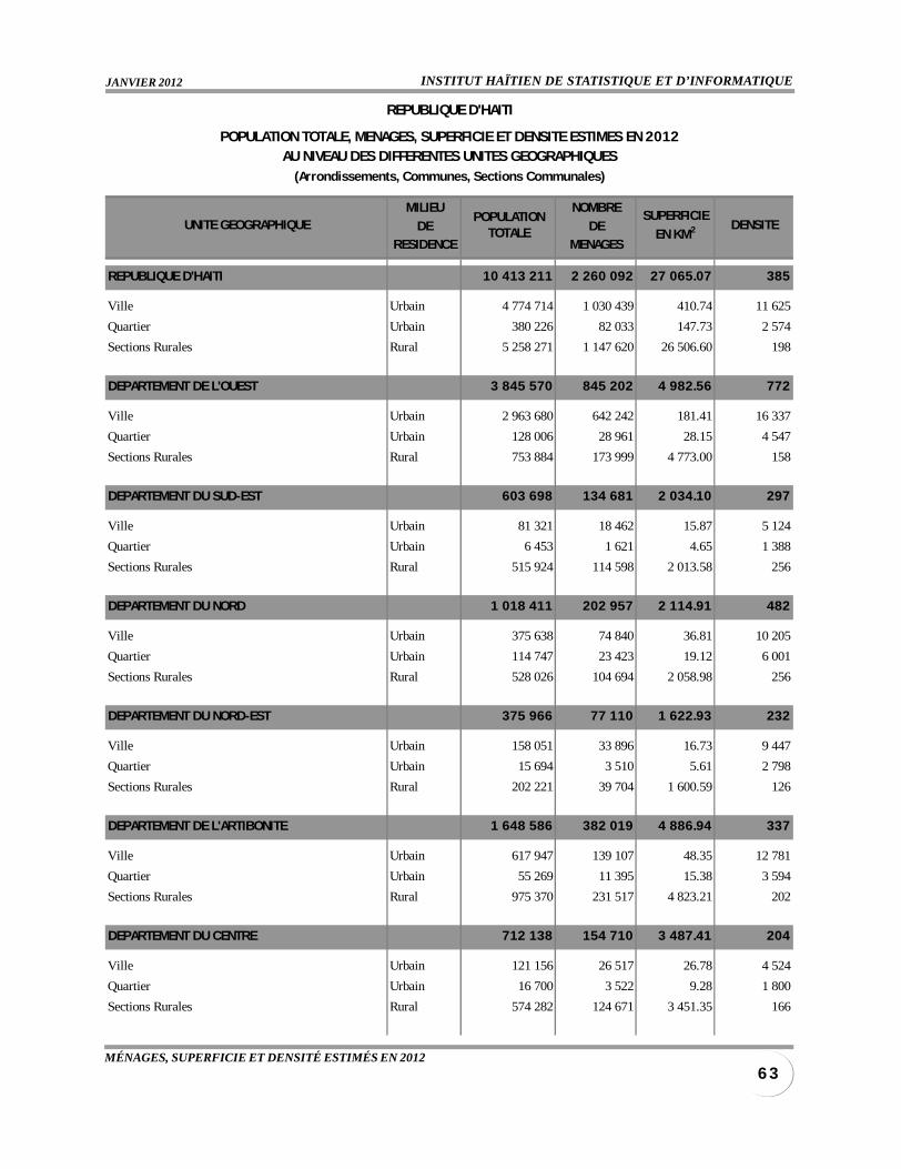
INSTITUT HAÏTIEN DE STATISTIQUE ET D’INFORMATIQUEJANVIER 2012
6 3MÉNAGES, SUPERFICIE ET DENSITÉ ESTIMÉS EN 2012
MILIEU NOMBRE
DE DERESIDENCE MENAGES
REPUBLIQUE D'HAITI 10 413 211 2 260 092 27 065.07 385
Ville Urbain 4 774 714 1 030 439 410.74 11 625
Quartier Urbain 380 226 82 033 147.73 2 574
Sections Rurales Rural 5 258 271 1 147 620 26 506.60 198
DEPARTEMENT DE L'OUEST 3 845 570 845 202 4 982.56 772
Ville Urbain 2 963 680 642 242 181.41 16 337
Quartier Urbain 128 006 28 961 28.15 4 547
Sections Rurales Rural 753 884 173 999 4 773.00 158
DEPARTEMENT DU SUD-EST 603 698 134 681 2 034.10 297
Ville Urbain 81 321 18 462 15.87 5 124
Quartier Urbain 6 453 1 621 4.65 1 388
Sections Rurales Rural 515 924 114 598 2 013.58 256
DEPARTEMENT DU NORD 1 018 411 202 957 2 114.91 482
Ville Urbain 375 638 74 840 36.81 10 205
Quartier Urbain 114 747 23 423 19.12 6 001
Sections Rurales Rural 528 026 104 694 2 058.98 256
DEPARTEMENT DU NORD-EST 375 966 77 110 1 622.93 232
Ville Urbain 158 051 33 896 16.73 9 447
Quartier Urbain 15 694 3 510 5.61 2 798
Sections Rurales Rural 202 221 39 704 1 600.59 126
DEPARTEMENT DE L'ARTIBONITE 1 648 586 382 019 4 886.94 337
Ville Urbain 617 947 139 107 48.35 12 781
Quartier Urbain 55 269 11 395 15.38 3 594
Sections Rurales Rural 975 370 231 517 4 823.21 202
DEPARTEMENT DU CENTRE 712 138 154 710 3 487.41 204
Ville Urbain 121 156 26 517 26.78 4 524
Quartier Urbain 16 700 3 522 9.28 1 800
Sections Rurales Rural 574 282 124 671 3 451.35 166
POPULATIONTOTALE
SUPERFICIE
EN KM2
REPUBLIQUE D'HAITI
POPULATION TOTALE, MENAGES, SUPERFICIE ET DENSITE ESTIMES EN 2012AU NIVEAU DES DIFFERENTES UNITES GEOGRAPHIQUES
(Arrondissements, Communes, Sections Communales)
UNITE GEOGRAPHIQUE DENSITE
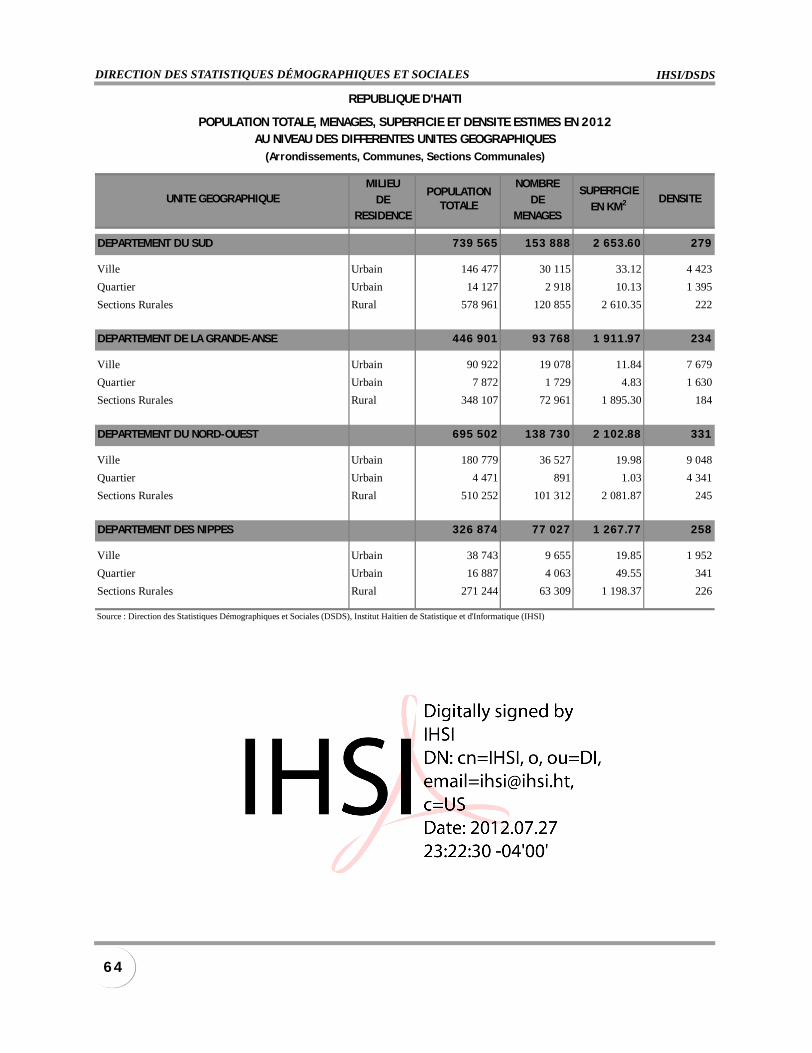
IHSI/DSDSDIRECTION DES STATISTIQUES DÉMOGRAPHIQUES ET SOCIALES
6 4
MILIEU NOMBRE
DE DERESIDENCE MENAGES
DEPARTEMENT DU SUD 739 565 153 888 2 653.60 279
Ville Urbain 146 477 30 115 33.12 4 423
Quartier Urbain 14 127 2 918 10.13 1 395
Sections Rurales Rural 578 961 120 855 2 610.35 222
DEPARTEMENT DE LA GRANDE-ANSE 446 901 93 768 1 911.97 234
Ville Urbain 90 922 19 078 11.84 7 679
Quartier Urbain 7 872 1 729 4.83 1 630
Sections Rurales Rural 348 107 72 961 1 895.30 184
DEPARTEMENT DU NORD-OUEST 695 502 138 730 2 102.88 331
Ville Urbain 180 779 36 527 19.98 9 048
Quartier Urbain 4 471 891 1.03 4 341
Sections Rurales Rural 510 252 101 312 2 081.87 245
DEPARTEMENT DES NIPPES 326 874 77 027 1 267.77 258
Ville Urbain 38 743 9 655 19.85 1 952
Quartier Urbain 16 887 4 063 49.55 341
Sections Rurales Rural 271 244 63 309 1 198.37 226
Source : Direction des Statistiques Démographiques et Sociales (DSDS), Institut Haïtien de Statistique et d'Informatique (IHSI)
POPULATIONTOTALE
SUPERFICIE
EN KM2
REPUBLIQUE D'HAITI
POPULATION TOTALE, MENAGES, SUPERFICIE ET DENSITE ESTIMES EN 2012AU NIVEAU DES DIFFERENTES UNITES GEOGRAPHIQUES
(Arrondissements, Communes, Sections Communales)
UNITE GEOGRAPHIQUE DENSITE
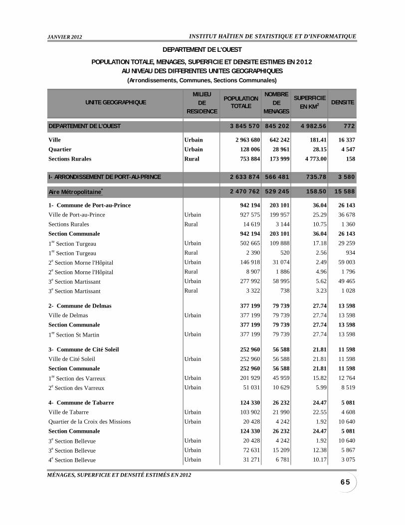
INSTITUT HAÏTIEN DE STATISTIQUE ET D’INFORMATIQUEJANVIER 2012
6 5MÉNAGES, SUPERFICIE ET DENSITÉ ESTIMÉS EN 2012
MILIEU NOMBRE
DE DERESIDENCE MENAGES
DEPARTEMENT DE L'OUEST 3 845 570 845 202 4 982.56 772
Ville Urbain 2 963 680 642 242 181.41 16 337
Quartier Urbain 128 006 28 961 28.15 4 547
Sections Rurales Rural 753 884 173 999 4 773.00 158
I- ARRONDISSEMENT DE PORT-AU-PRINCE 2 633 874 566 481 735.78 3 580
Aire Métropolitaine* 2 470 762 529 245 158.50 15 588
1- Commune de Port-au-Prince 942 194 203 101 36.04 26 143
Ville de Port-au-Prince Urbain 927 575 199 957 25.29 36 678
Sections Rurales Rural 14 619 3 144 10.75 1 360
Section Communale 942 194 203 101 36.04 26 143
1re Section Turgeau Urbain 502 665 109 888 17.18 29 259
1re Section Turgeau Rural 2 390 520 2.56 934
2e Section Morne l'Hôpital Urbain 146 918 31 074 2.49 59 003
2e Section Morne l'Hôpital Rural 8 907 1 886 4.96 1 796
3e Section Martissant Urbain 277 992 58 995 5.62 49 465
3e Section Martissant Rural 3 322 738 3.23 1 028
2- Commune de Delmas 377 199 79 739 27.74 13 598
Ville de Delmas Urbain 377 199 79 739 27.74 13 598
Section Communale 377 199 79 739 27.74 13 598
1re Section St Martin Urbain 377 199 79 739 27.74 13 598
3- Commune de Cité Soleil 252 960 56 588 21.81 11 598
Ville de Cité Soleil Urbain 252 960 56 588 21.81 11 598
Section Communale 252 960 56 588 21.81 11 598
1re Section des Varreux Urbain 201 929 45 959 15.82 12 764
2e Section des Varreux Urbain 51 031 10 629 5.99 8 519
4- Commune de Tabarre 124 330 26 232 24.47 5 081
Ville de Tabarre Urbain 103 902 21 990 22.55 4 608
Quartier de la Croix des Missions Urbain 20 428 4 242 1.92 10 640
Section Communale 124 330 26 232 24.47 5 081
3e Section Bellevue Urbain 20 428 4 242 1.92 10 640
3e Section Bellevue Urbain 72 631 15 209 12.38 5 867
4e Section Bellevue Urbain 31 271 6 781 10.17 3 075
POPULATIONTOTALE
SUPERFICIE
EN KM2 DENSITE
DEPARTEMENT DE L'OUEST
POPULATION TOTALE, MENAGES, SUPERFICIE ET DENSITE ESTIMES EN 2012AU NIVEAU DES DIFFERENTES UNITES GEOGRAPHIQUES
(Arrondissements, Communes, Sections Communales)
UNITE GEOGRAPHIQUE
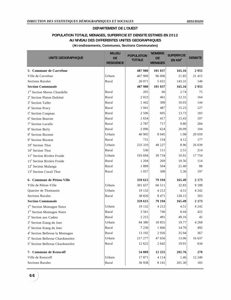
IHSI/DSDSDIRECTION DES STATISTIQUES DÉMOGRAPHIQUES ET SOCIALES
6 6
MILIEU NOMBRE
DE DERESIDENCE MENAGES
5- Commune de Carrefour 487 980 101 037 165.16 2 955
Ville de Carrefour Urbain 467 909 96 006 21.85 21 415
Sections Rurales Rural 20 071 5 031 143.31 140
Section Communale 487 980 101 037 165.16 2 955
1re Section Morne Chandelle Rural 205 66 2.74 75
2e Section Platon Dufréné Rural 2 023 461 12.31 164
3e Section Taïfer Rural 1 442 308 10.03 144
4e Section Procy Rural 1 941 487 15.23 127
5e Section Coupeau Rural 2 506 605 13.73 183
6e Section Bouvier Rural 1 654 417 15.43 107
7e Section Lavalle Rural 2 787 717 9.80 284
8e Section Berly Rural 2 096 624 20.09 104
9e Section Bizoton Urbain 40 905 8 045 1.98 20 659
9e Section Bizoton Rural 731 154 4.12 177
10e Section Thor Urbain 233 310 48 227 8.96 26 039
10e Section Thor Rural 536 111 2.51 214
11e Section Rivière Froide Urbain 193 694 39 734 10.91 17 754
11e Section Rivière Froide Rural 1 204 269 10.56 114
12e Section Malanga Rural 1 889 504 21.40 88
13e Section Corail Thor Rural 1 057 308 5.36 197
6- Commune de Pétion-Ville 359 615 79 194 165.49 2 173
Ville de Pétion-Ville Urbain 301 657 66 511 32.83 9 188
Quartier de Thomassin Urbain 19 132 4 212 4.51 4 242
Sections Rurales Rural 38 826 8 471 128.15 303
Section Communale 359 615 79 194 165.49 2 173
1re Section Montagne Noire Urbain 19 132 4 212 4.51 4 242
1re Section Montagne Noire Rural 3 561 746 8.44 422
2e Section aux Cadets Rural 2 215 491 49.16 45
3e Section Etang du Jonc Urbain 84 380 18 855 19.77 4 268
3e Section Etang du Jonc Rural 7 236 1 666 14.70 492
4e Section Bellevue la Montagne Rural 13 192 2 926 35.94 367
5e Section Bellevue Chardonnière Urbain 217 277 47 656 13.06 16 637
5e Section Bellevue Chardonnière Rural 12 622 2 642 19.91 634
7- Commune de Kenscoff 54 809 12 255 202.76 270
Ville de Kenscoff Urbain 17 871 4 114 1.46 12 240
Sections Rurales Rural 36 938 8 141 201.30 183
POPULATIONTOTALE
SUPERFICIE
EN KM2 DENSITE
DEPARTEMENT DE L'OUEST
POPULATION TOTALE, MENAGES, SUPERFICIE ET DENSITE ESTIMES EN 2012AU NIVEAU DES DIFFERENTES UNITES GEOGRAPHIQUES
(Arrondissements, Communes, Sections Communales)
UNITE GEOGRAPHIQUE
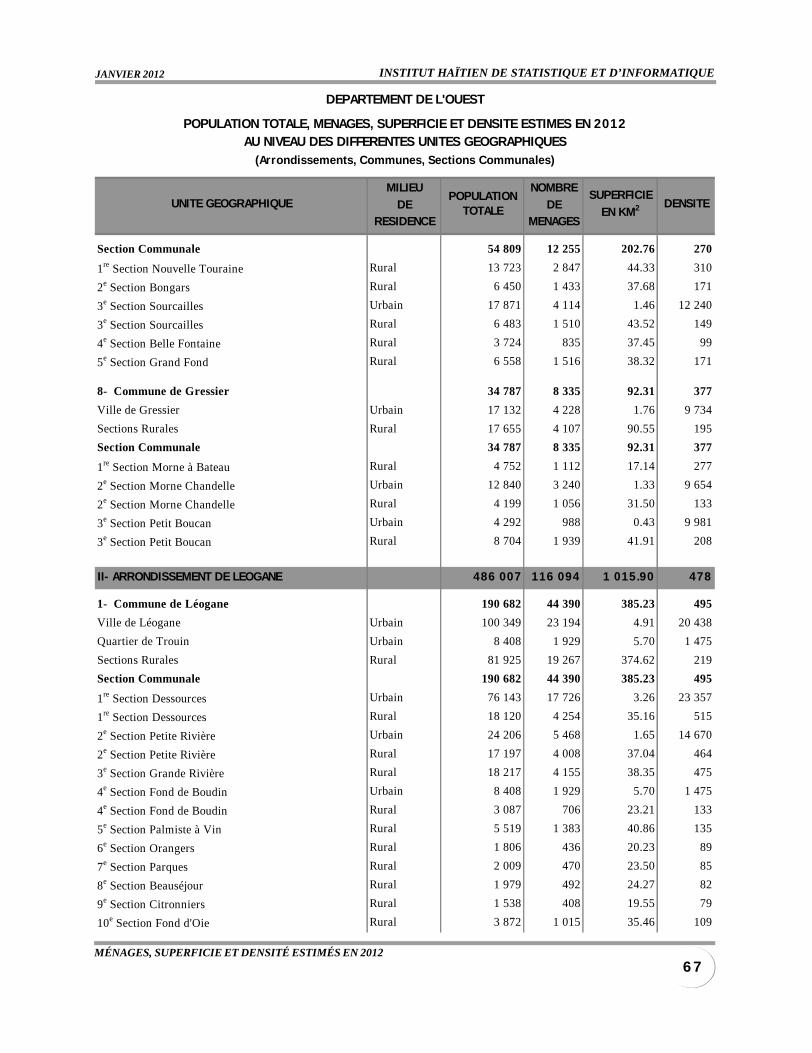
INSTITUT HAÏTIEN DE STATISTIQUE ET D’INFORMATIQUEJANVIER 2012
6 7MÉNAGES, SUPERFICIE ET DENSITÉ ESTIMÉS EN 2012
MILIEU NOMBRE
DE DERESIDENCE MENAGES
Section Communale 54 809 12 255 202.76 270
1re Section Nouvelle Touraine Rural 13 723 2 847 44.33 310
2e Section Bongars Rural 6 450 1 433 37.68 171
3e Section Sourcailles Urbain 17 871 4 114 1.46 12 240
3e Section Sourcailles Rural 6 483 1 510 43.52 149
4e Section Belle Fontaine Rural 3 724 835 37.45 99
5e Section Grand Fond Rural 6 558 1 516 38.32 171
8- Commune de Gressier 34 787 8 335 92.31 377
Ville de Gressier Urbain 17 132 4 228 1.76 9 734
Sections Rurales Rural 17 655 4 107 90.55 195
Section Communale 34 787 8 335 92.31 377
1re Section Morne à Bateau Rural 4 752 1 112 17.14 277
2e Section Morne Chandelle Urbain 12 840 3 240 1.33 9 654
2e Section Morne Chandelle Rural 4 199 1 056 31.50 133
3e Section Petit Boucan Urbain 4 292 988 0.43 9 981
3e Section Petit Boucan Rural 8 704 1 939 41.91 208
II- ARRONDISSEMENT DE LEOGANE 486 007 116 094 1 015.90 478
1- Commune de Léogane 190 682 44 390 385.23 495
Ville de Léogane Urbain 100 349 23 194 4.91 20 438
Quartier de Trouin Urbain 8 408 1 929 5.70 1 475
Sections Rurales Rural 81 925 19 267 374.62 219
Section Communale 190 682 44 390 385.23 495
1re Section Dessources Urbain 76 143 17 726 3.26 23 357
1re Section Dessources Rural 18 120 4 254 35.16 515
2e Section Petite Rivière Urbain 24 206 5 468 1.65 14 670
2e Section Petite Rivière Rural 17 197 4 008 37.04 464
3e Section Grande Rivière Rural 18 217 4 155 38.35 475
4e Section Fond de Boudin Urbain 8 408 1 929 5.70 1 475
4e Section Fond de Boudin Rural 3 087 706 23.21 133
5e Section Palmiste à Vin Rural 5 519 1 383 40.86 135
6e Section Orangers Rural 1 806 436 20.23 89
7e Section Parques Rural 2 009 470 23.50 85
8e Section Beauséjour Rural 1 979 492 24.27 82
9e Section Citronniers Rural 1 538 408 19.55 79
10e Section Fond d'Oie Rural 3 872 1 015 35.46 109
POPULATIONTOTALE
SUPERFICIE
EN KM2 DENSITE
DEPARTEMENT DE L'OUEST
POPULATION TOTALE, MENAGES, SUPERFICIE ET DENSITE ESTIMES EN 2012AU NIVEAU DES DIFFERENTES UNITES GEOGRAPHIQUES
(Arrondissements, Communes, Sections Communales)
UNITE GEOGRAPHIQUE
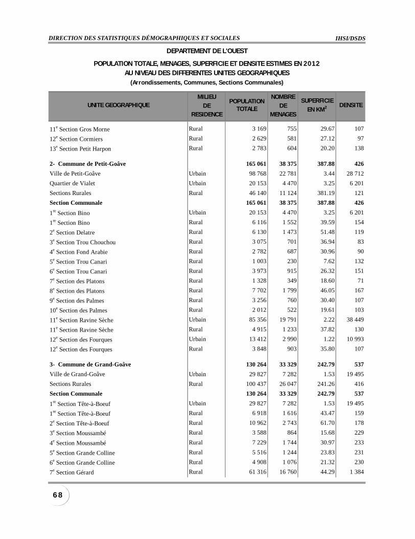
IHSI/DSDSDIRECTION DES STATISTIQUES DÉMOGRAPHIQUES ET SOCIALES
6 8
MILIEU NOMBRE
DE DERESIDENCE MENAGES
11e Section Gros Morne Rural 3 169 755 29.67 107
12e Section Cormiers Rural 2 629 581 27.12 97
13e Section Petit Harpon Rural 2 783 604 20.20 138
2- Commune de Petit-Goâve 165 061 38 375 387.88 426
Ville de Petit-Goâve Urbain 98 768 22 781 3.44 28 712
Quartier de Vialet Urbain 20 153 4 470 3.25 6 201
Sections Rurales Rural 46 140 11 124 381.19 121
Section Communale 165 061 38 375 387.88 426
1re Section Bino Urbain 20 153 4 470 3.25 6 201
1re Section Bino Rural 6 116 1 552 39.59 154
2e Section Delatre Rural 6 130 1 473 51.48 119
3e Section Trou Chouchou Rural 3 075 701 36.94 83
4e Section Fond Arabie Rural 2 782 687 30.96 90
5e Section Trou Canari Rural 1 003 230 7.62 132
6e Section Trou Canari Rural 3 973 915 26.32 151
7e Section des Platons Rural 1 328 349 18.60 71
8e Section des Platons Rural 7 702 1 799 46.05 167
9e Section des Palmes Rural 3 256 760 30.40 107
10e Section des Palmes Rural 2 012 522 19.61 103
11e Section Ravine Sèche Urbain 85 356 19 791 2.22 38 449
11e Section Ravine Sèche Rural 4 915 1 233 37.82 130
12e Section des Fourques Urbain 13 412 2 990 1.22 10 993
12e Section des Fourques Rural 3 848 903 35.80 107
3- Commune de Grand-Goâve 130 264 33 329 242.79 537
Ville de Grand-Goâve Urbain 29 827 7 282 1.53 19 495
Sections Rurales Rural 100 437 26 047 241.26 416
Section Communale 130 264 33 329 242.79 537
1re Section Tête-à-Boeuf Urbain 29 827 7 282 1.53 19 495
1re Section Tête-à-Boeuf Rural 6 918 1 616 43.47 159
2e Section Tête-à-Boeuf Rural 10 962 2 743 61.70 178
3e Section Moussambé Rural 3 588 864 15.68 229
4e Section Moussambé Rural 7 229 1 744 30.97 233
5e Section Grande Colline Rural 5 516 1 244 23.83 231
6e Section Grande Colline Rural 4 908 1 076 21.32 230
7e Section Gérard Rural 61 316 16 760 44.29 1 384
POPULATIONTOTALE
SUPERFICIE
EN KM2 DENSITE
DEPARTEMENT DE L'OUEST
POPULATION TOTALE, MENAGES, SUPERFICIE ET DENSITE ESTIMES EN 2012AU NIVEAU DES DIFFERENTES UNITES GEOGRAPHIQUES
(Arrondissements, Communes, Sections Communales)
UNITE GEOGRAPHIQUE
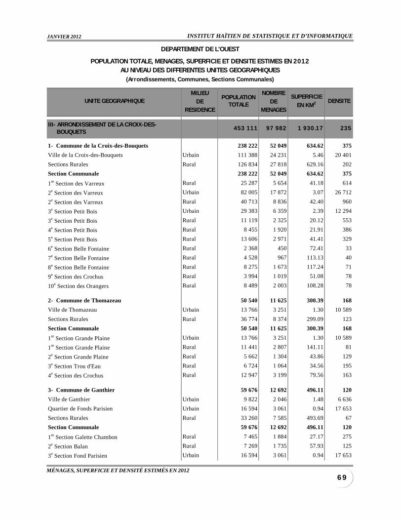
INSTITUT HAÏTIEN DE STATISTIQUE ET D’INFORMATIQUEJANVIER 2012
6 9MÉNAGES, SUPERFICIE ET DENSITÉ ESTIMÉS EN 2012
MILIEU NOMBRE
DE DERESIDENCE MENAGES
III- ARRONDISSEMENT DE LA CROIX-DES- BOUQUETS
453 111 97 982 1 930.17 235
1- Commune de la Croix-des-Bouquets 238 222 52 049 634.62 375
Ville de la Croix-des-Bouquets Urbain 111 388 24 231 5.46 20 401
Sections Rurales Rural 126 834 27 818 629.16 202
Section Communale 238 222 52 049 634.62 375
1re Section des Varreux Rural 25 287 5 654 41.18 614
2e Section des Varreux Urbain 82 005 17 872 3.07 26 712
2e Section des Varreux Rural 40 713 8 836 42.40 960
3e Section Petit Bois Urbain 29 383 6 359 2.39 12 294
3e Section Petit Bois Rural 11 119 2 325 20.12 553
4e Section Petit Bois Rural 8 455 1 920 21.91 386
5e Section Petit Bois Rural 13 606 2 971 41.41 329
6e Section Belle Fontaine Rural 2 368 450 72.41 33
7e Section Belle Fontaine Rural 4 528 967 113.13 40
8e Section Belle Fontaine Rural 8 275 1 673 117.24 71
9e Section des Crochus Rural 3 994 1 019 51.08 78
10e Section des Orangers Rural 8 489 2 003 108.28 78
2- Commune de Thomazeau 50 540 11 625 300.39 168
Ville de Thomazeau Urbain 13 766 3 251 1.30 10 589
Sections Rurales Rural 36 774 8 374 299.09 123
Section Communale 50 540 11 625 300.39 168
1re Section Grande Plaine Urbain 13 766 3 251 1.30 10 589
1re Section Grande Plaine Rural 11 441 2 807 141.11 81
2e Section Grande Plaine Rural 5 662 1 304 43.86 129
3e Section Trou d'Eau Rural 6 724 1 064 34.56 195
4e Section des Crochus Rural 12 947 3 199 79.56 163
3- Commune de Ganthier 59 676 12 692 496.11 120
Ville de Ganthier Urbain 9 822 2 046 1.48 6 636
Quartier de Fonds Parisien Urbain 16 594 3 061 0.94 17 653
Sections Rurales Rural 33 260 7 585 493.69 67
Section Communale 59 676 12 692 496.11 120
1re Section Galette Chambon Rural 7 465 1 884 27.17 275
2e Section Balan Rural 7 269 1 735 57.93 125
3e Section Fond Parisien Urbain 16 594 3 061 0.94 17 653
POPULATIONTOTALE
SUPERFICIE
EN KM2 DENSITE
DEPARTEMENT DE L'OUEST
POPULATION TOTALE, MENAGES, SUPERFICIE ET DENSITE ESTIMES EN 2012AU NIVEAU DES DIFFERENTES UNITES GEOGRAPHIQUES
(Arrondissements, Communes, Sections Communales)
UNITE GEOGRAPHIQUE
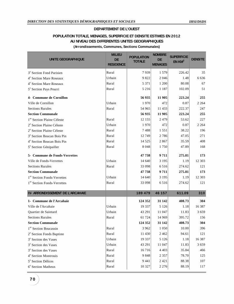
IHSI/DSDSDIRECTION DES STATISTIQUES DÉMOGRAPHIQUES ET SOCIALES
7 0
MILIEU NOMBRE
DE DERESIDENCE MENAGES
3e Section Fond Parisien Rural 7 939 1 579 226.42 35
4e Section Mare Roseaux Urbain 9 822 2 046 1.48 6 636
4e Section Mare Roseaux Rural 5 371 1 200 80.08 67
5e Section Pays Pourri Rural 5 216 1 187 102.09 51
4- Commune de Cornillon 56 935 11 905 223.24 255
Ville de Cornillon Urbain 1 970 472 0.87 2 264
Sections Rurales Rural 54 965 11 433 222.37 247
Section Communale 56 935 11 905 223.24 255
1re Section Plaine Céleste Rural 12 155 2 479 53.62 227
2e Section Plaine Céleste Urbain 1 970 472 0.87 2 264
2e Section Plaine Céleste Rural 7 488 1 551 38.22 196
3e Section Boucan Bois Pin Rural 12 749 2 786 47.05 271
4e Section Boucan Bois Pin Rural 14 525 2 867 35.59 408
5e Section Génipailler Rural 8 048 1 750 47.89 168
5- Commune de Fonds-Verrettes 47 738 9 711 275.81 173
Ville de Fonds-Verrettes Urbain 14 640 3 195 1.19 12 303
Sections Rurales Rural 33 098 6 516 274.62 121
Section Communale 47 738 9 711 275.81 173
1re Section Fonds-Verrettes Urbain 14 640 3 195 1.19 12 303
1re Section Fonds-Verrettes Rural 33 098 6 516 274.62 121
IV- ARRONDISSEMENT DE L'ARCAHAIE 189 479 46 157 611.09 310
1- Commune de l'Arcahaie 124 352 31 142 408.73 304
Ville de l'Arcahaie Urbain 19 337 5 126 1.18 16 387
Quartier de Saintard Urbain 43 291 11 047 11.83 3 659
Sections Rurales Rural 61 724 14 969 395.72 156
Section Communale 124 352 31 142 408.73 304
1re Section Boucassin Rural 3 962 1 050 10.00 396
2e Section Fonds Baptiste Rural 11 430 2 462 94.61 121
3e Section des Vases Urbain 19 337 5 126 1.18 16 387
3e Section des Vases Urbain 43 291 11 047 11.83 3 659
3e Section des Vases Rural 16 716 4 403 35.84 466
4e Section Montrouis Rural 9 848 2 357 78.70 125
5e Section Délices Rural 9 441 2 421 88.38 107
6e Section Matheux Rural 10 327 2 276 88.19 117
POPULATIONTOTALE
SUPERFICIE
EN KM2 DENSITE
DEPARTEMENT DE L'OUEST
POPULATION TOTALE, MENAGES, SUPERFICIE ET DENSITE ESTIMES EN 2012AU NIVEAU DES DIFFERENTES UNITES GEOGRAPHIQUES
(Arrondissements, Communes, Sections Communales)
UNITE GEOGRAPHIQUE
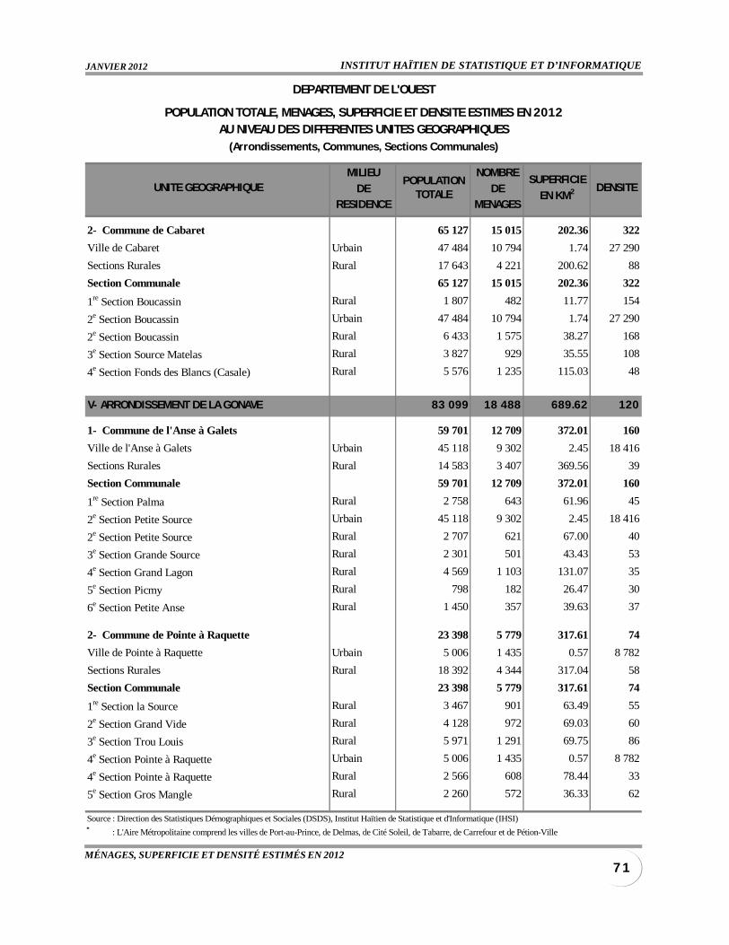
INSTITUT HAÏTIEN DE STATISTIQUE ET D’INFORMATIQUEJANVIER 2012
7 1MÉNAGES, SUPERFICIE ET DENSITÉ ESTIMÉS EN 2012
MILIEU NOMBRE
DE DERESIDENCE MENAGES
2- Commune de Cabaret 65 127 15 015 202.36 322
Ville de Cabaret Urbain 47 484 10 794 1.74 27 290
Sections Rurales Rural 17 643 4 221 200.62 88
Section Communale 65 127 15 015 202.36 322
1re Section Boucassin Rural 1 807 482 11.77 154
2e Section Boucassin Urbain 47 484 10 794 1.74 27 290
2e Section Boucassin Rural 6 433 1 575 38.27 168
3e Section Source Matelas Rural 3 827 929 35.55 108
4e Section Fonds des Blancs (Casale) Rural 5 576 1 235 115.03 48
V- ARRONDISSEMENT DE LA GONAVE 83 099 18 488 689.62 120
1- Commune de l'Anse à Galets 59 701 12 709 372.01 160
Ville de l'Anse à Galets Urbain 45 118 9 302 2.45 18 416
Sections Rurales Rural 14 583 3 407 369.56 39
Section Communale 59 701 12 709 372.01 160
1re Section Palma Rural 2 758 643 61.96 45
2e Section Petite Source Urbain 45 118 9 302 2.45 18 416
2e Section Petite Source Rural 2 707 621 67.00 40
3e Section Grande Source Rural 2 301 501 43.43 53
4e Section Grand Lagon Rural 4 569 1 103 131.07 35
5e Section Picmy Rural 798 182 26.47 30
6e Section Petite Anse Rural 1 450 357 39.63 37
2- Commune de Pointe à Raquette 23 398 5 779 317.61 74
Ville de Pointe à Raquette Urbain 5 006 1 435 0.57 8 782
Sections Rurales Rural 18 392 4 344 317.04 58
Section Communale 23 398 5 779 317.61 74
1re Section la Source Rural 3 467 901 63.49 55
2e Section Grand Vide Rural 4 128 972 69.03 60
3e Section Trou Louis Rural 5 971 1 291 69.75 86
4e Section Pointe à Raquette Urbain 5 006 1 435 0.57 8 782
4e Section Pointe à Raquette Rural 2 566 608 78.44 33
5e Section Gros Mangle Rural 2 260 572 36.33 62
Source : Direction des Statistiques Démographiques et Sociales (DSDS), Institut Haïtien de Statistique et d'Informatique (IHSI)
DEPARTEMENT DE L'OUEST
POPULATION TOTALE, MENAGES, SUPERFICIE ET DENSITE ESTIMES EN 2012AU NIVEAU DES DIFFERENTES UNITES GEOGRAPHIQUES
(Arrondissements, Communes, Sections Communales)
* : L'Aire Métropolitaine comprend les villes de Port-au-Prince, de Delmas, de Cité Soleil, de Tabarre, de Carrefour et de Pétion-Ville
POPULATIONTOTALE
SUPERFICIE
EN KM2 DENSITEUNITE GEOGRAPHIQUE
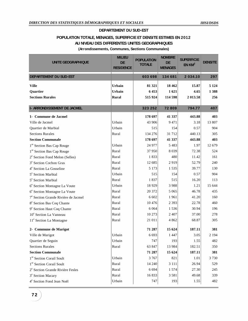
IHSI/DSDSDIRECTION DES STATISTIQUES DÉMOGRAPHIQUES ET SOCIALES
7 2
MILIEU NOMBRE
DE DERESIDENCE MENAGES
DEPARTEMENT DU SUD-EST 603 698 134 681 2 034.10 297
Ville Urbain 81 321 18 462 15.87 5 124
Quartier Urbain 6 453 1 621 4.65 1 388
Sections Rurales Rural 515 924 114 598 2 013.58 256
I- ARRONDISSEMENT DE JACMEL 323 252 72 809 794.77 407
1- Commune de Jacmel 178 697 41 337 443.88 403
Ville de Jacmel Urbain 43 906 9 471 3.18 13 807
Quartier de Marbial Urbain 515 154 0.57 904
Sections Rurales Rural 134 276 31 712 440.13 305
Section Communale 178 697 41 337 443.88 403
1re Section Bas Cap Rouge Urbain 24 977 5 483 1.97 12 679
1re Section Bas Cap Rouge Rural 37 950 8 039 72.38 524
2e Section Fond Melon (Selles) Rural 1 833 480 11.42 161
3e Section Cochon Gras Rural 12 685 2 919 52.79 240
4e Section La Gosseline Rural 5 173 1 535 39.77 130
5e Section Marbial Urbain 515 154 0.57 904
5e Section Marbial Rural 1 837 515 16.20 113
6e Section Montagne La Voute Urbain 18 929 3 988 1.21 15 644
6e Section Montagne La Voute Rural 20 372 5 065 46.78 435
7e Section Grande Rivière de Jacmel Rural 6 602 1 961 41.20 160
8e Section Bas Coq Chante Rural 10 476 2 393 22.78 460
9e Section Haut Coq Chante Rural 6 064 1 536 30.94 196
10e Section La Vanneau Rural 10 273 2 407 37.00 278
11e Section La Montagne Rural 21 011 4 862 68.87 305
2- Commune de Marigot 71 287 15 624 187.11 381
Ville de Marigot Urbain 6 693 1 447 3.05 2 194
Quartier de Seguin Urbain 747 193 1.55 482
Sections Rurales Rural 63 847 13 984 182.51 350
Section Communale 71 287 15 624 187.11 381
1re Section Corail Soult Urbain 3 767 821 1.01 3 730
1re Section Corail Soult Rural 14 240 3 111 26.94 529
2e Section Grande Rivière Fesles Rural 6 694 1 574 27.30 245
3e Section Macary Rural 16 833 3 581 49.68 339
4e Section Fond Jean Noël Urbain 747 193 1.55 482
POPULATIONTOTALE
SUPERFICIE
EN KM2
DEPARTEMENT DU SUD-EST
POPULATION TOTALE, MENAGES, SUPERFICIE ET DENSITE ESTIMES EN 2012
AU NIVEAU DES DIFFERENTES UNITES GEOGRAPHIQUES(Arrondissements, Communes, Sections Communales)
UNITE GEOGRAPHIQUE DENSITE
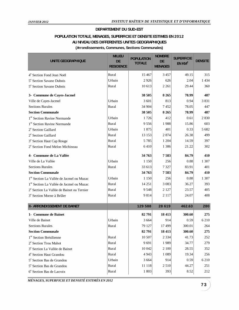
INSTITUT HAÏTIEN DE STATISTIQUE ET D’INFORMATIQUEJANVIER 2012
7 3MÉNAGES, SUPERFICIE ET DENSITÉ ESTIMÉS EN 2012
MILIEU NOMBRE
DE DERESIDENCE MENAGES
4e Section Fond Jean Noël Rural 15 467 3 457 49.15 315
5e Section Savane Dubois Urbain 2 926 626 2.04 1 434
5e Section Savane Dubois Rural 10 613 2 261 29.44 360
3- Commune de Cayes-Jacmel 38 505 8 265 78.99 487
Ville de Cayes-Jacmel Urbain 3 601 813 0.94 3 831
Sections Rurales Rural 34 904 7 452 78.05 447
Section Communale 38 505 8 265 78.99 487
1re Section Ravine Normande Urbain 1 726 412 0.61 2 830
1re Section Ravine Normande Rural 9 556 1 988 15.86 603
2e Section Gaillard Urbain 1 875 401 0.33 5 682
2e Section Gaillard Rural 13 153 2 874 26.38 499
3e Section Haut Cap Rouge Rural 5 785 1 204 14.59 397
2e Section Fond Melon Michineau Rural 6 410 1 386 21.22 302
4- Commune de La Vallée 34 763 7 583 84.79 410
Ville de La Vallée Urbain 1 150 256 0.88 1 307
Sections Rurales Rural 33 613 7 327 83.91 401
Section Communale 34 763 7 583 84.79 410
1re Section La Vallée de Jacmel ou Muzac Urbain 1 150 256 0.88 1 307
1re Section La Vallée de Jacmel ou Muzac Rural 14 251 3 083 36.27 393
2e Section La Vallée de Bainet ou Ternier Rural 9 548 2 127 23.57 405
3e Section Morne à Brûler Rural 9 814 2 117 24.07 408
II- ARRONDISSEMENT DE BAINET 129 588 28 619 462.63 280
1- Commune de Bainet 82 791 18 413 300.60 275
Ville de Bainet Urbain 3 664 914 0.59 6 210
Sections Rurales Rural 79 127 17 499 300.01 264
Section Communale 82 791 18 413 300.60 275
1re Section Brésilienne Rural 10 507 2 334 41.73 252
2e Section Trou Mahot Rural 9 691 1 989 34.77 279
3e Section La Vallée de Bainet Rural 10 042 2 100 28.55 352
4e Section Haut Grandou Rural 4 943 1 089 19.34 256
5e Section Bas de Grandou Urbain 3 664 914 0.59 6 210
5e Section Bas de Grandou Rural 11 118 2 510 44.27 251
6e Section Bas de Lacroix Rural 1 803 393 8.52 212
POPULATIONTOTALE
SUPERFICIE
EN KM2
DEPARTEMENT DU SUD-EST
POPULATION TOTALE, MENAGES, SUPERFICIE ET DENSITE ESTIMES EN 2012
AU NIVEAU DES DIFFERENTES UNITES GEOGRAPHIQUES(Arrondissements, Communes, Sections Communales)
UNITE GEOGRAPHIQUE DENSITE
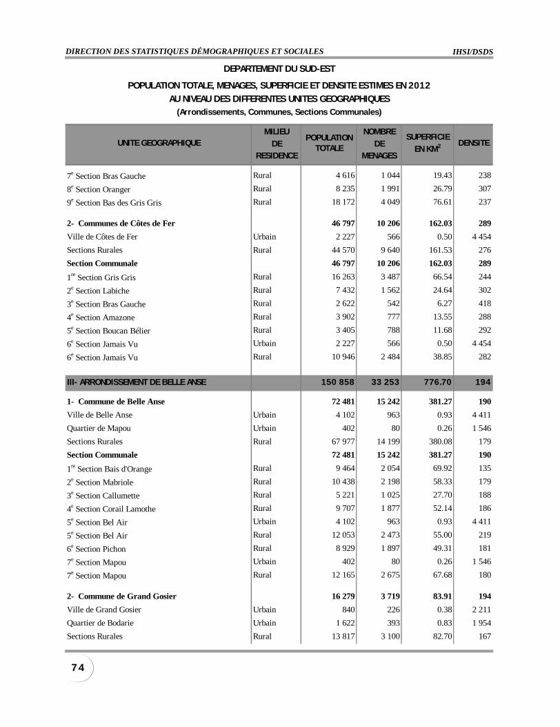
IHSI/DSDSDIRECTION DES STATISTIQUES DÉMOGRAPHIQUES ET SOCIALES
7 4
MILIEU NOMBRE
DE DERESIDENCE MENAGES
7e Section Bras Gauche Rural 4 616 1 044 19.43 238
8e Section Oranger Rural 8 235 1 991 26.79 307
9e Section Bas des Gris Gris Rural 18 172 4 049 76.61 237
2- Communes de Côtes de Fer 46 797 10 206 162.03 289
Ville de Côtes de Fer Urbain 2 227 566 0.50 4 454
Sections Rurales Rural 44 570 9 640 161.53 276
Section Communale 46 797 10 206 162.03 289
1re Section Gris Gris Rural 16 263 3 487 66.54 244
2e Section Labiche Rural 7 432 1 562 24.64 302
3e Section Bras Gauche Rural 2 622 542 6.27 418
4e Section Amazone Rural 3 902 777 13.55 288
5e Section Boucan Bélier Rural 3 405 788 11.68 292
6e Section Jamais Vu Urbain 2 227 566 0.50 4 454
6e Section Jamais Vu Rural 10 946 2 484 38.85 282
III- ARRONDISSEMENT DE BELLE ANSE 150 858 33 253 776.70 194
1- Commune de Belle Anse 72 481 15 242 381.27 190
Ville de Belle Anse Urbain 4 102 963 0.93 4 411
Quartier de Mapou Urbain 402 80 0.26 1 546
Sections Rurales Rural 67 977 14 199 380.08 179
Section Communale 72 481 15 242 381.27 190
1re Section Bais d'Orange Rural 9 464 2 054 69.92 135
2e Section Mabriole Rural 10 438 2 198 58.33 179
3e Section Callumette Rural 5 221 1 025 27.70 188
4e Section Corail Lamothe Rural 9 707 1 877 52.14 186
5e Section Bel Air Urbain 4 102 963 0.93 4 411
5e Section Bel Air Rural 12 053 2 473 55.00 219
6e Section Pichon Rural 8 929 1 897 49.31 181
7e Section Mapou Urbain 402 80 0.26 1 546
7e Section Mapou Rural 12 165 2 675 67.68 180
2- Commune de Grand Gosier 16 279 3 719 83.91 194
Ville de Grand Gosier Urbain 840 226 0.38 2 211
Quartier de Bodarie Urbain 1 622 393 0.83 1 954
Sections Rurales Rural 13 817 3 100 82.70 167
POPULATIONTOTALE
SUPERFICIE
EN KM2
DEPARTEMENT DU SUD-EST
POPULATION TOTALE, MENAGES, SUPERFICIE ET DENSITE ESTIMES EN 2012
AU NIVEAU DES DIFFERENTES UNITES GEOGRAPHIQUES(Arrondissements, Communes, Sections Communales)
UNITE GEOGRAPHIQUE DENSITE

INSTITUT HAÏTIEN DE STATISTIQUE ET D’INFORMATIQUEJANVIER 2012
7 5MÉNAGES, SUPERFICIE ET DENSITÉ ESTIMÉS EN 2012
MILIEU NOMBRE
DE DERESIDENCE MENAGES
Section Communale 16 279 3 719 83.91 194
1re Section Colline des Chênes ou Bodarie Urbain 840 226 0.38 2 211
1re Section Colline des Chênes ou Bodarie Urbain 1 622 393 0.83 1 954
1re Section Colline des Chênes ou Bodarie Rural 13 817 3 100 82.70 167
3- Commune de Thiotte 33 329 7 360 126.33 264
Ville de Thiotte Urbain 6 228 1 528 2.41 2 584
Sections Rurales Rural 27 101 5 832 123.92 219
Section Communale 33 329 7 360 126.33 264
1re Section Thiotte Urbain 6 228 1 528 2.41 2 584
1re Section Thiotte Rural 17 715 3 777 71.26 249
2e Section Pot de Chambre Rural 9 386 2 055 52.66 178
4- Commune de l'Anse-à-Pitre 28 769 6 932 185.19 155
Ville de l'Anse-à-Pitre Urbain 8 910 2 278 3.01 2 960
Quartier de Banane Urbain 3 167 801 1.44 2 199
Sections Rurales Rural 16 692 3 853 180.74 92
Section Communale 28 769 6 932 185.19 155
1re Section Boucan Guillaume Urbain 8 910 2 278 3.01 2 960
1re Section Boucan Guillaume Urbain 3 167 801 1.44 2 199
1re Section Boucan Guillaume Rural 3 785 1 073 121.16 31
2e Section Bois d'Orme Rural 12 907 2 780 59.58 217
Source : Direction des Statistiques Démographiques et Sociales (DSDS), Institut Haïtien de Statistique et d'Informatique (IHSI)
POPULATIONTOTALE
SUPERFICIE
EN KM2
DEPARTEMENT DU SUD-EST
POPULATION TOTALE, MENAGES, SUPERFICIE ET DENSITE ESTIMES EN 2012
AU NIVEAU DES DIFFERENTES UNITES GEOGRAPHIQUES(Arrondissements, Communes, Sections Communales)
UNITE GEOGRAPHIQUE DENSITE
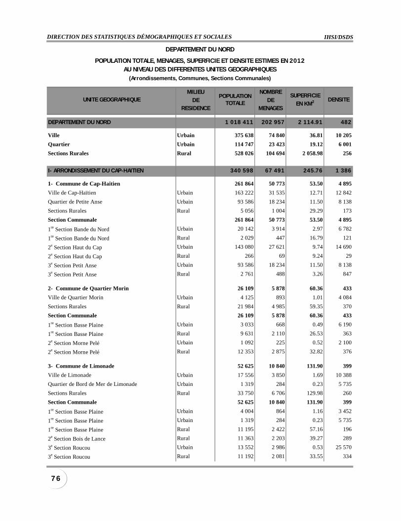
IHSI/DSDSDIRECTION DES STATISTIQUES DÉMOGRAPHIQUES ET SOCIALES
7 6
MILIEU NOMBRE
DE DERESIDENCE MENAGES
DEPARTEMENT DU NORD 1 018 411 202 957 2 114.91 482
Ville Urbain 375 638 74 840 36.81 10 205
Quartier Urbain 114 747 23 423 19.12 6 001
Sections Rurales Rural 528 026 104 694 2 058.98 256
I- ARRONDISSEMENT DU CAP-HAITIEN 340 598 67 491 245.76 1 386
1- Commune de Cap-Haïtien 261 864 50 773 53.50 4 895
Ville de Cap-Haïtien Urbain 163 222 31 535 12.71 12 842
Quartier de Petite Anse Urbain 93 586 18 234 11.50 8 138
Sections Rurales Rural 5 056 1 004 29.29 173
Section Communale 261 864 50 773 53.50 4 895
1re Section Bande du Nord Urbain 20 142 3 914 2.97 6 782
1re Section Bande du Nord Rural 2 029 447 16.79 121
2e Section Haut du Cap Urbain 143 080 27 621 9.74 14 690
2e Section Haut du Cap Rural 266 69 9.24 29
3e Section Petit Anse Urbain 93 586 18 234 11.50 8 138
3e Section Petit Anse Rural 2 761 488 3.26 847
2- Commune de Quartier Morin 26 109 5 878 60.36 433
Ville de Quartier Morin Urbain 4 125 893 1.01 4 084
Sections Rurales Rural 21 984 4 985 59.35 370
Section Communale 26 109 5 878 60.36 433
1re Section Basse Plaine Urbain 3 033 668 0.49 6 190
1re Section Basse Plaine Rural 9 631 2 110 26.53 363
2e Section Morne Pelé Urbain 1 092 225 0.52 2 100
2e Section Morne Pelé Rural 12 353 2 875 32.82 376
3- Commune de Limonade 52 625 10 840 131.90 399
Ville de Limonade Urbain 17 556 3 850 1.69 10 388
Quartier de Bord de Mer de Limonade Urbain 1 319 284 0.23 5 735
Sections Rurales Rural 33 750 6 706 129.98 260
Section Communale 52 625 10 840 131.90 399
1re Section Basse Plaine Urbain 4 004 864 1.16 3 452
1re Section Basse Plaine Urbain 1 319 284 0.23 5 735
1re Section Basse Plaine Rural 11 195 2 422 57.16 196
2e Section Bois de Lance Rural 11 363 2 203 39.27 289
3e Section Roucou Urbain 13 552 2 986 0.53 25 570
3e Section Roucou Rural 11 192 2 081 33.55 334
DEPARTEMENT DU NORD
POPULATIONTOTALE
SUPERFICIE
EN KM2
POPULATION TOTALE, MENAGES, SUPERFICIE ET DENSITE ESTIMES EN 2012AU NIVEAU DES DIFFERENTES UNITES GEOGRAPHIQUES
(Arrondissements, Communes, Sections Communales)
UNITE GEOGRAPHIQUE DENSITE
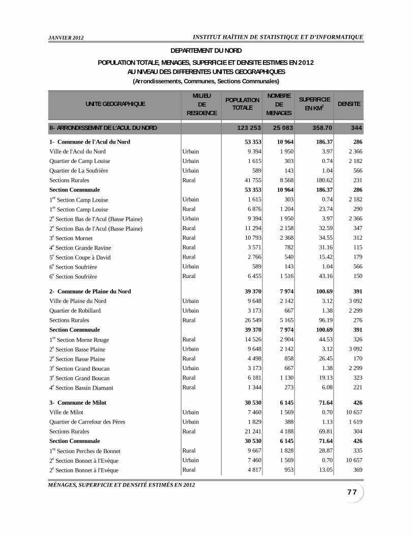
INSTITUT HAÏTIEN DE STATISTIQUE ET D’INFORMATIQUEJANVIER 2012
7 7MÉNAGES, SUPERFICIE ET DENSITÉ ESTIMÉS EN 2012
MILIEU NOMBRE
DE DERESIDENCE MENAGES
II- ARRONDISSEMNT DE L'ACUL DU NORD 123 253 25 083 358.70 344
1- Commune de l'Acul du Nord 53 353 10 964 186.37 286
Ville de l'Acul du Nord Urbain 9 394 1 950 3.97 2 366
Quartier de Camp Louise Urbain 1 615 303 0.74 2 182
Quartier de La Soufrière Urbain 589 143 1.04 566
Sections Rurales Rural 41 755 8 568 180.62 231
Section Communale 53 353 10 964 186.37 286
1re Section Camp Louise Urbain 1 615 303 0.74 2 182
1re Section Camp Louise Rural 6 876 1 204 23.74 290
2e Section Bas de l'Acul (Basse Plaine) Urbain 9 394 1 950 3.97 2 366
2e Section Bas de l'Acul (Basse Plaine) Rural 11 294 2 158 32.59 347
3e Section Mornet Rural 10 793 2 368 34.55 312
4e Section Grande Ravine Rural 3 571 782 31.16 115
5e Section Coupe à David Rural 2 766 540 15.42 179
6e Section Soufrière Urbain 589 143 1.04 566
6e Section Soufrière Rural 6 455 1 516 43.16 150
2- Commune de Plaine du Nord 39 370 7 974 100.69 391
Ville de Plaine du Nord Urbain 9 648 2 142 3.12 3 092
Quartier de Robillard Urbain 3 173 667 1.38 2 299
Sections Rurales Rural 26 549 5 165 96.19 276
Section Communale 39 370 7 974 100.69 391
1re Section Morne Rouge Rural 14 526 2 904 44.53 326
2e Section Basse Plaine Urbain 9 648 2 142 3.12 3 092
2e Section Basse Plaine Rural 4 498 858 26.45 170
3e Section Grand Boucan Urbain 3 173 667 1.38 2 299
3e Section Grand Boucan Rural 6 181 1 130 19.13 323
4e Section Bassin Diamant Rural 1 344 273 6.08 221
3- Commune de Milot 30 530 6 145 71.64 426
Ville de Milot Urbain 7 460 1 569 0.70 10 657
Quartier de Carrefour des Pères Urbain 1 829 388 1.13 1 619
Sections Rurales Rural 21 241 4 188 69.81 304
Section Communale 30 530 6 145 71.64 426
1re Section Perches de Bonnet Rural 9 667 1 828 28.87 335
2e Section Bonnet à l'Evèque Urbain 7 460 1 569 0.70 10 657
2e Section Bonnet à l'Evèque Rural 4 817 953 13.05 369
DEPARTEMENT DU NORD
POPULATIONTOTALE
SUPERFICIE
EN KM2
POPULATION TOTALE, MENAGES, SUPERFICIE ET DENSITE ESTIMES EN 2012AU NIVEAU DES DIFFERENTES UNITES GEOGRAPHIQUES
(Arrondissements, Communes, Sections Communales)
UNITE GEOGRAPHIQUE DENSITE
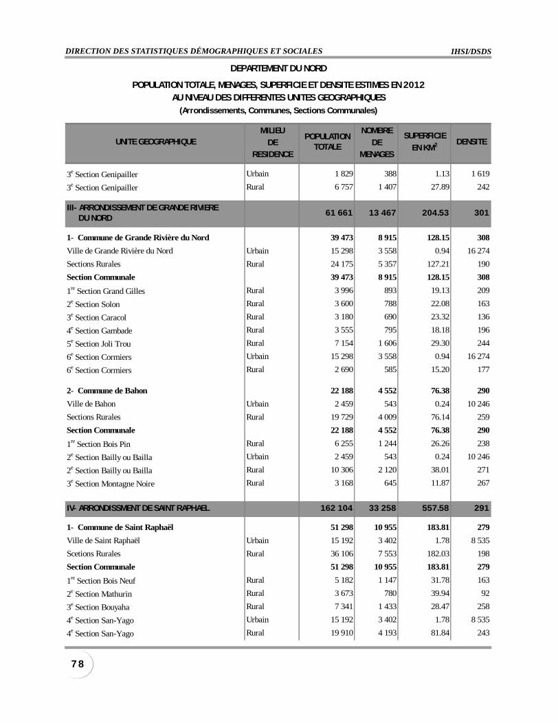
IHSI/DSDSDIRECTION DES STATISTIQUES DÉMOGRAPHIQUES ET SOCIALES
7 8
MILIEU NOMBRE
DE DERESIDENCE MENAGES
3e Section Genipailler Urbain 1 829 388 1.13 1 619
3e Section Genipailler Rural 6 757 1 407 27.89 242
III- ARRONDISSEMENT DE GRANDE RIVIERE DU NORD
61 661 13 467 204.53 301
1- Commune de Grande Rivière du Nord 39 473 8 915 128.15 308
Ville de Grande Rivière du Nord Urbain 15 298 3 558 0.94 16 274
Sections Rurales Rural 24 175 5 357 127.21 190
Section Communale 39 473 8 915 128.15 308
1re Section Grand Gilles Rural 3 996 893 19.13 209
2e Section Solon Rural 3 600 788 22.08 163
3e Section Caracol Rural 3 180 690 23.32 136
4e Section Gambade Rural 3 555 795 18.18 196
5e Section Joli Trou Rural 7 154 1 606 29.30 244
6e Section Cormiers Urbain 15 298 3 558 0.94 16 274
6e Section Cormiers Rural 2 690 585 15.20 177
2- Commune de Bahon 22 188 4 552 76.38 290
Ville de Bahon Urbain 2 459 543 0.24 10 246
Sections Rurales Rural 19 729 4 009 76.14 259
Section Communale 22 188 4 552 76.38 290
1re Section Bois Pin Rural 6 255 1 244 26.26 238
2e Section Bailly ou Bailla Urbain 2 459 543 0.24 10 246
2e Section Bailly ou Bailla Rural 10 306 2 120 38.01 271
3e Section Montagne Noire Rural 3 168 645 11.87 267
IV- ARRONDISSMENT DE SAINT RAPHAEL 162 104 33 258 557.58 291
1- Commune de Saint Raphaël 51 298 10 955 183.81 279
Ville de Saint Raphaël Urbain 15 192 3 402 1.78 8 535
Scetions Rurales Rural 36 106 7 553 182.03 198
Section Communale 51 298 10 955 183.81 279
1re Section Bois Neuf Rural 5 182 1 147 31.78 163
2e Section Mathurin Rural 3 673 780 39.94 92
3e Section Bouyaha Rural 7 341 1 433 28.47 258
4e Section San-Yago Urbain 15 192 3 402 1.78 8 535
4e Section San-Yago Rural 19 910 4 193 81.84 243
DEPARTEMENT DU NORD
POPULATIONTOTALE
SUPERFICIE
EN KM2
POPULATION TOTALE, MENAGES, SUPERFICIE ET DENSITE ESTIMES EN 2012AU NIVEAU DES DIFFERENTES UNITES GEOGRAPHIQUES
(Arrondissements, Communes, Sections Communales)
UNITE GEOGRAPHIQUE DENSITE
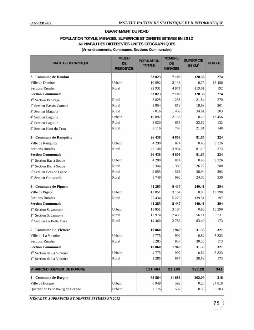
INSTITUT HAÏTIEN DE STATISTIQUE ET D’INFORMATIQUEJANVIER 2012
7 9MÉNAGES, SUPERFICIE ET DENSITÉ ESTIMÉS EN 2012
MILIEU NOMBRE
DE DERESIDENCE MENAGES
2- Commune de Dondon 33 023 7 109 120.36 274
Ville de Dondon Urbain 10 092 2 138 0.75 13 456
Sections Rurales Rural 22 931 4 971 119.61 192
Section Communale 33 023 7 109 120.36 274
1re Section Brostage Rural 5 825 1 238 21.54 270
2e Section Bassin Caïman Rural 3 954 813 19.63 201
3e Section Matador Rural 7 016 1 469 34.61 203
4e Section Laguille Urbain 10 092 2 138 0.75 13 456
4e Section Laguille Rural 3 020 658 22.82 132
5e Section Haut du Trou Rural 3 116 793 21.01 148
3- Commune de Ranquitte 26 438 4 808 81.65 324
Ville de Ranquitte Urbain 4 290 874 0.46 9 326
Sections Rurales Rural 22 148 3 934 81.19 273
Section Communale 26 438 4 808 81.65 324
1re Section Bac à Soude Urbain 4 290 874 0.46 9 326
1re Section Bac à Soude Rural 7 344 1 380 26.22 280
2e Section Bois de Lance Rural 9 055 1 561 30.94 293
3e Section Cracaraille Rural 5 749 993 24.03 239
4- Commune de Pignon 41 285 8 437 140.41 294
Ville de Pignon Urbain 13 851 3 164 0.90 15 390
Sections Rurales Rural 27 434 5 273 139.51 197
Section Communale 41 285 8 437 140.41 294
1re Section Savannette Urbain 13 851 3 164 0.90 15 390
1re Section Savannette Rural 12 974 2 485 56.11 231
2e Section La Belle Mère Rural 14 460 2 788 83.40 173
5- Commune La Victoire 10 060 1 949 31.35 321
Ville de La Victoire Urbain 4 775 992 0.82 5 823
Sections Rurales Rural 5 285 957 30.53 173
Section Communale 10 060 1 949 31.35 321
1re Section de La Victoire Urbain 4 775 992 0.82 5 823
1re Section de La Victoire Rural 5 285 957 30.53 173
V- ARRONDISSEMENT DE BORGNE 111 464 21 169 327.28 341
1- Commune de Borgne 63 864 11 686 202.09 316
Ville de Borgne Urbain 6 949 592 0.28 24 818
Quartier de Petit Bourg de Borgne Urbain 3 176 1 507 0.59 5 383
DEPARTEMENT DU NORD
POPULATIONTOTALE
SUPERFICIE
EN KM2
POPULATION TOTALE, MENAGES, SUPERFICIE ET DENSITE ESTIMES EN 2012AU NIVEAU DES DIFFERENTES UNITES GEOGRAPHIQUES
(Arrondissements, Communes, Sections Communales)
UNITE GEOGRAPHIQUE DENSITE
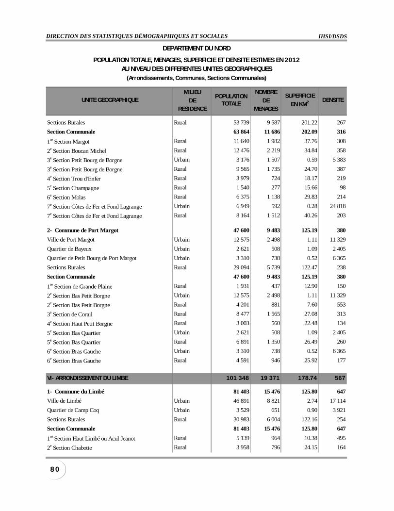
IHSI/DSDSDIRECTION DES STATISTIQUES DÉMOGRAPHIQUES ET SOCIALES
8 0
MILIEU NOMBRE
DE DERESIDENCE MENAGES
Sections Rurales Rural 53 739 9 587 201.22 267
Section Communale 63 864 11 686 202.09 316
1re Section Margot Rural 11 640 1 982 37.76 308
2e Section Boucan Michel Rural 12 476 2 219 34.84 358
3e Section Petit Bourg de Borgne Urbain 3 176 1 507 0.59 5 383
3e Section Petit Bourg de Borgne Rural 9 565 1 735 24.70 387
4e Section Trou d'Enfer Rural 3 979 724 18.17 219
5e Section Champagne Rural 1 540 277 15.66 98
6e Section Molas Rural 6 375 1 138 29.83 214
7e Section Côtes de Fer et Fond Lagrange Urbain 6 949 592 0.28 24 818
7e Section Côtes de Fer et Fond Lagrange Rural 8 164 1 512 40.26 203
2- Commune de Port Margot 47 600 9 483 125.19 380
Ville de Port Margot Urbain 12 575 2 498 1.11 11 329
Quartier de Bayeux Urbain 2 621 508 1.09 2 405
Quartier de Petit Bourg de Port Margot Urbain 3 310 738 0.52 6 365
Sections Rurales Rural 29 094 5 739 122.47 238
Section Communale 47 600 9 483 125.19 380
1re Section de Grande Plaine Rural 1 931 437 12.90 150
2e Section Bas Petit Borgne Urbain 12 575 2 498 1.11 11 329
2e Section Bas Petit Borgne Rural 4 201 881 7.60 553
3e Section de Corail Rural 8 477 1 565 27.08 313
4e Section Haut Petit Borgne Rural 3 003 560 22.48 134
5e Section Bas Quartier Urbain 2 621 508 1.09 2 405
5e Section Bas Quartier Rural 6 891 1 350 26.49 260
6e Section Bras Gauche Urbain 3 310 738 0.52 6 365
6e Section Bras Gauche Rural 4 591 946 25.92 177
VI- ARRONDISSEMENT DU LIMBE 101 348 19 371 178.74 567
1- Commune du Limbé 81 403 15 476 125.80 647
Ville de Limbé Urbain 46 891 8 821 2.74 17 114
Quartier de Camp Coq Urbain 3 529 651 0.90 3 921
Sections Rurales Rural 30 983 6 004 122.16 254
Section Communale 81 403 15 476 125.80 647
1re Section Haut Limbé ou Acul Jeanot Rural 5 139 964 10.38 495
2e Section Chabotte Rural 3 958 796 24.15 164
DEPARTEMENT DU NORD
POPULATIONTOTALE
SUPERFICIE
EN KM2
POPULATION TOTALE, MENAGES, SUPERFICIE ET DENSITE ESTIMES EN 2012AU NIVEAU DES DIFFERENTES UNITES GEOGRAPHIQUES
(Arrondissements, Communes, Sections Communales)
UNITE GEOGRAPHIQUE DENSITE
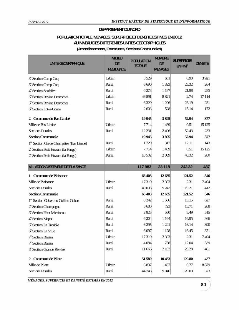
INSTITUT HAÏTIEN DE STATISTIQUE ET D’INFORMATIQUEJANVIER 2012
8 1MÉNAGES, SUPERFICIE ET DENSITÉ ESTIMÉS EN 2012
MILIEU NOMBRE
DE DERESIDENCE MENAGES
3e Section Camp Coq Urbain 3 529 651 0.90 3 921
3e Section Camp Coq Rural 6 690 1 323 25.32 264
4e Section Soufrière Rural 6 273 1 187 21.98 285
5e Section Ravine Desroches Urbain 46 891 8 821 2.74 17 114
5e Section Ravine Desroches Rural 6 320 1 206 25.19 251
6e Section Ilot-à-Corne Rural 2 603 528 15.14 172
2- Commune du Bas Limbé 19 945 3 895 52.94 377
Ville de Bas Limbé Urbain 7 714 1 489 0.51 15 125
Sections Rurales Rural 12 231 2 406 52.43 233
Section Communale 19 945 3 895 52.94 377
1re Section Garde Champètre (Bas Limbé) Rural 1 729 317 12.11 143
2e Section Petit Howars (la Fange) Urbain 7 714 1 489 0.51 15 125
2e Section Petit Howars (la Fange) Rural 10 502 2 089 40.32 260
VII- ARRONDISSEMENT DE PLAISANCE 117 983 23 118 242.32 487
1- Commune de Plaisance 66 403 12 635 121.52 546
Ville de Plaisance Urbain 17 310 3 393 2.31 7 494
Sections Rurales Rural 49 093 9 242 119.21 412
Section Communale 66 403 12 635 121.52 546
1re Section Gobert ou Colline Gobert Rural 8 242 1 586 13.15 627
2e Section Champagne Rural 3 680 723 13.71 268
3e Section Haut Martineau Rural 2 825 560 5.49 515
4e Section Mapou Rural 6 204 1 164 16.95 366
5e Section La Trouble Rural 6 295 1 241 16.14 390
6e Section La Ville Rural 6 097 1 128 16.45 371
7e Section Bassin Urbain 17 310 3 393 2.31 7 494
7e Section Bassin Rural 4 084 738 12.04 339
8e Section Grande Rivière Rural 11 666 2 102 25.28 461
2- Commune de Pilate 51 580 10 483 120.80 427
Ville de Pilate Urbain 6 837 1 437 0.77 8 879
Sections Rurales Rural 44 743 9 046 120.03 373
DEPARTEMENT DU NORD
POPULATIONTOTALE
SUPERFICIE
EN KM2
POPULATION TOTALE, MENAGES, SUPERFICIE ET DENSITE ESTIMES EN 2012AU NIVEAU DES DIFFERENTES UNITES GEOGRAPHIQUES
(Arrondissements, Communes, Sections Communales)
UNITE GEOGRAPHIQUE DENSITE
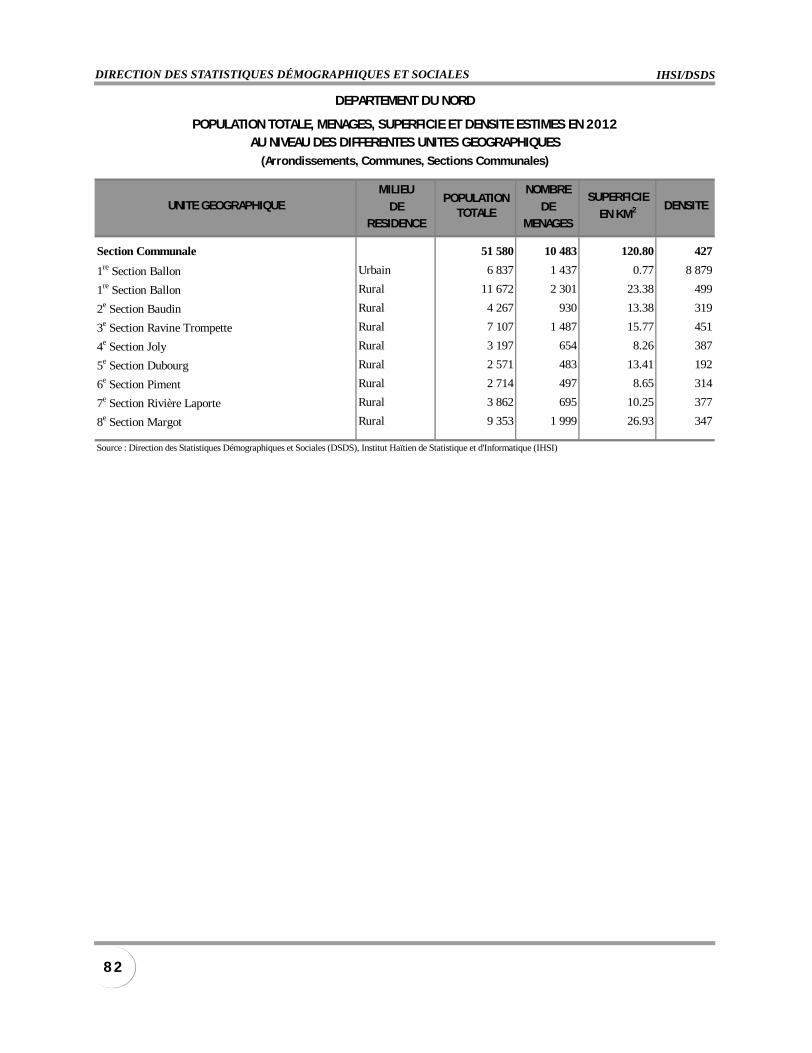
IHSI/DSDSDIRECTION DES STATISTIQUES DÉMOGRAPHIQUES ET SOCIALES
8 2
MILIEU NOMBRE
DE DERESIDENCE MENAGES
Section Communale 51 580 10 483 120.80 427
1re Section Ballon Urbain 6 837 1 437 0.77 8 879
1re Section Ballon Rural 11 672 2 301 23.38 499
2e Section Baudin Rural 4 267 930 13.38 319
3e Section Ravine Trompette Rural 7 107 1 487 15.77 451
4e Section Joly Rural 3 197 654 8.26 387
5e Section Dubourg Rural 2 571 483 13.41 192
6e Section Piment Rural 2 714 497 8.65 314
7e Section Rivière Laporte Rural 3 862 695 10.25 377
8e Section Margot Rural 9 353 1 999 26.93 347
Source : Direction des Statistiques Démographiques et Sociales (DSDS), Institut Haïtien de Statistique et d'Informatique (IHSI)
DEPARTEMENT DU NORD
POPULATIONTOTALE
SUPERFICIE
EN KM2
POPULATION TOTALE, MENAGES, SUPERFICIE ET DENSITE ESTIMES EN 2012AU NIVEAU DES DIFFERENTES UNITES GEOGRAPHIQUES
(Arrondissements, Communes, Sections Communales)
UNITE GEOGRAPHIQUE DENSITE
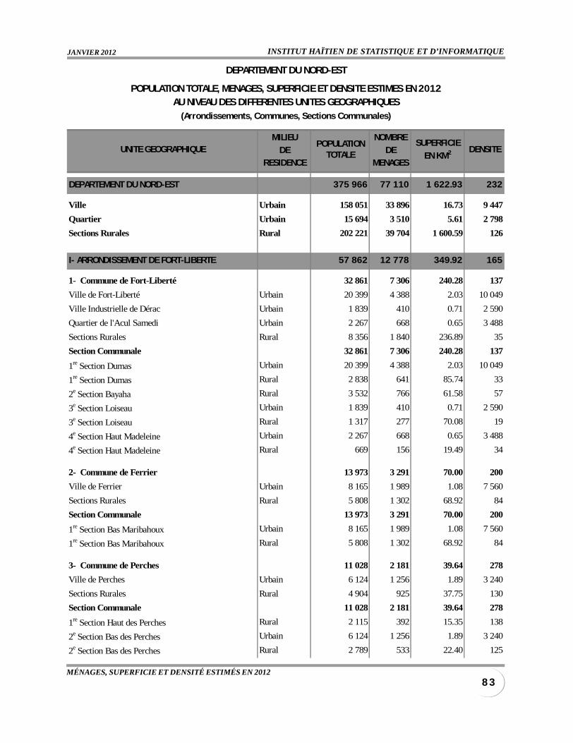
INSTITUT HAÏTIEN DE STATISTIQUE ET D’INFORMATIQUEJANVIER 2012
8 3MÉNAGES, SUPERFICIE ET DENSITÉ ESTIMÉS EN 2012
MILIEU NOMBRE
DE DERESIDENCE MENAGES
DEPARTEMENT DU NORD-EST 375 966 77 110 1 622.93 232
Ville Urbain 158 051 33 896 16.73 9 447
Quartier Urbain 15 694 3 510 5.61 2 798
Sections Rurales Rural 202 221 39 704 1 600.59 126
I- ARRONDISSEMENT DE FORT-LIBERTE 57 862 12 778 349.92 165
1- Commune de Fort-Liberté 32 861 7 306 240.28 137
Ville de Fort-Liberté Urbain 20 399 4 388 2.03 10 049
Ville Industrielle de Dérac Urbain 1 839 410 0.71 2 590
Quartier de l'Acul Samedi Urbain 2 267 668 0.65 3 488
Sections Rurales Rural 8 356 1 840 236.89 35
Section Communale 32 861 7 306 240.28 137
1re Section Dumas Urbain 20 399 4 388 2.03 10 049
1re Section Dumas Rural 2 838 641 85.74 33
2e Section Bayaha Rural 3 532 766 61.58 57
3e Section Loiseau Urbain 1 839 410 0.71 2 590
3e Section Loiseau Rural 1 317 277 70.08 19
4e Section Haut Madeleine Urbain 2 267 668 0.65 3 488
4e Section Haut Madeleine Rural 669 156 19.49 34
2- Commune de Ferrier 13 973 3 291 70.00 200
Ville de Ferrier Urbain 8 165 1 989 1.08 7 560
Sections Rurales Rural 5 808 1 302 68.92 84
Section Communale 13 973 3 291 70.00 200
1re Section Bas Maribahoux Urbain 8 165 1 989 1.08 7 560
1re Section Bas Maribahoux Rural 5 808 1 302 68.92 84
3- Commune de Perches 11 028 2 181 39.64 278
Ville de Perches Urbain 6 124 1 256 1.89 3 240
Sections Rurales Rural 4 904 925 37.75 130
Section Communale 11 028 2 181 39.64 278
1re Section Haut des Perches Rural 2 115 392 15.35 138
2e Section Bas des Perches Urbain 6 124 1 256 1.89 3 240
2e Section Bas des Perches Rural 2 789 533 22.40 125
POPULATIONTOTALE
SUPERFICIE
EN KM2
DEPARTEMENT DU NORD-EST
POPULATION TOTALE, MENAGES, SUPERFICIE ET DENSITE ESTIMES EN 2012AU NIVEAU DES DIFFERENTES UNITES GEOGRAPHIQUES
(Arrondissements, Communes, Sections Communales)
UNITE GEOGRAPHIQUE DENSITE
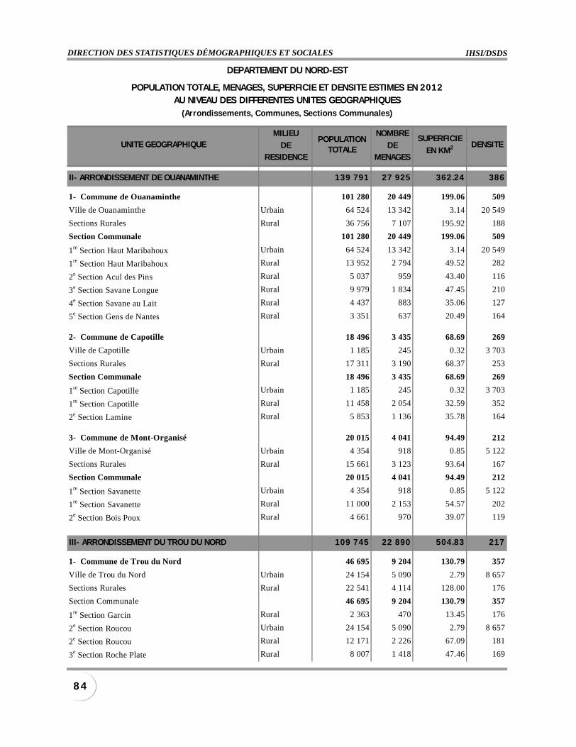
IHSI/DSDSDIRECTION DES STATISTIQUES DÉMOGRAPHIQUES ET SOCIALES
8 4
MILIEU NOMBRE
DE DERESIDENCE MENAGES
II- ARRONDISSEMENT DE OUANAMINTHE 139 791 27 925 362.24 386
1- Commune de Ouanaminthe 101 280 20 449 199.06 509
Ville de Ouanaminthe Urbain 64 524 13 342 3.14 20 549
Sections Rurales Rural 36 756 7 107 195.92 188
Section Communale 101 280 20 449 199.06 509
1re Section Haut Maribahoux Urbain 64 524 13 342 3.14 20 549
1re Section Haut Maribahoux Rural 13 952 2 794 49.52 282
2e Section Acul des Pins Rural 5 037 959 43.40 116
3e Section Savane Longue Rural 9 979 1 834 47.45 210
4e Section Savane au Lait Rural 4 437 883 35.06 127
5e Section Gens de Nantes Rural 3 351 637 20.49 164
2- Commune de Capotille 18 496 3 435 68.69 269
Ville de Capotille Urbain 1 185 245 0.32 3 703
Sections Rurales Rural 17 311 3 190 68.37 253
Section Communale 18 496 3 435 68.69 269
1re Section Capotille Urbain 1 185 245 0.32 3 703
1re Section Capotille Rural 11 458 2 054 32.59 352
2e Section Lamine Rural 5 853 1 136 35.78 164
3- Commune de Mont-Organisé 20 015 4 041 94.49 212
Ville de Mont-Organisé Urbain 4 354 918 0.85 5 122
Sections Rurales Rural 15 661 3 123 93.64 167
Section Communale 20 015 4 041 94.49 212
1re Section Savanette Urbain 4 354 918 0.85 5 122
1re Section Savanette Rural 11 000 2 153 54.57 202
2e Section Bois Poux Rural 4 661 970 39.07 119
III- ARRONDISSEMENT DU TROU DU NORD 109 745 22 890 504.83 217
1- Commune de Trou du Nord 46 695 9 204 130.79 357
Ville de Trou du Nord Urbain 24 154 5 090 2.79 8 657
Sections Rurales Rural 22 541 4 114 128.00 176
Section Communale 46 695 9 204 130.79 357
1re Section Garcin Rural 2 363 470 13.45 176
2e Section Roucou Urbain 24 154 5 090 2.79 8 657
2e Section Roucou Rural 12 171 2 226 67.09 181
3e Section Roche Plate Rural 8 007 1 418 47.46 169
POPULATIONTOTALE
SUPERFICIE
EN KM2
DEPARTEMENT DU NORD-EST
POPULATION TOTALE, MENAGES, SUPERFICIE ET DENSITE ESTIMES EN 2012AU NIVEAU DES DIFFERENTES UNITES GEOGRAPHIQUES
(Arrondissements, Communes, Sections Communales)
UNITE GEOGRAPHIQUE DENSITE
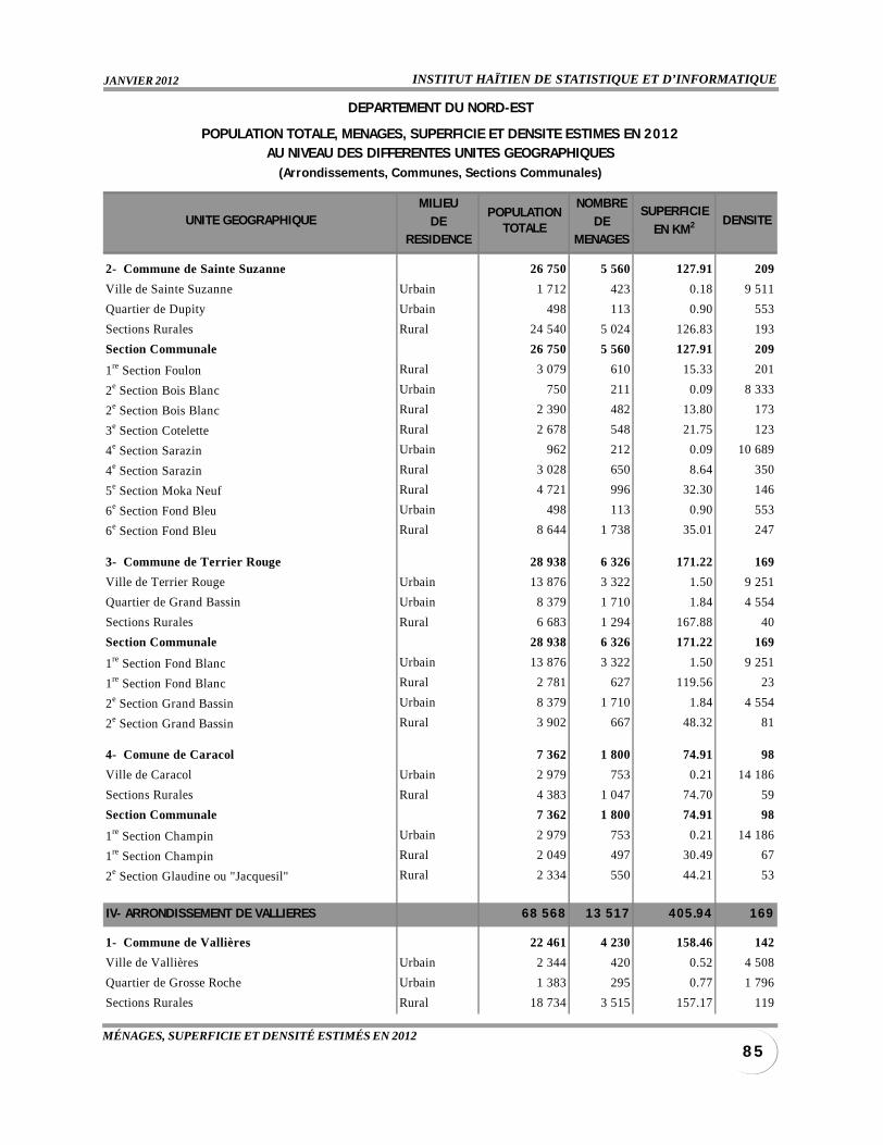
INSTITUT HAÏTIEN DE STATISTIQUE ET D’INFORMATIQUEJANVIER 2012
8 5MÉNAGES, SUPERFICIE ET DENSITÉ ESTIMÉS EN 2012
MILIEU NOMBRE
DE DERESIDENCE MENAGES
2- Commune de Sainte Suzanne 26 750 5 560 127.91 209
Ville de Sainte Suzanne Urbain 1 712 423 0.18 9 511
Quartier de Dupity Urbain 498 113 0.90 553
Sections Rurales Rural 24 540 5 024 126.83 193
Section Communale 26 750 5 560 127.91 209
1re Section Foulon Rural 3 079 610 15.33 201
2e Section Bois Blanc Urbain 750 211 0.09 8 333
2e Section Bois Blanc Rural 2 390 482 13.80 173
3e Section Cotelette Rural 2 678 548 21.75 123
4e Section Sarazin Urbain 962 212 0.09 10 689
4e Section Sarazin Rural 3 028 650 8.64 350
5e Section Moka Neuf Rural 4 721 996 32.30 146
6e Section Fond Bleu Urbain 498 113 0.90 553
6e Section Fond Bleu Rural 8 644 1 738 35.01 247
3- Commune de Terrier Rouge 28 938 6 326 171.22 169
Ville de Terrier Rouge Urbain 13 876 3 322 1.50 9 251
Quartier de Grand Bassin Urbain 8 379 1 710 1.84 4 554
Sections Rurales Rural 6 683 1 294 167.88 40
Section Communale 28 938 6 326 171.22 169
1re Section Fond Blanc Urbain 13 876 3 322 1.50 9 251
1re Section Fond Blanc Rural 2 781 627 119.56 23
2e Section Grand Bassin Urbain 8 379 1 710 1.84 4 554
2e Section Grand Bassin Rural 3 902 667 48.32 81
4- Comune de Caracol 7 362 1 800 74.91 98
Ville de Caracol Urbain 2 979 753 0.21 14 186
Sections Rurales Rural 4 383 1 047 74.70 59
Section Communale 7 362 1 800 74.91 98
1re Section Champin Urbain 2 979 753 0.21 14 186
1re Section Champin Rural 2 049 497 30.49 67
2e Section Glaudine ou "Jacquesil" Rural 2 334 550 44.21 53
IV- ARRONDISSEMENT DE VALLIERES 68 568 13 517 405.94 169
1- Commune de Vallières 22 461 4 230 158.46 142
Ville de Vallières Urbain 2 344 420 0.52 4 508
Quartier de Grosse Roche Urbain 1 383 295 0.77 1 796
Sections Rurales Rural 18 734 3 515 157.17 119
POPULATIONTOTALE
SUPERFICIE
EN KM2
DEPARTEMENT DU NORD-EST
POPULATION TOTALE, MENAGES, SUPERFICIE ET DENSITE ESTIMES EN 2012AU NIVEAU DES DIFFERENTES UNITES GEOGRAPHIQUES
(Arrondissements, Communes, Sections Communales)
UNITE GEOGRAPHIQUE DENSITE
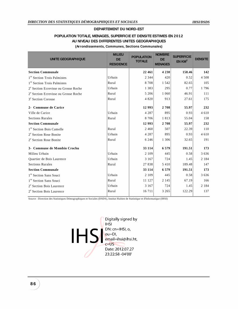
IHSI/DSDSDIRECTION DES STATISTIQUES DÉMOGRAPHIQUES ET SOCIALES
8 6
MILIEU NOMBRE
DE DERESIDENCE MENAGES
Section Communale 22 461 4 230 158.46 142
1re Section Trois Palmistes Urbain 2 344 420 0.52 4 508
1re Section Trois Palmistes Rural 8 708 1 542 82.65 105
2e Section Ecrevisse ou Grosse Roche Urbain 1 383 295 0.77 1 796
2e Section Ecrevisse ou Grosse Roche Rural 5 206 1 060 46.91 111
3e Section Corosse Rural 4 820 913 27.61 175
2- Commune de Carice 12 993 2 708 55.97 232
Ville de Carice Urbain 4 287 895 0.93 4 610
Sections Rurales Rural 8 706 1 813 55.04 158
Section Communale 12 993 2 708 55.97 232
1re Section Bois Camelle Rural 2 460 507 22.39 110
2e Section Rose Bonite Urbain 4 287 895 0.93 4 610
2e Section Rose Bonite Rural 6 246 1 306 32.65 191
3- Commune de Mombin Crochu 33 114 6 579 191.51 173
Milieu Urbain Urbain 2 109 445 0.58 3 636
Quartier de Bois Laurence Urbain 3 167 724 1.45 2 184
Sections Rurales Rural 27 838 5 410 189.48 147
Section Communale 33 114 6 579 191.51 173
1re Section Sans Souci Urbain 2 109 445 0.58 3 636
1re Section Sans Souci Rural 11 127 2 145 67.19 166
2e Section Bois Laurence Urbain 3 167 724 1.45 2 184
2e Section Bois Laurence Rural 16 711 3 265 122.29 137
Source : Direction des Statistiques Démographiques et Sociales (DSDS), Institut Haïtien de Statistique et d'Informatique (IHSI)
POPULATIONTOTALE
SUPERFICIE
EN KM2
DEPARTEMENT DU NORD-EST
POPULATION TOTALE, MENAGES, SUPERFICIE ET DENSITE ESTIMES EN 2012AU NIVEAU DES DIFFERENTES UNITES GEOGRAPHIQUES
(Arrondissements , Communes, Sect ions Communales)
UNITE GEOGRAPHIQUE DENSITE
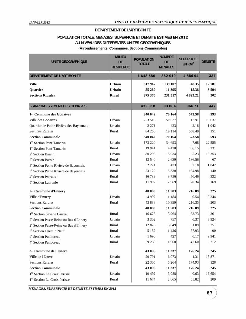
INSTITUT HAÏTIEN DE STATISTIQUE ET D’INFORMATIQUEJANVIER 2012
8 7MÉNAGES, SUPERFICIE ET DENSITÉ ESTIMÉS EN 2012
MILIEU NOMBRE
DE DERESIDENCE MENAGES
DEPARTEMENT DE L'ARTIBONITE 1 648 586 382 019 4 886.94 337
Ville Urbain 617 947 139 107 48.35 12 781
Quartier Urbain 55 269 11 395 15.38 3 594
Sections Rurales Rural 975 370 231 517 4 823.21 202
I- ARRONDISSEMENT DES GONAIVES 432 018 93 084 966.71 447
1- Commune des Gonaïves 340 042 70 164 573.58 593
Ville des Gonaïves Urbain 253 515 50 627 12.91 19 637
Quartier de Petite Rivière des Bayonnais Urbain 2 271 423 2.18 1 042
Sections Rurales Rural 84 256 19 114 558.49 151
Section Communale 340 042 70 164 573.58 593
1re Section Pont Tamarin Urbain 173 220 34 693 7.68 22 555
1re Section Pont Tamarin Rural 19 941 4 420 86.15 231
2e Section Bassin Urbain 80 295 15 934 5.23 15 353
2e Section Bassin Rural 12 540 2 639 186.56 67
3e Section Petite Rivière de Bayonnais Urbain 2 271 423 2.18 1 042
3e Section Petite Rivière de Bayonnais Rural 23 129 5 330 164.98 140
4e Section Poteaux Rural 16 739 3 756 50.46 332
5e Section Labranle Rural 11 907 2 969 70.34 169
2- Commune d'Ennery 48 880 11 583 216.89 225
Ville d'Ennery Urbain 4 992 1 184 0.54 9 244
Sections Rurales Rural 43 888 10 399 216.35 203
Section Communale 48 880 11 583 216.89 225
1re Section Savane Carrée Rural 16 626 3 964 63.73 261
2e Section Passe-Reine ou Bas d'Ennery Urbain 3 302 757 0.37 8 924
2e Section Passe-Reine ou Bas d'Ennery Rural 12 823 3 049 51.09 251
3e Section Chemin Neuf Rural 5 189 1 426 57.93 90
4e Section Puilboreau Urbain 1 690 427 0.17 9 941
4e Section Puilboreau Rural 9 250 1 960 43.60 212
3- Commune de l'Estère 43 096 11 337 176.24 245
Ville de l'Estère Urbain 20 791 6 073 1.31 15 871
Sections Rurales Rural 22 305 5 264 174.93 128
Section Communale 43 096 11 337 176.24 245
1re Section La Croix Perisse Urbain 10 492 3 088 0.63 16 654
1re Section La Croix Perisse Rural 11 674 2 865 55.82 209
POPULATIONTOTALE
SUPERFICIE
EN KM2
DEPARTEMENT DE L'ARTIBONITE
POPULATION TOTALE, MENAGES, SUPERFICIE ET DENSITE ESTIMES EN 2012AU NIVEAU DES DIFFERENTES UNITES GEOGRAPHIQUES
(Arrondissements, Communes, Sections Communales)
UNITE GEOGRAPHIQUE DENSITE
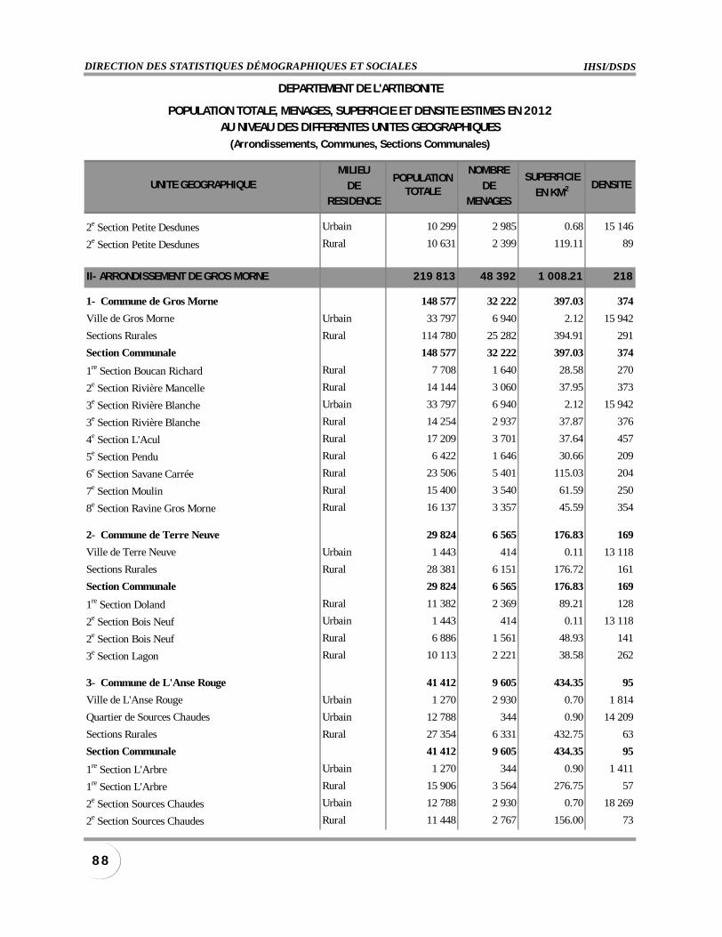
IHSI/DSDSDIRECTION DES STATISTIQUES DÉMOGRAPHIQUES ET SOCIALES
8 8
MILIEU NOMBRE
DE DERESIDENCE MENAGES
2e Section Petite Desdunes Urbain 10 299 2 985 0.68 15 146
2e Section Petite Desdunes Rural 10 631 2 399 119.11 89
II- ARRONDISSEMENT DE GROS MORNE 219 813 48 392 1 008.21 218
1- Commune de Gros Morne 148 577 32 222 397.03 374
Ville de Gros Morne Urbain 33 797 6 940 2.12 15 942
Sections Rurales Rural 114 780 25 282 394.91 291
Section Communale 148 577 32 222 397.03 374
1re Section Boucan Richard Rural 7 708 1 640 28.58 270
2e Section Rivière Mancelle Rural 14 144 3 060 37.95 373
3e Section Rivière Blanche Urbain 33 797 6 940 2.12 15 942
3e Section Rivière Blanche Rural 14 254 2 937 37.87 376
4e Section L'Acul Rural 17 209 3 701 37.64 457
5e Section Pendu Rural 6 422 1 646 30.66 209
6e Section Savane Carrée Rural 23 506 5 401 115.03 204
7e Section Moulin Rural 15 400 3 540 61.59 250
8e Section Ravine Gros Morne Rural 16 137 3 357 45.59 354
2- Commune de Terre Neuve 29 824 6 565 176.83 169
Ville de Terre Neuve Urbain 1 443 414 0.11 13 118
Sections Rurales Rural 28 381 6 151 176.72 161
Section Communale 29 824 6 565 176.83 169
1re Section Doland Rural 11 382 2 369 89.21 128
2e Section Bois Neuf Urbain 1 443 414 0.11 13 118
2e Section Bois Neuf Rural 6 886 1 561 48.93 141
3e Section Lagon Rural 10 113 2 221 38.58 262
3- Commune de L'Anse Rouge 41 412 9 605 434.35 95
Ville de L'Anse Rouge Urbain 1 270 2 930 0.70 1 814
Quartier de Sources Chaudes Urbain 12 788 344 0.90 14 209
Sections Rurales Rural 27 354 6 331 432.75 63
Section Communale 41 412 9 605 434.35 95
1re Section L'Arbre Urbain 1 270 344 0.90 1 411
1re Section L'Arbre Rural 15 906 3 564 276.75 57
2e Section Sources Chaudes Urbain 12 788 2 930 0.70 18 269
2e Section Sources Chaudes Rural 11 448 2 767 156.00 73
POPULATIONTOTALE
SUPERFICIE
EN KM2
DEPARTEMENT DE L'ARTIBONITE
POPULATION TOTALE, MENAGES, SUPERFICIE ET DENSITE ESTIMES EN 2012AU NIVEAU DES DIFFERENTES UNITES GEOGRAPHIQUES
(Arrondissements, Communes, Sections Communales)
UNITE GEOGRAPHIQUE DENSITE
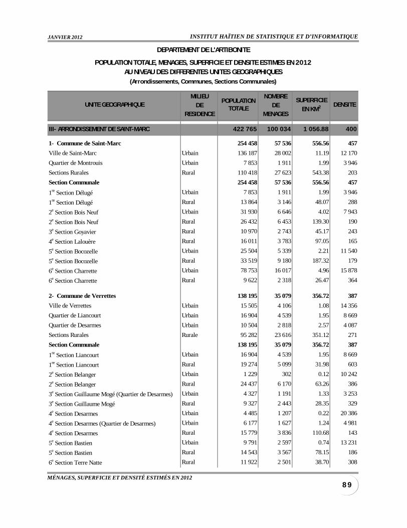
INSTITUT HAÏTIEN DE STATISTIQUE ET D’INFORMATIQUEJANVIER 2012
8 9MÉNAGES, SUPERFICIE ET DENSITÉ ESTIMÉS EN 2012
MILIEU NOMBRE
DE DERESIDENCE MENAGES
III- ARRONDISSEMENT DE SAINT-MARC 422 765 100 034 1 056.88 400
1- Commune de Saint-Marc 254 458 57 536 556.56 457
Ville de Saint-Marc Urbain 136 187 28 002 11.19 12 170
Quartier de Montrouis Urbain 7 853 1 911 1.99 3 946
Sections Rurales Rural 110 418 27 623 543.38 203
Section Communale 254 458 57 536 556.56 457
1re Section Délugé Urbain 7 853 1 911 1.99 3 946
1re Section Délugé Rural 13 864 3 146 48.07 288
2e Section Bois Neuf Urbain 31 930 6 646 4.02 7 943
2e Section Bois Neuf Rural 26 432 6 453 139.30 190
3e Section Goyavier Rural 10 970 2 743 45.17 243
4e Section Lalouère Rural 16 011 3 783 97.05 165
5e Section Bocozelle Urbain 25 504 5 339 2.21 11 540
5e Section Bocozelle Rural 33 519 9 180 187.32 179
6e Section Charrette Urbain 78 753 16 017 4.96 15 878
6e Section Charrette Rural 9 622 2 318 26.47 364
2- Commune de Verrettes 138 195 35 079 356.72 387
Ville de Verrettes Urbain 15 505 4 106 1.08 14 356
Quartier de Liancourt Urbain 16 904 4 539 1.95 8 669
Quartier de Desarmes Urbain 10 504 2 818 2.57 4 087
Sections Rurales Rurale 95 282 23 616 351.12 271
Section Communale 138 195 35 079 356.72 387
1re Section Liancourt Urbain 16 904 4 539 1.95 8 669
1re Section Liancourt Rural 19 274 5 099 31.98 603
2e Section Belanger Urbain 1 229 302 0.12 10 242
2e Section Belanger Rural 24 437 6 170 63.26 386
3e Section Guillaume Mogé (Quartier de Desarmes) Urbain 4 327 1 191 1.33 3 253
3e Section Guillaume Mogé Rural 9 327 2 443 28.35 329
4e Section Desarmes Urbain 4 485 1 207 0.22 20 386
4e Section Desarmes (Quartier de Desarmes) Urbain 6 177 1 627 1.24 4 981
4e Section Desarmes Rural 15 779 3 836 110.68 143
5e Section Bastien Urbain 9 791 2 597 0.74 13 231
5e Section Bastien Rural 14 543 3 567 78.15 186
6e Section Terre Natte Rural 11 922 2 501 38.70 308
POPULATIONTOTALE
SUPERFICIE
EN KM2
DEPARTEMENT DE L'ARTIBONITE
POPULATION TOTALE, MENAGES, SUPERFICIE ET DENSITE ESTIMES EN 2012AU NIVEAU DES DIFFERENTES UNITES GEOGRAPHIQUES
(Arrondissements, Communes, Sections Communales)
UNITE GEOGRAPHIQUE DENSITE
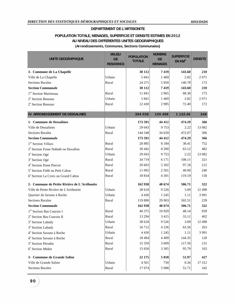
IHSI/DSDSDIRECTION DES STATISTIQUES DÉMOGRAPHIQUES ET SOCIALES
9 0
MILIEU NOMBRE
DE DERESIDENCE MENAGES
3- Commune de La Chapelle 30 112 7 419 143.60 210
Ville de La Chapelle Urbain 5 841 1 469 2.82 2 071
Sections Rurales Rural 24 271 5 950 140.78 172
Section Communale 30 112 7 419 143.60 210
1re Section Martineau Rural 11 841 2 965 68.38 173
2e Section Bossous Urbain 5 841 1 469 2.82 2 071
2e Section Bossous Rural 12 430 2 985 72.40 172
IV- ARRONDISSEMENT DE DESSALINES 394 038 100 498 1 132.46 348
1- Commune de Dessalines 173 591 44 412 474.29 366
Ville de Dessalines Urbain 29 043 9 753 2.22 13 082
Sections Rurales Rural 144 548 34 659 472.07 306
Section Communale 173 591 44 412 474.29 366
1re Section Villars Rural 28 885 8 184 38.41 752
2e Section Fosse Naboth ou Duvallon Rural 30 442 8 200 63.12 482
3e Section Ogé Urbain 29 043 9 753 2.22 13 082
3e Section Ogé Rural 34 719 6 171 108.11 321
4e Section Poste Pierrot Rural 20 603 5 302 97.18 212
5e Section Fiéfé ou Petit Cahos Rural 11 065 2 501 46.06 240
6e Section La Croix ou Grand Cahos Rural 18 834 4 301 119.19 158
2- Commune de Petite Rivière de L'Artibonite 162 938 40 674 506.71 322
Ville de Petite Rivière de L'Artibonite Urbain 38 618 9 526 3.09 12 498
Quartier de Savane à Roche Urbain 4 430 1 245 1.11 3 991
Sections Rurales Rural 119 890 29 903 502.51 239
Section Communale 162 938 40 674 506.71 322
1re Section Bas Coursin I Rural 40 375 10 929 48.14 839
2e Section Bas Coursin II Rural 13 294 3 415 33.11 402
3e Section Labady Urbain 38 618 9 526 3.09 12 498
3e Section Labady Rural 16 712 4 236 63.56 263
4e Section Savane à Roche Urbain 4 430 1 245 1.11 3 991
4e Section Savane à Roche Rural 18 494 4 409 144.35 128
5e Section Pérodin Rural 15 359 3 609 117.56 131
6e Section Médor Rural 15 656 3 305 95.79 163
3- Commune de Grande Saline 22 175 5 818 51.97 427
Ville de Grande Saline Urbain 4 501 730 0.26 17 312
Sections Rurales Rural 17 674 5 088 51.71 342
POPULATIONTOTALE
SUPERFICIE
EN KM2
DEPARTEMENT DE L'ARTIBONITE
POPULATION TOTALE, MENAGES, SUPERFICIE ET DENSITE ESTIMES EN 2012AU NIVEAU DES DIFFERENTES UNITES GEOGRAPHIQUES
(Arrondissements, Communes, Sections Communales)
UNITE GEOGRAPHIQUE DENSITE
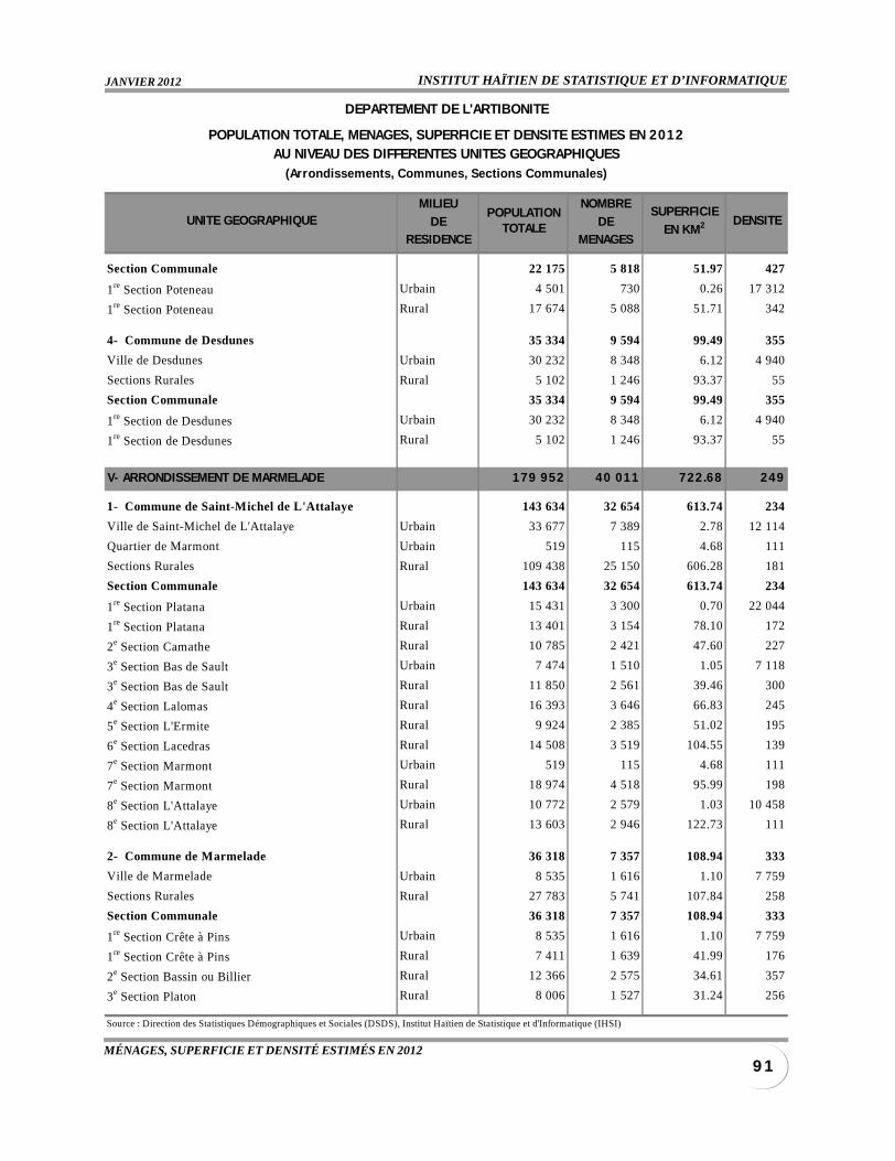
INSTITUT HAÏTIEN DE STATISTIQUE ET D’INFORMATIQUEJANVIER 2012
9 1MÉNAGES, SUPERFICIE ET DENSITÉ ESTIMÉS EN 2012
MILIEU NOMBRE
DE DERESIDENCE MENAGES
Section Communale 22 175 5 818 51.97 427
1re Section Poteneau Urbain 4 501 730 0.26 17 312
1re Section Poteneau Rural 17 674 5 088 51.71 342
4- Commune de Desdunes 35 334 9 594 99.49 355
Ville de Desdunes Urbain 30 232 8 348 6.12 4 940
Sections Rurales Rural 5 102 1 246 93.37 55
Section Communale 35 334 9 594 99.49 355
1re Section de Desdunes Urbain 30 232 8 348 6.12 4 940
1re Section de Desdunes Rural 5 102 1 246 93.37 55
V- ARRONDISSEMENT DE MARMELADE 179 952 40 011 722.68 249
1- Commune de Saint-Michel de L'Attalaye 143 634 32 654 613.74 234
Ville de Saint-Michel de L'Attalaye Urbain 33 677 7 389 2.78 12 114
Quartier de Marmont Urbain 519 115 4.68 111
Sections Rurales Rural 109 438 25 150 606.28 181
Section Communale 143 634 32 654 613.74 234
1re Section Platana Urbain 15 431 3 300 0.70 22 044
1re Section Platana Rural 13 401 3 154 78.10 172
2e Section Camathe Rural 10 785 2 421 47.60 227
3e Section Bas de Sault Urbain 7 474 1 510 1.05 7 118
3e Section Bas de Sault Rural 11 850 2 561 39.46 300
4e Section Lalomas Rural 16 393 3 646 66.83 245
5e Section L'Ermite Rural 9 924 2 385 51.02 195
6e Section Lacedras Rural 14 508 3 519 104.55 139
7e Section Marmont Urbain 519 115 4.68 111
7e Section Marmont Rural 18 974 4 518 95.99 198
8e Section L'Attalaye Urbain 10 772 2 579 1.03 10 458
8e Section L'Attalaye Rural 13 603 2 946 122.73 111
2- Commune de Marmelade 36 318 7 357 108.94 333
Ville de Marmelade Urbain 8 535 1 616 1.10 7 759
Sections Rurales Rural 27 783 5 741 107.84 258
Section Communale 36 318 7 357 108.94 333
1re Section Crête à Pins Urbain 8 535 1 616 1.10 7 759
1re Section Crête à Pins Rural 7 411 1 639 41.99 176
2e Section Bassin ou Billier Rural 12 366 2 575 34.61 357
3e Section Platon Rural 8 006 1 527 31.24 256
Source : Direction des Statistiques Démographiques et Sociales (DSDS), Institut Haïtien de Statistique et d'Informatique (IHSI)
POPULATIONTOTALE
SUPERFICIE
EN KM2
DEPARTEMENT DE L'ARTIBONITE
POPULATION TOTALE, MENAGES, SUPERFICIE ET DENSITE ESTIMES EN 2012AU NIVEAU DES DIFFERENTES UNITES GEOGRAPHIQUES
(Arrondissements, Communes, Sect ions Communales)
UNITE GEOGRAPHIQUE DENSITE
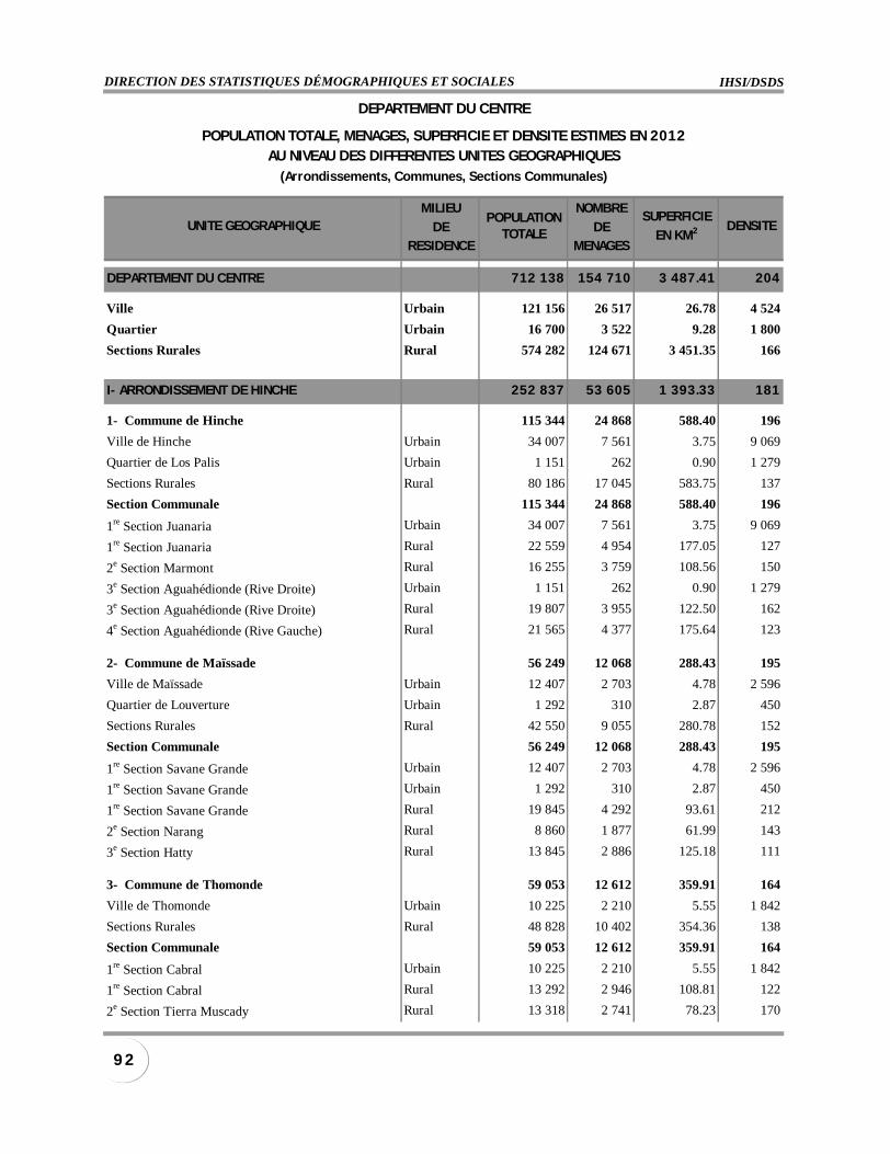
IHSI/DSDSDIRECTION DES STATISTIQUES DÉMOGRAPHIQUES ET SOCIALES
9 2
MILIEU NOMBRE
DE DERESIDENCE MENAGES
DEPARTEMENT DU CENTRE 712 138 154 710 3 487.41 204
Ville Urbain 121 156 26 517 26.78 4 524
Quartier Urbain 16 700 3 522 9.28 1 800
Sections Rurales Rural 574 282 124 671 3 451.35 166
I- ARRONDISSEMENT DE HINCHE 252 837 53 605 1 393.33 181
1- Commune de Hinche 115 344 24 868 588.40 196
Ville de Hinche Urbain 34 007 7 561 3.75 9 069
Quartier de Los Palis Urbain 1 151 262 0.90 1 279
Sections Rurales Rural 80 186 17 045 583.75 137
Section Communale 115 344 24 868 588.40 196
1re Section Juanaria Urbain 34 007 7 561 3.75 9 069
1re Section Juanaria Rural 22 559 4 954 177.05 127
2e Section Marmont Rural 16 255 3 759 108.56 150
3e Section Aguahédionde (Rive Droite) Urbain 1 151 262 0.90 1 279
3e Section Aguahédionde (Rive Droite) Rural 19 807 3 955 122.50 162
4e Section Aguahédionde (Rive Gauche) Rural 21 565 4 377 175.64 123
2- Commune de Maïssade 56 249 12 068 288.43 195
Ville de Maïssade Urbain 12 407 2 703 4.78 2 596
Quartier de Louverture Urbain 1 292 310 2.87 450
Sections Rurales Rural 42 550 9 055 280.78 152
Section Communale 56 249 12 068 288.43 195
1re Section Savane Grande Urbain 12 407 2 703 4.78 2 596
1re Section Savane Grande Urbain 1 292 310 2.87 450
1re Section Savane Grande Rural 19 845 4 292 93.61 212
2e Section Narang Rural 8 860 1 877 61.99 143
3e Section Hatty Rural 13 845 2 886 125.18 111
3- Commune de Thomonde 59 053 12 612 359.91 164
Ville de Thomonde Urbain 10 225 2 210 5.55 1 842
Sections Rurales Rural 48 828 10 402 354.36 138
Section Communale 59 053 12 612 359.91 164
1re Section Cabral Urbain 10 225 2 210 5.55 1 842
1re Section Cabral Rural 13 292 2 946 108.81 122
2e Section Tierra Muscady Rural 13 318 2 741 78.23 170
POPULATIONTOTALE
SUPERFICIE
EN KM2
DEPARTEMENT DU CENTRE
POPULATION TOTALE, MENAGES, SUPERFICIE ET DENSITE ESTIMES EN 2012AU NIVEAU DES DIFFERENTES UNITES GEOGRAPHIQUES
(Arrondissements, Communes, Sections Communales)
UNITE GEOGRAPHIQUE DENSITE
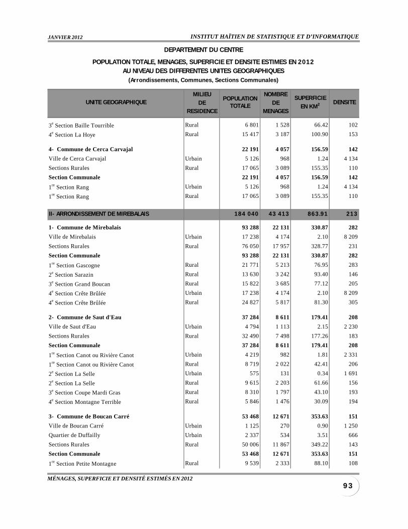
INSTITUT HAÏTIEN DE STATISTIQUE ET D’INFORMATIQUEJANVIER 2012
9 3MÉNAGES, SUPERFICIE ET DENSITÉ ESTIMÉS EN 2012
MILIEU NOMBRE
DE DERESIDENCE MENAGES
3e Section Baille Tourrible Rural 6 801 1 528 66.42 102
4e Section La Hoye Rural 15 417 3 187 100.90 153
4- Commune de Cerca Carvajal 22 191 4 057 156.59 142
Ville de Cerca Carvajal Urbain 5 126 968 1.24 4 134
Sections Rurales Rural 17 065 3 089 155.35 110
Section Communale 22 191 4 057 156.59 142
1re Section Rang Urbain 5 126 968 1.24 4 134
1re Section Rang Rural 17 065 3 089 155.35 110
II- ARRONDISSEMENT DE MIREBALAIS 184 040 43 413 863.91 213
1- Commune de Mirebalais 93 288 22 131 330.87 282
Ville de Mirebalais Urbain 17 238 4 174 2.10 8 209
Sections Rurales Rural 76 050 17 957 328.77 231
Section Communale 93 288 22 131 330.87 282
1re Section Gascogne Rural 21 771 5 213 76.95 283
2e Section Sarazin Rural 13 630 3 242 93.40 146
3e Section Grand Boucan Rural 15 822 3 685 77.12 205
4e Section Crête Brûlée Urbain 17 238 4 174 2.10 8 209
4e Section Crête Brûlée Rural 24 827 5 817 81.30 305
2- Commune de Saut d'Eau 37 284 8 611 179.41 208
Ville de Saut d'Eau Urbain 4 794 1 113 2.15 2 230
Sections Rurales Rural 32 490 7 498 177.26 183
Section Communale 37 284 8 611 179.41 208
1re Section Canot ou Rivière Canot Urbain 4 219 982 1.81 2 331
1re Section Canot ou Rivière Canot Rural 8 719 2 022 42.41 206
2e Section La Selle Urbain 575 131 0.34 1 691
2e Section La Selle Rural 9 615 2 203 61.66 156
3e Section Coupe Mardi Gras Rural 8 310 1 797 43.10 193
4e Section Montagne Terrible Rural 5 846 1 476 30.09 194
3- Commune de Boucan Carré 53 468 12 671 353.63 151
Ville de Boucan Carré Urbain 1 125 270 0.90 1 250
Quartier de Duffailly Urbain 2 337 534 3.51 666
Sections Rurales Rural 50 006 11 867 349.22 143
Section Communale 53 468 12 671 353.63 151
1re Section Petite Montagne Rural 9 539 2 333 88.10 108
POPULATIONTOTALE
SUPERFICIE
EN KM2
DEPARTEMENT DU CENTRE
POPULATION TOTALE, MENAGES, SUPERFICIE ET DENSITE ESTIMES EN 2012AU NIVEAU DES DIFFERENTES UNITES GEOGRAPHIQUES
(Arrondissements, Communes, Sections Communales)
UNITE GEOGRAPHIQUE DENSITE
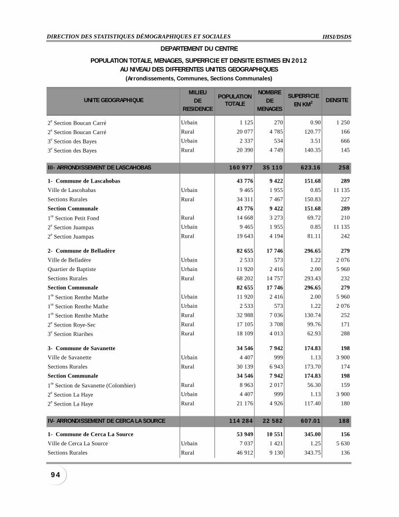
IHSI/DSDSDIRECTION DES STATISTIQUES DÉMOGRAPHIQUES ET SOCIALES
9 4
MILIEU NOMBRE
DE DERESIDENCE MENAGES
2e Section Boucan Carré Urbain 1 125 270 0.90 1 250
2e Section Boucan Carré Rural 20 077 4 785 120.77 166
3e Section des Bayes Urbain 2 337 534 3.51 666
3e Section des Bayes Rural 20 390 4 749 140.35 145
III- ARRONDISSEMENT DE LASCAHOBAS 160 977 35 110 623.16 258
1- Commune de Lascahobas 43 776 9 422 151.68 289
Ville de Lascohabas Urbain 9 465 1 955 0.85 11 135
Sections Rurales Rural 34 311 7 467 150.83 227
Section Communale 43 776 9 422 151.68 289
1re Section Petit Fond Rural 14 668 3 273 69.72 210
2e Section Juampas Urbain 9 465 1 955 0.85 11 135
2e Section Juampas Rural 19 643 4 194 81.11 242
2- Commune de Belladère 82 655 17 746 296.65 279
Ville de Belladère Urbain 2 533 573 1.22 2 076
Quartier de Baptiste Urbain 11 920 2 416 2.00 5 960
Sections Rurales Rural 68 202 14 757 293.43 232
Section Communale 82 655 17 746 296.65 279
1re Section Renthe Mathe Urbain 11 920 2 416 2.00 5 960
1re Section Renthe Mathe Urbain 2 533 573 1.22 2 076
1re Section Renthe Mathe Rural 32 988 7 036 130.74 252
2e Section Roye-Sec Rural 17 105 3 708 99.76 171
3e Section Riaribes Rural 18 109 4 013 62.93 288
3- Commune de Savanette 34 546 7 942 174.83 198
Ville de Savanette Urbain 4 407 999 1.13 3 900
Sections Rurales Rural 30 139 6 943 173.70 174
Section Communale 34 546 7 942 174.83 198
1re Section de Savanette (Colombier) Rural 8 963 2 017 56.30 159
2e Section La Haye Urbain 4 407 999 1.13 3 900
2e Section La Haye Rural 21 176 4 926 117.40 180
IV- ARRONDISSEMENT DE CERCA LA SOURCE 114 284 22 582 607.01 188
1- Commune de Cerca La Source 53 949 10 551 345.00 156
Ville de Cerca La Source Urbain 7 037 1 421 1.25 5 630
Sections Rurales Rural 46 912 9 130 343.75 136
POPULATIONTOTALE
SUPERFICIE
EN KM2
DEPARTEMENT DU CENTRE
POPULATION TOTALE, MENAGES, SUPERFICIE ET DENSITE ESTIMES EN 2012AU NIVEAU DES DIFFERENTES UNITES GEOGRAPHIQUES
(Arrondissements, Communes, Sections Communales)
UNITE GEOGRAPHIQUE DENSITE
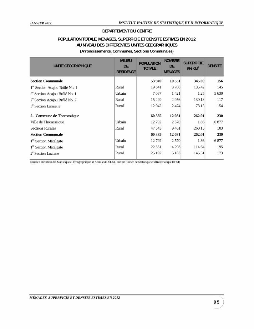
INSTITUT HAÏTIEN DE STATISTIQUE ET D’INFORMATIQUEJANVIER 2012
9 5MÉNAGES, SUPERFICIE ET DENSITÉ ESTIMÉS EN 2012
MILIEU NOMBRE
DE DERESIDENCE MENAGES
Section Communale 53 949 10 551 345.00 156
1re Section Acajou Brûlé No. 1 Rural 19 641 3 700 135.42 145
2e Section Acajou Brûlé No. 1 Urbain 7 037 1 421 1.25 5 630
2e Section Acajou Brûlé No. 2 Rural 15 229 2 956 130.18 117
3e Section Lamielle Rural 12 042 2 474 78.15 154
2- Commune de Thomassique 60 335 12 031 262.01 230
Ville de Thomassique Urbain 12 792 2 570 1.86 6 877
Sections Rurales Rural 47 543 9 461 260.15 183
Section Communale 60 335 12 031 262.01 230
1re Section Matelgate Urbain 12 792 2 570 1.86 6 877
1re Section Matelgate Rural 22 351 4 298 114.64 195
2e Section Lociane Rural 25 192 5 163 145.51 173
Source : Direction des Statistiques Démographiques et Sociales (DSDS), Institut Haïtien de Statistique et d'Informatique (IHSI)
POPULATIONTOTALE
SUPERFICIE
EN KM2
DEPARTEMENT DU CENTRE
POPULATION TOTALE, MENAGES, SUPERFICIE ET DENSITE ESTIMES EN 2012AU NIVEAU DES DIFFERENTES UNITES GEOGRAPHIQUES
(Arrondissements, Communes, Sections Communales)
UNITE GEOGRAPHIQUE DENSITE
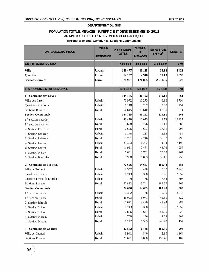
IHSI/DSDSDIRECTION DES STATISTIQUES DÉMOGRAPHIQUES ET SOCIALES
9 6
MILIEU NOMBRE
DE DERESIDENCE MENAGES
DEPARTEMENT DU SUD 739 565 153 888 2 653.60 279
Ville Urbain 146 477 30 115 33.12 4 423
Quartier Urbain 14 127 2 918 10.13 1 395
Sections Rurales Rural 578 961 120 855 2 610.35 222
I- ARRONDISSEMENT DES CAYES 330 454 68 094 873.49 378
1- Commune des Cayes 144 765 30 122 219.11 661
Ville des Cayes Urbain 78 972 16 275 8.98 8 794
Quartier de Laborde Urbain 1 148 237 2.53 454
Sections Rurales Rural 64 645 13 610 207.60 311
Section Communale 144 765 30 122 219.11 661
1re Section Bourdet Urbain 48 478 10 073 4.74 10 227
1re Section Bourdet Rural 18 638 3 726 27.19 685
2e Section Fonfrède Rural 7 606 1 603 37.51 203
3e Section Laborde Urbain 1 148 237 2.53 454
3e Section Laborde Rural 10 731 2 246 36.02 298
4e Section Laurent Urbain 30 494 6 202 4.24 7 192
4e Section Laurent Rural 11 021 2 451 43.03 256
5e Section Mercy Rural 7 661 1 731 28.68 267
6e Section Boulmier Rural 8 988 1 853 35.17 256
2- Commune de Torbeck 72 606 14 683 189.48 383
Ville de Torbeck Urbain 2 352 448 0.80 2 940
Quartier de Ducis Urbain 1 713 358 0.67 2 557
Quartier Ferme de Le Blanc Urbain 709 136 2.34 303
Sections Rurales Rural 67 832 13 741 185.67 365
Section Communale 72 606 14 683 189.48 383
1re Section Boury Urbain 2 352 448 0.80 2 940
1re Section Boury Rural 26 003 5 071 41.81 622
2e Section Bérault Rural 17 671 3 490 45.94 385
3e Section Solon Urbain 1 713 358 0.67 2 557
3e Section Solon Rural 16 886 3 647 51.50 328
4e Section Moreau Urbain 709 136 2.34 303
4e Section Moreau Rural 7 272 1 533 46.42 157
3- Commune de Chantal 32 562 6 738 160.36 203
Ville de Chantal Urbain 3 941 840 2.89 1 364
Sections Rurales Rural 28 621 5 898 157.47 182
POPULATIONTOTALE
SUPERFICIE
EN KM2
DEPARTEMENT DU SUD
POPULATION TOTALE, MENAGES, SUPERFICIE ET DENSITE ESTIMES EN 2012AU NIVEAU DES DIFFERENTES UNITES GEOGRAPHIQUES
(Arrondissements, Communes, Sections Communales)
UNITE GEOGRAPHIQUE DENSITE
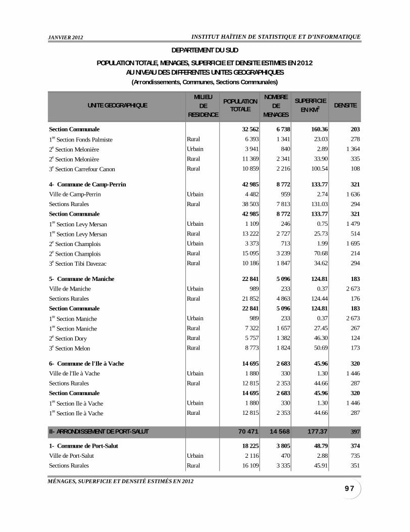
INSTITUT HAÏTIEN DE STATISTIQUE ET D’INFORMATIQUEJANVIER 2012
9 7MÉNAGES, SUPERFICIE ET DENSITÉ ESTIMÉS EN 2012
MILIEU NOMBRE
DE DERESIDENCE MENAGES
Section Communale 32 562 6 738 160.36 203
1re Section Fonds Palmiste Rural 6 393 1 341 23.03 278
2e Section Melonière Urbain 3 941 840 2.89 1 364
2e Section Melonière Rural 11 369 2 341 33.90 335
3e Section Carrefour Canon Rural 10 859 2 216 100.54 108
4- Commune de Camp-Perrin 42 985 8 772 133.77 321
Ville de Camp-Perrin Urbain 4 482 959 2.74 1 636
Sections Rurales Rural 38 503 7 813 131.03 294
Section Communale 42 985 8 772 133.77 321
1re Section Levy Mersan Urbain 1 109 246 0.75 1 479
1re Section Levy Mersan Rural 13 222 2 727 25.73 514
2e Section Champlois Urbain 3 373 713 1.99 1 695
2e Section Champlois Rural 15 095 3 239 70.68 214
3e Section Tibi Davezac Rural 10 186 1 847 34.62 294
5- Commune de Maniche 22 841 5 096 124.81 183
Ville de Maniche Urbain 989 233 0.37 2 673
Sections Rurales Rural 21 852 4 863 124.44 176
Section Communale 22 841 5 096 124.81 183
1re Section Maniche Urbain 989 233 0.37 2 673
1re Section Maniche Rural 7 322 1 657 27.45 267
2e Section Dory Rural 5 757 1 382 46.30 124
3e Section Melon Rural 8 773 1 824 50.69 173
6- Commune de l'Ile à Vache 14 695 2 683 45.96 320
Ville de l'Ile à Vache Urbain 1 880 330 1.30 1 446
Sections Rurales Rural 12 815 2 353 44.66 287
Section Communale 14 695 2 683 45.96 320
1re Section Ile à Vache Urbain 1 880 330 1.30 1 446
1re Section Ile à Vache Rural 12 815 2 353 44.66 287
II- ARRONDISSEMENT DE PORT-SALUT 70 471 14 568 177.37 397
1- Commune de Port-Salut 18 225 3 805 48.79 374
Ville de Port-Salut Urbain 2 116 470 2.88 735
Sections Rurales Rural 16 109 3 335 45.91 351
POPULATIONTOTALE
SUPERFICIE
EN KM2
DEPARTEMENT DU SUD
POPULATION TOTALE, MENAGES, SUPERFICIE ET DENSITE ESTIMES EN 2012AU NIVEAU DES DIFFERENTES UNITES GEOGRAPHIQUES
(Arrondissements, Communes, Sections Communales)
UNITE GEOGRAPHIQUE DENSITE
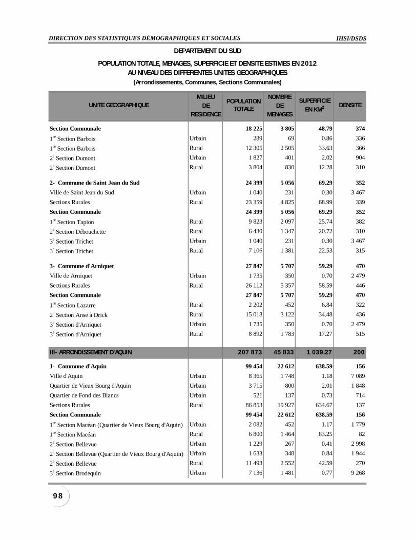
IHSI/DSDSDIRECTION DES STATISTIQUES DÉMOGRAPHIQUES ET SOCIALES
9 8
MILIEU NOMBRE
DE DERESIDENCE MENAGES
Section Communale 18 225 3 805 48.79 374
1re Section Barbois Urbain 289 69 0.86 336
1re Section Barbois Rural 12 305 2 505 33.63 366
2e Section Dumont Urbain 1 827 401 2.02 904
2e Section Dumont Rural 3 804 830 12.28 310
2- Commune de Saint Jean du Sud 24 399 5 056 69.29 352
Ville de Saint Jean du Sud Urbain 1 040 231 0.30 3 467
Sections Rurales Rural 23 359 4 825 68.99 339
Section Communale 24 399 5 056 69.29 352
1re Section Tapion Rural 9 823 2 097 25.74 382
2e Section Débouchette Rural 6 430 1 347 20.72 310
3e Section Trichet Urbain 1 040 231 0.30 3 467
3e Section Trichet Rural 7 106 1 381 22.53 315
3- Commune d'Arniquet 27 847 5 707 59.29 470
Ville de Arniquet Urbain 1 735 350 0.70 2 479
Sections Rurales Rural 26 112 5 357 58.59 446
Section Communale 27 847 5 707 59.29 470
1re Section Lazarre Rural 2 202 452 6.84 322
2e Section Anse à Drick Rural 15 018 3 122 34.48 436
3e Section d'Arniquet Urbain 1 735 350 0.70 2 479
3e Section d'Arniquet Rural 8 892 1 783 17.27 515
III- ARRONDISSEMENT D'AQUIN 207 873 45 833 1 039.27 200
1- Commune d'Aquin 99 454 22 612 638.59 156
Ville d'Aquin Urbain 8 365 1 748 1.18 7 089
Quartier de Vieux Bourg d'Aquin Urbain 3 715 800 2.01 1 848
Quartier de Fond des Blancs Urbain 521 137 0.73 714
Sections Rurales Rural 86 853 19 927 634.67 137
Section Communale 99 454 22 612 638.59 156
1re Section Macéan (Quartier de Vieux Bourg d'Aquin) Urbain 2 082 452 1.17 1 779
1re Section Macéan Rural 6 800 1 464 83.25 82
2e Section Bellevue Urbain 1 229 267 0.41 2 998
2e Section Bellevue (Quartier de Vieux Bourg d'Aquin) Urbain 1 633 348 0.84 1 944
2e Section Bellevue Rural 11 493 2 552 42.59 270
3e Section Brodequin Urbain 7 136 1 481 0.77 9 268
POPULATIONTOTALE
SUPERFICIE
EN KM2
DEPARTEMENT DU SUD
POPULATION TOTALE, MENAGES, SUPERFICIE ET DENSITE ESTIMES EN 2012AU NIVEAU DES DIFFERENTES UNITES GEOGRAPHIQUES
(Arrondissements, Communes, Sections Communales)
UNITE GEOGRAPHIQUE DENSITE

INSTITUT HAÏTIEN DE STATISTIQUE ET D’INFORMATIQUEJANVIER 2012
9 9MÉNAGES, SUPERFICIE ET DENSITÉ ESTIMÉS EN 2012
MILIEU NOMBRE
DE DERESIDENCE MENAGES
3e Section Brodequin Rural 6 045 1 271 36.94 164
4e Section Flamands Rural 5 711 1 362 131.94 43
5e Section Mare à Coiffe Rural 7 378 1 523 27.59 267
6e Section La Colline Rural 15 473 3 744 71.81 215
7e Section Frangipane Rural 10 755 2 664 127.54 84
8e Section Colline à Mongons Rural 6 993 1 508 29.90 234
9e Section Fond des Blancs Urbain 521 137 0.73 714
9e Section Fond des Blancs Rural 6 966 1 604 45.99 151
10e Section Guirand Rural 9 239 2 235 37.12 249
2- Commune de Saint Louis du Sud 61 957 12 369 185.71 334
Ville de Saint Louis du Sud Urbain 3 026 607 0.64 4 728
Sections Rurales Rural 58 931 11 762 185.07 318
Section Communale 61 957 12 369 185.71 334
1re Section Grand Fonds Rural 2 674 496 21.65 124
2e Section Baie Dumesle Urbain 3 026 607 0.64 4 728
2e Section Baie Dumesle Rural 12 739 2 470 28.96 440
3e Section Grenodière Rural 12 062 2 476 24.89 485
4e Section Zanglais Rural 8 438 1 777 26.09 323
5e Section Sucrerie Henri Rural 4 909 975 15.83 310
6e Section Solon Rural 7 781 1 617 21.36 364
7e Section Cherette Rural 5 371 1 046 23.62 227
8e Section Corail-Henri Rural 4 957 905 22.67 219
3- Commune de Cavaillon 46 462 10 852 214.97 216
Ville de Cavaillon Urbain 2 070 476 0.48 4 313
Sections Rurales Rural 44 392 10 376 214.49 207
Section Communale 46 462 10 852 214.97 216
1re Section Boileau Rural 15 881 3 479 62.26 255
2e Section Martineau Urbain 2 070 476 0.48 4 313
2e Section Martineau Rural 10 848 2 566 55.27 196
3e Section Gros Marin Rural 6 301 1 572 37.25 169
4e Section Mare Henri Rural 7 846 1 893 39.13 201
5e Section Laroque Rural 3 516 866 20.58 171
IV- ARRONDISSEMENT DES COTEAUX 55 939 11 208 181.18 309
1- Commune des Côteaux 20 329 4 229 74.36 273
Ville des Côteaux Urbain 4 304 941 1.03 4 179
Quartier de Damassin Urbain 1 968 455 0.48 4 100
POPULATIONTOTALE
SUPERFICIE
EN KM2
DEPARTEMENT DU SUD
POPULATION TOTALE, MENAGES, SUPERFICIE ET DENSITE ESTIMES EN 2012AU NIVEAU DES DIFFERENTES UNITES GEOGRAPHIQUES
(Arrondissements, Communes, Sections Communales)
UNITE GEOGRAPHIQUE DENSITE
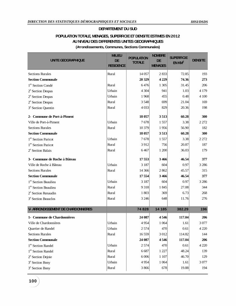
IHSI/DSDSDIRECTION DES STATISTIQUES DÉMOGRAPHIQUES ET SOCIALES
100
MILIEU NOMBRE
DE DERESIDENCE MENAGES
Sections Rurales Rural 14 057 2 833 72.85 193
Section Communale 20 329 4 229 74.36 273
1re Section Condé Rural 6 476 1 305 31.45 206
2e Section Despas Urbain 4 304 941 1.03 4 179
2e Section Despas Urbain 1 968 455 0.48 4 100
2e Section Despas Rural 3 548 699 21.04 169
3e Section Quentin Rural 4 033 829 20.36 198
2- Commune de Port-à-Piment 18 057 3 513 60.28 300
Ville de Port-à-Piment Urbain 7 678 1 557 3.38 2 272
Sections Rurales Rural 10 379 1 956 56.90 182
Section Communale 18 057 3 513 60.28 300
1re Section Paricot Urbain 7 678 1 557 3.38 2 272
1re Section Paricot Rural 3 912 756 20.87 187
2e Section Balais Rural 6 467 1 200 36.03 179
3- Commune de Roche à Bâteau 17 553 3 466 46.54 377
Ville de Roche à Bâteau Urbain 3 187 604 0.97 3 286
Sections Rurales Rural 14 366 2 862 45.57 315
Section Communale 17 554 3 466 46.54 377
1re Section Beaulieu Urbain 3 187 604 0.97 3 286
1re Section Beaulieu Rural 9 318 1 845 27.08 344
2e Section Renaudin Rural 1 803 369 6.73 268
3e Section Beauclos Rural 3 246 648 11.76 276
V- ARRONDISSEMENT DE CHARDONNIERES 74 828 14 185 382.29 196
1- Commune de Chardonnières 24 087 4 546 117.04 206
Ville de Chardonnières Urbain 4 954 1 064 1.61 3 077
Quartier de Randel Urbain 2 574 470 0.61 4 220
Sections Rurales Rural 16 559 3 012 114.82 144
Section Communale 24 087 4 546 117.04 206
1re Section Randel Urbain 2 574 470 0.61 4 220
1re Section Randel Rural 6 687 1 227 48.24 139
2e Section Dejoie Rural 6 006 1 107 46.70 129
3e Section Bony Urbain 4 954 1 064 1.61 3 077
3e Section Bony Rural 3 866 678 19.88 194
POPULATIONTOTALE
SUPERFICIE
EN KM2
DEPARTEMENT DU SUD
POPULATION TOTALE, MENAGES, SUPERFICIE ET DENSITE ESTIMES EN 2012AU NIVEAU DES DIFFERENTES UNITES GEOGRAPHIQUES
(Arrondissements, Communes, Sections Communales)
UNITE GEOGRAPHIQUE DENSITE
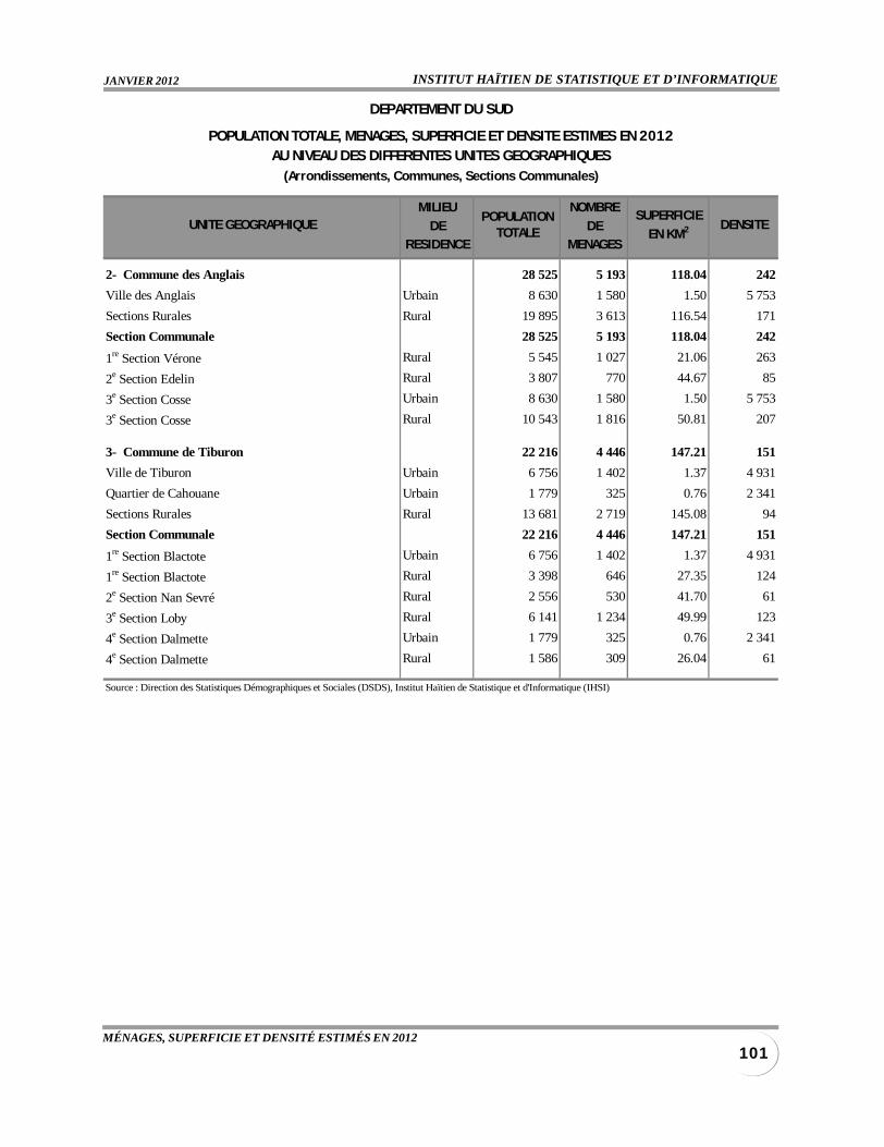
INSTITUT HAÏTIEN DE STATISTIQUE ET D’INFORMATIQUEJANVIER 2012
101MÉNAGES, SUPERFICIE ET DENSITÉ ESTIMÉS EN 2012
MILIEU NOMBRE
DE DERESIDENCE MENAGES
2- Commune des Anglais 28 525 5 193 118.04 242
Ville des Anglais Urbain 8 630 1 580 1.50 5 753
Sections Rurales Rural 19 895 3 613 116.54 171
Section Communale 28 525 5 193 118.04 242
1re Section Vérone Rural 5 545 1 027 21.06 263
2e Section Edelin Rural 3 807 770 44.67 85
3e Section Cosse Urbain 8 630 1 580 1.50 5 753
3e Section Cosse Rural 10 543 1 816 50.81 207
3- Commune de Tiburon 22 216 4 446 147.21 151
Ville de Tiburon Urbain 6 756 1 402 1.37 4 931
Quartier de Cahouane Urbain 1 779 325 0.76 2 341
Sections Rurales Rural 13 681 2 719 145.08 94
Section Communale 22 216 4 446 147.21 151
1re Section Blactote Urbain 6 756 1 402 1.37 4 931
1re Section Blactote Rural 3 398 646 27.35 124
2e Section Nan Sevré Rural 2 556 530 41.70 61
3e Section Loby Rural 6 141 1 234 49.99 123
4e Section Dalmette Urbain 1 779 325 0.76 2 341
4e Section Dalmette Rural 1 586 309 26.04 61
Source : Direction des Statistiques Démographiques et Sociales (DSDS), Institut Haïtien de Statistique et d'Informatique (IHSI)
POPULATIONTOTALE
SUPERFICIE
EN KM2
DEPARTEMENT DU SUD
POPULATION TOTALE, MENAGES, SUPERFICIE ET DENSITE ESTIMES EN 2012AU NIVEAU DES DIFFERENTES UNITES GEOGRAPHIQUES
(Arrondissements, Communes, Sections Communales)
UNITE GEOGRAPHIQUE DENSITE
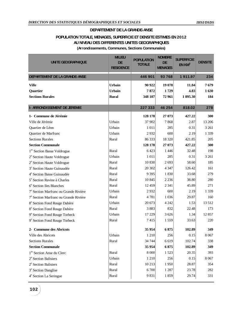
IHSI/DSDSDIRECTION DES STATISTIQUES DÉMOGRAPHIQUES ET SOCIALES
102
MILIEU NOMBRE
DE DERESIDENCE MENAGES
DEPARTEMENT DE LA GRANDE-ANSE 446 901 93 768 1 911.97 234
Ville Urbain 90 922 19 078 11.84 7 679
Quartier Urbain 7 872 1 729 4.83 1 630
Sections Rurales Rural 348 107 72 961 1 895.30 184
I- ARRONDISSEMENT DE JEREMIE 227 333 46 254 818.02 278
1- Commune de Jérémie 128 178 27 073 427.22 300
Ville de Jérémie Urbain 37 902 7 868 2.87 13 206
Quartier de Léon Urbain 1 011 285 0.31 3 261
Quartier de Marfranc Urbain 2 932 600 2.19 1 339
Sections Rurales Rural 86 333 18 320 421.85 205
Section Communale 128 178 27 073 427.22 300
1re Section Basse Voldrogue Rural 6 423 1 446 32.48 198
2e Section Haute Voldrogue Urbain 1 011 285 0.31 3 261
2e Section Haute Voldrogue Rural 10 830 2 693 58.60 185
3e Section Haute Guinaudée Rural 20 302 4 347 126.42 161
4e Section Basse Guinaudée Rural 9 395 1 830 33.68 279
5e Section Ravine à Charles Rural 10 845 2 236 38.80 280
6e Section Iles Blanches Rural 12 459 2 341 45.89 271
7e Section Marfranc ou Grande Rivière Urbain 2 932 600 2.19 1 339
7e Section Marfranc ou Grande Rivière Rural 4 781 1 036 29.87 160
8e Section Fond Rouge Dahère Urbain 20 673 4 242 1.53 13 512
8e Section Fond Rouge Dahère Rural 3 883 832 22.48 173
9e Section Fond Rouge Torbeck Urbain 17 229 3 626 1.34 12 857
9e Section Fond Rouge Torbeck Rural 7 415 1 559 33.63 220
2- Commune des Abricots 35 954 6 875 102.89 349
Ville des Abricots Urbain 1 210 256 0.15 8 067
Sections Rurales Rural 34 744 6 619 102.74 338
Section Communale 35 954 6 875 102.89 349
1re Section Anse du Clerc Rural 8 000 1 523 20.35 393
2e Section Balisiers Urbain 1 210 256 0.15 8 067
2e Section Balisiers Rural 10 213 1 950 28.87 354
3e Section Danglise Rural 6 700 1 287 23.78 282
4e Section La Seringue Rural 9 831 1 859 29.74 331
POPULATIONTOTALE
SUPERFICIE
EN KM2
DEPARTEMENT DE LA GRANDE-ANSE
POPULATION TOTALE, MENAGES, SUPERFICIE ET DENSITE ESTIMES EN 2012AU NIVEAU DES DIFFERENTES UNITES GEOGRAPHIQUES
(Arrondissements, Communes, Sections Communales)
UNITE GEOGRAPHIQUE DENSITE
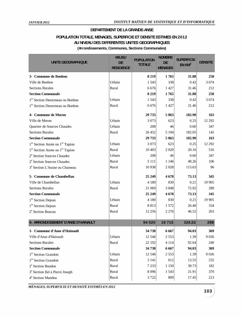
INSTITUT HAÏTIEN DE STATISTIQUE ET D’INFORMATIQUEJANVIER 2012
103MÉNAGES, SUPERFICIE ET DENSITÉ ESTIMÉS EN 2012
MILIEU NOMBRE
DE DERESIDENCE MENAGES
3- Commune de Bonbon 8 219 1 765 31.88 258
Ville de Bonbon Urbain 1 543 338 0.42 3 674
Sections Rurales Rural 6 676 1 427 31.46 212
Section Communale 8 219 1 765 31.88 258
1re Section Desormeau ou Bonbon Urbain 1 543 338 0.42 3 674
1re Section Desormeau ou Bonbon Rural 6 676 1 427 31.46 212
4- Commune de Moron 29 733 5 863 182.90 163
Ville de Moron Urbain 3 073 623 0.25 12 292
Quartier de Sources Chaudes Urbain 208 46 0.60 347
Sections Rurales Rural 26 452 5 194 182.05 145
Section Communale 29 733 5 863 182.90 163
1re Section Anote ou 1re Tapion Urbain 3 073 623 0.25 12 292
1re Section Anote ou 1re Tapion Rural 10 403 2 020 20.16 516
2e Section Sources Chaudes Urbain 208 46 0.60 347
2e Section Sources Chaudes Rural 5 111 1 146 48.26 106
3e Section L'Assise ou Chameau Rural 10 938 2 028 113.63 96
5- Commune de Chambellan 25 249 4 678 73.13 345
Ville de Chambellan Urbain 4 180 830 0.21 19 905
Sections Rurales Rural 21 069 3 848 72.92 289
Section Communale 25 249 4 678 73.13 345
1re Section Dejean Urbain 4 180 830 0.21 19 905
1re Section Dejean Rural 8 813 1 572 26.40 334
2e Section Boucan Rural 12 256 2 276 46.52 263
II- ARRONDISSEMENT D'ANSE D'HAINAULT 94 020 18 715 326.52 288
1- Commune d'Anse d'Hainault 34 738 6 667 94.03 369
Ville d'Anse d'Hainault Urbain 12 546 2 553 1.39 9 026
Sections Rurales Rural 22 192 4 114 92.64 240
Section Communale 34 738 6 667 94.03 369
1re Section Grandoit Urbain 12 546 2 553 1.39 9 026
1re Section Grandoit Rural 3 141 612 13.55 232
2e Section Boudon Rural 7 233 1 150 39.73 182
3e Section Ilet à Pierre Joseph Rural 8 096 1 543 21.91 370
4e Section Mandou Rural 3 722 809 17.45 213
POPULATIONTOTALE
SUPERFICIE
EN KM2
DEPARTEMENT DE LA GRANDE-ANSE
POPULATION TOTALE, MENAGES, SUPERFICIE ET DENSITE ESTIMES EN 2012AU NIVEAU DES DIFFERENTES UNITES GEOGRAPHIQUES
(Arrondissements, Communes, Sections Communales)
UNITE GEOGRAPHIQUE DENSITE
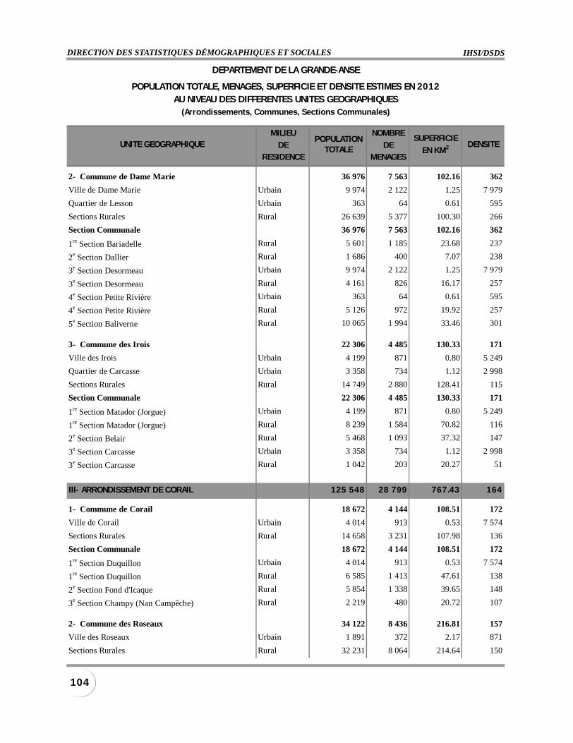
IHSI/DSDSDIRECTION DES STATISTIQUES DÉMOGRAPHIQUES ET SOCIALES
104
MILIEU NOMBRE
DE DERESIDENCE MENAGES
2- Commune de Dame Marie 36 976 7 563 102.16 362
Ville de Dame Marie Urbain 9 974 2 122 1.25 7 979
Quartier de Lesson Urbain 363 64 0.61 595
Sections Rurales Rural 26 639 5 377 100.30 266
Section Communale 36 976 7 563 102.16 362
1re Section Bariadelle Rural 5 601 1 185 23.68 237
2e Section Dallier Rural 1 686 400 7.07 238
3e Section Desormeau Urbain 9 974 2 122 1.25 7 979
3e Section Desormeau Rural 4 161 826 16.17 257
4e Section Petite Rivière Urbain 363 64 0.61 595
4e Section Petite Rivière Rural 5 126 972 19.92 257
5e Section Baliverne Rural 10 065 1 994 33.46 301
3- Commune des Irois 22 306 4 485 130.33 171
Ville des Irois Urbain 4 199 871 0.80 5 249
Quartier de Carcasse Urbain 3 358 734 1.12 2 998
Sections Rurales Rural 14 749 2 880 128.41 115
Section Communale 22 306 4 485 130.33 171
1re Section Matador (Jorgue) Urbain 4 199 871 0.80 5 249
1re Section Matador (Jorgue) Rural 8 239 1 584 70.82 116
2e Section Belair Rural 5 468 1 093 37.32 147
3e Section Carcasse Urbain 3 358 734 1.12 2 998
3e Section Carcasse Rural 1 042 203 20.27 51
III- ARRONDISSEMENT DE CORAIL 125 548 28 799 767.43 164
1- Commune de Corail 18 672 4 144 108.51 172
Ville de Corail Urbain 4 014 913 0.53 7 574
Sections Rurales Rural 14 658 3 231 107.98 136
Section Communale 18 672 4 144 108.51 172
1re Section Duquillon Urbain 4 014 913 0.53 7 574
1re Section Duquillon Rural 6 585 1 413 47.61 138
2e Section Fond d'Icaque Rural 5 854 1 338 39.65 148
3e Section Champy (Nan Campêche) Rural 2 219 480 20.72 107
2- Commune des Roseaux 34 122 8 436 216.81 157
Ville des Roseaux Urbain 1 891 372 2.17 871
Sections Rurales Rural 32 231 8 064 214.64 150
POPULATIONTOTALE
SUPERFICIE
EN KM2
DEPARTEMENT DE LA GRANDE-ANSE
POPULATION TOTALE, MENAGES, SUPERFICIE ET DENSITE ESTIMES EN 2012AU NIVEAU DES DIFFERENTES UNITES GEOGRAPHIQUES
(Arrondissements, Communes, Sections Communales)
UNITE GEOGRAPHIQUE DENSITE
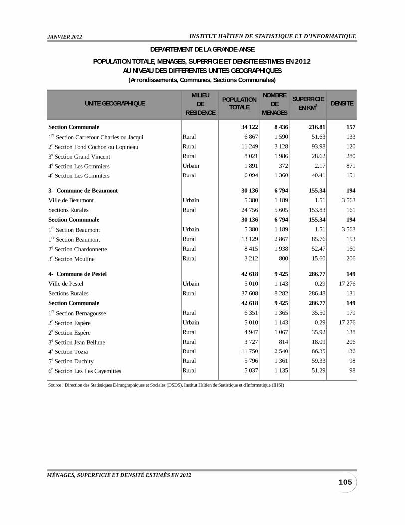
INSTITUT HAÏTIEN DE STATISTIQUE ET D’INFORMATIQUEJANVIER 2012
105MÉNAGES, SUPERFICIE ET DENSITÉ ESTIMÉS EN 2012
MILIEU NOMBRE
DE DERESIDENCE MENAGES
Section Communale 34 122 8 436 216.81 157
1re Section Carrefour Charles ou Jacqui Rural 6 867 1 590 51.63 133
2e Section Fond Cochon ou Lopineau Rural 11 249 3 128 93.98 120
3e Section Grand Vincent Rural 8 021 1 986 28.62 280
4e Section Les Gommiers Urbain 1 891 372 2.17 871
4e Section Les Gommiers Rural 6 094 1 360 40.41 151
3- Commune de Beaumont 30 136 6 794 155.34 194
Ville de Beaumont Urbain 5 380 1 189 1.51 3 563
Sections Rurales Rural 24 756 5 605 153.83 161
Section Communale 30 136 6 794 155.34 194
1re Section Beaumont Urbain 5 380 1 189 1.51 3 563
1re Section Beaumont Rural 13 129 2 867 85.76 153
2e Section Chardonnette Rural 8 415 1 938 52.47 160
3e Section Mouline Rural 3 212 800 15.60 206
4- Commune de Pestel 42 618 9 425 286.77 149
Ville de Pestel Urbain 5 010 1 143 0.29 17 276
Sections Rurales Rural 37 608 8 282 286.48 131
Section Communale 42 618 9 425 286.77 149
1re Section Bernagousse Rural 6 351 1 365 35.50 179
2e Section Espère Urbain 5 010 1 143 0.29 17 276
2e Section Espère Rural 4 947 1 067 35.92 138
3e Section Jean Bellune Rural 3 727 814 18.09 206
4e Section Tozia Rural 11 750 2 540 86.35 136
5e Section Duchity Rural 5 796 1 361 59.33 98
6e Section Les Iles Cayemittes Rural 5 037 1 135 51.29 98
Source : Direction des Statistiques Démographiques et Sociales (DSDS), Institut Haïtien de Statistique et d'Informatique (IHSI)
POPULATIONTOTALE
SUPERFICIE
EN KM2
DEPARTEMENT DE LA GRANDE-ANSE
POPULATION TOTALE, MENAGES, SUPERFICIE ET DENSITE ESTIMES EN 2012AU NIVEAU DES DIFFERENTES UNITES GEOGRAPHIQUES
(Arrondissements, Communes, Sections Communales)
UNITE GEOGRAPHIQUE DENSITE
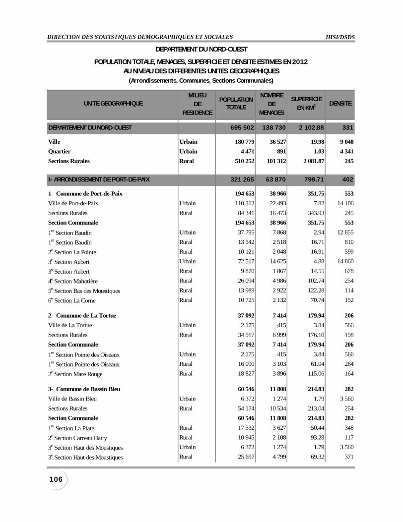
IHSI/DSDSDIRECTION DES STATISTIQUES DÉMOGRAPHIQUES ET SOCIALES
106
MILIEU NOMBRE
DE DERESIDENCE MENAGES
DEPARTEMENT DU NORD-OUEST 695 502 138 730 2 102.88 331
Ville Urbain 180 779 36 527 19.98 9 048
Quartier Urbain 4 471 891 1.03 4 341
Sections Rurales Rural 510 252 101 312 2 081.87 245
I- ARRONDISSEMENT DE PORT-DE-PAIX 321 265 63 870 799.71 402
1- Commune de Port-de-Paix 194 653 38 966 351.75 553
Ville de Port-de-Paix Urbain 110 312 22 493 7.82 14 106
Sections Rurales Rural 84 341 16 473 343.93 245
Section Communale 194 653 38 966 351.75 553
1re Section Baudin Urbain 37 795 7 868 2.94 12 855
1re Section Baudin Rural 13 542 2 518 16.71 810
2e Section La Pointe Rural 10 121 2 048 16.91 599
3e Section Aubert Urbain 72 517 14 625 4.88 14 860
3e Section Aubert Rural 9 870 1 867 14.55 678
4e Section Mahotière Rural 26 094 4 986 102.74 254
5e Section Bas des Moustiques Rural 13 989 2 922 122.28 114
6e Section La Corne Rural 10 725 2 132 70.74 152
2- Commune de La Tortue 37 092 7 414 179.94 206
Ville de La Tortue Urbain 2 175 415 3.84 566
Sections Rurales Rural 34 917 6 999 176.10 198
Section Communale 37 092 7 414 179.94 206
1re Section Pointe des Oiseaux Urbain 2 175 415 3.84 566
1re Section Pointe des Oiseaux Rural 16 090 3 103 61.04 264
2e Section Mare Rouge Rural 18 827 3 896 115.06 164
3- Commune de Bassin Bleu 60 546 11 808 214.83 282
Ville de Bassin Bleu Urbain 6 372 1 274 1.79 3 560
Sections Rurales Rural 54 174 10 534 213.04 254
Section Communale 60 546 11 808 214.83 282
1re Section La Plate Rural 17 532 3 627 50.44 348
2e Section Carreau Datty Rural 10 945 2 108 93.28 117
3e Section Haut des Moustiques Urbain 6 372 1 274 1.79 3 560
3e Section Haut des Moustiques Rural 25 697 4 799 69.32 371
POPULATIONTOTALE
SUPERFICIE
EN KM2
DEPARTEMENT DU NORD-OUEST
POPULATION TOTALE, MENAGES, SUPERFICIE ET DENSITE ESTIMES EN 2012AU NIVEAU DES DIFFERENTES UNITES GEOGRAPHIQUES
(Arrondissements, Communes, Sections Communales)
UNITE GEOGRAPHIQUE DENSITE

INSTITUT HAÏTIEN DE STATISTIQUE ET D’INFORMATIQUEJANVIER 2012
107MÉNAGES, SUPERFICIE ET DENSITÉ ESTIMÉS EN 2012
MILIEU NOMBRE
DE DERESIDENCE MENAGES
4- Commune de Chansolme 28 974 5 682 53.19 545
Ville de Chansolme Urbain 2 560 536 0.69 3 710
Sections Rurales Rural 26 414 5 146 52.50 503
Section Communale 28 974 5 682 53.19 545
1re Section Chansolme Urbain 2 560 536 0.69 3 710
1re Section Chansolme Rural 13 940 2 682 24.16 577
2e Source Beauvoir Rural 12 474 2 464 28.34 440
II- ARRONDISSEMENT DE SAINT LOUIS DU NORD 139 869 26 218 187.74 745
1- Commune de Saint Louis du Nord 111 033 20 820 125.60 884
Ville de Saint Louis du Nord Urbain 33 309 6 195 2.21 15 072
Quartier de Guichard Urbain 292 56 0.32 913
Quartier de Bonneau Urbain 2 390 449 0.38 6 289
Sections Rurales Rural 75 042 14 120 122.69 612
Section Communale 111 033 20 820 125.60 884
1re Section Rivière des Nègres Urbain 292 56 0.32 913
1re Section Rivière des Nègres Rural 11 658 2 291 17.92 651
2e Section Derourvay Urbain 25 375 4 766 1.62 15 664
2e Section Derourvay Rural 10 168 1 679 11.10 916
3e Section des Granges Urbain 7 934 1 429 0.59 13 447
3e Section des Granges Rural 16 349 3 068 25.75 635
4e Section Rivière de Barre Rural 17 618 3 373 23.62 746
5e Section Bonneau Urbain 2 390 449 0.38 6 289
5e Section Bonneau Rural 12 060 2 240 21.49 561
6e Section Lafague (Chamoise) Rural 7 189 1 469 22.81 315
2- Commune d'Anse-à-Foleur 28 836 5 398 62.14 464
Ville d'Anse-à-Foleur Urbain 6 420 1 299 0.56 11 464
Sections Rurales Rural 22 416 4 099 61.58 364
Section Communale 28 836 5 398 62.14 464
1re Section Bas de Sainte Anne Rural 10 058 1 822 22.02 457
2e Section Mayance Rural 6 199 1 185 21.77 285
3e Section Côtes de Fer Urbain 6 420 1 299 0.56 11 464
3e Section Côtes de Fer Rural 6 159 1 092 17.79 346
POPULATIONTOTALE
SUPERFICIE
EN KM2
DEPARTEMENT DU NORD-OUEST
POPULATION TOTALE, MENAGES, SUPERFICIE ET DENSITE ESTIMES EN 2012AU NIVEAU DES DIFFERENTES UNITES GEOGRAPHIQUES
(Arrondissements, Communes, Sections Communales)
UNITE GEOGRAPHIQUE DENSITE
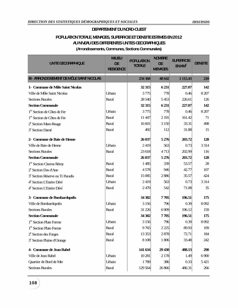
IHSI/DSDSDIRECTION DES STATISTIQUES DÉMOGRAPHIQUES ET SOCIALES
108
MILIEU NOMBRE
DE DERESIDENCE MENAGES
III- ARRONDISSEMENT DE MÔLE SAINT NICOLAS 234 368 48 642 1 115.43 210
1- Commune de Môle Saint Nicolas 32 315 6 231 227.07 142
Ville de Môle Saint Nicolas Urbain 3 775 778 0.46 8 207
Sections Rurales Rural 28 540 5 453 226.61 126
Section Communale 32 315 6 231 227.07 142
1re Section de Côtes de Fer Urbain 3 775 778 0.46 8 207
1re Section de Côtes de Fer Rural 11 447 2 191 161.42 71
2e Section Mare-Rouge Rural 16 601 3 150 33.31 498
3e Section Damé Rural 492 112 31.88 15
2- Commune de Baie de Henne 26 037 5 276 203.72 128
Ville de Baie de Henne Urbain 2 419 563 0.73 3 314
Sections Rurales Rural 23 618 4 713 202.99 116
Section Communale 26 037 5 276 203.72 128
1re Section Citerne Rémy Rural 1 485 339 53.57 28
2e Section Dos d'Ane Rural 4 578 946 42.77 107
3e Section Réserve ou Ti Paradis Rural 15 085 2 886 35.57 424
4e Section L'Estère Déré Urbain 2 419 563 0.73 3 314
4e Section L'Estère Déré Rural 2 470 542 71.08 35
3- Commune de Bombardopolis 34 382 7 705 196.51 175
Ville de Bombardopolis Urbain 3 156 796 0.39 8 092
Sections Rurales Rural 31 226 6 909 196.12 159
Section Communale 34 382 7 705 196.51 175
1re Section Plate Forme Urbain 3 156 796 0.39 8 092
1re Section Plate Forme Rural 9 765 2 225 89.93 109
2e Section des Forges Rural 13 353 2 878 72.71 184
3e Section Plaine d'Orange Rural 8 108 1 806 33.48 242
4- Commune de Jean Rabel 141 634 29 430 488.13 290
Ville de Jean Rabel Urbain 10 281 2 178 1.49 6 900
Quartier de Bord de Mer Urbain 1 789 386 0.33 5 421
Sections Rurales Rural 129 564 26 866 486.31 266
POPULATIONTOTALE
SUPERFICIE
EN KM2
DEPARTEMENT DU NORD-OUEST
POPULATION TOTALE, MENAGES, SUPERFICIE ET DENSITE ESTIMES EN 2012AU NIVEAU DES DIFFERENTES UNITES GEOGRAPHIQUES
(Arrondissements, Communes, Sections Communales)
UNITE GEOGRAPHIQUE DENSITE
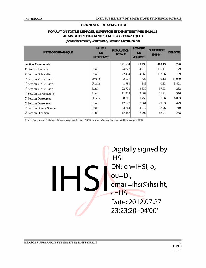
INSTITUT HAÏTIEN DE STATISTIQUE ET D’INFORMATIQUEJANVIER 2012
109MÉNAGES, SUPERFICIE ET DENSITÉ ESTIMÉS EN 2012
MILIEU NOMBRE
DE DERESIDENCE MENAGES
Section Communale 141 634 29 430 488.13 290
1re Section Lacoma Rural 24 222 4 910 135.41 179
2e Section Guinaudée Rural 22 454 4 669 112.96 199
3e Section Vieille Hatte Urbain 2 076 422 0.13 15 969
3e Section Vieille Hatte Urbain 1 789 386 0.33 5 421
3e Section Vieille Hatte Rural 22 721 4 830 97.93 232
4e Section La Montagne Rural 11 734 2 482 31.21 376
5e Section Dessources Urbain 8 205 1 756 1.36 6 033
5e Section Dessources Rural 12 723 2 561 29.63 429
6e Section Grande Source Rural 23 264 4 917 32.76 710
7e Section Diondion Rural 12 446 2 497 46.41 268
Source : Direction des Statistiques Démographiques et Sociales (DSDS), Institut Haïtien de Statistique et d'Informatique (IHSI)
POPULATIONTOTALE
SUPERFICIE
EN KM2
DEPARTEMENT DU NORD-OUEST
POPULATION TOTALE, MENAGES, SUPERFICIE ET DENSITE ESTIMES EN 2012AU NIVEAU DES DIFFERENTES UNITES GEOGRAPHIQUES
(Arrondissements, Communes, Sections Communales)
UNITE GEOGRAPHIQUE DENSITE
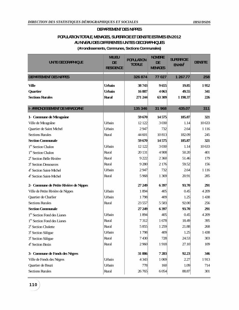
IHSI/DSDSDIRECTION DES STATISTIQUES DÉMOGRAPHIQUES ET SOCIALES
110
MILIEU NOMBRE
DE DERESIDENCE MENAGES
DEPARTEMENT DES NIPPES 326 874 77 027 1 267.77 258
Ville Urbain 38 743 9 655 19.85 1 952
Quartier Urbain 16 887 4 063 49.55 341
Sections Rurales Rural 271 244 63 309 1 198.37 226
I- ARRONDISSEMENT DE MIRAGOANE 135 346 31 968 435.07 311
1- Commune de Miragoâne 59 670 14 575 185.87 321
Ville de Miragoâne Urbain 12 122 3 030 1.14 10 633
Quartier de Saint Michel Urbain 2 947 732 2.64 1 116
Sections Rurales Rural 44 601 10 813 182.09 245
Section Communale 59 670 14 575 185.87 321
1re Section Chalon Urbain 12 122 3 030 1.14 10 633
1re Section Chalon Rural 20 131 4 908 50.20 401
2e Section Belle Rivière Rural 9 222 2 360 51.46 179
3e Section Dessources Rural 9 280 2 176 59.52 156
4e Section Saint-Michel Urbain 2 947 732 2.64 1 116
4e Section Saint-Michel Rural 5 968 1 369 20.91 285
2- Commune de Petite Rivière de Nippes 27 249 6 397 93.70 291
Ville de Petite Rivière de Nippes Urbain 1 894 405 0.45 4 209
Quartier de Charlier Urbain 1 798 409 1.25 1 438
Sections Rurales Rural 23 557 5 583 92.00 256
Section Communale 27 249 6 397 93.70 291
1re Section Fond des Lianes Urbain 1 894 405 0.45 4 209
1re Section Fond des Lianes Rural 7 312 1 678 18.49 395
2e Section Cholette Rural 5 855 1 259 21.88 268
3e Section Silègue Urbain 1 798 409 1.25 1 438
3e Section Silègue Rural 7 430 728 24.53 303
4e Section Bezin Rural 2 960 1 918 27.10 109
3- Commune de Fonds des Nègres 31 886 7 283 92.23 346
Ville de Fonds des Nègres Urbain 4 343 1 069 2.27 1 913
Quartier de Bouzi Urbain 778 160 1.09 714
Sections Rurales Rural 26 765 6 054 88.87 301
POPULATIONTOTALE
SUPERFICIE
EN KM2
DEPARTEMENT DES NIPPES
POPULATION TOTALE, MENAGES, SUPERFICIE ET DENSITE ESTIMES EN 2012AU NIVEAU DES DIFFERENTES UNITES GEOGRAPHIQUES
(Arrondissements, Communes, Sections Communales)
DENSITEUNITE GEOGRAPHIQUE
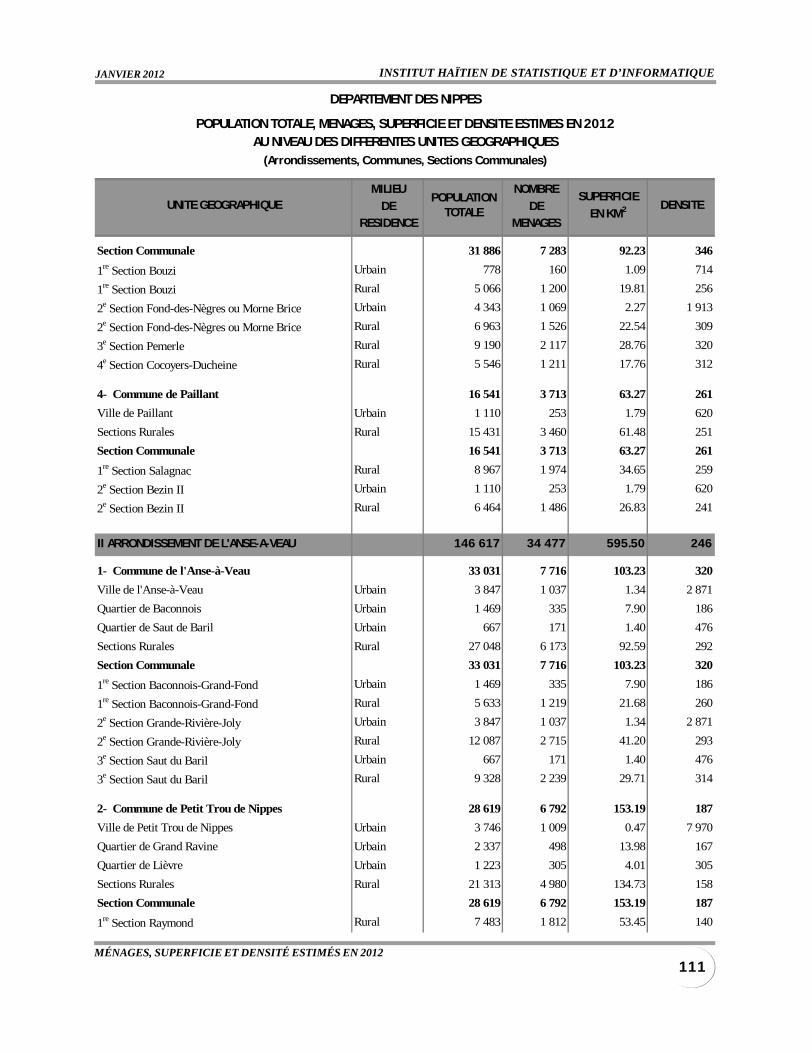
INSTITUT HAÏTIEN DE STATISTIQUE ET D’INFORMATIQUEJANVIER 2012
111MÉNAGES, SUPERFICIE ET DENSITÉ ESTIMÉS EN 2012
MILIEU NOMBRE
DE DERESIDENCE MENAGES
Section Communale 31 886 7 283 92.23 346
1re Section Bouzi Urbain 778 160 1.09 714
1re Section Bouzi Rural 5 066 1 200 19.81 256
2e Section Fond-des-Nègres ou Morne Brice Urbain 4 343 1 069 2.27 1 913
2e Section Fond-des-Nègres ou Morne Brice Rural 6 963 1 526 22.54 309
3e Section Pemerle Rural 9 190 2 117 28.76 320
4e Section Cocoyers-Ducheine Rural 5 546 1 211 17.76 312
4- Commune de Paillant 16 541 3 713 63.27 261
Ville de Paillant Urbain 1 110 253 1.79 620
Sections Rurales Rural 15 431 3 460 61.48 251
Section Communale 16 541 3 713 63.27 261
1re Section Salagnac Rural 8 967 1 974 34.65 259
2e Section Bezin II Urbain 1 110 253 1.79 620
2e Section Bezin II Rural 6 464 1 486 26.83 241
II ARRONDISSEMENT DE L'ANSE-A-VEAU 146 617 34 477 595.50 246
1- Commune de l'Anse-à-Veau 33 031 7 716 103.23 320
Ville de l'Anse-à-Veau Urbain 3 847 1 037 1.34 2 871
Quartier de Baconnois Urbain 1 469 335 7.90 186
Quartier de Saut de Baril Urbain 667 171 1.40 476
Sections Rurales Rural 27 048 6 173 92.59 292
Section Communale 33 031 7 716 103.23 320
1re Section Baconnois-Grand-Fond Urbain 1 469 335 7.90 186
1re Section Baconnois-Grand-Fond Rural 5 633 1 219 21.68 260
2e Section Grande-Rivière-Joly Urbain 3 847 1 037 1.34 2 871
2e Section Grande-Rivière-Joly Rural 12 087 2 715 41.20 293
3e Section Saut du Baril Urbain 667 171 1.40 476
3e Section Saut du Baril Rural 9 328 2 239 29.71 314
2- Commune de Petit Trou de Nippes 28 619 6 792 153.19 187
Ville de Petit Trou de Nippes Urbain 3 746 1 009 0.47 7 970
Quartier de Grand Ravine Urbain 2 337 498 13.98 167
Quartier de Lièvre Urbain 1 223 305 4.01 305
Sections Rurales Rural 21 313 4 980 134.73 158
Section Communale 28 619 6 792 153.19 187
1re Section Raymond Rural 7 483 1 812 53.45 140
POPULATIONTOTALE
SUPERFICIE
EN KM2
DEPARTEMENT DES NIPPES
POPULATION TOTALE, MENAGES, SUPERFICIE ET DENSITE ESTIMES EN 2012AU NIVEAU DES DIFFERENTES UNITES GEOGRAPHIQUES
(Arrondissements, Communes, Sections Communales)
DENSITEUNITE GEOGRAPHIQUE
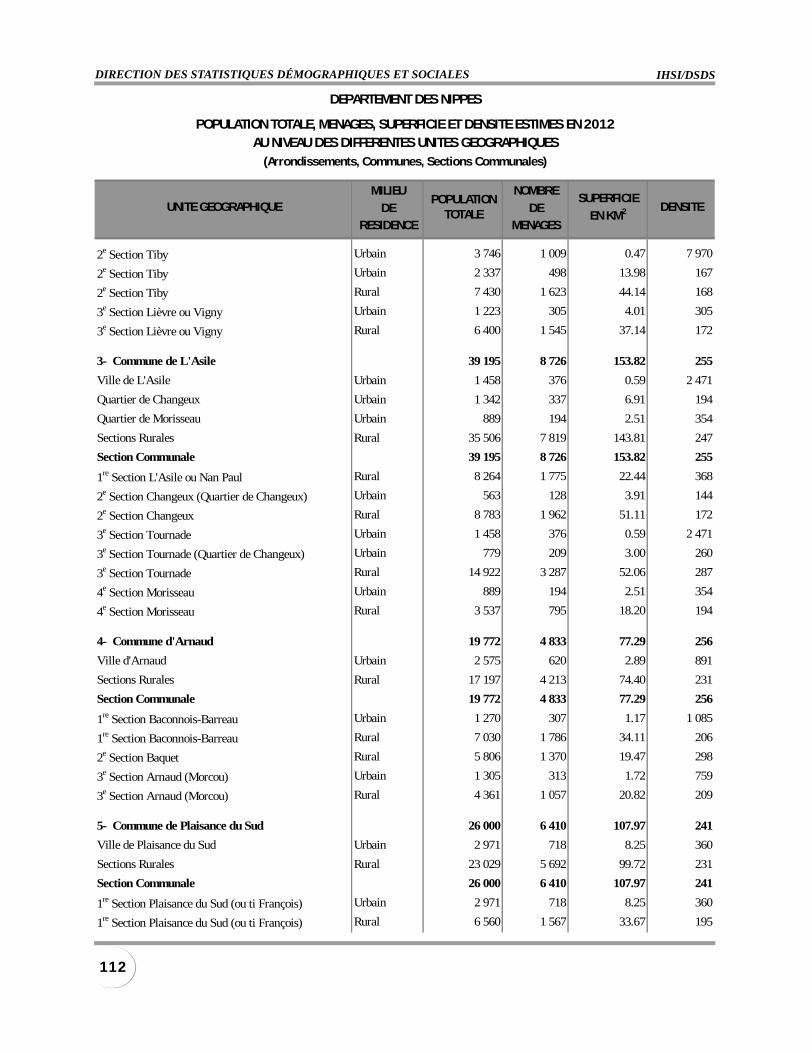
IHSI/DSDSDIRECTION DES STATISTIQUES DÉMOGRAPHIQUES ET SOCIALES
112
MILIEU NOMBRE
DE DERESIDENCE MENAGES
2e Section Tiby Urbain 3 746 1 009 0.47 7 970
2e Section Tiby Urbain 2 337 498 13.98 167
2e Section Tiby Rural 7 430 1 623 44.14 168
3e Section Lièvre ou Vigny Urbain 1 223 305 4.01 305
3e Section Lièvre ou Vigny Rural 6 400 1 545 37.14 172
3- Commune de L'Asile 39 195 8 726 153.82 255
Ville de L'Asile Urbain 1 458 376 0.59 2 471
Quartier de Changeux Urbain 1 342 337 6.91 194
Quartier de Morisseau Urbain 889 194 2.51 354
Sections Rurales Rural 35 506 7 819 143.81 247
Section Communale 39 195 8 726 153.82 255
1re Section L'Asile ou Nan Paul Rural 8 264 1 775 22.44 368
2e Section Changeux (Quartier de Changeux) Urbain 563 128 3.91 144
2e Section Changeux Rural 8 783 1 962 51.11 172
3e Section Tournade Urbain 1 458 376 0.59 2 471
3e Section Tournade (Quartier de Changeux) Urbain 779 209 3.00 260
3e Section Tournade Rural 14 922 3 287 52.06 287
4e Section Morisseau Urbain 889 194 2.51 354
4e Section Morisseau Rural 3 537 795 18.20 194
4- Commune d'Arnaud 19 772 4 833 77.29 256
Ville d'Arnaud Urbain 2 575 620 2.89 891
Sections Rurales Rural 17 197 4 213 74.40 231
Section Communale 19 772 4 833 77.29 256
1re Section Baconnois-Barreau Urbain 1 270 307 1.17 1 085
1re Section Baconnois-Barreau Rural 7 030 1 786 34.11 206
2e Section Baquet Rural 5 806 1 370 19.47 298
3e Section Arnaud (Morcou) Urbain 1 305 313 1.72 759
3e Section Arnaud (Morcou) Rural 4 361 1 057 20.82 209
5- Commune de Plaisance du Sud 26 000 6 410 107.97 241
Ville de Plaisance du Sud Urbain 2 971 718 8.25 360
Sections Rurales Rural 23 029 5 692 99.72 231
Section Communale 26 000 6 410 107.97 241
1re Section Plaisance du Sud (ou ti François) Urbain 2 971 718 8.25 360
1re Section Plaisance du Sud (ou ti François) Rural 6 560 1 567 33.67 195
POPULATIONTOTALE
SUPERFICIE
EN KM2
DEPARTEMENT DES NIPPES
POPULATION TOTALE, MENAGES, SUPERFICIE ET DENSITE ESTIMES EN 2012AU NIVEAU DES DIFFERENTES UNITES GEOGRAPHIQUES
(Arrondissements, Communes, Sections Communales)
DENSITEUNITE GEOGRAPHIQUE
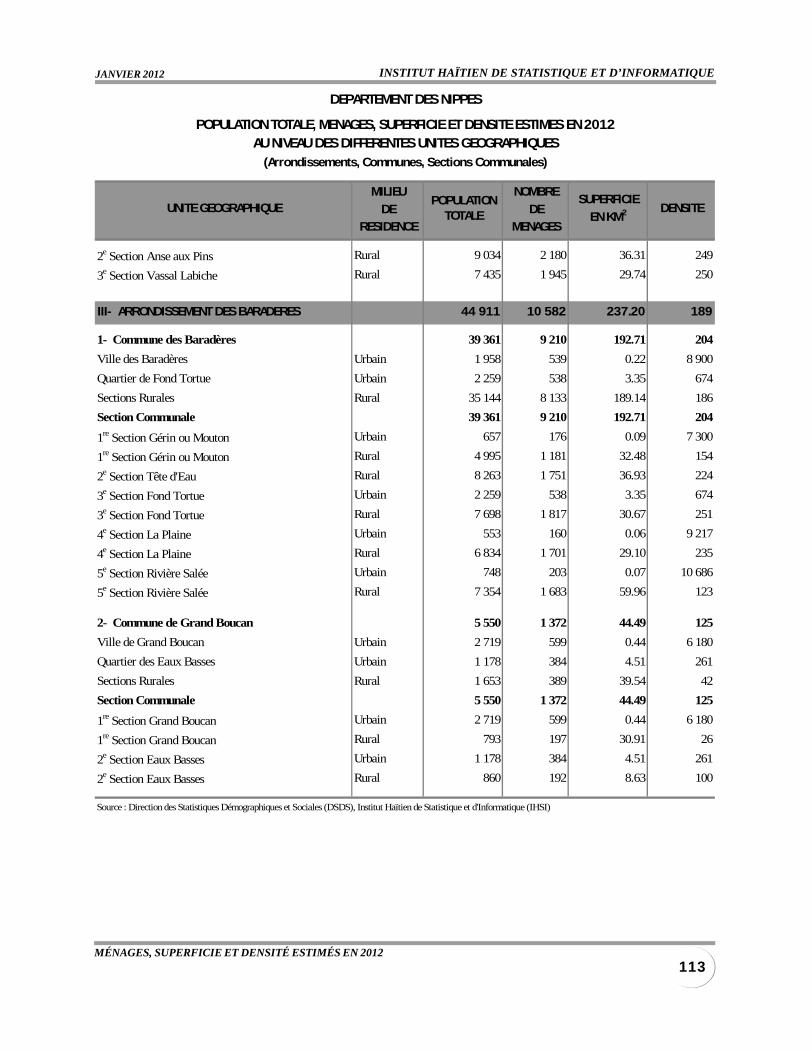
INSTITUT HAÏTIEN DE STATISTIQUE ET D’INFORMATIQUEJANVIER 2012
113MÉNAGES, SUPERFICIE ET DENSITÉ ESTIMÉS EN 2012
MILIEU NOMBRE
DE DERESIDENCE MENAGES
2e Section Anse aux Pins Rural 9 034 2 180 36.31 249
3e Section Vassal Labiche Rural 7 435 1 945 29.74 250
III- ARRONDISSEMENT DES BARADERES 44 911 10 582 237.20 189
1- Commune des Baradères 39 361 9 210 192.71 204
Ville des Baradères Urbain 1 958 539 0.22 8 900
Quartier de Fond Tortue Urbain 2 259 538 3.35 674
Sections Rurales Rural 35 144 8 133 189.14 186
Section Communale 39 361 9 210 192.71 204
1re Section Gérin ou Mouton Urbain 657 176 0.09 7 300
1re Section Gérin ou Mouton Rural 4 995 1 181 32.48 154
2e Section Tête d'Eau Rural 8 263 1 751 36.93 224
3e Section Fond Tortue Urbain 2 259 538 3.35 674
3e Section Fond Tortue Rural 7 698 1 817 30.67 251
4e Section La Plaine Urbain 553 160 0.06 9 217
4e Section La Plaine Rural 6 834 1 701 29.10 235
5e Section Rivière Salée Urbain 748 203 0.07 10 686
5e Section Rivière Salée Rural 7 354 1 683 59.96 123
2- Commune de Grand Boucan 5 550 1 372 44.49 125
Ville de Grand Boucan Urbain 2 719 599 0.44 6 180
Quartier des Eaux Basses Urbain 1 178 384 4.51 261
Sections Rurales Rural 1 653 389 39.54 42
Section Communale 5 550 1 372 44.49 125
1re Section Grand Boucan Urbain 2 719 599 0.44 6 180
1re Section Grand Boucan Rural 793 197 30.91 26
2e Section Eaux Basses Urbain 1 178 384 4.51 261
2e Section Eaux Basses Rural 860 192 8.63 100
Source : Direction des Statistiques Démographiques et Sociales (DSDS), Institut Haïtien de Statistique et d'Informatique (IHSI)
POPULATIONTOTALE
SUPERFICIE
EN KM2
DEPARTEMENT DES NIPPES
POPULATION TOTALE, MENAGES, SUPERFICIE ET DENSITE ESTIMES EN 2012AU NIVEAU DES DIFFERENTES UNITES GEOGRAPHIQUES
(Arrondissements, Communes, Sections Communales)
DENSITEUNITE GEOGRAPHIQUE