l’exploitation d’osm par l’aurh et ses avantages pour le projet européen « weastflows »
TRANSCRIPT

Session « Appropriation » :l’exploitation d’OSM par l’AURH &
avantages pour le projet « Weastflows »State of the Map France 2014
Paris, 4 avril 2014JF Mary, AURH

2
Explo
itatio
n OS
M –
AURH
–Pr
ojet e
urop
éen
Wea
stflow
s–04
/04/
2014
–v1
.1 –
CC:B
Y-SA
Deux années de cheminement
• Contexte– L’AURH– Le projet européen, Weastflows– Comment ? -> avec un SIG
• Posture et besoins– Une BDG sur les réseaux de transports,
internationale, partageable, pérenne• Comment
– Chargement sous PostgreSQL– Exploitation progressive : Atlas, Geoweastflows, Analyse
Beaucoup de changements en 2 ans concernant l’ouverture
des données

3
Explo
itatio
n OS
M –
AURH
–Pr
ojet e
urop
éen
Wea
stflow
s–04
/04/
2014
–v1
.1 –
CC:B
Y-SA
Agence d’urbanisme ?
Tourisme
HabitatDéveloppement durable
Transports
Aménagement et Urbanisme
Economie
PopulationDémographie
Industrie
Habitat locatif social
Cadre juridique
Port
Société
Aménagement local
Environnement
Foncier
PaysageSanté publique Education
Trafic
Modes
Logistique
Commerce
Urbanisme réglementaire
Construction
Gouvernance
EmploiMarché du
travailFormation
Equipements
Collectivités
Ressources
Loisirs
Transactions immobilières
Agriculture
ConjonctureProjets
AdministrationImmobilier de bureau
Culture
Héritage
Infrastructures
Migrations alternantes
Transportpublic
Etablissements

4
Explo
itatio
n OS
M –
AURH
–Pr
ojet e
urop
éen
Wea
stflow
s–04
/04/
2014
–v1
.1 –
CC:B
Y-SA
Notre agence d’urbanisme
Urbanisme et Géographie
Observation (économie, foncier, population,
immobilier…)
Projets de territoire, urbanisme
règlementaire, projets urbains
Études à la demande (commerce, transports
urbains...)
Prospective:Axe Seine,
Projets européens..

5
Explo
itatio
n OS
M –
AURH
–Pr
ojet e
urop
éen
Wea
stflow
s–04
/04/
2014
–v1
.1 –
CC:B
Y-SA
Nos « territoires »
1 - « le Centre ancien »petits territoires,grands projets
2 - Le Havrela CODAH« le centre » 3 - Le territoire d’étude
L’Estuaire de la SeinePôle métropolitain?
Remerciements à PNG factory - http://www.pngfactory.net – pour les icônes

6
Explo
itatio
n OS
M –
AURH
–Pr
ojet e
urop
éen
Wea
stflow
s–04
/04/
2014
–v1
.1 –
CC:B
Y-SA
Du local au global
Remerciements à PNG factory - http://www.pngfactory.net – pour les icônes
3 - Le territoire d’étudeL’Estuaire de la SeinePôle métropolitain?Bassin de vie
4 - la Vallée de Seine« Grand Paris »Seine Gateway® 5 – l’Europe
du Nord-Ouestla prospective

7
Explo
itatio
n OS
M –
AURH
–Pr
ojet e
urop
éen
Wea
stflow
s–04
/04/
2014
–v1
.1 –
CC:B
Y-SA
Le projet européen Weastflows
• Projet européen (2011-2015)• Interreg IVB• Budget : 9 Millions €
50% ERDF• couvrant l’Europe du Nord-Ouest• 22 partenaires, 30 observateurs• Objet : fret, transport des marchandises
et infrastructures de transport

8
Explo
itatio
n OS
M –
AURH
–Pr
ojet e
urop
éen
Wea
stflow
s–04
/04/
2014
–v1
.1 –
CC:B
Y-SA
Une Meilleure circulation de la marchandise en ENO ?
• Trouver des routes « Ouest-Est »• Réduire la congestion• Rechercher des alternatives à la route• Développer l’intermodalité• Mieux utiliser les infrastructures

9
Explo
itatio
n OS
M –
AURH
–Pr
ojet e
urop
éen
Wea
stflow
s–04
/04/
2014
–v1
.1 –
CC:B
Y-SA
Notre action, notre besoin
• Action 1 : « Infrastructure et territoire »-> nœuds, liens, « capacitaire »
• Action 2 : « Trafic » « Utilisation des infrastructures »• Action 3 : « Gateways »
(connexion local / mondial)• Action 4 : « Interactions », « matrice »• Action 5 : « Routing »• Actions 6 et 7 : « NTIC »• Actions >=8 : Communication, interactions avec les
autres projets, évaluation, événements internationaux
Le SIG : Action « 0 » ?

10
Explo
itatio
n OS
M –
AURH
–Pr
ojet e
urop
éen
Wea
stflow
s–04
/04/
2014
–v1
.1 –
CC:B
Y-SA
Notre posture
• Pas de donnée européenne sur les réseaux?
• Au-delà de notre action : le SIG– Partager de la donnée– Pérenniser l’information– Cartographier, communiquer
• Choix d’OpenStreetMap (OSM) - et de l’open data• Promotion d’une plateforme cartographique

Pourquoi OSM ?
State of the Map 2014 FranceParis, 4 avril 2014
JF Mary, AURH

12
Explo
itatio
n OS
M –
AURH
–Pr
ojet e
urop
éen
Wea
stflow
s–04
/04/
2014
–v1
.1 –
CC:B
Y-SA
Pourquoi OpenStreetMap ?• Géoréférencé• Documenté (le wiki)• Utilisé• Partageable• Couverture mondiale• Gratuit, libre, ouvert
(CC-BY-SA, fin 2011)– GISCO …
réseaux de transport?– TEN-T Portal:
données non ouvertes
• CODAH (Le Havre), RGVDH:– http://geo.lehavre.fr/
• France, IGN, RGE:– http://professionnels.ign.fr/rge
…• Europe, GISCO:
– http://epp.eurostat.ec.europa.eu/portal/page/portal/gisco_Geographical_information_maps/geodata/reference
• World, OpenStreetMap:– www.openstreetmap.org
Changements de paradigme

13
Explo
itatio
n OS
M –
AURH
–Pr
ojet e
urop
éen
Wea
stflow
s–04
/04/
2014
–v1
.1 –
CC:B
Y-SA
Aperçu à moyenne échelle(1/ 100 000e Le Havre, Voies ferrées)
Navteq®:Only the
passengerrailways
OpenStreetMap(OSM):
close to the reference IGN RGE®:
the referencedataset
On the map below:546 edges206.4 kms
On the map above:683 edges373.0 kms
On the map above: 137 edges57.8 kms
Tests réalisésen octobre 2011

14
Explo
itatio
n OS
M –
AURH
–Pr
ojet e
urop
éen
Wea
stflow
s–04
/04/
2014
–v1
.1 –
CC:B
Y-SA
Aperçu à moyenne échelle(1/ 100 000e Le Havre - Routes)
Navteq®:All edges for
the navigation
OpenStreetMap® (OSM):
The same cumulative Length of roads than
Navteq® but with less objects IGN RGE®:
the topographicreference dataset
30 310 edges3 635 kms
8 165 edges2 184 kms
17 436 edges2 219 kms
Tests réalisésen octobre 2011

15
Explo
itatio
n OS
M –
AURH
–Pr
ojet e
urop
éen
Wea
stflow
s–04
/04/
2014
–v1
.1 –
CC:B
Y-SA
Aperçu à grande échelle(1 / 10 000e)
For the same areaRailways Roads
Tests réalisésen octobre 2011

16
Explo
itatio
n OS
M –
AURH
–Pr
ojet e
urop
éen
Wea
stflow
s–04
/04/
2014
–v1
.1 –
CC:B
Y-SA
Aperçu à grande échelle(1 / 2 000e)
Tests réalisésen octobre 2011

OSM -> SIG
State of the Map 2014 FranceParis, 4 avril 2014
JF Mary, AURH

18
Explo
itatio
n OS
M –
AURH
–Pr
ojet e
urop
éen
Wea
stflow
s–04
/04/
2014
–v1
.1 –
CC:B
Y-SA
2012 : l’année du changement
• Choix d’OSM présenté aux partenaires (11.2011)• INSPIRE -> Modélisation, Dictionnaire de données
(mars 2012)• Expérimentations (shapefile)• Rencontre avec Christian Quest
(Rencontres SIG la Lettre, mai 2012)Choix d’utiliser le format osm natif : fichier planet
• http://download.geofabrik.de/europe.htmlChargement (juillet 2012) sous PostgreSQL

19
Explo
itatio
n OS
M –
AURH
–Pr
ojet e
urop
éen
Wea
stflow
s–04
/04/
2014
–v1
.1 –
CC:B
Y-SA
Méthodologie – principaux rappels :
Etape 1 :Données
sélectionnées et formatées selon le
Dictionnaire de données (INSPIRE)
Classification des données (European local)
Collaboration avec les
partenaires
Consolidation des informations dans le SIG
Cartographie
OSMImport (États) Chargement
OSMSélection et formatage
Ajout de données
Classification(TEN-T)
GISdataset (v2)
Atlas(v3)
Données libres
Etape 2 : Etape 3
Etape 4 :
Etape 5 : Etape 6 :
OSM
www.openstreetmap.fr/

20
Explo
itatio
n OS
M –
AURH
–Pr
ojet e
urop
éen
Wea
stflow
s–04
/04/
2014
–v1
.1 –
CC:B
Y-SA
Appui de Frédéric James,SSII Initio® au Havre pour :
• Installer et dimensionner PostgreSQL
• Exploiter l’outil osmosis(fichier planet-> PostgreSQL)
• SQL + scripts• Sélectionner, extraire• Mettre en forme les
données (Postgres) dans une structure en « layer », (géométrie et classe attributaire)
Planet -> PostgreSQL
21
Explo
itatio
n OS
M –
AURH
–Pr
ojet e
urop
éen
Wea
stflow
s–04
/04/
2014
–v1
.1 –
CC:B
Y-SA
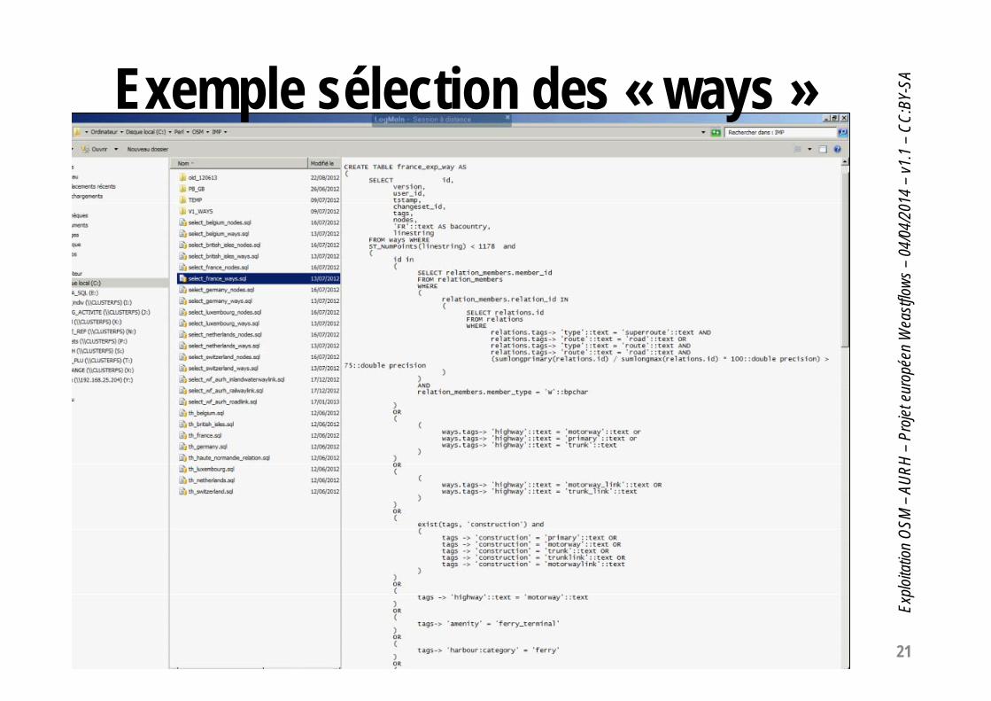
Exemple sélection des « ways »

22
Explo
itatio
n OS
M –
AURH
–Pr
ojet e
urop
éen
Wea
stflow
s–04
/04/
2014
–v1
.1 –
CC:B
Y-SA
Exemple sélection des « nodes »

23
Explo
itatio
n OS
M –
AURH
–Pr
ojet e
urop
éen
Wea
stflow
s–04
/04/
2014
–v1
.1 –
CC:B
Y-SA
Première sélection (2012)Ordre OSM ways W_R W_R_M nodes N_R N_R_M
BE(belgium)
28 541 1 583 8 163 74 586
UK(bristish_isles)
32 816 358 1 663
FR(France)
283 357 39 061 408 525 37 825 520 2 383
DE(germany)
425 909 63 404 815 370 134 991 3 053 15 426
IE(Ireland)
LU(Luxemburg)
4 676 369 6 074 939 14 100
NL(Netherlands)
63 916 5 346 92 150 16 853 190 1 118
SZ(Switzerland)
57 087 6 390 86 557 13 930 526 1 684

24
Explo
itatio
n OS
M –
AURH
–Pr
ojet e
urop
éen
Wea
stflow
s–04
/04/
2014
–v1
.1 –
CC:B
Y-SA
Base « wf_aurh »: exroutes et classification• Script de création de la base• Travail par classe d’entités
(ici « RoadLink ») ->• Ventilation (attribut, valeurs)
ici attribut « roformway »
insert into roadlink(osm_id,geom,gnname,ronroadcod, tnauthorit, roeroadnum,osm_type, osm_subtyp) SELECT id,linestring,ways.tags->'name' as gname, ways.tags->'ref' as ronroadcod, ways.tags->'operator' as tnauthorit, ways.tags->'int_ref' as ronroadnum, 'highways', ways.tags->'highway' as subtyp from wayswhere tags->'highway'=tags->'highway' or tags->'construction'='primary' or tags->'construction'='motorway' or tags->'construction'='trunk' or tags->'construction'='trunklink' or tags->'construction'='motorwaylink';
-- La requête a été exécutée avec succés : 524706 lignes modifiées. La requête a été exécutée en 19879 ms.

25
Explo
itatio
n OS
M –
AURH
–Pr
ojet e
urop
éen
Wea
stflow
s–04
/04/
2014
–v1
.1 –
CC:B
Y-SA
Base « wf_aurh » : ex. « routes » et « classification morphologique » (roformway)-- roformwayupdate roadlink set roformway='motorways' where osm_id in (select id from ways where tags->'highway'='motorway');-- 23 secupdate roadlink set roformway='slipRoad' where osm_id in (select id from ways where tags->'highway'='motorway_link' or tags->'highway'='trunk_link' or tags->'highway'='primary_link');-- 24 Secupdate roadlink set roformway='freeway' where osm_id in (select id from ways where tags->'highway'='trunk');-- 19 Secupdate roadlink set roformway='dualCarriageWay' where osm_id in (select id from ways where tags->'oneway'='yes' and tags->'highway'!='motorway' and tags->'highway'!='trunk') and rolanes >2;-- 2 Secupdate roadlink set roformway='Roundabout' where osm_id in (select id from ways where tags->'junction'='roundabout');-- 10 secupdate roadlink set roformway='EntranceOrExitServices' where osm_id in (select id from ways where tags->'highway'='service');-- 3 Secdelete from roadlink where osm_id in (select id from ways where tags->'highway'='track' or tags->'highway'='cycleway' or tags->'highway'='footway' or tags->'highway'='platform' or tags->'highway'='unclassified' or tags->'highway'='steps' or tags->'highway'='bridleway' or tags->'highway'='pedestrian' or tags->'highway'='path' )-- 6 Secupdate roadlink set roformway='SingleCarriageWay' where roformway is null;

26
Explo
itatio
n OS
M –
AURH
–Pr
ojet e
urop
éen
Wea
stflow
s–04
/04/
2014
–v1
.1 –
CC:B
Y-SA
Cartographie – ContrôleCréation – Mise à Jour• Utilisation de la carte pour contrôler / enrichir• Création : Exemple des Ports
Bing Maps® aerial et World Port Index• Complément / Correction:
– Exemple « CEMT Class » (iwcemtclass)source VNF pour la France
– Exemple « Railway Electrification » (raelectri)source : RFF, SNIT pour la France
• Classification / hiérarchisation TEN-Tsource : European Commission,DG MOVE, TENtec information system
Autres sources :World Port Index(National GeospatialIntelligence Agency)Corine Land CoverEurostatVoies navigables de FranceBP2S…

27
Explo
itatio
n OS
M –
AURH
–Pr
ojet e
urop
éen
Wea
stflow
s–04
/04/
2014
–v1
.1 –
CC:B
Y-SA
Résultat : Exemple « roadlink »

OSM -> SIG -> Atlas Weastflows
State of the Map 2014 FranceParis, 4 avril 2014
JF Mary, AURH

29
Explo
itatio
n OS
M –
AURH
–Pr
ojet e
urop
éen
Wea
stflow
s–04
/04/
2014
–v1
.1 –
CC:B
Y-SA
Data source : © CorineLandCover 2006 powered by AURHBoundaries © MBR and EuroGeographics, © ESRI
© les contributeurs d’OpenStreetMap® AURH – 2013-02

30
Explo
itatio
n OS
M –
AURH
–Pr
ojet e
urop
éen
Wea
stflow
s–04
/04/
2014
–v1
.1 –
CC:B
Y-SA
Data source : © European Commission, DG MOVE, TENtec information systemBoundaries © MBR and EuroGeographics, © ESRI
© les contributeurs d’OpenStreetMap® AURH – 2013.02

31
Explo
itatio
n OS
M –
AURH
–Pr
ojet e
urop
éen
Wea
stflow
s–04
/04/
2014
–v1
.1 –
CC:B
Y-SA
Source des données : © EurostatBoundaries © MBR and EuroGeographics © ESRI© les contributeurs d’OpenStreetMap® AURH, 2013-02

32
Explo
itatio
n OS
M –
AURH
–Pr
ojet e
urop
éen
Wea
stflow
s–04
/04/
2014
–v1
.1 –
CC:B
Y-SA
Source des données :© European Commission, DG MOVE, TENtec information system© 2012 National GeospatialIntelligence Agency – powered by AURHBoundaries © MBR and EuroGeographics © ESRI© les contributeurs d’OpenStreetMap® AURH, 2013-02

33
Explo
itatio
n OS
M –
AURH
–Pr
ojet e
urop
éen
Wea
stflow
s–04
/04/
2014
–v1
.1 –
CC:B
Y-SA
Source des données :© AFerryFreight.com© Bureau de promotion du Shortseashipping (BP2S)© European Commission, DG MOVE, TENtec information systemBoundaries © MBR and EuroGeographics © ESRI© les contributeurs d’OpenStreetMap® AURH, 2013-02
34
Explo
itatio
n OS
M –
AURH
–Pr
ojet e
urop
éen
Wea
stflow
s–04
/04/
2014
–v1
.1 –
CC:B
Y-SA
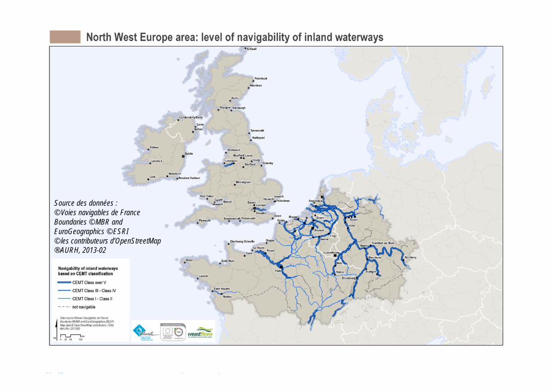
Source des données :© Voies navigables de FranceBoundaries © MBR and EuroGeographics © ESRI© les contributeurs d’OpenStreetMap® AURH, 2013-02
35
Explo
itatio
n OS
M –
AURH
–Pr
ojet e
urop
éen
Wea
stflow
s–04
/04/
2014
–v1
.1 –
CC:B
Y-SA
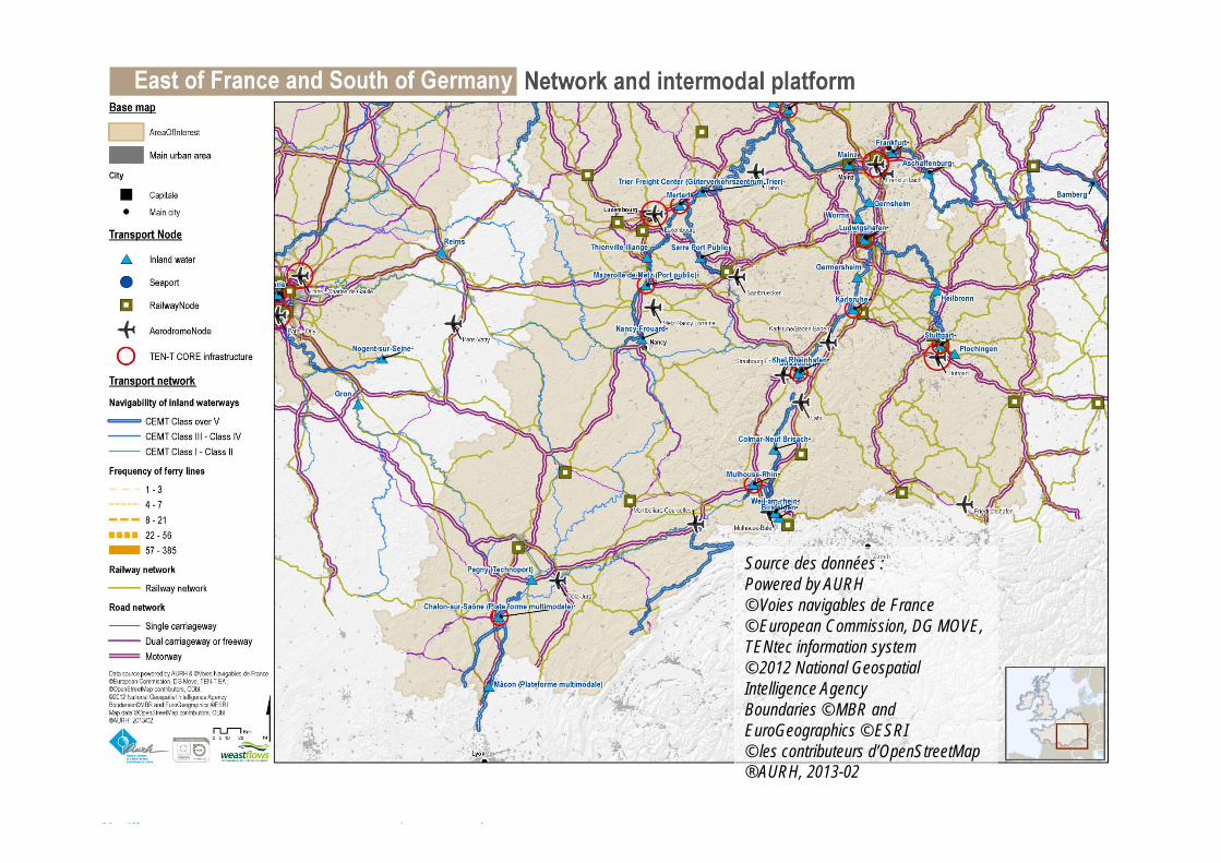
Source des données :Powered by AURH© Voies navigables de France© European Commission, DG MOVE, TENtec information system© 2012 National GeospatialIntelligence AgencyBoundaries © MBR and EuroGeographics © ESRI© les contributeurs d’OpenStreetMap® AURH, 2013-02

OSM -> SIG -> Geoweastflows
State of the Map 2014 FranceParis, 4 avril 2014
JF Mary, AURH

37
Explo
itatio
n OS
M –
AURH
–Pr
ojet e
urop
éen
Wea
stflow
s–04
/04/
2014
–v1
.1 –
CC:B
Y-SA
Topics LayersOthers Open to other data (flows, gateways)
Traffic Maritime, Port (container, RoRo, Cargo, Liquid or dry bulk), Airport
Corridor Classification of infrastructures: main or secondary (by network)
Projects Creation or improvement of infrastructureMajor european projects: ERTMS, Eurocarex
Capacity Channel depths (ports), electrification of railways,runway (airport), CEMT class (waterways), form of way (roads)
Infrastructure Nodes (with intermodality): ports, railway terminals, airportsLinks: Road, Railways, Waterways
Land use Population density, Surface dedicated to industry or transport
Thematic data Inhabitants, Gross domestic product, modal split, short sea or deep sea shipping...
Boundaries NWE boundary, Countries, NUTS1, NUTS2, NUTS3, AOI
Base Map Coastline, Sea, maritime zones, OSM
Les informations disponibles en libre accès

38
Explo
itatio
n OS
M –
AURH
–Pr
ojet e
urop
éen
Wea
stflow
s–04
/04/
2014
–v1
.1 –
CC:B
Y-SA
De l’Atlas au GéoportailAURHAgence d’Urbanisme de la Région du Havreet de l’Estuaire de la Seinewww.aurh.frwww.aurhinweastflows.com
TUDORCentre de Recherche PublicHenri Tudor au Luxembourg
www.tudor.lu/transport-logistics

39
Explo
itatio
n OS
M –
AURH
–Pr
ojet e
urop
éen
Wea
stflow
s–04
/04/
2014
–v1
.1 –
CC:B
Y-SA
GeoWeastflows : Accès libre et simple• Lien: http://geo.weastflows.eu• Travail en cours
– d’autres informations en cours d’ajout– d’autres fonctionnalités en cours de développement (orientées utilisateur) :
• Indication des corrections utilisateurs• Sauvegarde des cartes préférées• Création de cartes personnalisées
– Calcul d’itinéraires intermodaux avec optimisation temps, coût, CO2– Indication de toutes les sources des informations– Extension de la collecte d’information à toute l’Europe, par d’autres projets– Creation d’une communauté “Opendata” , fournisseurs et utilisateurs
d’informations logistiques en Europe – = le wikipedia geographique du transport et de la logistique en Europe
https://www.youtube.com/watch?v=TOHgPAqTh1o

40
Explo
itatio
n OS
M –
AURH
–Pr
ojet e
urop
éen
Wea
stflow
s–04
/04/
2014
–v1
.1 –
CC:B
Y-SA
Exemple d’utilisation : la «table tangible»
https://www.youtube.com/watch?v=i-N1YSIQvhQ

OSM -> SIG -> Analyse Weastflows
State of the Map 2014 FranceParis, 4 avril 2014
JF Mary, AURH

42
Explo
itatio
n OS
M –
AURH
–Pr
ojet e
urop
éen
Wea
stflow
s–04
/04/
2014
–v1
.1 –
CC:B
Y-SA
Analyse transnationaletransversalité, interactions 1-2-4-5• Carroyage pour s’affranchir du découpage• Simplification en sections:
– Analyse du capacitaire des infrastructures (Action 1)– Implémentation des données de trafic (Action 2)– Détermination des situations de congestion (Action 1)
• Matrice d’interaction spatiale (Action 4)• Recherche de « routes intermodales » (Action 5)

43
Explo
itatio
n OS
M –
AURH
–Pr
ojet e
urop
éen
Wea
stflow
s–04
/04/
2014
–v1
.1 –
CC:B
Y-SA
Carroyage (ex : densité de population)
Des carreaux de 800km2pour l’analyse

44
Explo
itatio
n OS
M –
AURH
–Pr
ojet e
urop
éen
Wea
stflow
s–04
/04/
2014
–v1
.1 –
CC:B
Y-SA
Carroyage (ex: densité infra « rail »)

45
Explo
itatio
n OS
M –
AURH
–Pr
ojet e
urop
éen
Wea
stflow
s–04
/04/
2014
–v1
.1 –
CC:B
Y-SA
Du tronçon à la section(Actions 1 et 2)
Tronçon (élément) Section (homogène)

46
Explo
itatio
n OS
M –
AURH
–Pr
ojet e
urop
éen
Wea
stflow
s–04
/04/
2014
–v1
.1 –
CC:B
Y-SA
Un réseau simplifié (Actions 1 et 2)
Railways : 4 431 sections, 3 175 nodesRoads : 3 064 sections, 2 216 nodes
Inland waterways:188 sections, 235 nodes
And with:64 ferries / RoRo
71 major ports, 36 major airports

47
Explo
itatio
n OS
M –
AURH
–Pr
ojet e
urop
éen
Wea
stflow
s–04
/04/
2014
–v1
.1 –
CC:B
Y-SA
Exemple d’une section routièreCollecte d’informations locales
48
Explo
itatio
n OS
M –
AURH
–Pr
ojet e
urop
éen
Wea
stflow
s–04
/04/
2014
–v1
.1 –
CC:B
Y-SA
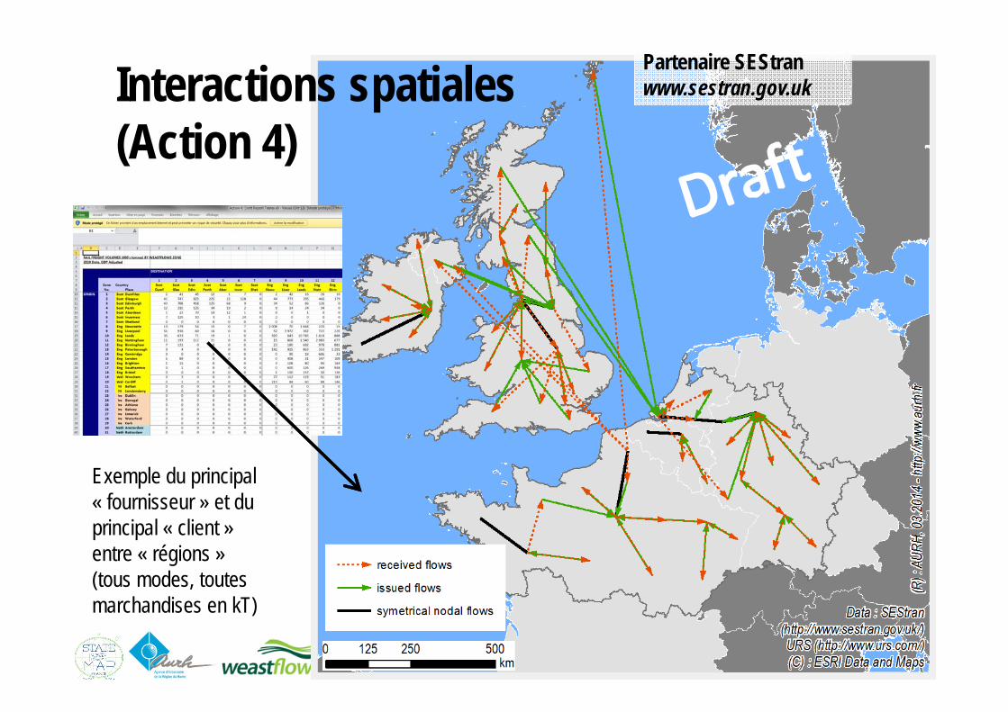
Interactions spatiales(Action 4)
Exemple du principal « fournisseur » et du principal « client » entre « régions »(tous modes, toutes marchandises en kT)
Partenaire SEStranwww.sestran.gov.uk

49
Explo
itatio
n OS
M –
AURH
–Pr
ojet e
urop
éen
Wea
stflow
s–04
/04/
2014
–v1
.1 –
CC:B
Y-SA
Recherche de routes minimisant le CO2 (Action 5)Exemple «Bettembourg (LU) -> Dublin (IE)»
Mode routier problématique
Partenaire Tudorhttp://www.tudor.lu/fr

50
Explo
itatio
n OS
M –
AURH
–Pr
ojet e
urop
éen
Wea
stflow
s–04
/04/
2014
–v1
.1 –
CC:B
Y-SA
PerspectivesWeastflows• Gestion des sources (hstore)• Geoweastflows:
Métadonnées, Services de téléchargement• Consolidation des données « dérivées »• Pérennisation: Mise à jour différentielle• Reverser à la communauté OSM
Pour l’AURHUtiliser OSM dans d’autres projets avec une contribution plus directe:• Adresses, commerces, qualification du bâti, zones d’activités…

51
Explo
itatio
n OS
M –
AURH
–Pr
ojet e
urop
éen
Wea
stflow
s–04
/04/
2014
–v1
.1 –
CC:B
Y-SA
Merci de votre attention
AURH - http://www.aurh.frAgence d’urbanisme de la Région du Havre et de l’Estuaire de la Seine
4 quai Guillaume le TestuF-76600 LE HAVRE (France)
Weastflows à l’AURH - http://aurhinweastflows.comJean-François Mary, responsable SIG, [email protected]
Lucile Audièvre et Mathilde Mus, géographes-géomaticiennesJuliette Duszynski, chef de projet
Avec l’expertise de Frédéric James, Architecte-DBA, société Initio®, Le Havre
http://geo.weastflows.euTUDOR - http://www.tudor.lu/en/transport-logistics
Centre de Recherche Public Henri Tudor - LuxembourgLaurent Vergnol, chef de projet