depliant velotourisme...
TRANSCRIPT
Accueil vélo Ventoux Des professionnels à votre service !
"Ventoux Cyclists Welcome" network Professionals at your service !
"Fietsers welkom " Vaklui tot uw dienst !
Loueurs et accompagnateurs vélo, hébergeurs et restaurateurs, producteurs et artisans, sites de loisirs et agences de voyage, offices de tourisme… Plus de 100 professionnels du tourisme, signataires de la charte "Accueil vélo", s’engagent à vous proposer un ensemble de services pour faciliter votre séjour à vélo.
Quelques exemples de services + :
Bicycle renters and accompanying guides, accommodations and food, farmers and craftsmen, leisure activities, taxis and travel agencies, tourist offices … Over 100 tourism professionals have signed the Welcome Cyclists charter and committed to offering you a set of services to make your cycling stay easy and fun.
Examples of services +: Accommodations: safe parking for bikes.Restaurants: special cyclists’ menu. Growers and craftspersons: fill your water bottle, get your purchases delivered … Bicycle renters: repair and assistance.
Fietsverhuurders, gidsen, horecahouders, producenten en ambachtslui, recreatiegebieden, taxibedrijven en reisbureaus, V.V.V … Meer dan 100 bedrijven uit de toeristenbranche hebben het handvest 'Fietsers Welkom!' ondertekend en garanderen u daarmee een fietsvriendelijk servicepakket voor een onbezorgde fietsvakantie.
Enkele voorbeelden van verleende service: Bij de logiesverstrekkers : een veilige fietsenstalling.Bij de restauranthouders : een speciaal menu voor fietsers. Bij producenten en ambachtslui: mogelijkheid uw waterbidon te vullen en uw aankopen te laten leveren. Fietsverhuurders: hulp bij reparatie.
Chez les hébergeurs : un local sécurisé pour les vélos.
Chez les restaurateurs : un menu adapté aux cyclistes.
Chez les producteurs et artisans : possibilité de remplir votre bidon d’eau, possibilité de livraison de vos achats.
Chez les loueurs de vélo : assistance dépannage.
Découvrez l’ensemble des professionnels « Accueil vélo Ventoux » sur le site :See all the “Ventoux Cyclists Welcome” professionals on the website :Alle deelnemers aan "Fietsers welkom " zijn te vinden op de website :
www.destination-ventoux.com ou www.provence-a-velo.fr.
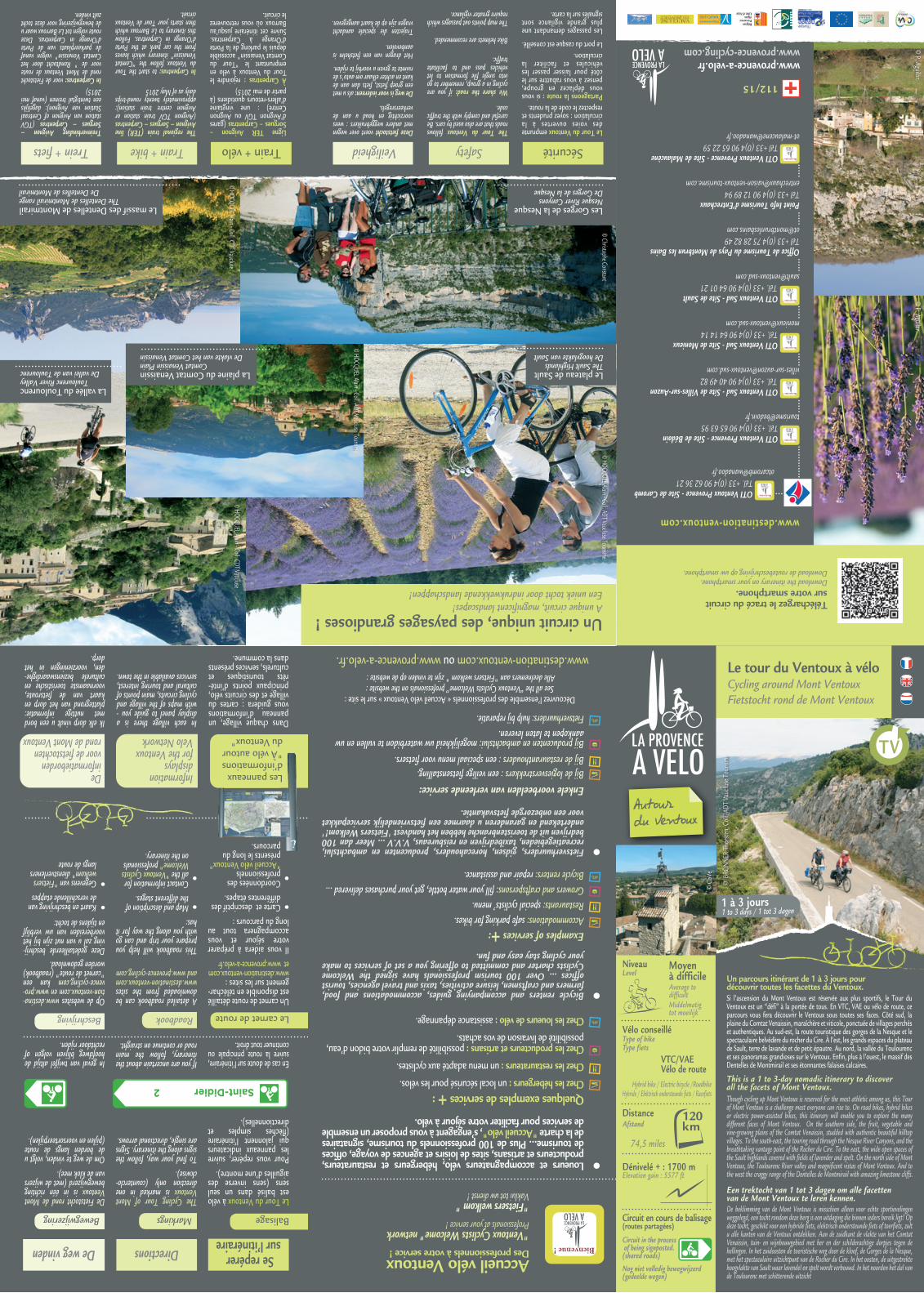
Le tour du Ventoux à véloCycling around Mont Ventoux Fietstocht rond de Mont Ventoux
Distance
Afstand
Dénivelé + : 1700 mElevation gain : 5577 ft
Circuit en cours de balisage(routes partagées)
Circuit in the process of being signposted.(shared roads)
Nog niet volledig bewegwijzerd (gedeelde wegen)
Niveau
Level Moyen à difficileAverage todifficult
Middelmatig tot moeilijk
Vélo conseillé
Type of bike
Type fietsVTC/VAEVélo de route
Hybrid bike / Electric bicycle /RoadbikeHybride / Elektrisch ondersteunde fiets / Racefiets
This is a 1 to 3-day nomadic itinerary to discoverall the facets of Mont Ventoux.
Een trektocht van 1 tot 3 dagen om alle facettenvan de Mont Ventoux te leren kennen.
120
74,5 miles
Si l’ascension du Mont Ventoux est réservée aux plus sportifs, le Tour du Ventoux est un “défi” à la portée de tous. En VTC, VAE ou vélo de route, ce parcours vous fera découvrir le Ventoux sous toutes ses faces. Côté sud, la plaine du Comtat Venaissin, maraîchère et viticole, ponctuée de villages perchés et authentiques. Au sud-est, la route touristique des gorges de la Nesque et le spectaculaire belvédère du rocher du Cire. À l’est, les grands espaces du plateau de Sault, terre de lavande et de petit épautre. Au nord, la vallée du Toulourenc et ses panoramas grandioses sur le Ventoux. Enfin, plus à l’ouest, le massif des Dentelles de Montmirail et ses étonnantes falaises calcaires.
Though cycling up Mont Ventoux is reserved for the most athletic among us, this Tour of Mont Ventoux is a challenge most everyone can rise to. On road bikes, hybrid bikes or electric power-assisted bikes, this itinerary will enable you to explore the many different faces of Mont Ventoux. On the southern side, the fruit, vegetable and vine-growing plains of the Comtat Venaissin, studded with authentic beautiful hilltop villages. To the south-east, the touring road through the Nesque River Canyons, and the breathtaking vantage point of the Rocher du Cire. To the east, the wide open spaces of the Sault highlands covered with fields of lavender and spelt. On the north side of Mont Ventoux, the Toulourenc River valley and magnificent vistas of Mont Ventoux. And to the west the craggy range of the Dentelles de Montmirail with amazing limestone cliffs.
De beklimming van de Mont Ventoux is misschien alleen voor echte sportievelingen weggelegd, een tocht rondom deze berg is een uitdaging die binnen ieders bereik ligt! Op deze tocht, geschikt voor een hybride fiets, elektrisch ondersteunde fiets of toerfiets, zult u alle kanten van de Ventoux ontdekken. Aan de zuidkant de vlakte van het Comtat Venaissin, tuin- en wijnbouwgebied met her en der schilderachtige dorpjes tegen de hellingen. In het zuidoosten de toeristische weg door de kloof, de Gorges de la Nesque, met het spectaculaire uitzichtpunt van de Rocher du Cire. In het oosten, de uitgestrekte hoogvlakte van Sault waar lavendel en spelt wordt verbouwd. In het noorden het dal van de Toulourenc met schitterende uitzicht
Un parcours itinérant de 1 à 3 jours pour découvrir toutes les facettes du Ventoux.
© B
RÖNN
ER T
horst
en C
oll.
ADT
Vauc
luse
Tou
rism
e
1 à 3 jours1 to 3 days / 1 tot 3 dagen
© C
oVe
OTI Ventoux Provence - Site de Caromb Tél. +33 (0)4 90 62 36 [email protected]
www.destination-ventoux.com
www.provence-a-velo.fr www.provence-cycling.com
112/15
OTI Ventoux Provence - Site de Bédoin Tél. +33 (0)4 90 65 63 [email protected]
OTI Ventoux Sud - Site de Villes-sur-Auzon Tél. +33 (0)4 90 40 49 [email protected]
OTI Ventoux Sud - Site de MonieuxTél. +33 (0)4 90 64 14 14
OTI Ventoux Sud - Site de Sault Tél. +33 (0)4 90 64 01 [email protected]
Office de Tourisme du Pays de Montbrun les BainsTél +33 (0)4 75 28 82 [email protected]
Point Info Tourisme d’EntrechauxTél +33 (0)4 90 12 89 [email protected]
OTI Ventoux Provence - Site de Malaucène Tél +33 (0)4 90 65 22 [email protected]
Téléchargez le tracé du circuit sur votre smartphone. Download the itinerary on your smartphone.Download de routebeschrijving op uw smartphone.
© P. Aguilar.
© P. Aguilar.
Se repérer sur l’itinéraireDirectionsDe weg vinden
Le Tour du Ventoux à vélo est balisé dans un seul sens (sens inverse des aiguilles d’une montre).
Pour vous repérer, suivre les panneaux indicateurs qui jalonnent l’itinéraire (flèches simples et directionnelles).
En cas de doute sur l’itinéraire, suivre la route principale ou continuer tout droit.
The Cycling Tour of Mont Ventoux is marked in one direction only (counterclo-ckwise).
To find your way, follow the signs along the itinerary. Signs are single, directional arrows.
If you are uncertain about the itinerary, follow the main road or continue on straight.
De Fietstocht rond de Mont Ventoux is in één richting bewegwijzerd (met de wijzers van de klok mee).
Om de weg te vinden, volgt u de borden langs de route (pijlen en voorsorteerpijlen).
In geval van twijfel altijd de hoofdweg blijven volgen of rechtdoor rijden.
MarkingsBewegwijzering Balisage
Un carnet de route détaillé est disponible en téléchar-gement sur les sites : www.destination-ventoux.comet www.provence-a-velo.fr
Il vous aidera à préparer votre séjour et vous accompagnera tout au long du parcours : Carte et descriptif des différentes étapes.
Coordonnées des professionnels "Accueil vélo Ventoux" présents le long du parcours.
Op de websites www.destina-tion-ventoux.com en www.pro-vence-cycling.com kan een "carnet de route" (roadbook) worden gedownload. Deze gedetailleerde beschrij- ving zal u van nut zijn bij het voorbereiden van uw verblijf en tijdens de tocht:
Kaart en beschrijving van de verschillende etappes Gegevens van "Fietsers welkom" dienstverleners langs de route
Dans chaque village, un panneau d’informations vous guidera : cartes du village et des circuits vélo, principaux points d’inté-rêts touristiques et culturels, services présents dans la commune.
In each village there is a display panel to guide you - with maps of the village and cycling circuits, main points of cultural and touring interest, services available in the town.
Ik elk dorp vindt u een bord met nuttige informatie: plattegrond van het dorp en kaart van de fietsroute, voornaamste toeristische en culturele bezienswaardighe-den, voorzieningen in het dorp.
A detailed roadbook can be downloaded from the sites www.destination-ventoux.com and www.provence-cycling.com
This roadbook will help you prepare your trip and can go with you along the way for it has: Map and description of the different stages. Contact information for all the "Ventoux Cyclists Welcome" professionals on the itinerary.
Roadbook
Information displays for the Ventoux Velo Network
De informatieborden voor de fietstochtenrond de Mont Ventoux
Beschrijving
Les panneaux d’informations "À vélo autour du Ventoux"
Le carnet de route
La plaine du Comtat VenaissinComtat Venaissin Plain
De vlakte van het Comtat Venaissin
Le plateau de SaultThe Sault HighlandsDe hoogvlakte van Sault
Les Gorges de la NesqueNesque River CanyonsDe Gorges de la Nesque
Le massif des Dentelles de Montmirail The Dentelles de Montmirail range
De Dentelles de Montmirail
La vallée du ToulourencToulourenc River Valley
De vallei van de Toulourenc
SécuritéSafetyVeiligheid Train + véloTrain + bikeTrein + fietsLe Tour du Ventoux emprunte des voies ouvertes à la circulation : soyez prudents et respectez le code de la route. Partageons la route : si vous vous déplacez en groupe, pensez à vous rabattre sur le côté pour laisser passer les véhicules et faciliter la circulation. Le port du casque est conseillé.
Les passages demandant une plus grande vigilance sont signalés sur la carte.
The Tour du Ventoux follows roads that are also used by cars. Be careful and comply with the traffic code.
We share the road: if you are cycling in a group, remember to go into single file formation to let vehicles pass and to facilitate traffic.
Bike helmets are recommended.
The map points out passages which require greater vigilance.
Deze fietstocht voert over wegen met andere weggebruikers : wees voorzichtig en houd u aan de verkeersregels.
De weg is voor iedereen: als u met een groep fietst, fiets dan aan de kant en achter elkaar om auto's de ruimte te geven u voorbij te rijden.
Het dragen van een fietshelm is aanbevolen.
Trajecten die speciale aandacht vragen zijn op de kaart aangegeven.
Ligne TER Avignon – Sorgues – Carpentras (gares d’Avignon TGV ou Avignon Centre) : une vingtaine d’allers-retours quotidiens (à partir de mai 2015)À Carpentras : rejoindre le Tour du Ventoux à vélo en empruntant le "Tour du Comtat Venaissin" accessible depuis le parking de la Porte d’Orange à Carpentras. Suivre cet itinéraire jusqu’au Barroux où vous retrouverez le circuit.
The regional train (TER) line Avignon – Sorgues – Carpentras (Avignon TGV train station or Avignon centre train station): approximately twenty round-trips daily as of May 2015
In Carpentras: to start the Tour du Ventoux follow the “Comtat Venaissin” itinerary which leaves from the car park at the Porte d’Orange in Carpentras. Follow this itinerary to Le Barroux which then starts your Tour de Ventoux circuit.
Treinverbinding Avignon – Sorgues – Carpentras (TGV station van Avignon of Centraal Station van Avignon): dagelijks een twintigtal treinen (vanaf mei 2015)In Carpentras: voor de Fietstocht rond de Mont Ventoux de route voor de " Rondtocht door het Comtat Venaissin" volgen vanaf de parkeerplaats van de Porte d’Orange in Carpentras. Deze route volgen tot Le Barroux waar u de bewegwijzering voor deze tocht zult vinden.
Un circuit unique, des paysages grandioses !A unique circuit, magnificent landscapes!Een uniek tocht door indrukwekkende landschappen!
© HOCQUEL Alain - Coll. ADT Vaucluse Tourisme
© HOCQUEL Alain - Coll. CDT Vaucluse© HOCQUEL Alain - Coll. CDT Vaucluse
© Christophe Constant
© HOCQUEL Alain - Coll. ADT Vaucluse Tourisme
TV
CARPENTRAS
MALAUCÈNE
LE BARROUX
SUZETTE
CAROMB
BÉDOIN
CRILLON-LE-BRAVE
ENTRECHAUX
VILLE-SUR-AUZON
MONIEUX
SAULT
AUREL
REILHANETTE
SAVOILLANS
BRANTES
ST-LÉGER-DU-VENTOUX
MORMOIRON
MAZAN
MODÈNEFLASSAN
Le tour du Ventoux à véloCycling around Mont Ventoux Fietstocht rond de Mont Ventoux
N
Source : SCAN100©IGN - PFAR 2008Réalisation : service Connaissance & Cartographie du Territoire de la CoVe - janvier 2015
Chemin ou route non goudronnée / Unpaved road or path / Ongeasfalteerd(e) pad of weg
Autres circuits vélo
Variante pour les vélos de route / Option for road bikes / Variant voor toerfietsen
05 km
Liaison Carpentras > Caromb / Connecting route Carpentras > Caromb / Verbindingsroute Carpentras > Caromb : 11,5 km - 7,1 miles
Attention ! Route fréquentée, soyez prudents ! / Crowed road: be very careful when cycling on it or crossing it. / Opgelet! Drukke weg, wees voorzichtig!
Entre Ventoux et DentellesAu pied des DentellesAutour du CanalEntre plaine et piémontAux portes du VentouxAu fil du ComtatLes Terrasses du VentouxLes Gorges de la Nesque
Départ 1
Départ 2
MONT VENTOUX
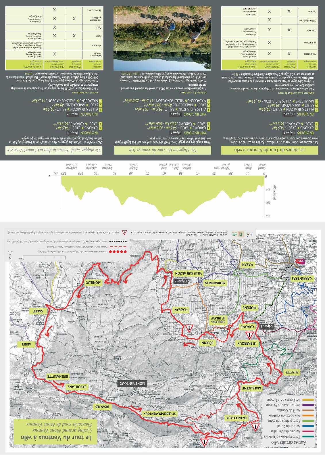
Les étapes du Tour du Ventoux à vélo The Stages on the Tour du Ventoux trip De etappes van de Fietstocht door het Comtat Venaissin
x
Ces étapes sont données à titre indicatif. Grâce au carnet de route,vous pourrez construire votre séjour et suivre le parcours à votre rythme.
These stages are our suggestions. With the roadbook you can put together your own trip and follow this itinerary at your own pace.
Deze worden ter informatie gegeven. Aan de hand van de beschrijving kunt u zelf uw trektocht organiseren en de route in uw eigen tempo volgen.
EN 2 JOURS 1 CAROMB ➤ SAULT : 54,5 km*2 SAULT ➤ CAROMB : 65,5 km**
EN 3 JOURS VILLES-SUR-AUZON ➤ SAULT : 29,5 km SAULT ➤ MALAUCENE : 49 km** MALAUCENE ➤ VILLES-SUR-AUZON : 41 ,5 km*
Variantes pour les vélos de route * À Crillon-le-Brave : continuer sur la D138 pour éviter la zone des anciennes carrières (portion non goudronnée)** Après Saint-Léger-du-Ventoux (variante + sportive) : au niveau du carrefour D40/D40a, tourner à gauche en direction du hameau de Veaux. Traverser le hameau et continuer sur la D242 jusqu’à Malaucène (Savoillans-Malaucène = 33 km).
2
1
1
23
IN 2 DAGEN 1 CAROMB ➤ SAULT : 54,5 km*2 SAULT ➤ CAROMB : 65,5 km**
IN 3 DAGEN VILLES-SUR-AUZON ➤ SAULT : 29,5 km SAULT ➤ MALAUCENE : 49 km** MALAUCENE ➤ VILLES-SUR-AUZON : 41 ,5 km*
Variant voor toerfietsen * In Crillon-le-Brave : de D138 blijven volgens om het gebied van de voormalige steengroeven te vermijden (niet geasfalteerd).** Na Saint-Léger-du-Ventoux (sportiever) : terg hoogte van het kruispunt D40/D40a, links afslaan richting "hameau de Veaux". Het gehucht doorrijden en de D242 blijven volgen tot Malaucène (Savoillans-Malaucène = 33 km).
2
1
1
23
WITHIN 2 DAYS 1 CAROMB ➤ SAULT : 54,5 km - 33,8 miles*2 SAULT ➤ CAROMB : 65,5 km - 40,6 miles**
WITHIN 3 DAYS VILLES-SUR-AUZON ➤ SAULT : 29,5 km - 18,3 miles SAULT ➤ MALAUCENE : 49 km - 30,5 miles** MALAUCENE ➤ VILLES-SUR-AUZON : 41 ,5 km - 25,8 miles*
Optional for road bikes* In Crillon-le-Brave: continue on the D138 to avoid the unpaved area aroundthe old quarries.** After Saint-Léger-du-Ventoux (+ challenging): at the D40/D40a crossroads,turn left in the direction of the hamlet of Veaux. Cycle through the hamlet and continue on the D242 to Malaucène (Savoillans-Malaucène = 33 km - 20.5 miles).
2
1
1
23
Départ 1
Départ 2Départ 2Départ 2
Départ 1Départ 1
Services ServicesVoorzieningen
PharmaciePharmacyApotheek
AlimentationGrocery storesLevensmiddelenwinkel
Jours de marchéMarket daysMarktdagen
Villes-sur-Auzonx
Mercredi matinWednesday morningWoensdagmorgen
MonieuxDimanche matin (de mai à août)Sunday morning (Mai to August)Zondagmorgen (van mei tot augustus)
SaultxxMercredi matinWednesday morningWoensdagmorgen
AurelxMontbrun les Bainsxx
Samedi matinSaturday morningZaterdagmorgen
Entrechauxx
Services ServicesVoorzieningen
PharmaciePharmacyApotheek
AlimentationGrocery storesLevensmiddelenwinkel
Jours de marchéMarket daysMarktdagen
MalaucènexxMercredi matinWednesday morningWoensdagmorgen
Le BarrouxxSamedi matin (mai à septembre)Saturday morning (May to September)Zaterdagmorgen (van mei tot september)
CarombxxMardi matinTuesday morningDinsdagmorgen
Crillon-le-BravexBédoinxx
Lundi matinMonday morningMaandagmorgen
Altitude (m)
CarombVilles-sur-Auzon(0 km)
Bédoin(10 km)(25 km)
Monieux(47,5 km)
Sault(54,5 km)
Aurel(59 km)
St-Léger(79 km)
Entrechaux(94 km)
Malaucène(103,5 km)
Le Barroux(116,5 km)
250
500
750
00102030405060708090100110120km
© B
RÖ
NN
ER Thorsten C
oll. AD
T Vaucluse Tourisme